History of 308 Newell Street, Walla Walla, WA
Legal Description
Roberts W 15’ of Lot 2 Blk 12; Lot 3 Blk 12
Full Legal Description
All of Lot 3 in Block 12 of Roberts’ Addition to the City of Walla Walla, according to the Official Plat thereof of record in the Office of the Auditor of Walla Walla County, Washington, in Book A of Plats at Page 21. Also, all that part of Lot 2 in said Block 12 of Roberts’ Addition to the City of Walla Walla as aforesaid, lying Westerly of a line drawn parallel to and 15 feet Easterly, measured at right angles, from the Westerly line of Lot 2. Situated in the City and County of Walla Walla, State of Washington.
Title and Occupant History
Washington Territory was created in 1853. In 1854, the new territorial legislature created Walla Walla County, which stretched from the crest of the Cascade Mountains to the crest of the Rocky Mountains in the present states of Washington, Idaho and Montana. In 1855, Isaac Stevens, governor of Washington Territory, held a council on the banks of Mill Creek at the present site of Walla Walla with representatives of regional Indian tribes to purchase land from them. The Yakamas, Cayuses and Walla Wallas were dissatisfied with the treaties and the intrusion by whites into their lands before the treaties’ ratification, and war followed. Missionaries, former French-Canadian employees of the Hudson Bay Company trading post at Wallula, and soldiers at the military Fort Walla Walla were the primary European occupants of the area prior to 1859, when the treaties were finally ratified and the land was opened for settlement. The transfer of ownership occurred by virtue of a treaty signed on June 9, 1855 in Walla Walla and ratified on March 8, 1859 by President James Buchanan, in which all of the land in the Walla Walla area was acquired from the Cayuse and Walla Walla Indian tribes.
The town of Walla Walla was originally laid out by County Surveyor Hamet Hubbard Case in 1859, prior to its formal incorporation as a city in 1862, as a one-quarter mile square with its eastern side centered on the point where Main Street crossed Mill Creek (at roughly the point where it does now). The original plat was lost, probably in the fire of 1865. Thus, the earliest plat on file is one made by W. W. Johnson, City Surveyor, in July 1865 that claims to have made corrections to Case’s survey. Johnson’s survey was made the official plat of the City of Walla Walla on September 25, 1866, was filed and recorded July 5, 1867.
Roberts’ Addition to the City of Walla Walla
A. B. Roberts and his wife, Martha, left Portland, Oregon. In 1859, traveling upriver to The Dalles, and eventually by land on to Wallula, Washington Territory. From there they ventured on to Fort Walla Walla, at that time located along what is now East Main Street east of 1st, where Roberts determined to remain, purchasing property from Tom Hughes near the current northeast corner of 1st and Alder Street for $250. He constructed a house of canvas and poles about 150 feet south of that corner. He fenced in additional land around his rudimentary house and held it until the small town was surveyed. Roberts was one of 42 men selected to run for city office in 1862 in an effort to curb crime in Walla Walla; it appears he was neither elected nor appointed to office.
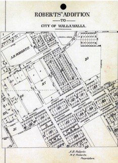
Eventually A. B. and Martha Roberts extended their holdings, including acreage granted by the United States Government under the Homestead Act that ranged from approximately First Street on the west to approximately Howard Street on the east, and from approximately L Street on the south to Alder Street to the north. Platted in 1870, the land was recorded January 20, 1871 as Roberts’ Addition to the City of Walla Walla. (See illustration of plat map).
7/27/1871, Warranty Deed, A. B. and Martha E. Roberts, grantors; Emil W. Evertz and J. F. Charles Abel, grantees, Lots 1-8, Block 12, $400. Evertz owned Pioneer Furniture Store on the south side of Main between 3rd and 4th. Charles Abel was listed in the earliest city directory, published in San Francisco in 1865, that included portions of California, Oregon, Idaho and Washington Territories, as a civil engineer in Walla Walla, no residence address included. By the time the first Walla Walla city directory was published in 1880 he was a partner in the furniture store known as Eversz & Abel at the Main Street location mentioned above. (It was not uncommon at the time for surnames to have multiple spellings.)
12/13/1873, Sheriff’s Deed, B. W. Griffin, Sheriff; Emil W. Everz (a third spelling) and J. F. Charles Abel to Oliver P. Lacy, Lots 3 and 4, Block 12, following court proceedings of 10/2/1873 involving Sigmund Schwabacher and numerous others, $512.92 in gold coin.
5/21/1874, Deed, Oliver P. Lacy, grantor; William Stephens, grantee, Lots 3 and 4, Block 12, $1,100. William Stephens (1812-1899) was prominent in the early development of Walla Walla. Upon arrival in Walla Walla in 1859, he assumed operation of Dr. Dorsey S. Baker’s store, located on the site of the present Baker Boyer National Bank. The store was prominent as a supplier of miners’ needs for those trekking to the gold mines in Idaho Territory. He invested his earnings in the Walla Walla & Columbia River Railroad Company, becoming Treasurer. He was appointed Register of the United States Land Office when it was established in Walla Walla in 1871, but after four years he quit that appointment and returned to the railroad. He was also for a time a partner in the Rees-Winans Mercantile located on the northeast corner of 2nd and Main. His own building, the Stephens Block, is extant directly next door to the east, though only partially recognizable now, as home to TitleOne (formerly Pioneer Title) and Inland Octopus toy store.
3/21/1877, Deed, Emil W. Evertz et al (Charles and Caroline Able), grantors; Joseph H. Russell, grantee, Lots 3 and 4, $150 in gold coin.
3/21/1877, Warranty Deed, J. H. and Mildred W. Russell, grantors; E. B. Hawley, grantee, Lots 3 and 4, Block 12, and 13 lots in Block 18, $1,000. J. H. and Mildred Russell were not listed in any city directories through 1898. E. B. Hawley, on the other hand, was listed in the 1880 directory as a painter, residing on “Dr. Newell st, Roberts” and a partner with W. A. Judson dba Hawley & Judson, located on Alder between 2nd and 3rd. (Dr. Newell was the original name for Newell Street.)
3/21/1877, Warranty Deed Against Grantor, Emil W. Evertz and J. F. Charles and Carolyn Able (ref. above note re multiple spellings of surnames), grantors; Joseph H. Russell, grantee, Lots 3 and 4, Block 12, $150.
5/31/1890, Quit Claim Deed, John Magann, grantor; Annie Hawley, grantee, Lots 3 and 4, $1.
6/2/1890, Quit Claim Deed, John Magann, grantor; Annie B. Hawley, op. cit., $1.
1/7/1891, Quit Claim Deed, Martha E. and Henry W. Hawley, grantors; Annie B. Hawley, grantee, op. cit., $50.
1/12/1898, Indenture, Anna B. and Fred A. Colt, grantors; James E. Gorman, grantee, Lot 3, Block 12, $1,450 in gold coin. It would appear that Anna (Annie) Hawley was a daughter of
Henry and Martha Hawley who at some point in the 1890s became Mrs. Fred A. Colt. The city directory for 1898 listed F. A. Colt as accountant for J. E. Bingham, residing at 308 Dr. Newell Street, and J. E. Bingham as a physician with office at 7 East Main. James Gorman was a partner in McFaden & Gorman, dealing in agricultural implements at 20-24 East Alder.
5/18/1909, Indenture, James E. and Anna Gorman, grantors; Jacob Myers, Lot 3, Block 12, $1,600. Jacob Myers did not reside at 308 Newell at the date of this sale; he was listed in the 1910 city directory as living in Walla Walla County, R.F.D. 5.
11/13/1925, Administratrix’s Deed, Nancy J. Myers, Administratrix for the estate of Jacob Myers, deceased, grantor; A. L. Anderson, Lot 3, Block 12, $4,400.
10/7/1930, Writ of Attachment, Kerr-Gifford & Company, Inc., a corporation vs. Robert Anderson and A. L. Anderson dba Robert and A. L. Anderson, Lot 3, Block 12 and numerous other properties, $4,763.49. Kerr-Gifford was a Portland-based firm dealing in grain-based foods. Whatever arrangement they had with the Andersons of Walla Walla could not be established.
11/23/1931, Writ of Attachment, Kerr-Gifford & Company vs. Cecil R. Anderson, L. E. Anderson, A. L. and Alice M. Anderson, involving the same properties described in the writ of 10/7/1930, $6,140.44.
7/27/1934, Order of Sale, Kerr-Gifford & Company vs. defendants in the writ of 11/23/1931, involving the above-mentioned properties.
10/14/1935, Certificate of Purchase of Real Estate, Earl K. McEnroe, Sheriff to Kerr-Gifford & Company, Lot 3, Block 12 and other properties for the high bid of $75.
10/14/1935, Sheriff’s Deed, C. A. Woodward, Sheriff, by L. W. Harman, Deputy to Robert Anderson, Lot 3, Block 12 and other properties, $75.
10/14/1935, Quit Claim Deed, August L. and Alice M. Anderson, grantors; Robert and E. Ruth Anderson, grantees, Lot 3, $10 and other valuable considerations.
11/13/1958, Warranty Deed, Robert and E. Ruth Anderson, grantors; Harold A. and Ione N. Nibler, Lot 3 and “all that part of Lot 2…lying Westerly of a line drawn parallel to and 15 feet Easterly, measured at right angles, from the Westerly line of said Lot 2,” $10. This is the first transaction that adds the west 15 feet of Lot 2 to Lot 3. There is no document listed in the file on this property that dates when that portion of Lot 2 was annexed to Lot 3. Harold Nibler came from a farming family and was a lifelong farmer himself. His wife, Neola Ione, was the first registered dietician at St. Mary’s Hospital. Nibler Road runs between Dry Creek Road and Highway 12 near Waterbrook Winery.
2/15/1978, Statutory Warranty Deed, Harold A. and Ione N. Nibler, grantors; Daniel W. and Susan E. Ryan, Lot 3, $10 and other valuable considerations.
3/1/1990, Statutory Warranty Deed, Daniel W. and Carrie L. Ryan, grantors; Stanford L. and Jill I. Bagley, Lot 3, $10 and other valuable considerations.
5/12/2008, Statutory Warranty Deed, Stanford L. and Jill I. Bagley, grantors; Thomas James and Suzanne Maria Doughty, grantees, $10 and other valuable considerations.
6/29/2020, Statutory Warranty Deed, Thomas James and Suzanne Maria Doughty, grantors; Nolan J. and Arianna N. Mischel.
Construction of Building
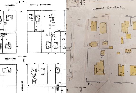
The first edition of the 1905 Sanborn Fire Map (left) shows a house at 308 Dr. Newell that is clearly dissimilar to the current house (right) in a later edition of the 1905 Sanborn Fire Map. Left: courtesy map; right: Whitman Archives.
The Walla Walla County Assessor dates 308 Newell Street to 1906. Assessor dates are frequently estimates. The 1894 Sanborn Fire Map does not show any structure on the lot (the two existing houses shown on that map have addresses of 302 and 320 Dr. Newell Street). The first edition of the 1905 Sanborn Fire Map shows a house with the address of 308 Newell that does not replicate the footprint of the craftsman house currently at that address. As mentioned above, the warranty deed of 11/13/1958 contains the first mention of Lot 3 also including the west 15 feet of Lot 2, although obviously the current house was built decades prior to 1958. Lacking definitive proof, it is speculated that a pre-existing house at 308 Newell was razed in order to construct the house currently at that address. Further, it is probable that Fred and Anna (Annie) Hawley Colt constructed that first house during their ownership of the property between 1894 and 1897. This is based on the fact that prior to 1894 the value of the land was in the hundreds of dollars and when the Colts sold in early 1898 it had increased to over one thousand dollars.
Building permit number 515 was issued to county resident Jacob Myers on 6/11/1909 to construct a dwelling on “Newell near Palouse” estimated to cost $2,800 that appears to be the current house. The builder was J. H. Lewis and the cost of the permit was $150. Thus it is apparent that the house was in fact constructed in 1909. Although Myers was listed under Walla Walla County residents in the 1910 city directory, the 1911-12 directory shows Jacob and Nannie Myers residing at 308 Newell Street. Jacob was a farmer and it was not uncommon for successful farmers to construct a city home. Thus it is apparent that the current house was in fact constructed in 1909.
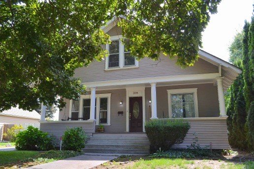
308 Newell is a one and one-half story craftsman style with minimal ornamentation. It has a gabled fore-and-aft roof with a smaller gabled dormer projecting from the east side containing a pair of double-hung windows. Siding is clapboards. A full-width front porch is drawn into rather than projected out from the house, supported by four unadorned round columns. A second pair of double-hung windows graces the overhead pediment. The effect is very pleasing, the house being well maintained.
Resources
- TitleOne (formerly Pioneer Title)
- Whitman Archives (especially Dana Bronson, Associate Archivist, for supplying the photo of the 1905 revised Sanborn Fire Map and the building permit for 308 Newell)
- Walla Walla County Auditor’s Vault Indexes of recorded deeds
- Walla Walla City Directories, various years
- historylink.org
- ancestry.com


