History of 229 Newell Street, Walla Walla, WA
Legal Description
Lot 3 and a portion of Lot 4 of Roberts’ Addition to the City of Walla Walla.
Full Legal Description
Beginning at a point on the Northerly line of Newell Street in the City of Walla Walla, Washington, which point is 150 feet Westerly, measured along said Northerly line of Newell Street, from the point of its intersection with the Westerly line of Palouse Street in said city; and running thence Easterly, along said Northerly line of Newell Street, a distance of 60 feet; thence at right angles Northerly 114 feet and 11 inches more or less to the line of the property formerly owned by C. J. Bowers; thence at right angles Westerly along the line of the said Bowers property 60 feet; thence at right angles Southerly 114 feet and 11 inches more or less to the point of beginning.
Title and Occupant History
Washington Territory was created in 1853. In 1854, the new territorial legislature created Walla Walla County, which stretched from the crest of the Cascade Mountains to the crest of the Rocky Mountains in the present states of Washington, Idaho and Montana. In 1855, Isaac Stevens, governor of Washington Territory, held a council on the banks of Mill Creek at the present site of Walla Walla with representatives of regional Indian tribes to purchase land from them. The Yakamas, Cayuses and Walla Wallas were dissatisfied with the treaties and the intrusion by whites into their lands before the treaties’ ratification, and war followed. Missionaries, former French-Canadian employees of the Hudson Bay Company trading post at Wallula, and soldiers at the military Fort Walla Walla were the primary European occupants of the area prior to 1859, when the treaties were finally ratified and the land was opened for settlement. The transfer of ownership occurred by virtue of a treaty signed on June 9, 1855 in Walla Walla and ratified on March 8, 1859 by President James Buchanan, in which all of the land in the Walla Walla area was acquired from the Cayuse and Walla Walla Indian tribes.
The town of Walla Walla was originally laid out by County Surveyor Hamet Hubbard Case in 1859, prior to its formal incorporation as a city in 1862, as a one-quarter mile square with its eastern side centered on the point where Main Street crossed Mill Creek (at roughly the point where it does now). The original plat was lost, probably in the fire of 1865. Thus, the earliest plat on file is one made by W. W. Johnson, City Surveyor, in July 1865 that claims to have made corrections to Case’s survey. Johnson’s survey was made the official plat of the City of Walla Walla on September 25, 1866, was filed and recorded July 5, 1867.

Plat map of Roberts’ Addition
A. B. Roberts and his wife, Martha, left Portland, Oregon. In 1859, traveling upriver to The Dalles, and eventually by land on to Wallula, W.T. From there they ventured on to Fort Walla Walla, at that time located along what is now East Main Street east of 1st, where Roberts determined to remain, purchasing property from Tom Hughes near the current northeast corner of 1st and Alder Street for $250. He constructed a house of canvas and poles about 150 feet south of that corner. He fenced in additional land around his rudimentary house and held it until the small town was surveyed. Roberts was one of 42 men selected to run for city office in 1862 in an effort to curb crime in Walla Walla; it appears he was neither elected nor appointed to office.
Eventually A. B. and Martha Roberts extended their holdings, including acreage granted by the United States Government under the Homestead Act that ranged from approximately First Street on the west to approximately Howard Street on the east, and from approximately L Street on the south to Alder Street to the north. Platted in 1870, the land was recorded January 20, 1871 as Roberts’ Addition to the City of Walla Walla. (See illustration of plat map on Page 2.
1/29/1872, Warranty Deed, A. B. and Martha E. Roberts, grantors; Lizzie Dexter, grantee, Lots 3 & 4, Block 27, $325.
2/2/1872, Warranty Deed, Lizzie and J. B. Dexter, grantors; William Stephens, grantee, Lots 3 & 4, Block 27, $450. William Stephens arrived in Walla Walla in June 1859, entering first into a business arrangement with Dr. Dorsey S. Baker, and later with Paine Bros. & Moore. After selling his business, he invested in the Walla Walla & Columbia River Railroad, becoming treasurer. In 1871, following the establishment of a United States Land Office in Walla Walla, Mr. Stephens was appointed Registrar.
6/26/1874, Warranty Deed, William Stephens, grantor; B. L. Sharpstein, grantee, Lots 9-12, Block 13 and Lots 3 & 4, Block 27, $650.
1/21/1879, Warranty Deed, B. L. and Sarah J. Sharpstein, grantors; Anna L. Painter, grantee, Lot 3, Block 27, $800.
5/4/1880, Warranty Deed, Anna S. and J. C. Painter, grantors; C. C. McCoy, grantee, “…commencing on the North line of Dr. Newell Street at a point 250 feet Easterly from the East line of Catherine Street, thence Easterly 150 feet to the South East corner of Lot number 3 in Block number 27 in A. B. Roberts’ Addition to the City of Walla Walla, W.T., thence at right angles Northerly to the North East corner of said lot, thence Westerly along the North line of Lots number 3 and 4 150 feet, thence at right angles South to the place of beginning, the same being Lot number 3 and a part of Lot number 4…” $650.
6/19/1883, Warranty Deed, C. C. and Martha McCoy, grantors; Mack F. Gose, grantee, Lot 3 and a portion of Lot 4, Block 27, $1.
6/19/1883, Warranty Deed, Mack F. Gose, grantor; Martha McCoy, grantee, Lot 3 and a part of Lot 4, Block 27, $1.
4/6/1895, Indenture, C. C. and Martha McCoy, grantors; The Baker Boyer National Bank, grantee, Lot 3 and a part of Lot 4, Block 27 and numerous other parcels in Walla Walla, $1 in gold coin.
6/14/1900, Agreement for Deed, Baker Boyer Bank, grantor; W. B. Hamilton, grantee, Lot 3 “and part of Lot 4,” Block 27, $2,500 in gold coin.
10/13/1902, Warranty Deed, Baker Boyer Bank, grantor; W. B. Hamilton, grantee, (same as described in above Agreement for Deed).
5/11/1905, Warranty Deed, W. B. and Kedellia Anna Hamilton, grantors; Andrew Larsen, grantee, Lot 3 and part of Lot 4, $3,800.
7/21/1905, Warranty Deed, Andrew and Della Larsen, grantors; Christian J. Bowers, grantee, Lot 3 and part of Lot 4, $4,200.
11/15/1907, Warranty Deed, Christian J. and Laura V. Bowers, grantors; Adna Sharpstein, grantee, Lot 3 and part of Lot 4, $4,000.
7/6/1911, Deed, Adna Sharpstein of New York City, grantor; Emma Gregg, Lot 3 and part of Lot 4, $6,500.
7/25/1911, Indenture, Herbert C. and Emma Gregg, grantors; Everett J. Smith, grantee, “…commencing on the North side of Newell Street… a distance of 150 feet Westerly of the Northwest corner of the intersection of…Newell Street with the West line of Palouse Street, running Easterly along said North line of Newell Street 60 feet, thence at right angles Northerly 114 feet, more or less, to the line of the property now owned by C. J. Bowers, thence at right angles Westerly along the said side of Bowers property 60 feet, thence Southerly at right angles 114 feet to the point of beginning,” $1 in gold coin.
5/14/1919, Warranty Deed, Everett J. and Edna K. Smith, grantors; Isabel C. McDonald, grantee, $1.
6/26/1923, Agreement for Deed, John H. McDonald, grantor; H. C. Tilley, grantee, $5,500 including paying a mortgage of $3,000 due to Spokane Savings & Loan.
7/25/1923, Quit Claim Deed, Francis B. and Robert Allen, and John H. Pedigo, grantors; John H. McDonald, grantee, $1.
1/13/1927, Executor’s Deed, Union Trust Company, as executor of the Last Will and Testament of John H. McDonald, deceased, grantor; H. C. Tilley, grantee, $1,311.38.
9/18/1934, Quit Claim Deed, W. B. and Edna D. Sutton, grantors; H. C. and Nellie G. Tilley, grantees, $1.
11/13/1934, Warranty Deed, H. C. and Nellie G. Tilley, grantors; Ema Joslin, a widow, $10 and other valuable considerations subject to 1932 and 1933 taxes and a mortgage of $1,540 to Spokane Savings Bank.
10/28/1944, Ema Joslin, a widow, grantor; Iva B. Walls, a widow, $10.
10/4/1947, Iva B. Walls, a widow, Edith Murphy, a widow, $10 and other valuable considerations.
4/13/1965, Executor’s Deed, Mirriam Mitchell, as Executor of the Last Will and Testament of Edith M. Murphy, deceased, grantor; Robert and Violet Loseke, $10 and other valuable considerations. Throughout the 1940s and 50s items about various women who were not owners of but whose addresses were given as 229 Newell were mentioned in newspaper clippings as hosting church, garden club, etc. events. It is probable therefore that the three widows who owned the house during these years rented rooms to women.
4/22/1977, Statutory Warranty Deed, Robert and Violet Loseke, grantors; William R. Loseke, a single man, grantee, $10.
7/30/1983, Statutory Warranty Deed, William R Loseke, a single man, grantor; Leilani R. Duke, a single person, $10 and other valuable considerations.
11/22/1995, Statutory Warranty Deed, Leilani R. Duke, a single person, grantor; Christine and William D. Gerke, grantees, $92,000.
9/13/2019, Lack of Probate Affidavit, Estate of Christine M. Gerke, grantor; William D. Gerke, grantee.
9/13/2009, Statutory Warranty Deed, William D. Gerke, grantor; Barbara Altera, grantee, $200,000.
3/5/2020, Statutory Warranty Deed, Barbara Altera, grantor; Kenneth Alan and Caroline Marie Cogen, grantees.
Construction of Building
The plat map of Roberts’ Addition shows an unconventional division of Block 27 into building lots. Lots 1, 2 and 3 are only a few feet deep and extend the full length of Roberts Street (now South Palouse Street) from what was then Park Street (now Birch Street) to Dr. Newell Street (“Dr.” was excised decades ago). Lots 1 and 2 occupy most of that expanse, Lot 3 making up but a small portion near the corner of Newell Street. Lot 4 occupies the rest of the expanse along Newell Street west to Catherine Street.
On May 4, 1880, J. C. and Anna Painter sold Lot 3 and a portion of Lot 4, Block 27 to C. C. McCoy for $650. McCoy was listed in the city directory for that year as a mail contractor with residence on the north side of Alder Street east of 1st Avenue. Joseph Painter was a clerk residing on the northwest corner of Fourth and Birch.
The Walla Walla County Assessor lists a build date of 1881 for 229 Newell Street. City of Walla Walla building permits preserved at Whitman College Archives do not predate September 1907. The Walla Walla City Directory for 1881 lists C. C. McCoy as superintendent of Western Mail & Transportation Company, with residence at 225 Dr. Newell Street. The 1883 directory had changed his address to 235 Dr. Newell; such numerical changes were not uncommon and there is no reason to believe that 225, 229 and 235 are not indeed the same house. McCoy purchased the property in May 1880, allowing sufficient time that year to have completed his new house for inclusion in the 1881 city directory.
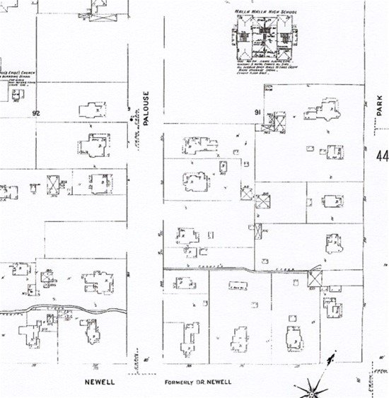
On the 1905 Sanborn Fire Map the house numbers 235 and 255 can be read clearly (second house from the lower left corner).
The 1894 edition is the first Sanborn Fire Map on which 229 Newell Street can be seen. The previous edition of the fire map, 1890, although mapped as far out as Dr. Newell Street, does not include structures in Roberts’ Addition. The 1894 map is very faint and it is difficult to read the address for the house; the 1905 edition is more clear and shows that the house had two house numbers, 235 and 255.
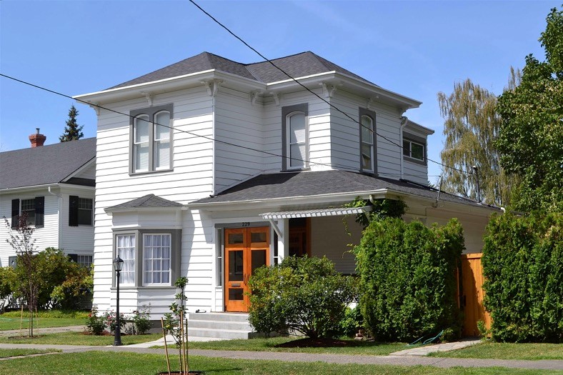
Architecture in the Italianate or Tuscan style had peaked in the East and Midwest during the decades 1850 through 1860s, before 229 Newell Street was constructed. Because of its great distance from the more populated parts of the country, tastes in architecture were slower to appear in the West, including not just Walla Walla, but the larger metropolitan areas of Seattle and Portland.
229 Newell Street has been altered somewhat from its original appearance, but enough remains to place it within the Italianate style of architecture, including its asymmetrical low pitch hipped roof, ornamental roof brackets, and especially the two segmented arch windows at the second level connected under a simple crown (pairs of segmented arch windows grouped under a single round arch hood was a hallmark of Italianate architecture). A companion piece to 229 may be seen across the street at 216 Newell.
Current owners have made substantial improvements to the house, and 229 Newell Street can be considered an attractive and contributing member of this historic residential district.
Resources
- TitleOne (formerly Pioneer Title)
- Walla Walla County Auditor’s vault indexes of recorded deeds
- Gilbert, Frank T., Historic Sketches of Walla Walla, Whitman, Columbia and Garfield Counties, W.T. and Umatilla County, Oregon, Portland, Oregon, 1882
- Walla Walla City Directories, various years
- Walla Walla newspapers, various dates


