History of 1669 Gerking Road, Waitsburg, WA
Legal Description
32-9-37 5-8-37 Parcel 1-B Sur 2014-00297 32-9-37 Tax 4
Full Legal Description
A parcel of land located in Section 5, Township 8 North, Range 37 East of the Willamette Meridian, and Section 32, Township 9 North, Range 37 East of the Willamette Meridian, Walla Walla County, Washington, described more particularly as follows:
Commencing at the North West corner of the South West Quarter of said Section 32; thence North 88°07’33” East along the North line of the South West Quarter of said Section 32 a distance of 2,623.28 feet to the center of said Section 32 and the true point of beginning for this legal description; thence North 31°53’37” East a distance of 584.03 feet; thence North 83°24’37” East a distance of 41461 feet; thence North 31°17’37” a distance of 31105 feet; thence South 31°45’23” a distance of 290.55 feet; thence South 06°56’23” East a distance of 1,002.45 feet; thence South 01°33’24” West a distance of 2,182.99 feet; thence South 17°19’54″a distance of 425.55 feet; thence South 02°44’09” East a distance of 278.51 feet; thence South 06°05’11” West a distance of 305.52 feet; thence South 15°41’55” West a distance of 591.62 feet; thence South 18°12’53” West a distance of 357.98 feet; thence South 32°52’47” West a distance of 262.54 feet; thence South 77°02’27” West a distance of 183.08 feet; thence South 13°13’11” West a distance of 197.22 feet; thence South 40°05’46” East a distance of 559.31 feet; thence South43°04’37” West a distance of 214.42 feet; thence South 63°01’37” West a distance of 246.04 feet; thence South 46°22’23” East a distance of 71.70 feet; thence South 42°45’37” West a distance of 565.52 feet; thence South 38°03’37” West a distance of 465.97 feet to a point which in North 89°39’58” East, measured along the South line of said Section 5 a distance of 2,361.45 feet to a point 284.30 feet West of the South East corner of said South West Quarter of said Section 5 and North 01°49’35” West, parallel to the East line of said South West Quarter a distance of 1,360.94 feet, from the South West corner of said Section 5; thence North 01°52’23” West a distance of 193.90 feet to a point on the centerline of Gerking Road and along the centerline of Gerking Road by the following courses; thence South 44°17’38” West a distance of 438.23 feet; thence with a curve turning to the right having an arc length of 678.13 feet, with a radius of 900.00 feet, with a chord bearing of South 65°52’47 West, with a chord length of 662.21 feet; thence South 87°27’55” West a distance of 38.81 feet; thence with a curve turning to the right having an arc length of 319.49 feet, with a radius of 1,000.00 feet, with a chord bearing of North 83°22’55” West, with a chord length of 318.13 feet; thence North 74°13’45” West a distance of 78.20 feet; thence with a curve turning to the left having an arc length of 71.87 feet, with a radius of 1,735.00 feet, with a chord bearing of North 75°24’57” West, with a chord length of 71.86 feet; and then leaving said road centerline by the following courses; thence North 21°13’37” East a distance of 5,435.11 feet; thence North 17°15’02” West a distance of 1,482.12 feet to a point in a line 330.00 feet South of, when measured at right angles to, the North line of the South West Quarter of said Section 32; thence South 88°10’57” West a distance of 40.32 feet; thence North 02°18’23” West a distance of 150.71 feet; thence North 02°18’23” West a distance of 179.30 feet to the point of beginning.
Together with: beginning at the North West corner of the South West Quarter of said Section 32; thence North 88°07’33” East along the North line of the South West Quarter a distance of 2,623.28 feet to the center of said Section 32; thence South 02°18’23” East a distance of 179.30 feet; thence South 02°18’23” East a distance of 150.71 feet; thence South 88°10’57” West along a line 330.00 feet South of, when measured at right angles to, and parallel with, the North line of the South West Quarter of said Section 32, a distance of 310.51 feet; thence South 23°18’49” West a distance of 2,034.22 feet; thence South 26°34’48” East a distance of 156.89 feet; thence South 24°21’11” East a distance of 533.58 feet; thence South 30°17’25” West a distance of 329.75 feet; thence South 05°08’40” West a distance of 394.36 feet; thence South 18°53’39” West a distance of 419.19 feet; thence South 24°10’00” West a distance of 328.80 feet; thence South 10°18’10” West a distance of 233.38 feet; thence South 23°45’10” West a distance of 332.88 feet; thence South 51°37’27” West a distance of 293.34 feet; thence South 08°13’12” West a distance of 146.21 feet; thence South 31°18’30” West a distance of 286.01 feet; thence South 34°45’38” West a distance of 90.98 feet; thence South 29°03’17” West a distance of 92.94 feet; thence South 55°41’06” West a distance of 172.15 feet; thence South 21°48’05” West a distance of 170.15 feet; thence South 50°27’27” West a distance of 251.69 feet; thence South 60°53’57” West a distance of 105.98 feet to a point in the West line of said Section 5; thence North 01°43’51” West along the West line of said Section 5 a distance of 3,277.76 feet to the North West corner of said Section 5; thence North 01°57’30” West along the West line of the South West Quarter of said Section 32 a distance of 2,583.82 feet to the point of beginning. Subject to easements, encumbrances, roadways and servitudes of record.
Title and Occupant History
Sylvester M. Wait established the Township of Waitsburg in 1865 around a small gristmill he had built. The original name of the small village that grew up around the mill was Delta; it was decided by popular vote in 1868 to adopt the name Waitsburgh with a posterior “h” affixed. Although one source states that no attempt was made to plat the township until 1869 when Perry Bruce undertook this task, the Waitsburg City Administrator, Clerk and Treasurer confirmed the date as 1868.
The Territorial Legislature issued a regular Charter to the City of Waitsburg November 25, 1881. William Preston, mill owner, was mayor. Under the charter, the city was incorporated with the usual powers for the creation of a police force, fire department and water works, and the enforcement of regulations for the safety, health and order of the city. Waitsburg remains to date the only city in Washington to operate under a Territorial Charter, as revised in 1886.
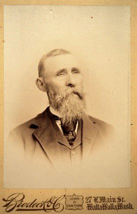
Cornelius (Neal) Cheetham. Washington State Archives photo.
5/6/1882, Patent, Chester A. Arthur, President, by W. H. Crook, Secretary, grantor; Cornelius Cheetham, grantee, “the North East quarter of Section 32, in Township 9, North of Range 37, East of the Willamette Meridian in Washington Territory, containing 160 acres.” Cornelius (Neal) Cheetham was a minister who served the Dixie Christian Church between 1884 and 1886. The current church building, constructed in 1889 three years after Cheetham had left, is reported to be the oldest Christian church building in continuous use in Washington.
5/6/1882, Warranty Deed, Cornelius and Mary C. Cheetham, grantors; Francis W. Morgan, grantee, “the North East quarter of [32-9-37], containing 160 acres, $2,150.
10/23/1882, Warranty Deed, Francis M. and Sarah I. Morgan, grantors; Henry Ingalls, grantee, the East half of [32-9-37], $7,000. Mr. Ingalls, already twice widowed, as reported in Gilbert’s 1882 history of Walla Walla, Garfield, Columbia and Whitman counties, resided 5½ miles southwest of Waitsburg in an area called Spring Valley. This would seem to be an apt description of 1669 Gerking Road, which lies in a picturesque valley between rolling hills of wheat. Gilbert recorded that Ingalls owned two farms, one of 400 acres and one of 200 acres, on one of which was his house.
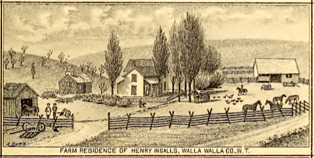
Henry Ingalls’ farmhouse in Spring Valley, 5½ miles southwest of Waitsburg. Illustration from Gilbert’s Historic Sketches of Walla Walla, Whitman, Columbia & Garfield Counties, W.T. 1882.
1/11/1890, Warranty Deed, Henry and Margaret E. Ingalls, grantors; Charles Damerell, grantor, “the East half of” [32-9-37], $7,200.
11/5/1892, Lease, Henry and Margaret Ingalls, Lessors; Charles Damerell, Lessee, (same description as above Warranty Deed), a 4-year lease beginning 11/1/1892 for one-third of all grain raised on the land and payment of all property taxes. (It appears that Charles Damerell defaulted on the above purchase of the above property which Ingalls converted to a lease.)
11/7/1892, Warranty Deed, Charles Damerell, a single man, grantor; Henry Ingalls, grantee, (same description as in Warranty Deed of 1/11/1890), $7,300.
2/3/1902, Warranty Deed, Arthur C. Murphy, unmarried, son and heir of Margaret E. Ingalls, deceased, grantor; Horace J. Murphy, grantee, “the East half of [32-9-37]; also the North half of the North West quarter and the North half of the North East quarter, and the South West quarter of the North East quarter, and the North West quarter of the South East quarter of Section 5, in Township 8 North, of Range 37, East of the Willamette Meridian,” $700. Little could be located regarding Horace J. Murphy, although, importantly, in the following Affidavit of 7/27/1912 it is established that he was an heir and evidently son of Margaret E. Ingalls. The 1902 Walla Walla City Directory listed him in Waitsburg owning 480 acres with a net worth of $2,525. The only listing in the 1904 directory showed his net worth had bumped up to $6,070. In 1905, however, Murphy’s residence was listed at 318 Main Street in Waitsburg, an address that remained consistent through 1911. (It is worth noting that 318 Main Street is the address of the Bruce Memorial Museum.) Presumably, Murphy died that year, as the 1911-12 directory listed Mrs. Ellen Murphy, widow Horace J. Murphy as the sole resident of 318 Main Street.
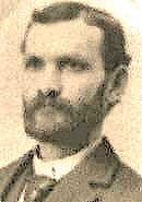
Henry Ingalls, photo by Brodeck & Co., Walla Walla, n.d., Whitman Archives photo.
4/11/1902, Deed, Olive B. Cattron, granddaughter and heir of M. E. Ingalls, deceased, and E. H. Cattron, her husband, grantors; H. J. Murphy, grantee, (same description as in Warranty Deed of 2/3/1902); also “the East half of” [32-9-37], $337.
4/12/1902, Deed, N. S. and Hattie Butler, his wife, grandson and heir of M. E. Ingalls, deceased, grantors; H. J. Murphy, grantee, “the North half of the North East quarter and the South West quarter of the North East quarter and the North West quarter of the South East quarter of Section 5, in Township 8 North, of Range 37 East of the Willamette Meridian; also the East half of [32-9-37], $337.
11/26/1902, Deed, Florence E. Mason, unmarried, daughter and heir of M. E. Ingalls, deceased, grantor; H. J. Murphy, grantee, (same description as in Deed of 4/12/1902), $1,000.
10/4/1904, Lease, W. H. Ingalls and H. J. Murphy, Lessors; Joshua Barnes, Lessee, “the North half of the North West quarter; the North half of the North East quarter; the South West quarter of the North East quarter; and the North West quarter of the South East section of [5-8-37]; and the East half of [32-9-37],” a 4-year lease beginning 10/4/1904 for one-third of all grain raised on the land.
4/24/1905, Warranty Deed, Henry Ingalls, a widower, grantor; Willis H. Ingalls, grantee, one-half interest in “the East half of” [32-9-37]; “also the North half of the North East quarter and the North West quarter of the South East quarter of [5-8-37], containing in all 553.48 acres,” $8,302.20.
6/12/1905, Deed, Otis D. Ingalls, unmarried, son and heir of Margaret E. Ingalls, deceased, grantor; Horace J. Murphy, grantee, “the East half of [32-9-37]; also the North half of the North West quarter and the North half of the North East quarter, and the South West quarter of the North East quarter and the South West quarter of the North East quarter and the North West quarter of the South East quarter of [5-8-37], $1,380.
5/15/1907, Lease, W. H. Ingalls and H. J. Murphy, Lessors; Joshua Barnes, Lessee, “the North half of the North West quarter; the North half of the North East quarter; the South West quarter of the North East quarter; and the North West quarter of the South East section of [5-8-37]; and the East half of [32-9-37],” another 4-year lease beginning 10/4/1908 for one-third of all grain raised on the land.
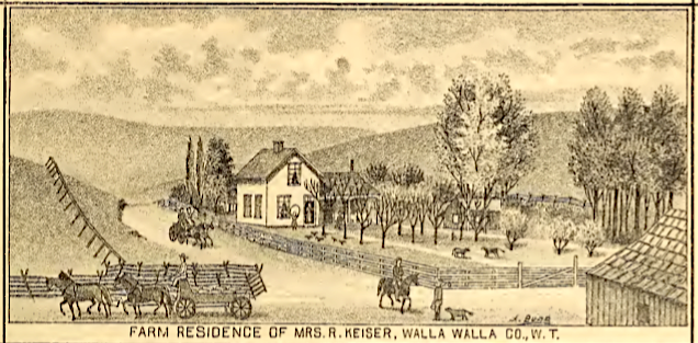
Farmhouse of the widow Roxcia Keiser, sister of Henry Ingalls, also located in Spring Valley. Mrs. Keiser’s farm included the district schoolhouse. Illustration from Gilbert’s Historic Sketches of Walla Walla, Whitman, Columbia & Garfield Counties, W.T., 1882.
7/27/1912, untitled document in the form of an Affidavit, Roxcia Keiser, sister of Henry Ingalls, to The Public, to establish that she knew Margaret Ingalls during her lifetime and that Margaret Ingalls died intestate on 1/26/1893, the H. J. Murphy, Otis D. Ingalls, and Olive B. Cattron are legal heirs of Margaret Ingalls. Roxcia Keiser, a widow whose farm is illustrated below, was listed in the Waitsburg section of Walla Walla city directories as living at 316 Main Street.
1/22/1913, Indenture, Willis H. Ingalls, a widower, grantor; D. M. Schoonover, grantee, “one-half interest in the East half of [32-9-37] and portions of [5-8-37], also the South West quarter of [32-9-37], containing 160 acres more of less, $10 and other and further lawful considerations.” D. M. Schoonover was a member of the Washington Board of Control of the Fifth Dry Farming Congress that met in Spokane in 1910.
7/8/1913, Indenture, Willis H. Ingalls to The Public, an Affidavit validating the sale of the above-described property to D. M. Schoonover, as the highest bidder, for $14, 757.10.
3/7/1914, Indenture, D. M. and Rose L. Schoonover, grantors; William H. Stonecipher, grantee, “the East half of [32-9-37]; also the South West quarter of [32-9-37]; also portions of [5-8-37], containing 713 acres,” $53,475.
5/21/1948, Quit Claim Deed, Grace H. and Mark R. Fletcher, James D. and Helen R. Stonecipher, Harvey V. and Martha M. Stonecipher, May Blanche and Loris K. Cox, Chester B. and Loretta M. Stonecipher, grantors; Lola M. and O. Glenn Conover, grantees, portions of [32-9-37] and [5-8-37], “containing 274.97 acres more or less, excepting therefrom any lands used as public roads,” $10 and other valuable considerations.
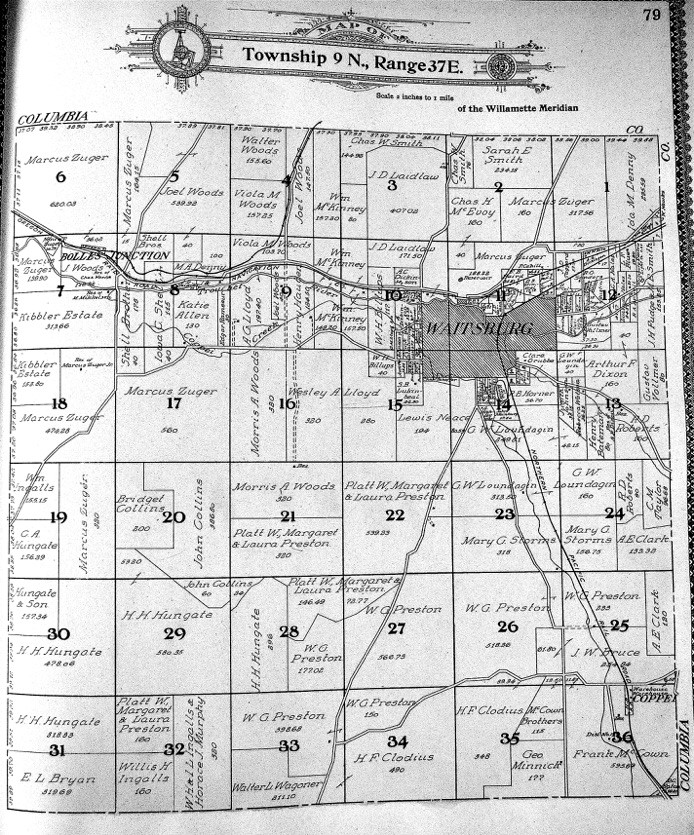
Section 32, Township 9 North, Range 37 East contains two familiar names, Willis Hall Ingalls and Horace J. Murphy. From Standard Atlas of 1909 as listed under Resources.
12/27/1955, Quit Claim Deed, Lola M. Conover, wife of the Grantee, herein, grantor; O. Glenn Conover, husband of the Grantor, grantee, “…that part of Section 32, in Township 9 North, of Range 37 East of the Willamette Meridian, and that part of [5-8-37], containing 274.97 acres more or less, in consideration of ‘Love and Affection.'”
1/9/1989, Easement, Otho Glenn Conover, Winifred Claire Raven and Frances Adelle Ganguet, grantors; United States of America, grantee, “a perpetual non-exclusive easement for access road purposes in, upon and across the following described land in Exhibits A and B (not attached), $950.
1/14/2014, Warranty Deed, Estate of F. Adelle Ganguet, deceased, and Winifred Claire Raven, grantors; Edgar H. and Margaret A. Stonecipher, grantees, undescribed portions of 32-9-37 and 5-8-37.
9/11/2014, Deed of Personal Representative, Estate of Frances Adelle Ganguet, deceased, grantor; Jacqueline O. Brock, Allyson Hurd Dragoo and Allyson Dragoo Hurd, grantees, part of Section 32, in Township 9 North, of Range 37 East of the Willamette Meridian, and part of Section 5 in Township 8 North, of Range 37, East of the Willamette Meridian. The Last Will and Testament of Adelle Ganguet, dated 10/20/2011, stated under Article IV.B., “I give, devise, and bequeath any interest I have in agricultural farm land unto my daughter, Jacqueline C. Brock, and my granddaughter, Allyson Hurd, in equal shares, or the survivor of them…” For a legal description of the land see Pages 1 and 2 above.
Construction of Building
Waitsburg city directories were subsections of Walla Walla city directories, were inconsistently included from year to year, and usually gave minimal information. Although Henry Ingalls, his widowed sister Roxcia Keiser, and his brother Theodore all had farms in Spring Valley in 1882, as illustrated in Gilbert’s above-mentioned history of that year, the illustration of Henry Ingalls’ farm on Page 2 of this report is not what is currently at 1669 Gerking Road; the original patent for this portion of 32-9-37 was not granted to Cornelius (Neal) Cheetham until May 6, 1882.
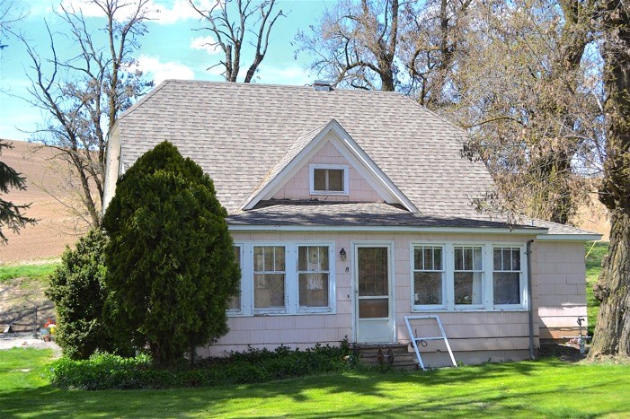
The County Assessor lists a 1903 build date for 1669 Gerking Road. While Assessor dates are frequently estimates, this researcher feels that that date is likely quite accurate. In November 1892 portions of 32-9-37 were sold to Horace J. Murphy. Between February 1902 and November 1902, various members of the extended Ingalls family were busy offloading portions of this section to Mr. Murphy, which tends to suggest that he was making a significant investment in the land at that time. As the last of these deeds did not occur until late in 1902, it is likely that the house was constructed in 1903 by Horace Murphy.
The structure is a typical small farmhouse, one and one-half stories, and obviously altered over the years. There is what appears to be an addition to the rear and another on the right side of the house. The main roof is a side gable, hipped at the ends, with a small projecting centered gable on the front. A secondary extension of the roof at a lesser pitch suggests that this is probably an extension to the original house, that was formerly an open porch.
Resources
- Pioneer/Columbia Title
- Whitman Archives
- Standard Atlas of Walla Walla County Washington Including a Plat Book of the Cities and Townships of the County, Geo. E. Ogle & Co., Chicago, 1909
- Dailey, Charles, Neal Cheetham: Pioneer Northwest Gospel Preacher, 2002
- Gilbert, F. T., Historic Sketches of Walla Walla, Whitman, Columbia and Garfield Co’s, W. T., also Umatilla Co. Or., A. G. Walling Printing and Lithographing House, Portland, 1882
- Walla Walla City Directories (including Waitsburg), various years
- Walla Walla County Clerk/Probate
- www.genealogytrails.com: Walla Walla County Washington Genealogy and History
- The Dry Farming Congress Bulletin, Vol. 3, no. 3, February 1, 1910, and Vol. 3, no. 12, June 15, 1912, Spokane.


