
History of 1333 South 2nd Avenue, Walla Walla, WA
Legal Description
Mountain View Tax 2 Block 26, less Tax 5
Full Legal Description
Beginning at the South West corner of Block 26 of Mountain View Addition to the City of Walla Walla, Washington, thence East along the South line of said Block 136.10 feet; thence North parallel to the East line of said Block 160 feet; thence West parallel to the North line of said Block 116.5 feet; thence South parallel to the East line of said Block 20 feet; thence West parallel to the North line of said Block 23.5 feet; thence South Westerly in a straight line to a point in the West line of said Block, said point being 139 feet South Easterly from the North West corner of said Block; thence South Easterly along the West line of said Block 134.10 feet, more or less, to the point of beginning. EXCEPTING THEREFROM, beginning at the South West corner of Block 26 of Mountain View Addition to the City of Walla Walla, Washington and running thence East along the South line of said Block 26 a distance of 136.10 feet to a point which is 60 feet West measured along the said South line from the South East corner of said Block 26; thence North parallel to the East line of said Block 26 a distance of 115.0 feet; thence South 64°22’ West 55.46 feet; thence South parallel to the East line of the aforesaid Block 41.0 feet; thence South Westerly in a straight line 105 feet to a point in the Westerly line of the said Block 26, which point is 35.0 feet North Westerly measured alone the Westerly line of said Block 26 from the South West corner thereof, thence South Easterly along the said Westerly line 35.0 feet to the point of beginning.
Title and Occupant History
Washington Territory was created in 1853. In 1854, the new territorial legislature created Walla Walla County, which stretched from the crest of the Cascade Mountains to the crest of the Rocky Mountains in the present states of Washington, Idaho and Montana. In 1855, Isaac Stevens, governor of Washington Territory, held a council on the banks of Mill Creek at the present site of Walla Walla with representatives of regional Indian tribes to purchase land from them. The Yakamas, Cayuses and Walla Wallas were dissatisfied with the treaties and the intrusion by whites into their lands before the treaties’ ratification, and war followed. Missionaries, former French-Canadian employees of the Hudson Bay Company trading post at Wallula, and soldiers at the military Fort Walla Walla were the primary European occupants of the area prior to 1859, when the treaties were finally ratified and the land was opened for settlement. The transfer of ownership occurred by virtue of a treaty signed on June 9, 1855 in Walla Walla and ratified on March 8, 1859 by President James Buchanan, in which all of the land in the Walla Walla area was acquired from the Cayuse and Walla Walla Indian tribes.
The town of Walla Walla was originally laid out by County Surveyor Hamet Hubbard Case in 1859, prior to its formal incorporation as a city in 1862, as a one-quarter mile square with its eastern side centered on the point where Main Street crossed Mill Creek (at roughly the point where it does now). Case’s plan was filed and recorded July 5, 1867 in Book A of Plats, Page 1. The City of Walla Walla received a Trustee Town site from the U. S. Government that consisted of 80 acres, issued on July 20, 1869 by the Vancouver, W. T. District Land Office.
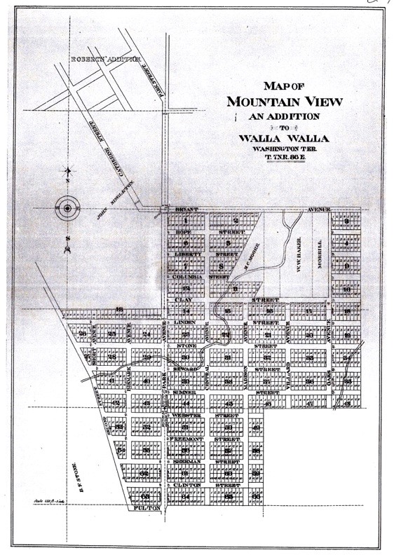
Plat Map of Mountain View Addition
The history of Mountain View Addition differs from other additions in that the plat map does not contain the name of any person(s) who may have had the land platted. Instead, the plat was dedicated on 4/7/1883 in a ceremony attended by the following prominent citizens of Walla Walla: Miles and Mary Moore (Miles Moore was the last governor of Washington Territory, whose imposing Victorian mansion is located on Bryant Avenue); D. W. and Ellen Small (David W. and Ira F. Small and a third brother, Albert, were New Englanders who arrived in Walla Walla in 1870, initially working for Dorsey Singh Baker, later launching the steamer Northwest on the Snake River in 1877. D. W. Small is the best remembered, having operated two opera houses with livery stables on the lower level in downtown Walla Walla. The first Small’s Opera House burned, but, undaunted, he built a second Small’s Opera House. His Second Empire style house at 313 Birch was designed by the town’s first prominent architect, F. P. Allen, in 1878 and cost $12,000. It was considered Walla Walla’s finest house); John and Viretta Bryant (the Bryants owned extensive property in the vicinity of Garrison Creek along what is now Bryant Avenue, from approximately Howard Street to Division Street); E. L. and Elizabeth Baumeister; John and Jane Singleton (the Singletons owned extensive property in various parts of Walla Walla, the largest parcel of which abutted the newly-platted Mountain View Addition); Max and Alvina Baumeister (Max Baumeister, born in Prussia, arrived in Walla Walla in 1862. He was prominent in the real estate and loan business, constructing the beautiful home that exists on Stone Street and Edwards Drive. The 1889 Max Baumeister Building at 27 West Main Street is on the National Register of Historic Places); Ira Small; W. W. (Walla Walla Willie) Baker; and G. A. Morrill. Despite the April dedication ceremony, it was noted that the public would not have access to the 66 blocks encompassing over 1,000 building lots or the streets until 10/1/1883. The plat map was filed 4/28/1883.
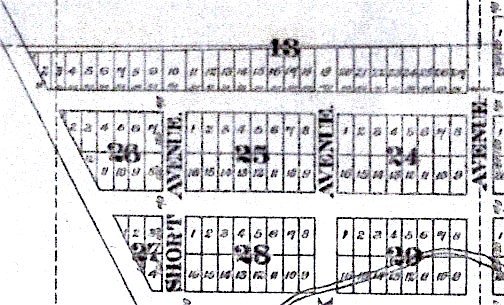
Plat Map detail showing Block 26
8/15/1876, Patent, U. S Government Land Office, Vancouver, W. T., grantor; Benjamin F. Stone and Thomas Munroe, grantees, undisclosed acreage in Section 29, Range 7 East, Township 36.
1/25/1883, Warranty Deed, Benjamin F. and Henrietta Stone, grantors; David W. Small, Ira F. Small, Maximilian Baumeister, Edward Baumeister and H. D. Chapman, grantees, 213.5 acres, in Sections 28, 32 and 33, Township 7, Range 36, $35,265.
2/2/1883, Warranty Deed, H. D. and Addie E. Chapman, grantors; Max Baumeister and Ira Small, grantors, portions of Sections 28, 29, 32 and 33, Township 7, Range 36, described as follows: “The following real estate, land and premises situated, lying and being in the County of Walla Walla and Territory of Washington and more particularly described as follows to wit, All their interest in and to that certain piece or parcel of Land in Sections 28, 29, 32 and 33, Township 7 North, Range 36 East conveyed by B. F. Stone and wife to D. W. Small and Ira F. Small, Maximilian Baumeister, Edward Baumeister and H. D. Chapman by deed dated January 24th 1883, which is hereby referred to and made a part of this conveyance. (Covenant) And they do covenant with the said Max Baumeister and Ira Small, and their legal representatives forever that their interest in the said real estate will – and their heirs, executors and administrators shall warrant – and defend the same to the said Max Baumeister and Ira Small their heirs and assigns forever against the lawful claims and demands of all persons whatsoever.” $2,000.
D. Chapman, dba Chapman & Boyer, maintained a real estate and insurance office in the Paine Building at 5 [South] 2nd Street. He also served as City and Deputy County Surveyor. 10/7/1885, Warranty Deed, Maximilian and Alvina Baumeister, grantors; D. W. Small and Edward Baumeister, grantees, portions of Sections 28, 29, 32 and 33, $1,000.
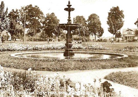
The Pioneer Park fountain in an early photograph. Oregon Historical Society.
2/6/1886, Warranty Deed, Maximilian and Alvina A. Baumeister, D. W. and Ellen Small, Ira and Alice Small, grantors; Ladies Relief Society of Walla Walla, W.T., grantee, Block 26 of Mountain View Addition, including the right to use water from street ditches, or if dry from the confluence of Garrison with Stone Creek, for irrigation, $550. What was behind this deed remains a mystery. The Ladies Relief Society was founded in 1881 with 60 members, who, it was noted in a 1989 Union-Bulletin article, were all listed under their husbands’ names. They furnished relief to many persons and families who were without the necessities of life. Today they are mainly remembered for having, in 1910, purchased and installed the iron fountain in what was then called City Park, now Pioneer Park. The fountain, commonly called the Wedding Fountain, presumably due to the many wedding photos taken in front of it, was actually dedicated to the children.
7/7/1886, Warranty Deed, D. W. and Ellen Small and Ira and Alice Small, grantors; Maximilian and Edward Baumeister, grantees, portion of Mountain View Addition including water rights, $5,000.
3/15/1907, Quit Claim Deed, Ladies Relief Society of Walla Walla, Washington, a corporation, grantor; R. M. Dorothy, E. A. Reser and C. M. Rader, Trustees under the Last Will & Testament of Joseph L. Stubblefield, deceased, Block 26 of Mountain View Addition “with all water rights appertaining and appurtenant thereto, “ $1. C. M. Rader was an attorney; E. A. Reser was a farmer; R. M. Dorothy does not appear in city directories.
11/4/1911, Indenture, Ladies Relief Society of Walla Walla, Washington, a corporation, grantor; Frank B. and Jennie B. Clark, grantees, Block 26 of Mountain View Addition, $10,000. Frank Clark was in partnership with Leslie Kirkman dba The Togs, a clothier at 11 West Main Street. The Clarks lived at 339 Whitman Street where they continued to reside during the entirety of their ownership of Block 26.
3/4/1912, Indenture, Frank B. and Jennie B. Clark, grantors; U. G. Bean, grantee, all of Block 26 of Mountain View Addition subject to a mortgage of $5,250 in favor of Peoples State Bank of Walla Walla, Washington, recorded on 11/10/1911. Ulysses Grant Bean, with four variously recorded birth dates, was probably born in 1864, as that is what is on his tombstone. He died in Walla Walla in 1927. He was first listed in the 1889 edition of the city directory, residing at 604 Washington Street. He owned U. G. Bean Furniture at 7 [South] 1st Street, formerly located at 14 East Main Street. He and his wife, Fannie, sometimes spelled Fanny, had four sons, one of whom, Glenn L. Bean (1896-1983), was a judge of the Superior Court for Walla Walla County.
In the 1912-13 edition of the Walla Walla city directory, Ulysses and Fannie Bean’s address is “h S 2d cor Linden.” which would be what is currently 1333 South 2nd Avenue. Linden was one block south of the then-city limits, between Stone and Clay Streets.
6/8/1915, Indenture, U. G. and Fannie Bean, grantors; James Gilkerson, grantee, all of Block 26 of Mountain View Addition, $3,000.
6/8/1915, Indenture, James and Anne P. Gilkerson of Cortland, New York, grantors; Fannie Bean, all of Block 26, $3,000.
4/18/1922, Statutory Warranty Deed, Fannie and U. G. Bean, grantors; Herman Neuner, a widower, grantee, all of Block 26, $10. Herman Neuner could not be located in any Walla Walla city directories, including county listings.
6/13/1922, Quit Claim Deed, Herman Neuner, a widower, grantor; Arthur G. Hall, as Trustee, all of Block 26, $1 and other valuable considerations.
6/22/1922, Agreement for Deed, John and Katie Weitzel, grantors; Arthur G. Hall, grantee, Block 26 of Mountain View Addition plus Lot 7, Block 5 of Elliott’s Addition, assuming a mortgage of $1,500. John Weitzel was a carpenter whose residence was listed as “h S 2d nr Stone RD3.” This would describe what is currently 1333 South 2nd Avenue.
7/22/1922, Warranty Deed, Martha Rabe, “a widow … when she acquired interest in this property,” grantor; John Weitzel, grantee, all of Block 26, free from all encumbrances except a mortgage in the amount of $1,500, $10.
8/11/1922, Deed, Herman Neuner, a widower, grantor; John Weitzel, Arthur G. Hall, Martha Rabe, grantees, all of Block 26 of Mountain View Addition, $10.
8/11/1922, Warranty Deed, Herman Neuner, a widower, grantor; John Weitzel, grantee, all of Block 26, $10.
8/11/1922, Agreement … between Herman Neuner of the first part, Arthur G. Hall of the second part and Martha Rabe of the third part … the first party has … conveyed to the second party as Trustee Block 26 of Mountain View Addition … together with certain personal property to be held by second party … subject … to the agreement … contained as to third party … that second party … shall have power … to sell the same for the support of the first party … it is … understood … that third party has during the past cared for first party and that she expects to do so hereafter … and [will] support first party … during the remainder of his life … second party will upon the death of first party convey to third party the land herein described … and should third party die before first party … she shall be entitled to receive … the value of said property … and such interest shall be paid to her estate …
9/20/1922, Quit Claim Deed, C. M. and Hattie Rader, E. A. and Della Reser, R. M. and Ella J. Dorothy, grantors; John Weitzel, Block 26, $10.
8/2/1938, Lis Pendens, The Baker-Boyer National Bank of Walla Walla, Washington, a corporation, plaintiff; v. Ed and Elma R. Weitzel and John and Katie Weitzel, defendants, a judgment on a promissory note for $1,648.92 with interest from 6/17/1938 @ 8% per annum, and attorney fees of $125, relative to Block 26.
8/2/1938, Writ of Attachment, plaintiff shall retain all property until plaintiff’s demands, as described in Lis Pendens, are satisfied.
12/20/1945, Warranty Deed, John and Katie Weitzel, grantors; Charles M. and Esther Ann Leid, grantees, “Beginning at a point in the West line of Block 26 of Mountain View Addition to the City of Walla Walla, Washington, said point being distant 151.34 feet South Easterly measured along the West line of said Block 26, from the North West corner thereof; thence South Easterly along the West line of said Block 26 a distance of 121.76 feet, more or less, to the South West corner thereof; thence East along the South line of said Block 26 a distance of 136.10 feet, to a point which is 60.0 feet Westerly, measured along the South line of said Block 26, from the South East corner thereof; thence North parallel to the East line of said Block 26 a distance of 160.0 feet, to a point in a line drawn parallel to and distant 80.0 feet Southerly measured at right angles from the North line of said Block 26 a distance of 56.5 feet; thence South parallel to the East line of said Block 26 a distance of 1.0 foot; thence South Westerly in a straight line a distance of 147.20 feet, more or less, to the point of beginning,” $5,000.
7/14/1964, Probate Release of Inheritance Tax Lien, in the Matter of the Estate of Charles M. Leid, deceased, No Probate Release of Inheritance Tax Lien.
10/4/1967, Statutory Warranty Deed, Esther Ann Leid, a widow, grantor; James R. and Margaret C. Reister, grantees, [same as current full legal description], $10 and other valuable considerations.
5/16/1973, Statutory Warranty Deed, Esther Ann Leid, a widow, grantor; Douglas and Cheryl Heimgartner, grantees, $10 and other valuable considerations.
5/16/1973, Quit Claim Deed, Esther Ann Leid, a widow, grantor; James R. and Margaret C. Reister, grantees, to clear title to property as described in the current full legal description.
2/28/1974, Quit Claim Deed, Cheryl Heimgartner, grantor; Douglas L. Heimgartner, grantee, $1.
9/30/2003, Quit Claim Deed, Patsy A. Heimgartner, grantor; Douglas L. Heimgartner, grantee.
2/4/2004, Statutory Warranty Deed, James R. and Margaret C. Reister, grantors under the Reister Living Trust; Mark S. Koonz, an unmarried person, as described: Parcel A: Beginning at the South West corner of Block 26 of Mountain View Addition to the City of Walla Walla, Washington, and running thence East, along the South line of said Block 26, a distance of 136.10 feet, to a point which is 60 feet West, measured along the said South line, from the South East corner of said Block 26; thence North, parallel to the East line of said Block 26, a distance [of] 110.0 feet to the true point of beginning of this description; thence South 69°12’ West 53.49 feet; thence North 64°22’ East 55.46 feet; thence South parallel to the East line of said Block 26, a distance of 5 feet to the true point of beginning; Parcel B: Beginning at the South West corner of Block 26 of Mountain View Addition to the City of Walla Walla, Washington, and running thence East, along the South line of said Block 26, a distance of 136.10 feet, o a point which is 60 feet West, measured along the said South line, from the South Easterly corner of said Block 26; thence North, parallel to the East line of said Block 26, a distance of 110.0 feet; thence South 69°12’ West 53.49 feet; thence South, parallel to the East line of the aforesaid Block, 41.0 feet; thence South Westerly in a straight line, 105 feet to a point in the Westerly line of the said Block 26, which point is 35.0 feet North Westerly, measured along the Westerly line of said Block 26, from the South West corner thereof; thence South Easterly, along the said Westerly line, 35.0 feet to the point of beginning, $10 and other valuable considerations. The address for Mark Koonz who continues to occupy the property and is pastor of Emmanuel Lutheran Church, is 11 Stone Street.
11/5/2015, Deed of Personal Representative, Gregory L. Heimgartner, Personal Representative of the Estate of Douglas L. Heimgartner, deceased, grantor; Gregory L. Heimgartner, grantee.
Construction of Building
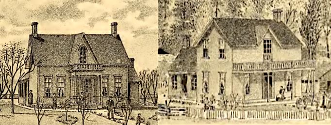
The exterior of 1333 2nd Avenue South might have appeared more like the above two simple houses when it was constructed. From Gilbert’s Historic Sketches of Historic Walla Walla County
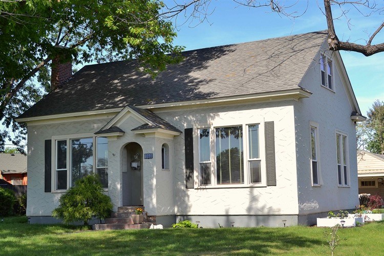
The Assessor’s 1930 build date for the house at 1333 South 2nd Avenue is considerably in error for the original structure, but could reasonably be considered a valid date for an extensive remodel to the structure. The current owner of the house reported that interior door hardware was manufactured prior to 1930. As noted above, Ulysses Grant Bean and Fannie Bean purchased all of Block 26 of Mountain View Addition on 3/4/1912, and they were listed in the 1912-13 city directory as residing at “h S 2d cor Linden” that being a common way of listing where a person lived if it was outside the city limits, as was 1333 South 2nd Avenue at that time. City of Walla Walla building permits exist as far back as September 1907; a search of all permits issued from that date through 1913 did not locate a building permit for the house, which was officially in Walla Walla County. Of the various early owners of Block 26, the 1912-13 listing for the Grants was the first for whom an address that is likely what is now 1333 South 2nd Avenue was included in city directories. Therefore, a build date of 1912 is proposed as a likely date that the original house was constructed for Ulysses and Fannie Grant and their children.
The house itself is a simple “saltbox” single gabled structure. Whether or not the extension to the back at the north side is original is unknown, and unfortunately there is no way to tell what the house looked like when built. The tall, narrow windows on the first floor hint to the earlier construction date. It’s possible that the attic was unfinished in 1912. Siding was probably clapboard, possibly with some type of ornamental shingles at the gables. It is certainly possible that there may have been a full-width front porch with turned posts; the current small gabled porch entrance certainly dates to the remodel, as does the swirled stucco concrete siding.
Resources
- Pioneer/Columbia Title
- Whitman Archives
- Sanborn Fire Maps, 1889, 1890, 1894, 1905 with alternations through 1945)
- Walla Walla City Directories, various years
- Walla Walla County Auditor
- Bennett, Robert A., Walla Walla: a Town Built To Be a City, 1900-1919, Pioneer Press Books, 1982
- Walla Walla Union-Bulletin, 2/26/1989
- Walla Walla Valley, W.T., Statesman Book and Job Press, Walla Walla 1879, courtesy Joe Drazan’s Bygone Walla Walla blog
- www.rootsweb.com
- www.billiongraves.com


