History of 389 South Palouse Street, Walla Walla, WA
Legal Description
Roberts’ Tax 2, Block 7
Full Legal Description
Beginning at the monument locating the point of intersection of the center line of Newell Street with the center line of Palouse Street in Roberts’ Addition to the City of Walla Walla, Washington, according to the official plat thereof in the office of the Auditor of Walla Walla County, Washington; thence North 29° 50’ West and along said center line of Palouse Street 140 feet; thence North 60° 10’ East 40 feet to the true point of beginning for this description (said true point of beginning being the point of intersection of the Southerly line of Lots 5 and 6 in Block 6 of said Roberts’ Addition with the Easterly line of said Palouse Street); from said true point of beginning run thence North 60° 10’ East and along said Southerly line of Lots 5 and 6 aforesaid, 100 feet; thence North 29° 50’ West 50 feet; thence South 60° 10’ West 100 feet; thence South 29° 50’ East 50 feet to said true point of beginning; said tract being commonly known as the Southerly half of said Lots 5 and 6 in Block 7 of Roberts’ Addition to the City of Walla Walla.
Title and Occupant History
Washington Territory was created in 1853. In 1854, the new territorial legislature created Walla Walla County, which stretched from the crest of the Cascade Mountains to the crest of the Rocky Mountains in the present states of Washington, Idaho and Montana. In 1855, Isaac Stevens, governor of Washington Territory, held a council on the banks of Mill Creek at the present site of Walla Walla with representatives of regional Indian tribes to purchase land from them. The Yakamas, Cayuses and Walla Wallas were dissatisfied with the treaties and the intrusion by whites into their lands before the treaties’ ratification, and war followed. Missionaries, former French-Canadian employees of the Hudson Bay Company trading post at Wallula, and soldiers at the military Fort Walla Walla were the primary European occupants of the area prior to 1859, when the treaties were finally ratified and the land was opened for settlement. The transfer of ownership occurred by virtue of a treaty signed on June 9, 1855 in Walla Walla and ratified on March 8, 1859 by President James Buchanan, in which all of the land in the Walla Walla area was acquired from the Cayuse and Walla Walla Indian tribes.
The town of Walla Walla was originally laid out by County Surveyor Hamet Hubbard Case in 1859, prior to its formal incorporation as a city in 1862, as a one-quarter mile square with its eastern side centered on the point where Main Street crossed Mill Creek (at roughly the point where it does now). The original plat was lost, probably in the fire of 1865. Thus, the earliest plat on file is one made by W. W. Johnson, City Surveyor, in July 1865 that claims to have made corrections to Case’s survey. Johnson’s survey was made the official plat of the City of Walla Walla on September 25, 1866, was filed and recorded July 5, 1867.
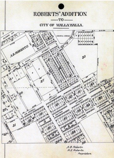
Plat Map of Roberts’ Addition.
A. B. Roberts and his wife, Martha, left Portland, Oregon. in 1859, traveling upriver to The Dalles, and eventually by land on to Wallula, W.T. From there they ventured on to Fort Walla Walla, at that time located along what is now East Main Street east of 1st, where Roberts determined to remain, purchasing property from Tom Hughes near the current northeast corner of 1st and Alder Street for $250. He constructed a house of canvas and poles about 150 feet south of that corner. He fenced in additional land around his rudimentary house and held it until the small town was surveyed. Roberts was one of 42 men selected to run for city office in 1862 in an effort to curb crime in Walla Walla; it appears he was neither elected nor appointed to office.
Eventually A. B. and Martha Roberts extended their holdings, including acreage granted by the United States Government under the homestead act that ranged from approximately First Street on the west to approximately Howard Street on the east, and from approximately L Street on the south to Alder Street to the north. Platted in 1870, the land was recorded January 20, 1871 as Roberts’ Addition to the City of Walla Walla. (See illustration of plat map on Page 2.
8/31/1871, Warranty Deed, A. B. and Martha E. Roberts, grantors; A. R. Fay, grantee Lots 1-8, Block 7, $500.
3/9/1874, Warranty Deed, Fay, Albert and Nancy, grantors; Ellen Garlington, grantee, Lots 3-7, Block 7, $200.
10/5/1882, Warranty Deed, John J. and Ellen Garlington, grantors; Thomas Swezea, Lots 3-7, Block 7, $3,000.
4/20/1889, Warranty Deed, Smith W. Swezea, son of Thomas Swezea, deceased grantor; Missouri A. Wightman, grantee, Lots 3-6, Block 7, $250.
4/20/1889, Warranty Deed, Charles L. Swezea, grantor; Missouri A. Wightman, grantee, one-half ownership Lots 3-6, Block 7, $250
7/3/1889, Nancy Jane Hager of Oakland, CA, “heir at law of of Lucinda Swezea, deceased,” grantor; Missouri A. Wightman, grantee, one-half ownership Lots 3-6, Block 7, $385 in gold coin.
(The three above grantors were among the twelve children of Thomas Swezea, deceased.)
12/11/1890, Warranty Deed, James W. and Elizabeth A. Swezea, grantors; Lucinda Swezea, grantee, one-half ownership Lots 3-6, Block 7, $300.
3/6/1894, Indenture, Missouri A. Wightman, a widow, grantor; Lucinda Swezea, grantee, one-half ownership Lots 3-6, Block 7, $250. This appears to have been a mortgage.
8/4/1898, Warranty Deed, Jay Swezea, Sadie Russell, Viola Hamilton, heirs of Thomas J. Swezea, deceased, grantors; Missouri A. Wightman, grantee, Lots 3-6, Block 7, $250.
4/16/1900, Warranty Deed, Ellen and James Clancy, grantors; William Clancy, grantee, “1/2 of Lots 5 and 6, Block 7, $1,600”. Ellen and James Clancy appear to have acquired an interest in the north half of Lots 5 and 6, perhaps in connection with an assignment of the mortgage conveyed by Missouri Wightman, and to have constructed a house there which they sold to their son William
7/19/1905, Quit Claim Deed, William Clancy, unmarried, Ellen and James Clancy, grantors; Missouri A. Wightman, grantee, $5. As the 1905 Sanborn Fire Map shows a home on the north half of Lots 5 and 6, this deed cleared any apparent Clancy claim to the south half of those lots in connection with the simultaneous deed from Wightman to Tiderington detailed below.
7/19/1905, Warranty Deed, Missouri A. Wightman, a widow, grantor; Archibald Tiderington, grantee, “the southerly one-half of Lots 5 and 6 in Block 7,” $900. This is the first recorded transaction that includes the specific portions of the two lots on which the house was built. It included a 50-foot frontage and 100-foot depth.
6/18/1908, Quit Claim Deed, Carlotta Luella Tiderington, grantor; Archibald Tiderington, her husband, $1 for love and affection.
11/9/1911, Deed, Archibald Tiderington, unmarried, grantor; Campbell Robinson, grantee, $2,500.
11/13/1912, Indenture, Grant Copeland, trustee of the estate of Archibald Tiderington, bankrupt, grantor; Campbell Robison, grantee, $100.
3/4/1916, Indenture, Harry H. Robinson, a bachelor, and Myrtle V. Robinson, a spinster, grantors; Sarah M. Lorton, $1 and other valuable considerations.
2/20/1923, Warranty Deed, Sarah M. Lorton, a window, grantor; Ellen Cloutier, a widow, grantee, “part of” Lots 5 and 6, Block 7, $1 and other valuable considerations.
9/4/1924, Lis Pendens, Sarah M. Lorton, plaintiff v. Ellen Cloutier and Prudential Mutual Insurance Company, for foreclosure involving $3,186.33 @ 8% per annum, attorney fees and court costs.
11/25/1924, Quit Claim Deed, Harry H. Robinson, devisee under the Last Will and Testament of Campbell Robinson, grantor; C. R. Baker, grantee, $1.
11/25/1924, Quit Claim Deed, Myrtle V. Howard, formerly Robinson, grantor, C. R. Baker, grantee, $1.
11/25/1924, Quit Claim Deed, Missouri A. Frazier, formerly Wightman, grantor; C. R. Baker, grantee, $1.
11/25/1924, Quit Claim Deed, Ellen Cloutier, a widow, grantor; C. R. and Florence C. Baker, grantees, $1.
12/6/1924, Warranty Deed, C. R. and Florence C. Baker, grantors; L. L. Davison, grantee, $1 and other valuable considerations.
12/11/1924, Lis Pendens, L. L. and Mary M. Davison v. T. R. and Jane Doe Tannant, Archibald Tiderington “and any unknown heirs of the above and any unknown heirs of Lucinda Swezea, deceased, and all parties unknown claiming any right…”
5/9/1941, Affidavit, Missouri Frazier to The Public, states that she is the daughter of Thomas Swezea, deceased, married to Cantrell Frazier, deceased.
5/29/1957, Quit Claim Deed, L. L. Davison, a widower, grantor; Glenn E., Frank L. and Dorothy A. Davison, grantees, for love and affection to his children.
10/21/1968, Quit Claim Deed, Callie Pearl Davison, representing the estate of Frank Lawrence Davison, deceased; grantor; Glenn E. and Dorothy A. Davison, grantees.
8/10/1972, Statutory Warranty Deed, Dorothy A. Davison, a single woman, grantor; Glenn E. and Rosetta R. Davison, grantees, $10.
8/16/1974, Quit Claim Deed, John L. and Mary E. Howard, grantors; Harrel C. and Shirley A. Higgenbotham, grantees, $1.
5/5/1975, Statutory Warranty Deed, Harral C. and Shirley A. Higgenbotham, grantors; William A., Jr. and Betty Simcox, $10 and other valuable considerations.
6/12/1991, Statutory Warranty Deed, William A. and Betty R. Simcox, grantors; John Luscher, unmarried, $10 and other valuable considerations.
12/18/2002, Statutory Warranty Deed, John W. Luscher, an unmarried individual, grantor; Anthony G. and Esther L. Dobrin, trustees of Dobrin Family Trust.
1/2/2003, Quit Claim Deed, Anthony G. and Esther Dobrin, trustees of Dobrin Family Trust, grantors; Anthony and Esther Dobrin, grantees.
7/13/2015, Statutory Warranty Deed, Esther L. Dobrin, a widow, grantor; Rachel L. George and John E. Gahbauer, grantees, $283,818.00
4/5/2018, Statutory Warranty Deed, John E. Gahbauer, grantor; Steven and Marlene Wallis, grantees.
Construction of Building
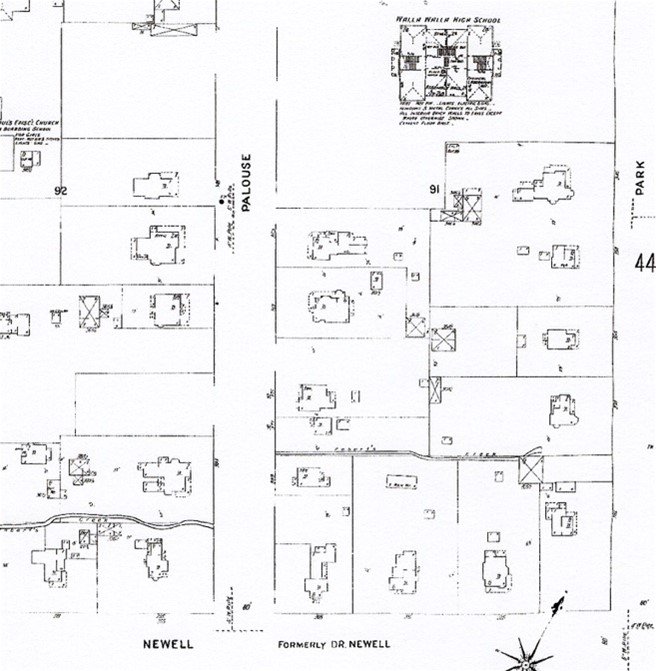
The first edition of the 1905 Sanborn Fire Map does not contain the house at 389 South Palouse Street.
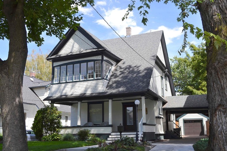
The Assessor’s Office lists 1906 as the build date for 389 South Palouse Street. This is a reasonably accurate construction date. The widow Missouri Wightman sold “the southerly one-half of Lots 5 and 6 in Block 7” for $900 on 7/19/1905 to Archibald Tiderington, harness maker, with a shop at 126 East Main Street. The first edition of the 1905 Sanborn Fire Map does not show the house. However, the 1906 city directory lists Mr. Tiderington as residing at 389 South Palouse. He sold the property in 1911 for $2,500, a considerable increase in the value of the property, cementing the fact that the house was possibly begun in late 1905, and completed in 1906.
The house is two and one-half stories, the ground floor clapboard-sided and the upper floor and attic level finished in simple shingles. It would be described as craftsman style. The roof, with a simple side-to-side main gable, has an unusually steep pitch. A large second gable projects from the left side of the second story and was most likely originally a screened sleeping porch. Currently, it is enclosed with multi-pane windows, the effect an attractive one, adding character to the house. A full-width porch supported by four square posts, with offset front door, is wrapped into rather than projected from the house.
Resources
- TitleOne (formerly Pioneer Title)
- Walla Walla County Auditor’s Vault indexes of recorded deeds
- Gilbert, Frank T., Historic Sketches of Walla Walla, Whitman, Columbia and Garfield Counties, W.T. and Umatilla County, Oregon, Portland, Oregon, 1882
- Bennett, Robert A., Walla Walla: Portrait of a Western Town, 1804-1899, Pioneer Press, 1980
- Walla Walla city directories (various)
- Sanborn Fire Maps (1905)


