
US Highway 730: a disaster waiting to happen
Editor’s Note: This article also appears on the Walla Walla Union Bulletin website: Slow drivers down on U.S. Highway 730 for the safety of all people visiting local attractions
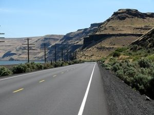
Looking east on US 730 as it travels along Lake Wallula in Oregon, approaching the state border with Washington
Along the two-lane highway leading southeast from Wallula is one of Walla Walla County’s most popular areas for recreation and nature study. The speed limit for the Washington portion of this highway that winds through Wallula Gap is 60 mph; with the speed limit rarely if ever enforced there, many vehicles travel at 70 mph (the speed limit for the straighter Oregon portion of US 730 is 55 mph). We request that county commissioners and our state senator and representative asked the Washington Department of Transportation to give the Washington portion of US 730 a special designation (a recreational area?) and to reduce the speed limit to 45 mph.
The speed limit at Wallula Junction is 45 mph. Traveling southwest toward Oregon are the following places frequented by individuals and groups for recreation, photography, natural history, fishing, and exercise:
- A small pullout on the right used by fishermen, and by scientists to study the best exposure of the fault along the Olympic-Wallowa lineament, which stretches northwest across Washington from northeastern Oregon to the Strait of Juan de Fuca.
- A parking lot on the left by a sign with information on the natural and human history of this area. From here two paths lead uphill to miles of biking and hiking trails with spectacular views in all directions.
- A tiny, blind (because it is on the inside of a curve with cliffs in both directions) parking space at the Walla Walla County Park featuring the Two Sisters, sacred to Native Americans. A trail leads up to the buttes and sand dunes. This area is quite popular for picnics, field trips, hikers, nature lovers, and families; children love to play in the dunes.
- A parking shoulder on the right for rock climbers and hikers. This is the closest rock climbing area to Walla Walla and the Tri-Cities; on some weekends dozens of vehicles are parked here. The cliffs for climbing are on the left, necessitating highway crossings by pedestrians.
- On the right is the marina of the Walla Walla Yacht Club. Vehicles pull boat trailers to and from the launching ramp.
- Just beyond the marina is one of the facilities of Northwest Grain Growers, which at certain times of the year has lots of truck traffic. Informal discussion with Northwest Grain Growers indicates that they have no objection to reducing the speed limit.
- On the left at the mouth of Spring Gulch is a popular natural history stop because of an outcrop of Mazama ash from the eruption at Crater Lake 7700 years ago, a native plant seedbed on the alluvial fan, a peregrine falcon nest, and nests of white-throated swifts.
All of Wallula Gap, particularly the southeast side along Highway 730, is of particular value for Native American history, and for winter habitat for mule deer and bighorn sheep. This is also the only nearby location for certain species of desert butterflies.
We urge the Washington Department of Transportation to reduce the speed limit on US 730 to 45 mph for the for safety of those who play, study, exercise, and work there.
Bob Carson
705 Boyer
Walla Walla, Washington 99362
509-520-7647
Mike Denny
1354 SE Central Ave.
College Place, Washington 99324
509-240-5552


