
History of 429 East Sumach Street, Walla Walla, WA
Legal Description
Lot 10 in Block 10 of Cain’s Addition to the City of Walla Walla, according to the official plat thereof of record in the office of the Auditor of Walla Walla County, Washington in Book “A” of Plats, on Page 41.
Title and Occupant History
Washington Territory was created in 1853. In 1854, the new territorial legislature created Walla Walla County, which stretched from the crest of the Cascade Mountains to the crest of the Rocky Mountains in the present states of Washington, Idaho and Montana. In 1855, Isaac Stevens, governor of Washington Territory, held a council on the banks of Mill Creek at the present site of Walla Walla with representatives of regional Indian tribes to purchase land from them. The Yakamas, Cayuses and Walla Wallas were dissatisfied with the treaties and the intrusion by whites into their lands before the treaties’ ratification, and war followed. Missionaries, former French-Canadian employees of the Hudson Bay Company trading post at Wallula, and soldiers at the military Fort Walla Walla were the primary European occupants of the area prior to 1859, when the treaties were finally ratified and the land was opened for settlement. The transfer of ownership occurred by virtue of a treaty signed on June 9, 1855 in Walla Walla and ratified on March 8, 1859 by President James Buchanan, in which all of the land in the Walla Walla area was acquired from the Cayuse and Walla Walla Indian tribes.
The town of Walla Walla was originally laid out by County Surveyor Hamet Hubbard Case in 1859, prior to its formal incorporation as a city in 1862, as a one-quarter mile square with its eastern side centered on the point where Main Street crossed Mill Creek (at roughly the point where it does now). The original plat was lost, probably in the fire of 1865. Thus, the earliest plat on file is one made by W. W. Johnson, City Surveyor, in July 1865 that claims to have made corrections to Case’s survey. Johnson’s survey was made the official plat of the City of Walla Walla on September 25, 1866, was filed and recorded July 5, 1867. Andrew. J. Cain was a lawyer in Walla Walla between 1860 and 1873, and an early financier of both the Walla Walla Union newspaper and the Walla Walla Statesman newspaper. On September 10, 1861, A. J. Cain and Cornelius Kelly filed a claim through the Olympia, W.T. Land Office for 160 acres in Section 20, Township 7-North, Range 36-East under the Scrip Warrant Act of 1855. Cain was elected on the Democratic ticket as prosecuting attorney of Walla Walla County in 1868. Although defeated in 1870, District Court Judge James Kennedy ruled that Cain could complete his full two-year term, thus denying the winner, N. J. Caton, his right to occupy the office until 1871.

Plat map of Cain’s Addition to the City of Walla Walla
Cain’s Addition to the City of Walla Walla was recorded in Volume A of plats on Page 41 January 31, 1874. As noted on the Dedication, “We D. S. Baker and Elisabeth H. Baker of the City and County of Walla Walla, do on this 17th day of January A.D. 1874, dedicated to public use the streets and alleys set forth in the above plat of the S.W. ¼ of N.E. ¼; N.W. ¼ of S.E. ¼; N.E. ¼ of S.W. ¼ and S.E. ¼ of N.W. ¼ of Sec. No. 20, T.T.N.R. 36E and named Cain’s Addition to the City of Walla Walla: reserving the sole and exclusive right to lay water pipes, gas pipes and other and all conductors through the said streets and alleys or any part thereof.” Also, “Main, Rose and Sumach Streets in Cain’s Addition to the City of Walla Walla are extensions of the named streets in Walla Walla City proper, having the same width, and whereas the blocks lying between said streets on survey are found to be large, therefore the excess of ground is platted in the alleys.” Cain later moved to Dayton and in September 1874 began publication of the Dayton News, a weekly Democratic newspaper. He became known as the “Father of Columbia County” as a result of his leading role in the formation of that county.
2/14/1862, Deed, A. J. and Emma R. Cain, grantors; A. H. Reynolds, grantee, the Southwest quarter of the Northeast quarter, the Southeast quarter of the Northwest quarter, the Northwest quarter of the Southeast quarter and the Northeast quarter of the Southwest quarter of Section 20, Range 7, Township 36, with the exception of building sites already occupied by Mssrs. Way and Bush, George E. Cole, James McAuliff and Dr. Danforth, additionally numerous specified building lots, $1,000.
11/18/1867, Sheriff’s Deed, A. Seitel, Sheriff of Walla Walla County to Dorsey S. Baker, to recover $7,320.56 damages secured by a mortgage and lien against A. J. and E R. Cain.
10/20/1871, Deed, Andrew J. and Emma R. Cain, grantors; Dorsey S. Baker, grantee, same as described in deed of 2/14/1862 except Blocks A. B. C, D, 1 through 6 and 40 and Lots 6 and 7 in Block 7, $1.
3/31/1885, Deed and Quit Claim Deed, John F. and Sarah E. Boyer, grantors; Dorsey S. Baker, grantee, to release property acquired jointly by Boyer and Baker known as Cain’s Addition, specifying that Boyer may enjoy the waters of a certain spring, brook or branch of Mill Creek, $1.
6/30/1890, Deed, Miles Moore, Edwin Baker, Henry Baker and Walla Walla Willie Baker, executors of the Last Will & Testament of Dorsey S. Baker, deceased, grantors; H. J. Cozine, grantee, Lots 9 and 10, Block 10 of Cain’s Addition, $450. H. J. Cozine was a professor at Whitman College; Mrs. Cozine was a matron at the college.
7/1/1890, Warranty Deed, H. J. and Lilian Cozine, grantors; Michael McCarthy, grantee, Lots 9 and 10, Block 10, $900. Michael McCarthy was the manager of Small’s Livery Stable.
7/11/1891, Warranty Deed, Michael McCarthy, grantor; James Madison Cornwell, grantee, Lots 9 and 10, Block 10, $1,150. J. M. Cornwell was a farmer. The 1892 Walla Walla City Directory lists him in residence at 469 East Sumach Street.
9/17/1901, Warranty Deed, Oliver T. Cornwell, Laura F. Robinson, Charles E. Cornwell, Nannie E. Cation, Arthur G. Cornwell and Minnie A. Cornwell, heirs at law of James M. and Mary A. Cornwell, deceased, grantors; Campbell Robinson, grantee, Lots 9 and 10, Block 10, $3,800. Campbell Robinson was a farmer and resident of Waitsburg in 1901. In 1902 he resided at 429 East Sumach Street.
8/26/1907, Quit Claim Deed, Nancey E. Robinson, grantor; Campbell Robinson, grantee, Lots 9 and 10, Block 10, and properties in California, $1.
4/11/1927, Deed, Lillian M., Myrtle V. Harry H. Samuel E. Charles D and Frank C Robinson, devisees under the Last Will & Testament of Campbell Robinson, deceased, grantors; Mervin P. O’Rourke, a single man, grantee, Lots 9 and 10, Block 10, $1 and other valuable consideration. O’Rourke was a plumber employed by his father’s shop, W. R. O’Rourke Plumbing & Heating, The O’Rourkes were listed in the 1929-30 city directory residing at 429 East Sumach Street.
2/19/1932, Lis Pendens, Wilda O’Rourke v. Mervin P. O’Rourke, to obtain a divorce and property settlement involving Lots 9 and 10, Block 10.
8/27/1936, Warranty Deed, Mervin P. O’Rourke, a widower, grantor; W. R. and Alicie O’Rourke, grantees, Lots 9 and 10, $10 and other valuable consideration.
10/29/1938, Quit Claim Deed, W. R. and Alicie O’Rourke, grantors; Mervin P. and Viola O’Rourke, grantees, Lot 9, Block 10. This quit claim deed marks the separation of Lot 9 from Lot 10.
8/16/1960, Bargain and Sale Deed, Seattle-First National Bank, as executor of the estate of William R. O’Rourke, deceased, grantor; Jean O’Rourke, a widow, grantee, the remaining one- half interest in Lot 10, Block 10, $8,750. Sometime between 1936 and 1960 it appears that the O’Rourke family disposed of Lot 9. There are no missing deeds or other documents concerning a sale or transfer of Lot 9. Thus, it may have been an unrecorded gift.
9/22/1965, Contract of Sale, Jean O’Rourke, a widow, grantor; Jack K. and Gladys R. Pannell, grantees, Lot 10, Block 10, $10 and other valuable consideration. Jack Pannell was the recreation director for the Elk’s Club. By this time 429 East Sumach Street had been converted to four apartments. (This will be discussed under Construction of Building.) The Pannells did not reside on premises.
7/12/1966, Purchaser’s Assignment of Contract and Deed, Jack K. and Gladys R. Pannell, grantors; Donald G. and Shirley M. Mader, grantees. The Maders could not be found in city directories.
8/31/1966, Quit Claim Deed, Donald G. Mader, grantor; Shirley M. Mader, grantee, Lot 10, Block 10, $1.
6/9/1972, Sale Agreement, Shirley M. Mader, an unmarried woman, grantor; Wayne F. and Myrna J. Helgeson, grantees, the house on Lot 10 of Block 10 and all furniture included, $15,600, purchaser to pay $13,079.20 on the prior contract of 7/12/1966. Also same date, Statutory Warranty Deed, Shirley M. Mader, an unmarried woman, grantor; Wayne F. and Myrna J. Helgeson, grantors, $10 and other valuable consideration subject to 1972 taxes and an unrecorded contract of sale of 9/22/1965. Mr. Helgeson was a corrections officer at the Washington State Penitentiary and the Helgesons resided in Unit 1 of the O’Rourke Apartments.
12/18/2009, Affidavit, [Estate of] Wayne F. Helgeson, deceased, grantor; Myrna J. Helgeson, grantee, Lot 10, Block 10.
12/31/2012, Warranty Deed, Myrna J. Helgeson, grantor; Fred O., Jr. and Lisa Zack, grantees, Lot 10, Block 10, $213,000.
3/22/2013, Change in Residential Occupancy, Fred and Lisa Zack as owners of Lot 10, Block 10, to the City of Walla Walla: “We purchased home in January as our residence and will not be renting out any rooms. We have switched/removed all elec. Meters and installed a single electrical panel.”
8/19/2014, Statutory Warranty Deed, Fred O., Jr. and Lisa Zack, grantors; Estate of Mary McCaw, grantee, $260,000.
6/24/2016, Special Warranty Deed, Estate of Mary McCaw, grantor; Mark C. McPherson, grantee, Lot 10, Block 10, $278,850.
10/19/2022, Statutory Warranty Deed, Mack C. McPherson, grantor; Kirkland A. and Kristin M. Stewart, grantees, Lot 10, Block 10.
Construction of Building

Left: the 1894 Sanborn Fire Insurance Map showing the original footprint of 429 East Sumach Street. Right: it was not until 1905 that a new Sanborn map was published in which the modifications to 429 East Sumach Street are apparent.
429 East Sumach Street has been a most interesting home to research. While the documents by which the history of the house or building can be traced are intact so far as could be determined, in some cases they do not reveal all the information and additional research was needed, e.g., a separate search of deeds in the folder for Lot 9 to determine when it was separated from Lot 10. Also are the year in which the original house was expanded to its present configuration that could not be determined.
City of Walla Walla building permits are preserved at Whitman College Archives as early as mid-September 1907. The County Assessor gives a build date of 1906 to 429 East Sumach Street. Their dates are usually estimates based on the structure’s appearance. However, in fact the house appears to have been constructed by James M. and Mary Cornwell who purchased Lots 9 and 10 of Block 10 on July 11, 1891 from Michael McCarthy for $1,150, not much more than McCarthy paid for the property from the Cozines, and who sold the property in 1901 for $3,800.
Construction probably began in 1891 and may well have been completed that year. What the Assessor’s Office might not have known is that the house had been updated and slightly enlarged.
That date could not be determined, but it was done before 1905, hence the estimated build date. The first appearance of the house on a Sanborn Fire Insurance Company map was the 1894 edition (Sanborn maps were not published every year). Compare the footprint of the 1894 house with the footprint that appears on the next published Sanborn map of 1905. The house has had a slight extension made on the northwest corner and the large wrap-around front porch has been added.
Regrettably, no photograph of the house showing its original form could be located.
In his second volume of the history of Walla Walla, Prof. W. D. Lyman devotes considerable space to James Madison Cornwell. Cornwell was born in Indiana in 1834, one of eight sons to parents who were farmers. The father moved the family to Illinois when James was five. His education was described as typical for a farmboy of that era. At age 17, James and his older brother Francis, age 19, started on foot for the Pacific Coast. At St. Joseph they found employment as teamsters on a train bound for Oregon. It was an arduous journey. Reaching Boise, the brothers set out on foot for The Dalles with almost no provisions and no food. En route, they bought a rotten salmon from a native fisherman and ate it, so hungry were they. James eventually took up farming near Portland; Francis had lost his health on the journey west and died in 1858, age 26.
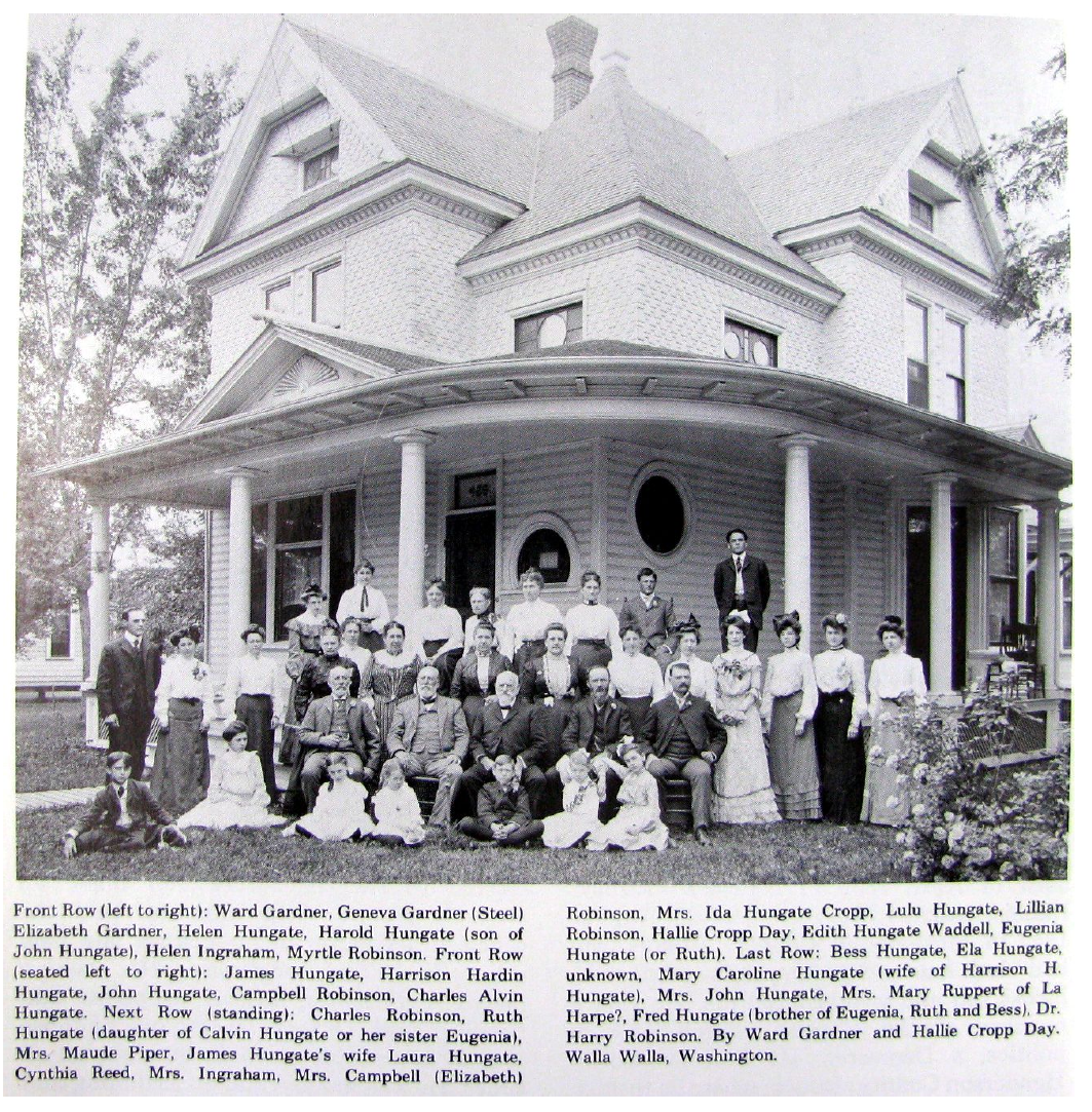
This undated photograph is posted on the Bygone Walla Walla blog. While the relationship of all persons in the photo is not known, Campbell Robinson (fourth from left in the front row seated) was married to the Cornwells’ daughter Laura.
It could not be determined for certain how the prominent Hungate family of Walla Walla was related to either the Cornwells or the Robinsons. Patriarch Harrison Hardin Hungate is second from left in the row of seated men. Courtesy Joe Drazan.
In 1861, James Cornwell sold his property in Oregon and headed to the mines in Orofino, Idaho. He also filed a claim on a ranch on Dry Creek north of Walla Walla, where he settled after a brief stay in Idaho. The first winter on Dry Creek was hard and long, and he lost most of his cattle. James had married Mary Tucker in 1857; she died two years later, and he married Mary Scott, with whom he had seven children. Mrs. Cornwell died in 1893; her husband followed her in 1899. Both are buried in Mountain View Cemetery, along with several of their children.
James Cornwell served in the Territorial Legislature as a representative of both Walla Walla and Whitman Counties, where he was considered a valuable member with vast knowledge concerning the management of farm properties.
As mentioned, the original appearance of two and one-half story house cannot be determined due to the evident lack of an early photograph. In the historic photo on Page 5 we see a modified Queen Anne style house that presumably was more elaborately embellished in its original form. What appears to be clapboard siding clads the main level, with fishscale shingles at the second level. The wrap-around front and side porch is in place, supported by simple round posts, very common of Walla Walla houses of the time. The roof is complex, with both front and side gables, each of which contains a fan or sunburst motif at the peak. A shallow pediment above the front steps also contained a fan or sunburst motif, since hidden under new siding or removed. Likely the most interesting and baffling decorative features are the two-thirds round window to the right of the front door and the full round window around the corner on the east side. One wonders what prompted these unusual fixtures to be incorporated in the design. On the second level above these two windows and at the third level of the front and side gables windows with what appears to be stained glass can be seen in the older photo. These, too, have been replaced with plain glass. While many of the ornamental features on display in the group photo are extant, all the siding has been replaced.
As noted above, in 1927, Robinson family heirs sold the property to Mervin P. O’Rourke, at the time a single man and a plumber, employed at his father’s company, O’Rourke Plumbing & Heating. However, before 1932 he had married Wilda, and in that year Wilda filed for divorce from him. The house remained in the O’Rourke family for 38 years until 1965.
The 1926-27 city directory discloses that the house was owner occupied. However, the 1929-30 directory lists the property as O’Rourke Apartments, containing four units. 429 East Sumach Street remained apartments until its sale on 12/31/2012 to Fred O. and Lisa Zack, who returned the house to single occupancy status.
Resources
- Pioneer/Columbia Title
- Whitman Archives
- Walla Walla County Auditor’s online property search
- Sanborn Fire Maps, 1894 and 1905
- City Directories, various years
- Lyman, Prof. William Dennison, Lyman’s History of Old Walla Walla County embracing Walla Walla, Columbia, Garfield and Asotin Counties, Vol. 2, The S. J. Clarke Publishing Company, Chicago, 1918
- Pam Ransier, Administrative Permit Coordinator, City of Walla Walla Development Services


