History of 428 Craig Street, Walla Walla, WA

Legal Description
Beginning at the Northwest corner of Lot 1 in Block 22 of Roberts’ Addition to the City of Walla Walla, according to the official plat of record in the office of the Auditor of Walla Walla County, Washington, in Book A of Plats at page 21, and running thence Southeasterly along the Westerly line of said Lot 1 a distance of 120 feet; thence Northeasterly parallel to the Southerly line of Craig Street, to the West line of Howard Street, as said Howard Street is now used and established; thence North 00° 16’ East, along said West line of Howard Street, to the point of intersection of said West line of Howard Street with the Southerly line of Craig Street; thence South 60° 10’ West, along said Southerly line of Craig Street, a distance of 110.15 feet to the point of beginning. Being a part of Block “J” and the Northerly 120 feet of Lot 1 in Block 22 of said Roberts’ Addition.
Title and Occupant History
Washington Territory was created in 1853. In 1854, the new territorial legislature created Walla Walla County, which stretched from the crest of the Cascade Mountains to the crest of the Rocky Mountains in the present states of Washington, Idaho and Montana. In 1855, Isaac Stevens, governor of Washington Territory, held a council on the banks of Mill Creek at the present site of Walla Walla with representatives of regional Indian tribes to purchase land from them. The Yakamas, Cayuses and Walla Wallas were dissatisfied with the treaties and the intrusion by whites into their lands before the treaties’ ratification, and war followed. Missionaries, former French-Canadian employees of the Hudson Bay Company trading post at Wallula, and soldiers at the military Fort Walla Walla were the primary European occupants of the area prior to 1859, when the treaties were finally ratified, and the land was opened for settlement. The transfer of ownership occurred by virtue of a treaty signed on June 9, 1855, in Walla Walla and ratified on March 8, 1859 by President James Buchanan, in which all of the land in the Walla Walla area was acquired from the Cayuse and Walla Walla Indian tribes.
The town of Walla Walla was originally laid out by County Surveyor Hamet Hubbard Case in 1859, prior to its formal incorporation as a city in 1862, as a one-quarter mile square with its eastern side centered on the point where Main Street crossed Mill Creek (at roughly the point where it does now). The original plat was lost, probably in the fire of 1865. Thus, the earliest plat on file is one made by W. W. Johnson, City Surveyor, in July 1865 that claims to have made corrections to Case’s survey. Johnson’s survey was made the official plat of the City of Walla Walla on September 25, 1866, was filed and recorded July 5, 1867.
A.B. (Alvin Brown) Roberts was born May 17, 1832, in Knox Township, Jefferson County, Ohio. He arrived in Oregon Territory in 1853 and settled in Portland where he established the stone cutting firm of Roberts and Hartle. He served in Company A, Multnomah County, First Regiment from October 13 to December 19, 1855, in what was known as the Yakima War. He fought in what became known as the Battle of Walla Walla from December 7-11, 1855.
After his military service, Roberts went back to marble-cutting in Boise City, Idaho. On September 15, 1858 Roberts married Martha Elizabeth Baxter in Clackamas County, Oregon. (They divorced in 1866.)
A.B. Roberts and Martha left Portland, Oregon in 1859, traveling upriver to The Dalles, and eventually by land on to Wallula, W.T. From there they ventured on to the military Fort Walla Walla, at that time located along what is now East Main Street east of First, where Roberts determined to remain, purchasing property from Tom Hughes near the current northeast corner of South 1st and Alder Street for $250, which amounted to about 160 acres. He constructed a house of canvas and poles about 150 feet south of that corner. He fenced in additional land around his rudimentary house and held it until the small town was surveyed. Roberts was one of 42 men selected to run for city office in 1862 in an effort to curb crime in Walla Walla; it appears he was neither elected nor appointed to office.
Roberts planted what is believed to be the first apple orchard in the valley other than those planted by Marcus and Narcissa Whitman at the Whitman Mission. Roberts sold some of his one-year-old trees for one dollar each and since that proved so profitable, went into the nursery business exclusively. He rose to much prominence in the fruit industry of the territory and state, much of which was centered in Walla Walla at that time. He was also the father of Masonry in Walla Walla and was first the master of the Walla Walla Lodge No.7.
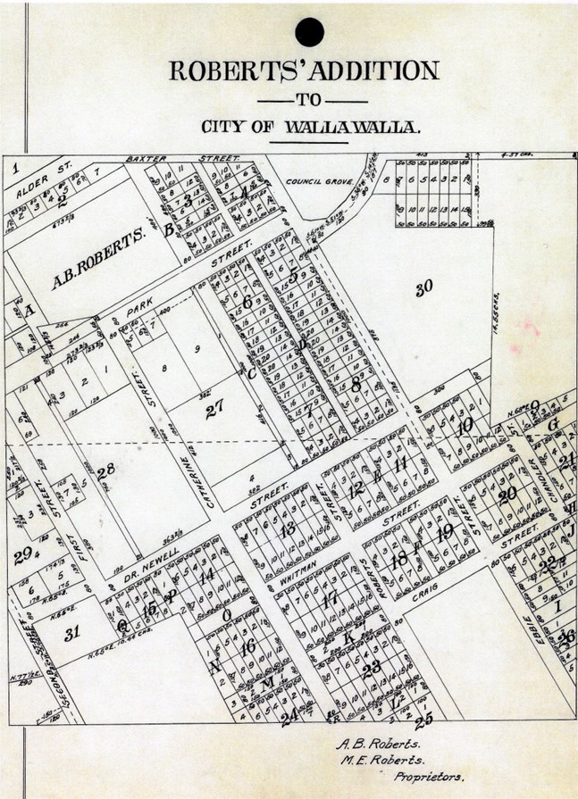 Eventually A. B. and Martha Roberts extended their holdings, including acreage granted by the United States Government under the Homestead Act that ranged from approximately First Street on the west to approximately Howard Street on the east, and from approximately L Street on the south to Alder Street to the north. Platted in 1870, the land was recorded January 20, 1871 as Roberts’ Addition to the City of Walla Walla.
1/1/1874, Sheriff’s Deed, B. W. Griffin, Sheriff of Walla Walla County, W.T. to John Bryant, as the result of court action of 10/3/1872 in favor of John Bryant against A. B. Roberts following which on 11/18/1872 at auction, including fractions of Blocks H and J; Lots 1, 2, 3 and 4 of Block I; Lots 1 and 2 of Block K (illeg.) 80 by 200 feet each; Lots 1, 2, 3 and 4 of Block N; Block C 80 by 1,000 feet; and Lot 1 in Block 27, $280.70 in gold coin.
7/25/1877, Sheriff’s Deed, Burrell W. Griffin, Sheriff of Walla Walla County, W.T. to Thomas Ronan, Blocks 14, 22 and 26 of Roberts’ Addition to the City of Walla Walla, plus land is Sections 22 and 27, that is the result of court action against Alvin and Martha Roberts for failure to comply with a prior court order assessing them $2,720 in gold coin, with interest of 2% per month commencing 9/1/1873, $1,085 in gold coin.
10/22/1877, Warranty Deed, Thomas Ronan, grantor; George D. Goodwin, grantee, Block 22 of Roberts’ Addition, $285 in gold coin.
9/3/1881, Warranty Deed, George D. and Demelda Ann Goodwin, grantors; John A. Paddock, Bishop of Washington Territory, grantee, Blocks 22 and 26, Roberts’ Addition, $1. Bishop Paddock (1825-1894) was the first Episcopal Bishop in Washington Territory.
6/3/1882, Warranty Deed, George D. and Demelda A. Goodwin, grantors; Philena McKee, grantee, Lots 1, 2, 3 and 12, Block 22, $250.
5/28/1889, Warranty Deed, Alexander W. and Philena McKee, grantors; G. W. Somerndyke, Jr. and C. B. Livermore, grantees, Lots 1, 2, 3 and 12, Block 22, $800.
3/31/1890, Warranty Deed, C. B. and Nellie A. Livermore; G. W., Jr. and Emma R. Somerndyke, grantors; Joseph H. Dixon, grantee, Lot 1, Block 22, $350. This is the first transaction that deals exclusively with Lot 1, i.e., 428 Craig Street..
7/28/1893, Warranty Deed, Joseph H. and Sarah E. Dixon, grantors; James S. Dixon, grantee, Lot 1, Block 22, $250.
4/4/1899, Indenture, The City of Walla Walla, grantor; Adolph Schaefer, grantee, beginning at the intersection of the Southerly line of Craig Street with the West line of Howard Street and running thence South 0° 10’ West 60 15/100 feet; thence South 29° 50’ East 103 15/100 feet to the West line of Howard Street; thence North 0° 16’ East 120 feet to the place of beginning, being a part of Block “J” of Roberts’ Addition, said grantee to pay the tax for grading said Howard Street, and for sidewalks along said premises, $1. Adolph Schaefer was employed as a watchmaker at Ludwigs & Hunzicker Jewelers. He and four other Schaefers were listed in the 1900-01 city directory as residing at 404 Craig Street.
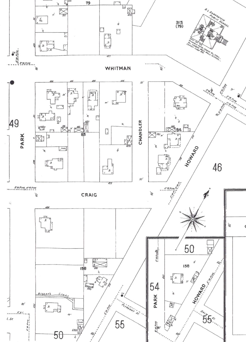
The original 1905 edition of the Sanborn Fire Insurance Map shows Lots 1, 2 and “J” of Block 22 vacant
5/8/1901, Warranty Deed, Adolph Schaefer, a bachelor, grantor; Mattie L. Schumacher, grantee, Lot 1, Block 22, also “beginning at the intersection of the Southerly line of Craig Street, with the West line of Howard Street, and running thence South 60° 10’ West 60.15/100 feet; thence South 29° 50’ East 103.85/100 feet to the West line of Howard Street; thence North 0° 15’ East 120 feet to the place of beginning, being a part of Block “J” of Roberts’ Addition,” $300. This deed appears to define the current property.
6/22/1901, Warranty Deed, Mattie L. and Walter C. Schumacher, grantors; V. H. Rogers, grantee, Lots 1, 2, 3 and 12, Block 22 and that portion of Block J as described in the above warranty deed, $2,000.
8/15/1901, Warranty Deed, V. H. and Elizabeth Rogers, grantors; Lillian G. McCoy, grantee, same as above, $2,600.
7/1/1903, Warranty Deed, Lillian G. and Fred McCoy, grantors; C. T. and Nannie E. Cation, grantees, $1.
5/1/1905, Warranty Deed, O. T. and Ella Cornwell; A. M. and Nannie E. Cation, grantors; Erastus W. Oliver, grantee, commencing at the Northwesterly corner of Lot 1 in Block 22… thence Southerly along the Westerly line of said lot 120 feet; thence Easterly at right angles to intersect Howard Street; thence North 0° 16’ East along the Westerly line of Howard Street to the Northeasterly corner of Lot “J” of said block; thence South 60° 10’ West along the Southerly line of Craig Street 110 and 15/100 feet, more or less, to beginning. Said property embracing all of Lot “J” and part of Lot 1 in Block 22, $900. Oliver Cornwell was president of Walla Walla Lumber Company. Erastus W. Oliver was a farmer with residence in College Place in the 1905 city directory. The 1906 city directory listed his address as 428 Craig Street.
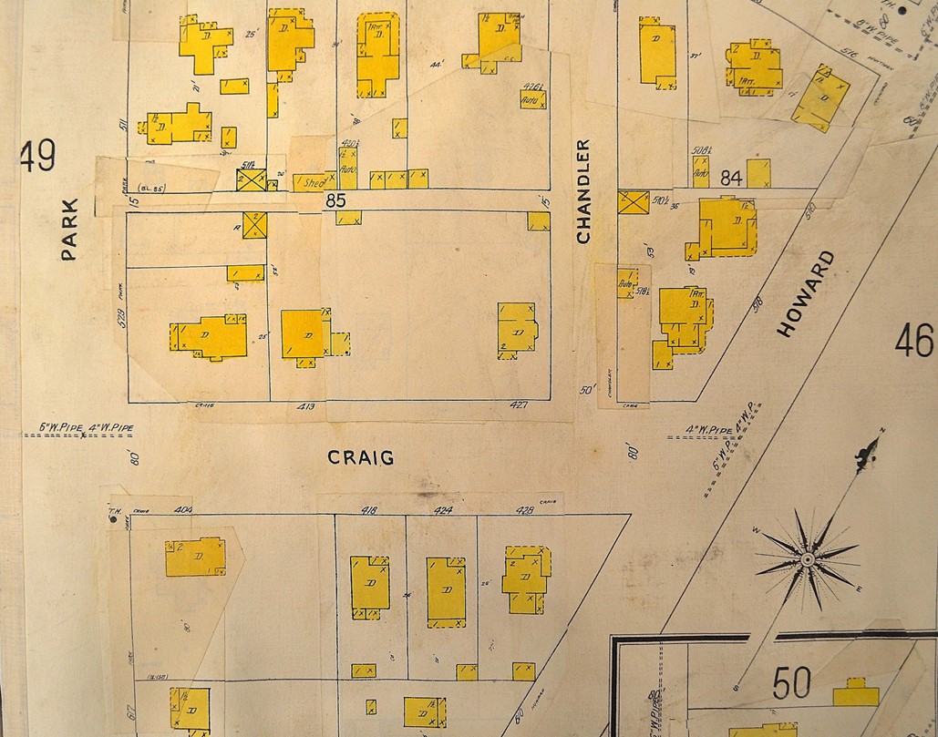
The July 1909 update to the 1905 map clearly shows the house at 428 Craig Street on Lot 1.
7/27/1905, Quit Claim Deed, J. K. and Amy F. Wilson, grantors; O. T. Cornwell and A. M. Cation, grantees, all of Lot “J”, Block 22 of Roberts’ Addition excepting a portion of the Northeast corner of Craig and Howard Streets sufficient to make it round instead of pointed, for sidewalk purposes, $1.
10/2/1935, Executrix’s Deed, Olive Haynes for the estate of Rebecca Oliver, deceased, grantor; F. B. Clark, grantee, commencing at the Northwest corner of Lot 1, Block 22, Southeasterly along the Westerly line 120 feet; thence Northeasterly parallel to the South line of Craig Street to the Westerly line of Howard Street to the Northeasterly corner of Block “J”; thence Southwesterly along the Southerly line of Craig Street to the place of beginning, $1,140.
6/4/1937, Warranty Deed, F. B. and Lillian C. Clark, grantors; Floyd and May Dorothy Ward, grantees, same as above executrix deed, $10.
2/10/1938, Warranty Deed, Floyd and May Dorothy Ward, grantors; F. B. and Lillian C. Clark, grantees, beginning at the Northwest corner of Lot 1, Block 22, running thence Southeasterly along the Westerly line of Lot 1 120 feet; thence Northeasterly parallel to the South line of Craig Street to the Westerly line of Howard Street; thence North 00° 16 feet East along the West line of Howard Street with the Southerly line of Craig Street; thence South 60° 10 feet West along the Southerly line of Craig Street 110.15 feet to the point of beginning, $10.
3/31/1938, Quit Claim Deed, Lillian C. Clark, grantor; F. B. Clark, grantee, remiss, release, convey and forever quit claim, same as described in above warranty deed, $10.
4/18/1938, Warranty Deed, F. B. Clark, grantor; C. Glen and Manza Thomas; Belle Thomas, a widow, grantees, same as described above, $10.
3/21/1944, Warranty Deed, Manza Thomas, a widow and Belle M. Thomas, a widow, grantors; John P. and Gertrude E. Penfield, grantees, same as warranty deed of 2/10/1938, $2,625.
3/26/1956, Warranty Deed, John P. and Gertrude E. Penfield; grantors; Darell V. and Beverly D. Jones, grantees, the Northerly 120 feet of Lot 1, Block 22.
2/15/1962, Statutory Warranty Deed, Beverly D. Southerland, formerly Jones, grantor; J. D. and Roberta L. Mayer, grantees, beginning at the Northwest corner of Lot 1 in Block 22 and running thence Southeasterly along the Westerly line of said Lot 1 a distance of 120 feet; thence Northeasterly parallel to the Southerly line of Craig Street to the West line of Howard Street, as said Howard Street is now used and established; thence North 00° 16’ East, along said West line of Howard Street to the point of intersection of said West line of Howard Street with the Southerly line of Craig Street; thence South 60° 10’ West, along said Southerly line of Craig Street a distance of 110.15 feet to the point of beginning, subject to easements and rights of way of record, same as warranty deed of 2/10/1938, $10.
9/20/1971, Quit Claim Deed, Jerome F. and Genna K. Heinzman, grantors; J. D. and Roberta L. Mayer, grantees, $600.
3/9/1982, Quit Claim Deed, J. D. and Roberta L. Mayer, grantors; Irving Mayer, grantee, for love and affection.
6/23/1982, Quit Claim Deed, Irving Mayer, grantor; J. D. and R. L. Mayer, grantees, for love and affection.
6/29/1982, Statutory Warranty Deed, J. D. and R. L. Mayer, grantors; David L. and Shirley Smith, grantees, $10.
5/2/1984, Statutory Warranty Deed, David L. and Shirley M. Smith, grantors; Sandy Farrens, a single person, grantee, for consideration of assumption of a mortgage dated 6/30/1982.
9/17/2021, Statutory Warranty Deed, Sandy L. Bell who acquired title as Sandy Farrens, as her separate property, grantor; Caitlen Alyssa Daniels and Charles Jeffrey Powell, grantees, the Northerly 120 feet of Lot 1, Block 22 and South 27 feet of the Northerly 120 feet of Lot 2, Block 22, $565,000.
5/17/23, Statutory Warranty Deed, Caitlyn Alyssa Daniels, grantor; Jed C. Salminen, grantee, Roberts’ Northerly 120’ of Lot 1, Block 22 Tri Out of South 27’ of Northerly 120’ of Lot 2, Block 22 and Roberts’ Block 35 (“J”) Tax Parcel nos. 36-07-29-87-2201 and 36-07-29-87-3500.
Construction of Building
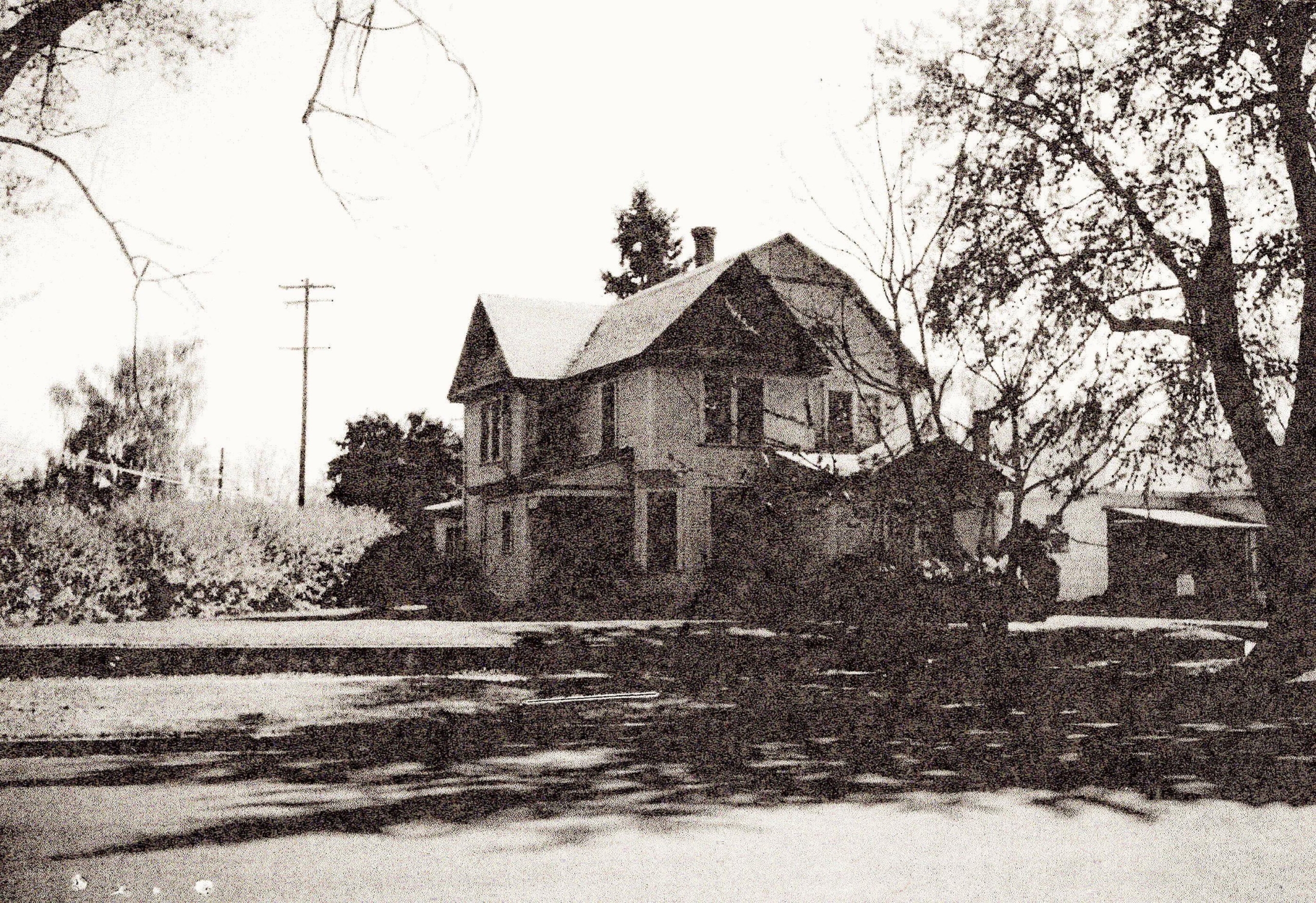
This undated photograph is from the Assessor’s archived hard copy file on 428 Craig Street. It is
difficult to determine what occupies the front of the projection on the right mentioned below,
but it may be a pair of double-hung windows somewhat larger than the two windows currently in place.
The Assessor’s records list the build date for 428 Craig Street as 1901; often these dates are estimated based on the appearance of the structure. Building permits for the City of Walla Walla are preserved at Whitman Archives only as far back as September 1907. A warranty deed was signed and filed on 5/1/1905 selling Lots 1 and “J” to Erastus W. Oliver for $900. The 1906 city directory listed Mr. Oliver’s address as 428 Craig Street. The original 1905 edition of the Sanborn Fire Insurance Map shows Lots 1, 2, and “J” of Block 22 vacant. The July 1909 update to the 1905 map clearly shows the house at 428 Craig Street on Lot 1. Thus, it can be concluded that the construction of the house was completed by 1906 and the building permit would not have been preserved.
Erastus Oliver was first listed in the city directory in 1905 as a farmer residing in College Place. While he was quite new to Walla Walla County, he had been a successful farmer for some time, as will be described, and like many successful farmers he and his wife had likely reached the point where they wanted a big house in the city. Nonetheless, it was difficult to find information on him. Whitman Archives has nothing. Online searches initially led to nothing. He is not buried in Mountain View Cemetery, as is his wife, which seems unusual.
Eventually continued searches online led to a 1903 history of North Idaho and that book contains a quite remarkable history of Erastus W. Oliver written in the parlance of the time. It is worth including here in part. Also located online was a lengthy history of Mr. Oliver published in Grangeville, Idaho in 1904; due to its length, it is attached to this report as an addendum.
Erastus W. Oliver is conceded to be one of the best all round businessmen in the northern part of the state, and the continued success that has been his for years in all lines of enterprise demonstrates this fact, while as a man of worth and integrity he stands high among all.
Erastus W. Oliver was born in Putnam county, Ohio, on February 2, 1841, the son of Richard and Jane (Harden) Oliver, natives of Ohio and born in 1805 and 1812, respectively. The father [was of] Scotch extraction. The mother [was also] of Scotch extraction. Our subject grew up in Ohio and all the schooling of his boyhood days could be summed up in one year. Upon arriving at manhood’s estate, he made a study of everything that came before him, and the result in that he is an exceptionally well informed and thoroughly practical man. His first job was carrying water on the Wabash railroad when he was twelve, and then commenced his independent career. From that day to this, while taking up anything and everything that came to his hand, Mr. Oliver has been successful, and is now handling stock and real estate in a brokerage business, does farming, raises stock, deals in hay and grain, and is interested in mining. When ninetheen [sic] he was contracting ties for the railroad in Ohio, later did the same business in Missouri and in 1871 came to Umatilla county, Oregon, and commenced farming and raising stock. He made a success of it, although he knew nothing of the business. In 1880 he went to Whitman county, Washington, where he farmed and dealt in stock on a large scale, and here he reaped a rich reward for his skill and industry. In 1892 he sold some of his property and came to Grangeville [Idaho], which he has made his home since.
In 1861 Mr. Oliver married Miss Rebecca, daughter of John and Magdalene (Nittle) Stalters. Mrs. Oliver was born in Ohio on January 5, 1842, and has three brothers, — George, John and Ezra. John was in Andersonville prison; and Ezra was also in the war. Mr. Oliver had eight brothers; but two are living, — Nicholas B. and Reuben J. Abraham H. was in the war and received a wound in the battle of Sandpoint. Alexander U. was also in the Civil war; both are deceased. Seven children have been born to Mr. and Mrs. Oliver, — Abraham N., in Whitman county; John F., Andrew J., Bert H., Abbie J. and Holsclow, all in Idaho county; Olive Haynes, in Pendleton. Mr. Oliver is a blue lodge Mason, and also belongs to the Eastern Star lodge. He is a stanch [sic] Republican and has been instrumental in electing numerous of his friends to office, but never would allow his name to be put up for nomination. He is frequently in the state convention, and the last year helped to nominate Governor Morrison and Supreme Judge Alchie. Mr. Oliver is one of the heavy taxpayers of the county and is a man of reliability and excellent standing.
It has not been possible to determine when Erastus Oliver died. He was listed in the 1907 Walla Walla city directory, but in 1908 the only listing for 428 Craig Street was for Mrs. Rebecca Oliver. Yet in the 1909-10 edition Erastus Oliver was again listed. Through the 1921-22 edition city directories usually listed only Mrs. Oliver, but on occasion listed Erastus W. Oliver. The above bio mentions that he was a Mason. It was mentioned that he is not buried in Mountain View Cemetery, but Rebecca Oliver is buried there in the Masonic section. She died June 23, 1923. Her estate was not settled until 10/2/1935 when 428 Craig Street was sold by her daughter, Olive Haynes, who resided with her husband next door at 424 Craig Street.
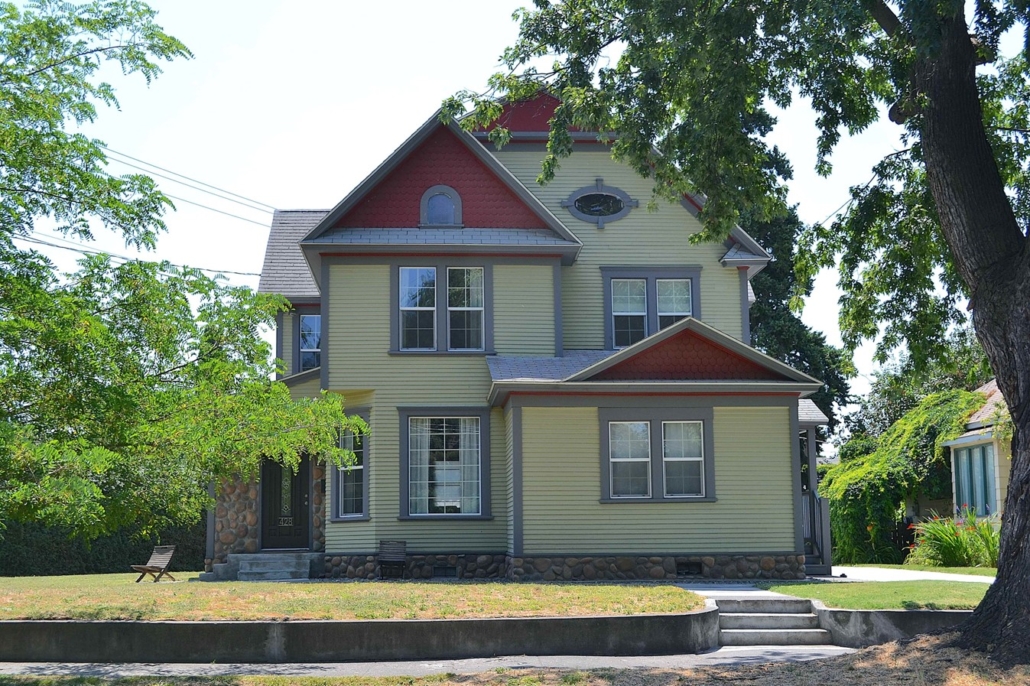
428 Craig Street is somewhat difficult to categorize from an architectural perspective, but it is most accurately described as late Queen Anne though largely unadorned, lacking decorative touches such as turned spindles around porches, fretwork at the gables, etc. It may have had some ornamental features when built that have subsequently been removed. It is a large, two and one-half story house with an elaborately cross-gabled roof. The most eye-catching bit of frolic remaining is the sprightly oval window at the attic level of the main gable. The projection at the right front of the house is a puzzle. It is pedimented, but the projection itself extends well beyond the east end of the pediment, giving an unbalanced look, and the pair of windows is not centered under the pediment. Perhaps this was a large porch originally and extended when it was enclosed. Exterior updates to the house appear to have been done in recent years. Building permits at Whitman Archives terminate at 1953, and City of Walla Walla Planning and Development only has one permit on file for a new roof in 2006. Replacement of wood sash windows with vinyl, the application of stonework to the foundation and recent concrete steps are not documented. The house is beautifully maintained and is a contributing presence to Craig Street’s historic homes.
References
- TitleOne (formerly Pioneer Title)
- Whitman Archives
- Sanborn Fire Maps, 1905 original and 1905 with 1909 updates
- City of Walla Walla Directories, various years
- Walla Walla County Assessor
- Cindy Fazio, Cadastral GIS Technician, Walla Walla County Assessor’s Office
- An Illustrated History of North Idaho, Embracing Nez Perces; Idaho, Latah, Kootenai and Shoshone Counties, State of Idaho, Western Historical Publishing Company, 1903
- The Standard: Industrial Edition, Lisle & Bradley, Grangeville, Idaho, December 1904
- Standard Atlas of Walla Walla County Washington, George A. Ogle & Co., Publishers and Engravers, Chicago, 1909


