History of 312 South Division Street, Walla Walla, WA
Legal Description
Reed’s Addition, Tax Lot 4, Block 9
Full Legal Description
Beginning at a point in the East line of Block 9 of Reed’s Addition to the City of Walla Walla, according to the official plat thereof recorded in Volume A of plats at page 55, records of Walla Walla County, which point is 67 feet North, measured along the East line of said Block 9, from the Southeast corner thereof, and running thence West, parallel to the South line of said Block 9, a distance of 126 feet; thence North, parallel to the East line of said Block 9, a distance of 65 feet; thence East, parallel to the South line of said Block 9, a distance of 126 feet to the East line of said Block 9; thence South along said East line a distance of 65 feet to the point of beginning.
Title and Occupant History
Washington Territory was created in 1853. In 1854, the new territorial legislature created Walla Walla County, which stretched from the crest of the Cascade Mountains to the crest of the Rocky Mountains in the present states of Washington, Idaho and Montana. In 1855, Isaac Stevens, governor of Washington Territory, held a council on the banks of Mill Creek at the present site of Walla Walla with representatives of regional Indian tribes to purchase land from them. The Yakamas, Cayuses and Walla Wallas were dissatisfied with the treaties and the intrusion by whites into their lands before the treaties’ ratification, and war followed. Missionaries, former French-Canadian employees of the Hudson Bay Company trading post at Wallula, and soldiers at the military Fort Walla Walla were the primary European occupants of the area prior to 1859, when the treaties were finally ratified and the land was opened for settlement. The transfer of ownership occurred by virtue of a treaty signed on June 9, 1855 in Walla Walla and ratified on March 8, 1859 by President James Buchanan, in which all of the land in the Walla Walla area was acquired from the Cayuse and Walla Walla Indian tribes.
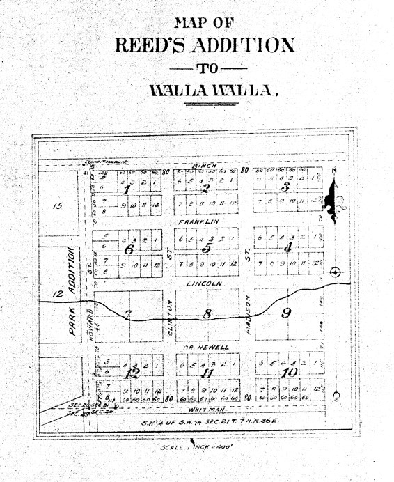
The 1878 plat map of Reed’s Addition.
The town of Walla Walla was originally laid out by County Surveyor Hamet Hubbard Case in 1859, prior to its formal incorporation as a city in 1862, as a one-quarter mile square with its eastern side centered on the point where Main Street crossed Mill Creek (at roughly the point where it does now). The original plat was lost, probably in the fire of 1865. Thus, the earliest plat on file is one made by W. W. Johnson, City Surveyor, in July 1865 that claims to have made corrections to Case’s survey. Johnson’s survey was made the official plat of the City of Walla Walla on September 25, 1866, filed and recorded July 5, 1867. The City of Walla Walla received a Trustee Town site from the U. S. Government that consisted of 80 acres, issued on July 20, 1869 by the Vancouver, W. T. District Land Office.
Isaac N. and Cynthia J. Reed had the land that constitutes Reed’s Addition to the City of Walla Walla surveyed in 1878. The survey was filed on November 1, 1878 and recorded the following day in Volume A of Plats on Page 55. Franklin Street on the plat map (see below) has been renamed Washington Street and Birch Street, which no longer extends east beyond Park Street, is now East Alder Street.
The plat map notes that the survey was completed in October 1878, but the surveyor’s name is not recorded. No record of the Reeds residing in the city of Walla Walla or Walla Walla County could be located in a perusal of numerous city directories although they had a definite connection to the city; Reed’s wife Cynthia was a daughter of H. H. Hungate. The only documentation for Isaac Reed’s residing here was in The Statues of California 1875-76, published in San Francisco in 1876, in which he was listed as Commissioner of Deeds for Washington Territory, to which he had been appointed on 11/25/1872, with residence listed as Walla Walla.
Census records and Cook County, Illinois death records note that Isaac N. Reed was born in Delaware County, Ohio in 1837. He married Cynthia Jane Hungate (b. 1842 in Illinois) in 1863. The Reeds had two boys, Calvin (b. 1865) and Howard (b. 1878).
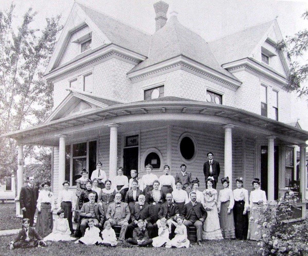
The second Hungate house extant at 429 East Sumach Street, showing Cynthia Jane Hungate Reed in the second row, fifth from left.
Isaac Reed was listed variously as a traveling book agent and a publisher. Travel he did, with residences in Laramie, WY, St. Louis, MO and Los Angeles, CA. He died in 1905, at which time he was residing at 1429 Michigan Avenue in Chicago. His wife Cynthia, who was living in Dayton by 1911, outlived him, dying in California in 1930, aged 87.
The two lots on which the large masonry house at 403 East Rose Street, a block south of the above Hungate house and built for Dr. James Cropp, were purchased from Isaac and Cynthia Reed.
The transactions below between 12/30/1861 and 1/20/1872 concerning the property that includes but is not limited to what is currently 312 South Division Street were located using the Reverse Directory to Deeds covering the early years through 12/31/1901, located in the County Auditor’s Vault. The patent of 8/3/1866 is included on the U. S. Department of the Interior Bureau of Land Management’s website.
12/30/1861, Deed, John McComb, grantor; W. H. Patten, grantee, 160 acres in Section 21, Township 7-North, Range 36-East, plus additional land in Section 20, $2,000. McComb was the first patent holder for the land (see 8/3/1866 below). William H. and Elizabeth Patten held vast amounts of property in Walla Walla.
3/9/1862, Military Bounty Land Act of March 3, 1855; “Military Land Warrant of (date illeg.) in the name of Mary E. Johnson…has been located by John McComb for the Western half of land in Section 21, Township 7-North, Range 36-East plus (illeg.) of Section 21, Township 7-North, Range 36-East plus land in Section 20…subject to any pre-emption claim which may be filed for said land within forty days from this date.”
4/12/1862, Deed filed 8/11/1866, W. H. and Elizabeth Patten, grantors; Samuel Phinney, grantee, 40 acres in the Southwest quarter of the Southwest quarter of 21-7-36, $900.
2/22/1865, Deed, Samuel Phinney, grantor; A. H Robie, grantee, 60 acres in 21-7-36 plus 106 acres in 36-7-36 plus 60 acres in 28-7-36, $2,000. Phinney arrived in Walla Walla in 1857, moving on to Idaho where he joined in the gold rush before returning to Walla Walla. He purchased 160 acres from the United States Government in April 1, 1865. Albert Hugh Robie was a Special Indian Agent and, like Phinney, he resided both in Walla Walla and Lapwai, ID. He was an interpreter for Isaac Stevens during the 1855 treaty councils and was married to Pah Tis Sah, daughter of Chief James of the Nez Perce.
7/25/1865, Deed, A. H. and Martha Robie, grantors; C. S. Bush, grantee, the South one-half of the Southeast quarter and the South one-half of the Southwest quarter of [21-7-36] plus additional property in Section 28, $5,000. Charles S. and Nancy J. Bush owned property on both sides of Main Street that currently is situated along the 100 block of East Main, as well as land that became City Park (renamed Pioneer Park).
8/3/1866, Patent, Mary E. and William Johnson and John McComb, a Serial Patent issued in the Vancouver, W.T. Land Office by the authority of the Scripps Warrant Act of 1855 for 160 acres, Document 76118. This acreage included two parcels in Section 21 and one in Section 20.
1/20/1872, Deed, Charles S. and Nancy F. Bush, grantors; Isaac N. Reed, grantee, the Southwest quarter of the Southwest quarter of Section 21, Township 7-North, Range 36-East, 40 acres, $3,000.
The remaining legal documents regarding the property that includes 312 South Division were located at TitleOne Title & Escrow, formerly Pioneer Title.
8/10/1876, Right of Way Deed, Isaac N. and Cynthia J. Reed, grantors, Sewall Truax, grantee, to lay, keep and maintain three and one-half inch water pipe across the Southwest Quarter of the Southwest Quarter of 21-7N-36E, $1. Maj. Sewall Truax was in charge of laying the first eight miles of rail for the Walla Walla & Columbia River Rail Road Company, and was also responsible for laying out the city of Dayton, Columbia County.
5/2/1884, Right of Way Deed, Sewall and Sarah E. Truax, grantors; City Water Company of Walla Walla, a corporation, grantee, all water rights granted in the deed of 8/10/1876, $100.
5/23/1890, Agreement for Deed, Isaac N. and Cynthia J. Reed, grantors; W. B. Coyle, grantee, various parcels in Block 9 of Reed’s Addition including, but not limited to, Lot 4, $800.
7/15/1891, Quit Claim Deed, Willard B. Coyle, a single man, grantor; Mrs. Sarah A. Coyle, grantee, considerable property in Block 9 including, but not limited to, Lot 4, $500.
7/15/1891, Warranty Deed, Isaac N. and Cynthia J. Reed, by John F. Boyer, their attorney, grantors; Sarah A. Coyle, grantee, property as in above Quit Claim Deed, $800.
19/21/1891, Warranty Deed, Sarah H. and W. F. Coyle, grantors; Frank M. Shelton, grantee, property as in above Warranty Deed, “subject to a mortgage made by the grantors to The National Building Loan & Trust Association of Walla Walla of $800,” $1,900.
10/31/1891, Warranty Deed, I. N. Reed by Cynthia J. Reed, grantor; Frank M. Shelton, grantee, “commencing 240 feet East from the Northwest corner of Block 9…thence East along the South line of Lincoln Street 60 feet, thence at right angles South 288 feet to the North line of Dr. Newell Street, thence West along said North line of Dr. Newell Street 60 feet, thence at right angles North 288 feet to the place of beginning,” $600
5/16/1903, Warranty Deed, Frank M. Shelton, unmarried, grantor; August Lonneker, grantee, “the Easterly one-half of Block 9 in I. N. Reed’s Addition,” $3,700. Lonneker was a teamster with residence at 835 Newell Street as listed in the 1904-05 City Directory.
3/15/1909, Indenture, August and Sophie Lonneker, grantors; T. J. Ennis, grantee, property as in above Warranty Deed of 1903, $9,000. Ennis was president of Drumheller & Ennis at 13 West Main Street, dealers in real estate, insurance and loans, with residence in 1909 at 226 Newell Street.
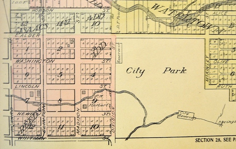
Reed’s Addition as shown in the 1909 Atlas of Walla Walla County showing Block 9 ubdivided into building lots.
10/21/1909, Warranty Deed, T. J. Ennis et ux, grantor; Mary E. Woodruff, grantee, “…beginning at the Northeast corner of Block 9…156 feet South of the Northeast corner, thence West 126 feet, thence South 65 feet, thence East 126 feet, thence North 65 feet to the Place of Beginning,” $1,677.50. This appears to be the first separation of what is currently Lot 4 as a separate sale. As can be seen on the 1878 plat map of Reed’s Addition, of the ten blocks comprising the addition only Blocks 7, 8 and 9 were not platted into individual building lots. Possibly this was because Robert’s Creek (now Lincoln Creek) crosses all three blocks. It is not known just when those three blocks were divided, but Block 9 was divided into building lots prior to 1909; the Standard Atlas of Walla Walla County printed in Chicago in 1909 shows Block 9 divided into building lots. Charles E. Woodruff was a lumberman. His wife, Mary, and their three children, Rhea, Rolland and Ruth were all residing by 1910 at 312 South Division Street.
5/12/1920, Warranty Deed, Mary E. Woodruff, in and of her own right, grantor; Ben Colvin, grantee, Lot 4, Block 9, $10 and other valuable considerations. Colvin could not be located in city directories.
5/12/1920, Executrix Deed, Mary E. Woodruff, acting Executrix of the Estate of Charles E. Woodruff, deceased, grantor; Ben Colvin, grantor, Lot 4, Block 9, $7,500.
5/12/1920, Quit Claim Deed, Rolland C. Woodruff, Ralph E. Woodruff, Rhea M. Hudson, Ruth M. Woodruff, Charles E. Woodruff and Mary E. Woodruff, grantors; Ben Colvin, grantee, Lot 4, Block 9, $1.

An undated map of the Southwest Quarter of the Southwest Quarter of 21-7-North- 36-East. Block 9 is second from the bottom on the right.
11/27/1920, Statutory Warranty Deed, Ben Colvin, in and of his own right, grantor; Sherman Pettyjohn, grantee, Lot 4, Block 9, $8,000. Sherman Pettyjohn was a farmer who resided at 312 South Division Street.
5/25/1949, Deed (Life Estate in Rents), Mabel M. Pettyjohn, a widow, grantor; Hester S. Holaday and Margaret H. Pettyjohn, grantees, Lot 4, Block 9 plus eight other properties for “love and affection which she has and bears unto her daughters.” Both women resided at 312 South Division; Miss Pettyjohn was president of the Walla Walla County Pioneer Historical Society.
12/8/1978, Statutory Warranty Deed, Old National Bank of Washington, as Executor of M. H. Pettyjohn Estate, grantor; Kim D. and Janice M. Trusty, Lot 4, Block 9, $38,500. K. David Trusty was a teacher in Educational District 123 for juvenile offenders.
3/19/1987, Statutory Warranty Deed, Kim D. and Janice M. Trusty, grantors; Terrance Lee Sherrod, a single person, grantee, Lot 4, Block 9, $49,000. Following this sale, 312 South Division appears to have remained vacant for several years according to reverse city directories. Mr. Sherrod’s first city directory listing was in 1997.
11/25/1996, Notice of Trustee’s Sale at 315 West Main Street on 2/28/1997, Terrance and Jane Doe Sherrod for $5,325.28 arrears.
3/25/1997, Trustee’s Deed, Washington Administrative Services, Inc., grantor; Kelly Peterson, grantee, Lot 4, Block 9, $45,700 plus interest owed, $79,000 total. Kelly Peterson was owner of Kelly Peterson Farms. He resided at 606 Craig Street, and 312 South Division remained vacant.
6/27/1997, Statutory Warranty Deed, Kelly and Nikita Peterson, grantor; Shad and Emily Gadden, grantees, Lot 4, Block 9, $106,000. The Gaddens were not listed in the 1998 city directory and 312 South Division remained vacant.
9/16/2020, Death Certificate, Shad and Emily Gadden.
11/17/2020, Statutory Warranty Deed, Emily Gadden, grantor; Kenneth Alan and Caroline Marie Cogen, grantees.
Construction of Building
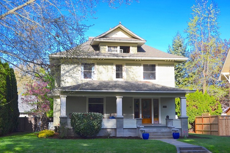
The Assessor’s Office property search page lists the build date for 312 South Palouse Street as 1916, while a 1979 tax document following the death of Miss Pettyjohn notes the house was constructed in 1912. The first edition of the 1905 Sanborn Fire Insurance Map depicts what appears to be a hipped roof, four-square house on the west side of South Division between Lincoln and Newell Streets, but it is drawn close to Lincoln Street where 310 South Palouse is located; 312 is situated closer to Newell Street.
On October 21, 1909, Mary E. Woodruff, purchased Lot 4 – the first separation of this lot from the rest of Block 9 – and was granted Building Permit 645 for which she paid a fee of $1.50 to construct a dwelling on “Division near Newell” estimated to cost $4,500. Construction doubtless commenced that year, although the house was probably completed and occupied early in 1910. The contractor was listed as Perry O. Colvin, a carpenter living at 403 North 3rd. (The address no longer exists, but it is likely one of a grouping of ornamental Victorian houses extant on North 3rd; 401 and 405 remain valid addresses.) As a lumberman, Mary Woodruff’s husband doubtless furnished much of the material for construction of the house.
312 South Division Street is a large, classic foursquare, sometimes referred to as ornamented or decorated box style. It is a two and one-half story house, with an asymmetrical street level façade facing Division Street, the entrance located on the far right. The second floor street façade and the attic portion are symmetrical; the latter features a projecting gable with a pair of small multi-pained windows. A full-width front porch adds weight to an already substantial appearing house. Siding is clapboard, ornamental shingles decorating the gable projection at the third level. This is a very pleasant and well cared for classic house.
Resources
- TitleOne Title & Escrow Company (formerly Pioneer Title)
- Whitman Archives (online, special thanks to Dana Bronson, Associate Archivist)
- Owens, George, 1865 Directory, W. W. Johnson, surveyor, A General Directory and
- Business Guide of the Principal Towns of the Cascade Mountains, San Francisco, 1865
- Walla Walla City Directories, various years
- Gilbert, F. T. Historic Sketches, Walla Walla, Whitman, Columbia and Garfield Counties, W. T. and Umatilla County, Oregon, Chicago, 1882
- Lyman, Prof. William Dennison, Lyman’s History of Old Walla Walla County, Vol. II, The S. J. Clarke Publishing Company, 1918
- Walla Walla County Auditor’s Vault, various Direct and Reverse Indexes to Books of Deeds
- Cindy Fazio, Cadastral GIS Technician, Walla Walla County Assessor’s Office
- Standard Atlas of Walla Walla County Washington Including a Plat Book of the Villages Cities and Townships of the County, George A. Ogle & Co., Chicago, 1909
- Walla Walla 2020 report on 310 South Division, Street, 1/1/2001
- Walla Walla 2020 report on 821 Lincoln Street, June 2018


