
History of 1116 East Isaacs Avenue, Walla Walla, WA

Legal Description
Lot 5 in Block 1 of the Amended Plat of Isaacs’ Third Addition to the City of Walla Walla, Washington, according to the official plat thereof of record in the office of the Auditor of Walla Walla County, Washington. Excepting therefrom, however, such part of said lot as has been dedicated to public use as a part of Isaacs Avenue, being a strip approximately 14.5 feet in width off the North end of said lot.
Title and Occupant History
Washington Territory was created in 1853. In 1854, the new territorial legislature created Walla Walla County, which stretched from the crest of the Cascade Mountains to the crest of the Rocky Mountains in the present states of Washington, Idaho and Montana. In 1855, Isaac Stevens, governor of Washington Territory, held a council on the banks of Mill Creek at the present site of Walla Walla with representatives of regional Indian tribes to purchase land from them. The Yakamas, Cayuses and Walla Wallas were dissatisfied with the treaties and the intrusion by whites into their lands before the treaties’ ratification, and war followed. Missionaries, former French-Canadian employees of the Hudson Bay Company trading post at Wallula, and soldiers at the military Fort Walla Walla were the primary European occupants of the area prior to 1859, when the treaties were finally ratified and the land was opened for settlement. The transfer of ownership occurred by virtue of a treaty signed on June 9, 1855 in Walla Walla and ratified on March 8, 1859 by President James Buchanan, in which all of the land in the Walla Walla area was acquired from the Cayuse and Walla Walla Indian tribes.
The town of Walla Walla was originally laid out by County Surveyor Hamet Hubbard Case in 1859, prior to its formal incorporation as a city in 1862, as a one-quarter mile square with its eastern side centered on the point where Main Street crossed Mill Creek (at roughly the point where it does now). Case’s plan was filed and recorded July 5, 1867 in Book A of Plats, Page 1. The City of Walla Walla received a Trustee Town site from the U. S. Government that consisted of 80 acres, issued on July 20, 1869 by the Vancouver, W. T. District Land Office.
1116 East Isaacs is located in Isaacs Third Addition, so named for Henry P. Isaacs and Lucie Isaacs, who played an important role in the city, and for whom Isaacs Avenue is named. Isaacs was influential in the development of Walla Walla as a wheat growing area. W. D. Lyman, in his 1918 History of Old Walla Walla County, states that Isaacs “demonstrated to the farmers that wheat could be produced profitably on the hills and uplands which in those early days had been given over to stock-raising.” He built numerous flour mills throughout the Northwest. According to Lyman, Isaacs’s “knowledge of the manufacture and handling of flour became proverbial and he was recognized as an authority on all matters pertaining thereto.” He found markets for wheat in the Orient, especially China. The Isaacses and their son J. C. Isaacs also founded the Walla Walla Water Company, providing Walla Walla with a reservoir, ditches, conduits and the possibility of irrigation for crops. The right to utilize subterranean water pertaining to the properties affected is included in several deeds in the area, including 1116 East Isaacs.
H.P. Isaacs died in 1900 without a will. In 1903, the Isaacs heirs, his children, formed the H. P. Isaacs Company. The breaking up of the 80-acre piece resulted in the development of Isaacs Third Addition to the City of Walla Walla, the plat for which was filed 12/20/1899. An Amended Plat of Isaacs Third Addition was filed 5/2/1900.
The first recorded transaction involving land that includes the present address 1116 East Isaacs was a deed filed on 7/25/1863 in which John Haley sold 26 and 81/100th acres to William H. Patten and wife for $100. William and Elizabeth Patten owned several other parcels on University and Pearson Streets that later became part of Isaacs Third Addition, as well as land in Green’s Park Addition along Alvarado Terrace. In 1863, Patten was a Walla Walla County Commissioner.
9/22/1881, Lease, H. P. and Lucie Isaacs, to J. C. Isaacs, “…for subterranean waters to supply the City of Walla Walla… maintain ditches and reservoirs and buildings enclosing same…” including 80 acres, a 25-year lease beginning 9/21/1881, $10,000.
9/11/1886, Right-of-Way Deed, J. C. Isaacs to The Walla Walla Water Company, a Corporation, the “right to enter upon the land, take and conduct and carry away all water, excavate and maintain ditches, conduits, and erect and maintain reservoirs and buildings to enclose such…” $1 and other valuable considerations.
6/27/1894, Quit Claim Deed, Lucie Isaacs, grantor; Henry P. Isaacs, grantee, for the above-referenced 80 acres, $1.
5/12/1900, Ordinance, The City of Walla Walla to The Public, to vacate the lands in Isaacs 3rd Addiction as filed 12/2/1899 and substituting an amended plat.
9/21/1900, Quit Claim Deed, Mary F. Green, a widow, grantor; H. P. Isaacs, party of the second part, grantee, to remove a fence along the north side of the property being vacated for the Mill Creek County Road (now East Isaacs Avenue).
1/11/1904, Deed, Grace G. Isaacs, Charlotte M. Doheny (formerly Charlotte Isaacs), Edwin S. and John P. Isaacs, grantors; H. P. Isaacs Company, a Corporation, grantee, Lots 5, 6, 7 and 14, Block 1, Isaacs 3rd Addition according to the amended plat thereof…” $1.
5/9/1908, Warranty Deed, H. P. Isaacs Company, a Corporation, grantor; Anna M. Shepherd, grantee, Lot 5, Block 1, Isaacs 3rd Addition, $800. This transaction is the first in which Lot 5 was sold individually. Anna M. Shepherd’s name does not appear in a Walla Walla City Directory, but James Shepherd, presumably her husband, was listed in the 1909-10 City Directory (© 1909) as principal of Sharpstein School, residing at 1116 Isaacs Avenue.
5/13/1915, Indenture, Anna M. Crock (formerly Anna M. Shepherd) of Spokane, grantor; George D. Minnick, grantee, Lot 5, Block 1, $6,000. George Minnick was listed in the 1916-17 City Directory as a farmer, with residence at the Grand Hotel. He appears to not have lived at 1116 East Isaacs Avenue. City Directories did not include a street directory until 1931, when it could be determined that Frank C. and Susan Letterer resided at 1116 East Isaacs. They both, or in later years, Susan alone, continued living there until the property was sold in 1940 by Walter C. Minnick (see Quit Claim Deed of 5/13/1940). Working backward from 1931, a Clara Letterer was found in the 1929-30 City Directory as the resident at 1116 East Isaacs. Lacking a street directory for earlier years, occupants between 1915 and 1929 could not be determined.
5/13/1940, Quit Claim Deed, Walter C. Minnick as Executor of the Last Will & Testament of George D. Minnick, deceased, grantor; James Floyd Shepherd, whose wife is J. June Shepherd, grantees, “… the lot and buildings located at 1116 Isaacs Avenue… more particularly described as follows: Lot 5, Block 1 of the Amended Plat of Isaacs’ Third Addition…” $1. It could be speculated that James Shepherd was a son of Anna M. Shepherd/Crock. With J. Floyd Shepherd, he operated Shepherd Bros. Auto Service Station, Tires, Batteries, Gas and Oils, Tire Repairs.
9/29/1949, Warranty Deed, James Floyd and J. June Shepherd, grantors; Rueben O. and Jean M. Beck, grantees, $10 and other valuable considerations. Rueben Beck was a designer with Wylie Monument Works.
6/30/1958, Statutory Warranty Deed, Rueben O and Jean M. Beck, grantors; John D. and Cornelia Mae Nourse, grantees, Lot 5, Block 1 “…excepting a strip 14.5’ wide on the North side to be used for public access…” Mr. Nourse was a salesman with Electric Supply & Fixture.
3/25/1963, Statutory Warranty Deed, John D. and Cornelia Mae Nourse, grantors; Hibbert R. and Sandra K. Roberts, $10. Hibbert Roberts was a professor at Whitman College.
9/17/1968, Statutory Warranty Deed, Hibbert R. and Sandra K. Roberts, grantors; Kensey D. and Barbara A. Stewart, grantees, $10 and other valuable considerations. Kensey Stewart was also a professor at Whitman College.
12/31/2013, Warranty Deed, Barbara Weitemeir-Stewart, grantor; Paul R. Fasciano and Teri J. Parke-Fasciano, grantees, $112,500.
7/16/2019, Statutory Warranty Deed, Paul R. Fasciano and Teri J. Parke-Fasciano, grantors; Lewis A. and Julie M. Rogers, grantees.
Construction of Building
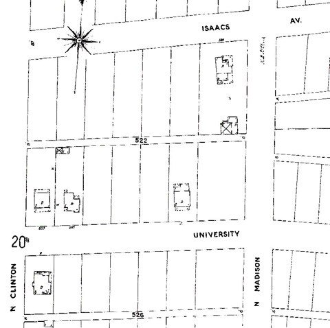
The 1905 Sanborn Fire Map shows the only house on Block 1 between Clinton and Madison Streets was on the corner of Isaacs and Madison.
The Walla Walla Assessor’s record for 1116 East Isaacs lists a build date of 1905. This date is an estimate, and from the above can be seen to be off a few years. The first edition of the 1905 Sanborn Fire Map shows only one building on the south side of Isaacs Avenue on Block 1, at the corner of Madison Street. On May 9, 1908, Lot 5 on Block 1 was sold separate from any other lots on that block to Anna M. Shepherd for $800. Seven years later, the former Mrs. Shepherd sold the lot on May 13, 1915 for $6,000. A price of $800 would indicate that the lot did not have any building on it; a sales price just seven years later of nearly eight times its 1915 sales price would indicate that by that time it contained a house. Indeed, a search of City of Walla Walla building permits revealed at on October 14, 1908 Building Permit 285 was issued to Anna M. Shepherd to construct a “2-story frame dwelling” on the lot, estimated to cost $2,500, for which she paid a fee of $1.50. Huntington & Bandy were listed as contractors. Bert M. Huntington was a major contractor in Walla Walla, and he employed William G. Bandy as a carpenter. In addition, the 1909-1910 directory, published in 1909, lists James Shepherd, presumably the husband of Anna, as living at 1116 Isaacs. While construction may have begun in 1908, it was not completed until 1909, which should be considered the build date.
The house itself features a gambrel roof that is unusual in that the major gambrel runs fore and aft, or centered, rather than side to side. Slightly smaller gambrel roof gables project from each of the sides of the main gambrel and are flush with the side walls. Siding is clapboard.
The appearance of the house is somewhat Colonial Revival or Adams style, although the gambrel roof was rarely used in this style of architecture and the fore and aft or centered main gambrel is even more rare. This could lead to speculation that the exterior was altered at some point decades ago. The modest ornamentation of both the offset entrance, drawn into rather than projected out from the house, with sidelights but no fanlight, and the large front window to the right of the entrance is Colonial. The flat panels of wood between the first and second floors, that normally would have continued the clapboard covering, might suggest that the eaves were shortened or otherwise altered at some point.
Resources
- Pioneer/Columbia Title
- Whitman Archives
- Sanborn Fire Map, 1905 1st addition before modifications
- Up-To-The-Times, September 1908 through December 1910
- Walla Walla County Auditor