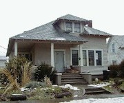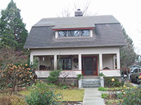
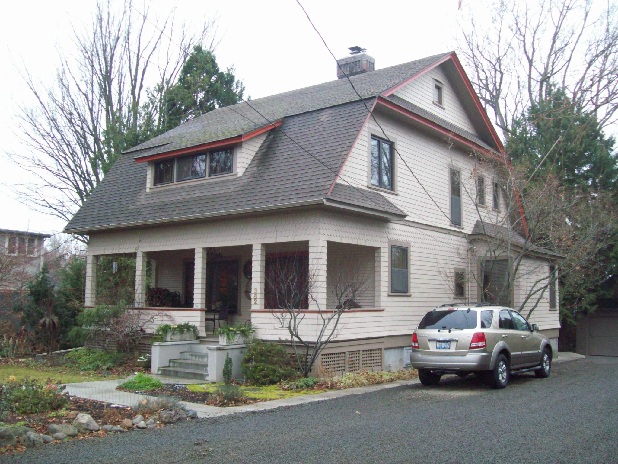
History of 382 Catherine Street, Walla Walla, WA
Legal Description (abbreviated):
Parcel A–50 feet by 140 feet on west side Catherine St. in Block 28 of Roberts Addition. begin 171 feet north of Newell St.
Parcel B–30 feet by 110 feet on west side Catherine St. adjacent to Parcel A on south side.
Title and Occupant History:
October 1, 1869-Alvin B. and Martha E. Roberts. husband and wife, sold 8 & 73/100ths acres to the south of Birch St. and west of Birch St., containing Parcels A & B, to John Sheets for $1000. (Deed Book F, Page 573; hereinafter F/573; see also H/525 entry of July 27, 1871 to correct errors in F/573)
A. B. Roberts came to Walla Walla in 1859 and was involved extensively in the nursery and real estate businesses.
John Sheets was also an early valley pioneer whose daughter married P. B. Johnson (see attached biographical information). John Sheet is listed in the city directory of 1880 as a capitalist with a residence on the west side of Catherine between Birch & Dr. Newell Sts.
January 20, 1871–A. B. and Martha Roberts platted Roberts Addition to the City of Walla Walla. (Plat Book A, Pages 21 & 22, County Auditor, Walla Walla County Courthouse)
January 27, 1877 –John and Margaret Sheets, husband and wife. sold the property described below to Parish B. Johnson for $1100: commence at intersection of Catherine and Dr. Newell Sts., run northerly along center of Catherine St. 211 feet, then at right angle westerly 180 feet, then at right angle southerly 211 feet to center Dr. Newell St., then at right angle easterly along center Dr. Newell St. 180 feet to the place of beginning. (S/457, see also 0/38 for same transaction)
September 5. 1894–Parish B. Johnson sold the property described below to Lydia Johnson, his wife, for $3000: begin at point on west line of Catherine St. 40 feet westerly of the center line of Catherine St. and 211 feet north of the intersection of Catherine and Dr. Newell Sts., thence west 140 feet, thence south 211 feet, thence east 140 feet. thence north 211 feet to the place of beginning. (57/478)
November 11, 1895–Lydia J. Johnson filed a Declaration of Homestead to the Public: “I am now and for many years have been, residing on said described premises [see below] using and occupying the same as and for a homestead, and that I intend to reside thereon and claim thereon as a homestead for our [Parish B. Johnson, her husband, and herself] benefit.” Begin at southeast corner of Block 28 of Roberts Addition, thence north on west line Catherine St. 171 feet, thence west 170 feet. thence south 171 feet, thence east 170 feet to the place of beginning. She also declare a cash value of $1950 for the homestead. (59/626)
September 16, 1879–a Real Estate Agreement was made wherein John Sheets agreed to sell the land described below to E. S. Kellogg for $1100: begin on center line Catherine St. at most northerly corner of piece of land owned by P. B. Johnson [north line of Parcel B], thence northerly 107 feet, thence westerly 180 feet, thence southerly 197 feet. thence easterly 180 feet to the place of beginning. (R/551; this transaction was finalized on February 14, 1880 with the deed issued to Delia A. Kellogg. S/605)
The 1880 city directory lists Dr. E. S. Kellogg as a homeopathic physician and surgeon with an office in the Paine Bros. block and a residence on Sumach between 2nd and 3rd Sts.
November 12, 1885–Archer S. Bowles, Sheriff or Walla Walla Co., Washington Terr., recorded the sale at public auction of the above described 107 foot by 180 foot parcel of land to John Lauga for $1290.25. The sale resulted from a District Court case: John Lauga, plaintiff v. E. S. Kellogg, Delia A. Kellogg, D. S. Baker, and John F. Boyer. defendants. (38/200)
John Lauga was not in the city directories for 1883-1889.
November 14, 1885–John Lauga granted B. L. Sharpstein the right to lay down and maintain a water drain or sewer pipe across the above described land for $20. (35/329)
B. L. 8harpstein is the famous Mexican War veteran, valley pioneer, lawyer, and judge who spent three terms in the territorial legislature, was active in local and state education matters, and was a member of the Constitutional Convention of Washington Territory, which prepared a constitution for statehood.
June 25, 1887 –John and Louise Lauga sold the 1071 x 1801 parcel to W. P Sturgis for $1200. (38/204)
March 14, 1889–W. P. and Susan Sturgis, husband and wife, sold the above property to Albert S. Riffle. (43/68)
The 1889 city directory lists Albert Riffle as a bridge engineer for the Oregon and Washington Territory Railroad and as boarding at 104 N. 3rd.
November 24, 1891–Albert S Riffle sold the above property to Isabella M. Riffle, his wife, for $1550. (48/498)
July 5, 1901–Isabella and Albert M. Riffle sold the property described below to Jennie C. Condit for $1000: begin at a point 171 feet northly from the intersection of Catherine and Newell Sts., run northerly 107 feet along Catherine St., thence westerly 140 feet, thence southerly 107 feet, thence easterly 140 feet to the point of beginning. (79/173)
The 1900-1901 directory lists Elbert M. Condit as pastor of the First Prebyterian Church with a residence at 419 Catherine; the 1902 directory lists Jennie C. Condit as the widow of Elbert M. Condit with a residence at 419 Catherine.
August 23, 1901–Jennie C. Condit, a widow, sold Parcel A (50′ x 140′) to Charles W. McKean for $600. (80/106)
The 1902 directory lists Charles W. McKean as a clerk for W. P. McKean, Clothing & Shoes, 129 W. Main, and boarding at 347 S. 4th. There is no 1903 directory. The 1904-1908 directories list Charles W. McKean with a home at 382 Catherine St.
Construction of the House: The directory evidence above points to a 1902 or 1903 date for construction of the house. The 1910 date listed by the Walla Walla County Assessor is clearly wrong.
April 6, 1904–Charles W. and Elizabeth F. McKean, husband and wife, sold Parcel A to A. R. Burford for $1 “and other valuable considerations.” (101/415)
The 1905-1908 directories list Alfred R. Burford as cashier of the First National Bank and secretary and treasurer of the Washington Printing & Book Manufacturing Co. with a home at 387 Catherine St.
April 10, 1908-A. R. and Ella L. Burford, husband and wife, sold Parcel A to Dale H. Preston. (111/23)
The 1909-10 directory list Dale H. Preston as a farmer with a home at 382 Catherine St. See biographical information attached.
October 15, 1908–Lydia J. Johnson. and unmarried woman,. sold Parcel B (30′ x 110′) to Stella A. Preston for $1500. (111/286)
The 1907 directory lists Lydia J. Johnson as the widow of Parish B. Johnson with a home at 392 Catherine St.
June 22, 1910–Dale H. Preston deeded his community right title and interest in Parcels A & B to Stella A. Preston, his wife, “Intending to divert said real estate from any or every claim or demand as community property and to vest the same in said grantee as her separate property.” (124/1)
Stella A. Preston is listed in the 1910-11 city directory as the widow of Dale H. Preston with a home at 382 Catherine St.
March 21, 1911–as part of the settlement of the estate of Stella Anderson Preston, deceased, Parcels A & B were sold by her brothers, J. P. and W F. Anderson, both of Portland, Oregon, and W. A. Anderson of Roseburg, Oregon, to their sister, Jennie Watts of Athena Oregon, for $1 “and other valuable considerations.” (126/172 and Superior Court Case 8507, Walla Walla Court Clerks Office, Walla Walla County Courthouse)
Jennie Watts is not listed in the 1911-12, 1915 or 1926-27 city directories.
December 7, 1929-Jennie and M. L. Watts, wife and husband, sold Parcels A & B to Mae W Chisholm for $1 “and ther good and valuable considerations.” (Deed #183201)
The 1930-1941 directories list Julius J. Chisholm as the president of J. J. Chisholm & Co., Inc., with a home at 382 Catherine St.
March 18, 1941–an Agreement was made between J. J. and Mae W. Chisholm, husband and wife, and C. W. and Mabel Gilbertson, husband and wife and owners of the adjacent property immediately north of Parcel A, to use in common a roadway along the line of the adjacent properties and to have “a mutual understanding that the future use of said roadway and easement will not ripen in to adverse use of either or any of said parties hereto.” (#273516)
April 10, 1944–J. J. and Mae W. Chisholm, husband and wife, and Ev~ I $. Thompson, widow and owner of lot to north or Parcel A, et. al., agreed to discontinue and terminate the use in common of the roadway in the above agreement. (#277052)
March 13, 1944-J. J. and Mae W. Chisholm sold Parcels A& B to C. Clifford
Minnick for $10 “and other valuable consideration.” (#277068)
C. Clifford Minnick is listed in the 1946-1976 directories as a farme with a home at 382 Catherine 8t.
December 2, 1960–C. Clifford Minnick, “for and in consideration of love and affection,” conveyed and quit claimed Parcels A & B to Blanche I. Minnick, his wife. (#425832)
March 3, 1978–in an Executor’s Deed, W. L. Minnick, executor of the will C. Clifford Minnick, deceased, transferred Parcels A & B to Grace ShepheH Kight, pursuant to the terms of the will. (#7802642)
The 1978 directory list Mel D. Kight, husband of Grace Kight, as the owner of Mel D. Kight Insurance Co. with a residence at 1851 Fairway Dr.
May 1, 1978-Grace Shepherd Kight, sold Parcels A & B “as her sole and separate property,” to Bruce A. Buchanan and Jeanie C. Garske, husband and wife, for $45,000. (#7803967)
March 28, 1991–Bruce A Buchanan, husband of grantee, conveyed and quit claimed all right, title and interest in Parcels A & B to Jeanie C. Garske to make it her separate property. (#9101976)
prepared by Michael W. Smith. 5/96