History of 115 North Sixth Avenue, Walla Walla, WA – Walla Walla Gas & Electric Plant
Property Description:
Parcel numbers: 36-07-20-77-2402, 36-07-19-63-0217
Amended Old Power Plant Parcel:
Commencing at the intersection of the North right of way line of West Rose Street with the West right of way line of Sixth Street in the City of Walla Walla, Washington;
thence North 31º23’06” West for a distance of 113.80 feet along said West right of way line of Sixth Street to the Southwest corner of Tract B shown on the survey filed in Volume 6 of Surveys at Page 131, being THE TRUE POINT OF BEGINNING;
thence South 58º40’34” West for a distance of 123.80 feet, along the South line of said Tract B to the Southwest corner thereof;
thence North 31º23’01” West for a distance of 64.32 feet, along the West line of said Tract B;
thence South 58º40’34” West for a distance of 31.69 feet along the South line of Tract A of said survey;
thence North 31º51’34” West for a distance of 36.40 feet;
thence North 58º18’54” East for a distance of 155.79 feet to point on the West right of way lie of Sixth Street;
thence South 31º23’06” East for a distance of 101.70 feet along the West line of Sixth Street to THE TRUE POINT OF BEGINNING.
TOGETHER WITH AND SUBJECT TO covenants, easements and restrictions of record.
Situated in the County of Walla Walla, State of Washington.
Title History:
Washington Territory was created in 1853. The new legislature created Walla Walla County in 1854 which stretched from the crest of the Cascade Mountains to the crest of the Rocky Mountains in the present states of Washington, Idaho and Montana. In 1855 an Indian council was held on the banks of Mill Creek at the present site of Walla Walla to purchase land from the Indians. The Yakimas, Cayuses and Walla Walla tribes were dissatisfied with the treaties and war followed. Missionaries, former French-Canadian employees of the Hudson Bay Company trading post at Wallula, and soldiers at the military Fort Walla Walla were the primary European occupants of the area prior to 1859 when it was opened for settlement. All of the land in this area was acquired from the Cayuse and Walla Walla Indian tribes by the U.S.. Government in a treaty signed on June 9, 1855, in Walla Walla, and ratified on March 8, 1859, by President James Buchanan.
Walla Walla was originally laid out by County Surveyor H. H. Case in 1859, before its formal incorporation as a city in 1862, as a one-quarter mile square with its eastern side centered on the point where Main Street crossed Mill Creek (at roughly the point where it does now). The City of Walla Walla received a Trustee Townsite from the U. S. Government which consisted of 80 acres issued on July 20, 1869, by the Vancouver, Washington Territory, District Land Office. Main Street originally followed the old Nez Perce Indian Trail. Consequently the streets leading off of it were at right angles to it, and were not in a north-south orientation. This was corrected as the city moved eastward which gave Walla Walla its peculiar street pattern with the three street intersection at Palouse, Boyer and Main Streets. To the original plat, additional parcels were annexed from time to time, usually bearing the name of the land owner of record at the time the additions were made.
The northwest corner of Sixth and Rose Streets is in the original plat (Section 20) for the City of Walla Walla, filed in Book A of Plats, Page 1, in 1867. The balance of the block, including this property, is in Section 19 immediately to the west of the original city boundary. The first owner of this property after the U. S. Government was Edmund H. Barron, who filed a patent, for conveyance of public lands, on this property in the Vancouver, Washington Territory, Land Office. This patent was not recorded until July 20, 1869. The first land recording on this property in the Walla Walla Land Office was on January 11, 1864, a Quit Claim Deed from the City and County of Walla Walla, Washington Territory, to Rachel E. Mann for $265 on Block E. John S. and Rachel Mann sold Lots 2 and 3 of Block E to Eliza McDough on January 18, 1865, for $700. On March 3, 1866, the City of Walla Walla, Washington Territory, signed a deed to Mrs. Eliza Ryan for fractional lots in Block E. on western line of City for $30. Mrs. Ryan sold all of Block E, except the water right which was owned by I. T. Reese, to C. M. Steinberger on February 17, 1868, for $750. On this same date, I. T. Reese sold a further portion of this property to C. M. Steinberger excepting the right of way to maintain a head race across said premise and conduct water from Mill Creek to Reese’s mill. Reese operated one of the first stores on “Main Street” (actually the Nez Perce trail) in 1859.
On May 30, 1873, a Decree in Chancery in District Court of the First Judicial District in Washington Territory was awarded to Julia L. Cock against C. M. and Sarah E. Steinberger. The property was sold at auction on October 4, 1873, for $260. On October 19, 1873, Sheriff B. W. Griffin issued a Sheriff’s Deed to Julia L. Cock for Lots 1-4, Block E. On April 12, 1873, Isham T. Reese declared bankruptcy. On December 4, 1874, Oliver P. Lacy, Assignee of Isham T. Reese, Bankrupt, gave an Assignee’s Deed to Andrew McCalley. Multiple deeds and quit claim deeds were filed after this with many attempts at a legal description, including “the mill lot line with its many meanderings marked in red ink” and the “southwest corner of the garden.” These deeds to clear McCalley’s title came from John F. and Sarah E. Boyer, William and Julia Cock, C. M. and Sarah E. Steinberger, B. L. and Sarah J. Sharpstein. On November 4, 1879, Andrew and Sallie V. McCalley sold 9 parcels including this one to John F. Boyer for $14,000. On July 9, 1881, John and Sarah Boyer sold this property to A. Pierce and Charles Patterson for $1100.
On October 3, 1881, A. Pierce and Charles W. and Hellen M. Patterson sold this property to the Walla Walla Gas Company for $1500. About this time, a facility for manufacturing gas (and later electricity) was built on this property at the corner of Rose and Sixth Streets. (That first building was demolished in 1972.) More deeds to clear title by McCalley (1885) and America Pierce (1886) preceded the sale of the Walla Walla Gas Company to the Walla Walla Gas and Electric Company on December 7, 1889, for a stated amount of $10. This deed included buildings, engines, machinery and appurtenances, and gas pipes and mains, lamp posts and franchise to lay pipe in City of Walla Walla. This document was signed by C. E. Burrows, Secretary, and E. B. Whitman, Vice President, of the gas company. On September 5, 1903, this utility was sold to Northwestern Gas and Electric for “$10.” On September 1, 1909, Northwestern Gas and Electric Company sold to Northwestern Corporation, M. W. O’Boyle, President, of Pennsylvania. This sale included the electric power plant and all its parts on the south fork of the Walla Walla River in Umatilla County, Oregon, with electric lines to Walla Walla and Pendleton, Oregon. (All that remains of this hydroelectric plant today is the name Powerline Road running between Walla Walla and the old dam.) On May 11, 1910, the Northwestern Corp. sold to Columbia Power and Light. This sale also included the Lewiston Gas Plant and many details of the city ordinances and rights of way from the old Walla Walla Gas and Electric Plant. On September 29, 1910, Columbia Power and Light sold to Pacific Power and Light. On January 26, 1929, F. B. Sharpstein, son of B. L. and Sarah, gave testimony that any debts owed by the gas company to his parents for a mortgage in 1870 were now outlawed by statutes of limitation. On February 8, 1929, Pacific Power and Light sold “all gas lines” to Northwest Gas Company for “$10.” There were many legal recordings of loans to Pacific Power and Light over the 84 years they owned this property, as well as various dealings with Rogers Walla Walla and American Fine Foods, the cannery to the west of this property. On December 12, 1994, Pacific Power and Light donated this property to the Port of Walla Walla. A real estate contract was signed by the Port with Gary D. Johnson and Brenda Thomas, his wife, on July 7, 1995, for 8628 square feet and a covenant that provided for not less than 51% manufacturing on this premise for a period of 10 years. On August 15, 2002, Johnson and Thomas sold this property to Sesquipedalian, LLC with an IRS Section 1031 Tax-Deferred Exchange. A survey of the property was recorded on January 2, 2003. On January 14, 2003, Pacific Power and Light gave a Warranty Deed to Sesquipedalian, LLC, to clear title.
Walla Walla Gas and Electric Plant History:
1874: Coal oil (kerosene) street lights installed, prior to formation of gas company.
1881: Walla Walla Gas Company formed (shown on first fire map in 1884).
1881: First gas street lights installed on Nov. 4 .
1888: City Council granted C. E. Burrows and Associates a franchise to establish and maintain an electric plant.
1889: Property at 6th & Rose purchased by Walla Walla Gas and Electric Company; Henry Wadsworth, President., E. B. Whitman, Vice President, C. E. Burrows, Secretary.
1890: 100 horsepower Ball tandem-compound steam engine installed for driving one or more dynamos.
1892: “Pelton water wheel installed in Mill Creek five miles east of town to drive a 100 kw, 133 cycle single-phase generator of the old Thompson-Houston type. This generator delivered power at 2000 volts directly over a single circuit line to Walla Walla. There it was fed into a similar generator, operating as a synchronous motor connected to a line shaft to which were belted the several dynamos furnishing current for the arc and incandescent lighting of the town. The steam plant was used for an auxiliary.”
1900: Community complaints about lack of capacity of system, estimated at 350 horsepower. “Soon thereafter the steam plant was enlarged to take care of growth in the load.”
1903: Property purchased by Northwestern Gas and Electric Company on September 5: construction started on the Walla Walla River hydroelectric plant to provide power to Walla Walla and Pendleton.
1904: Hydroelectric plant on Walla Walla River placed in operation December 31.
1906: Walla Walla Valley Traction Company organized by Northwest Gas and Electric for local streets and interurban railway service to Milton and Freewater, Oregon.
1909: Property purchased by Northwestern Corporation on September 18.
1910: Property purchased by Columbia Power and Light Company on May 11.
1910: Columbia Power and Light Company took out permit #867 on September 6th to build a “two story brick substation” on North Sixth between Rose and Sumach.
1910: Property purchased by Pacific Power and Light Company: “The line from the Walla Walla River plant will be brought to the new addition now being built at the substation on Sixth Street, Walla Walla. Four new transformers are being installed in order to step this voltage down for distribution to Walla Walla.”
1910: The company offices and depot were located in the Bachtold Building at Sixth and Main (now Snyder-Crecelius Paper Company). They had 12 miles of streetcar tracks and 14 miles of interurban line to Freewater and Milton. “They carried 1,285,000 passengers annually.”
1911: High tension substation added to electric plant building on Sixth Avenue.
1925: Rate disputes and lawsuit lowered electric rates 15%.
1972: “Old Pacific Power & Light building near Rose and Cherry (sic) gives way to bulldozers.” with picture in Union Bulletin, presumably referring to demolition of old gas plant buildings.
1994: Donated to Port of Walla Walla
1995: Property purchased by Gary D. Johnson and Brenda Thomas
2002: Property purchased by Sesquipedalian, LLC
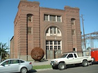
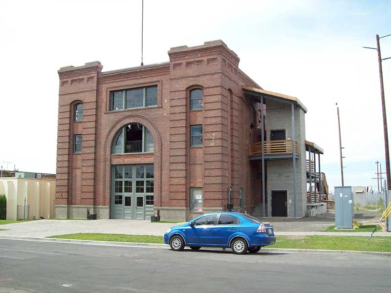
Construction of the Electric Building:
The oldest Sanborn fire map published for Walla Walla was 1884. The Walla Walla Gas Works was named and drawn on that map. It included a building on the Rose and Sixth Streets corner plus a coal shed and a round “gasometer” storage tank. In 1888 these three structures appeared the same and inside the main building was labeled “retort” and “purifier.” In the 1889 footprint a label in the corner building was added for ‘meter” and “20 hp engine.” The storage tank was now labeled “iron gas holder.” These structures were used for coal gas production (and are no longer present).
The 1890 fire map showed all these details plus a new building on the north side of the gas plant labeled “electric light wks,” with a footprint similar to the western portion of the present building (the only structure now remaining from the early Walla Walla Gas and Electric Company). The subsequent map in 1894 showed the same basic footprints but added details on the contents of the electric works building (4 dynamos, etc.). The 1905 map listed “Electric Transformers” in the eastern end of the building with “storage” in the west end. From 1905 until 1953 the fire maps were updated by way of cut-and-paste, as a result of which only a range of dates can be ascertained. The book of maps covering 1903 to 1923 showed a significant change in the electric building. It had an addition on the east end labeled “High Tension Sub Station” with fireproof construction, concrete floors, and the apparent date of “1911” that appears to match the east end of the current building. The center of the building was labeled “stm. turbines 1000 kw., Eng. Rm., Concr. floor, unprotected steel truss.” There was a length-wise wall/partition in this central portion that separated the “transformer room” from the steam turbines (see attached picture) that appears to match the currently existing non-load-bearing wall. The west end was separated from the central area by a wall with an opening in the middle. It was labeled “Boiler Rm.” This footprint and details were repeated unchanged on subsequent maps until the last firemap in September 1953. The adjacent gas works was also still present on the south side of this building in 1953.
Building permits exist in the Whitman Archives from 1907. Columbia Power and Light took out permit #867 on September 6, 1910 to build a “two story brick substation” on North Sixth between Rose and Sumach. The Walla Walla County Assessor’s Office lists a construction date of 1930. This has been disproved by both the legal records and the Sanborn Fire maps. Construction completion dates of 1890 for the brick west end and 1911 for the east end are justified by these records. The shell of this building remains in 2011, with prospects for restoration as a theatre.
References:
Bennett, Robert A., Walla Walla Portrait of a Western Town 1804-1899, Pioneer Press, Walla Walla, 1980.
Dierdorff, John, How Edison’s Lamp Helped Light the West, The Story of Pacific Power & Light and its Pioneer Forebears, Pacific Power & Light, 1971.
Gale Directory of Company Histories: PacificCorp http://www.answers.com/topic/pacificorp#ixzz1BG5r3E71
Sanborn Fire Maps: 1884-1905 (with updates until 1953).
Walla Walla City Directories: 1880-present (various publishers–not all years).
Walla Walla Chamber of Commerce local history time line:
Whitman College Archives.
The Walla Daily Union, 8/13/1925
The Walla Walla Union Bulletin, 7/13/1971, “Summer 1972”
Up-to-the-Times Magazine: Nov. 1906, Nov. 1910,
Mary E. Meeker ; Walla Walla 2020 Research Service January 2011


