Walla Walla 2020 and Beyond: Honoring, marking Walla Walla County’s historic sites
![]()
The following article is published in the Walla Walla Union-Bulletin’s series “Walla Walla 2020 and Beyond.” The full series of articles, published monthly, can be found at the UB’s site here.
Honoring, marking Walla Walla County’s historic sites
By DANIEL CLARK | Walla Walla 2020 and Beyond |
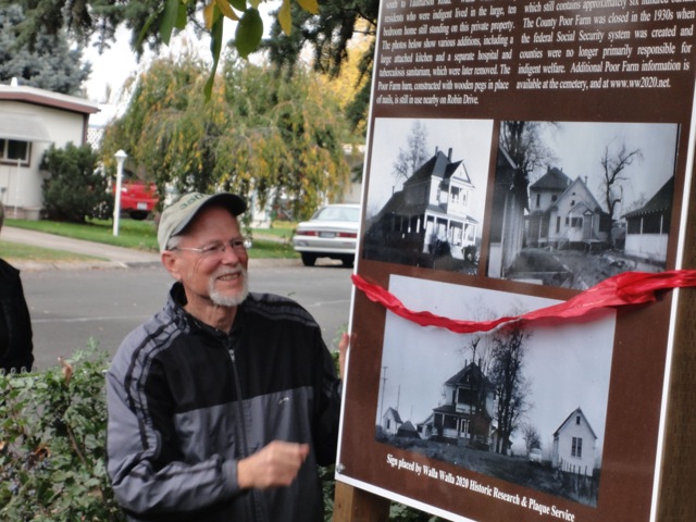
Walla Walla 2020’s Daniel Clark at the Poor Farm History Signage unveiling event.
In 2012, after researching and preparing plaques for the history of several dozen individual properties in our area, the Walla Walla 2020 Historic Research & Plaque Project I coordinate began looking to local sites important to the broader community, but whose history was often unknown.
Since then we have installed interpretive signage at over 20 historic sites of general significance and interest to residents and visitors. In 2019 we published “Historic Sites and Markers of Walla Walla County,” featuring 40 important local sites and a list of over 280 individual properties we’ve researched, together with an additional list of all National Historic Register properties in the county.
Our first project was the Walla Walla County Poor Farm and Poor Farm Cemetery, indicated on old College Place plat maps. The Poor Farm and cemetery were established by Walla Walla County in 1891 as a place where indigent residents could live, work, and be buried, and at one point included 200 acres extending from 12th Street south to Taumarson Road and just east of Myra Road to College Avenue.
The last burial and the closure of the farm was in about 1954, after the federal Social Security system was created and counties were no longer solely responsible for indigent welfare. Except for the cemetery, the land was sold and was a longtime dairy farm, before a manufactured home park went in there.
Over 700 deceased Poor Farm residents along with unclaimed remains from the Walla Walla County Coroner’s office were buried in the cemetery, mostly marked by small concrete cylinders bearing only a number, all which have been removed or have had grass planted over them. The last recorded burials took place in the early 1940s.
Ownership of the unmarked cemetery was transferred by Walla Walla County to the city of College Place in 1965. The city permitted Walla Walla 2020 to place a sign listing those buried there whose names were legible from the county’s cemetery records, discovered by 2020. Copies are on the 2020 website.
Our second project was another unmarked cemetery. Because of overcrowding at the city’s first Catholic cemetery established near the corner of Sixth Avenue and Alder Street in 1859, a plot of land known as the McCool Cemetery was dedicated as the Catholic Cemetery in 1867 and formally acquired in 1869. By 1891, after overcrowding, land for a new Catholic cemetery was purchased adjoining Mountain View municipal cemetery, and the church requested descendants of those buried at McCool to move all remains to the new site.
On Oct. 31, 1969, following removal of all grave markers by the church, the catholic bishop of Spokane sold the McCool Cemetery ground to developers, informing them all burials had been removed. However, during construction of the Pine Crest Village and Village Way development in the 1970s, remains from McCool burials were encountered in the street and on residential lots. More recently, professional archaeological excavations have documented the presence of additional burials inside and outside boundaries of the originally deeded cemetery.
Partial church records show 159 persons buried at McCool from October 1869-July 1872, and January 1884-October 1891 are not listed as reinterred at Mountain View Cemetery. Burial records from 1872-1883 were not available and are not included. The land comprising the McCool Cemetery is currently in four ownerships. The large eastern portion of the cemetery is owned by Traditions at Walla Walla, LLC, a Spokane-based firm that operates the adjacent Affinity retirement facility. Most of the western portion of the cemetery is owned by Pinecrest Village, Inc., which developed the adjacent condominiums and streets. Other than one private residence, the balance of the cemetery consists of a portion of the street and adjacent public right of way owned by the city of Walla Walla, where a WW 2020 interpretive sign lists the 159 persons not shown as reinterred, also listed on the WW2020 website.
Other important sites honored with Walla Walla 2020 interpretive signs include Davies Community and Walla Walla Jesus site at Scenic Loop and Mormon Grade, Wallula Historic Site at Wallula Gap, Mullan Road Historic Site at 13th Avenue and Abadie Street, Chinatown at Fourth Avenue and Rose Street, Germantown site at Chase Avenue and Morton Street, Treaty Council of 1855 at Alder and Poplar streets, Edgewater Park Dance Pavilion at Heritage Park, Stevens Skirmish site on the Mill Creek levee near Reservoir Road and the Civilian Conservation Corps camp on Mill Creek Road west of Five Mile, along with nine others.
A free map of all of the Walla Walla 2020 historic sites, along with 20 additional sites marked by others, produced by 2020 and printed by Visit Walla Walla, is available where tourism materials are found and on the WW 2020 website. Copies of “Historic Sites & Markers of Walla Walla County” are at local bookstores and online sellers. All proceeds support WW 2020’s history work. More information on all of the sites featured are at ww2020.net/historic-sites.


