History of 603 East Cherry Street, Walla Walla, WA
Legal Description
Walnut Grove Lots 2 & 3 & 4, Blk. 10; Tax 1 Lot 4, Blk. 10
Full Legal Description
Lots 2, 3 and 4 in Block 10 of Walnut Grove Addition to the City of Walla Walla, according to the official plat thereof of record in the office of the Auditor of Walla Walla County Washington. Also, beginning at the most Easterly corner of Lot 4 in Block 10 of Walnut Grove Addition aforesaid, and running thence North 37° 07’ East, along the Northwesterly line of Cherry Street, a distance of 12 feet; thence South 37° 07’ West to the point of intersection with the produced Southeasterly line of the alley in said Block 10; thence South 37° 07’ West, along said produced alley line, to a point in the North line of said Block 10; thence Easterly along the North line of said Block 10 to the point of beginning. Subject to easements and rights of way of record.
Title and Occupant History
Washington Territory was created in 1853. In 1854, the new territorial legislature created Walla Walla County, which stretched from the crest of the Cascade Mountains to the crest of the Rocky Mountains in the present states of Washington, Idaho and Montana. In 1855, Isaac Stevens, governor of Washington Territory, held a council on the banks of Mill Creek at the present site of Walla Walla with representatives of regional Indian tribes to purchase land from them. The Yakamas, Cayuses and Walla Wallas were dissatisfied with the treaties and the intrusion by whites into their lands before the treaties’ ratification, and war followed. Missionaries, former French-Canadian employees of the Hudson Bay Company trading post at Wallula, and soldiers at the military Fort Walla Walla were the primary European occupants of the area prior to 1859, when the treaties were finally ratified and the land was opened for settlement. The transfer of ownership occurred by virtue of a treaty signed on June 9, 1855 in Walla Walla and ratified on March 8, 1859 by President James Buchanan, in which all of the land in the Walla Walla area was acquired from the Cayuse and Walla Walla Indian tribes.
The town of Walla Walla was originally laid out by County Surveyor Hamet Hubbard Case in 1859, prior to its formal incorporation as a city in 1862, as a one-quarter mile square with its eastern side centered on the point where Main Street crossed Mill Creek (at roughly the point where it does now).
The original plat was lost, probably in the fire of 1865. Thus, the earliest plat on file is one made by W. W. Johnson, City Surveyor, in July 1865 that claims to have made corrections to Case’s survey. Johnson’s survey was made the official plat of the City of Walla Walla on September 25, 1866, was filed and recorded July 5, 1867.

Plat Map of Walnut Grove Addition. 603 E. Cherry is at upper left. Note the pond that formerly was east of the house. Also note Butcher Creek, now dry, running from the upper right corner. It appears to go underground across Cherry Street, and may have fed the former pond.
Walnut Grove Addition to the City of Walla Walla was filed by John F. and Sarah E. Boyer on 5/2/1892, described as follows, to wit: commencing at a point on the center line of Oak Street 380 feet Northeasterly from the intersection of the center line of said Oak Street with the center line of Idaho Street [now Park Street] 89528/100ths feet; thence deflect 38° left or Easterly a distance of 285 feet; thence 90° 20’ left, or Northerly, 526¼ feet; thence Westerly in a straight line to the place of beginning. Walnut Grove Addition contained eight blocks of varying sizes subdivided into 79 building lots, and three undivided blocks.
9/10/1861, A. J. Cain and Cornelius Kelly filed a claim through the Olympia, W.T. Land Office for 160 acres in Section 20, Township 7-North, Range 36-East under the Scrip Warrant Act of 1855. Cain was elected on the Democratic ticket as prosecuting attorney of Walla Walla County in 1868. Although defeated in 1870, District Court Judge James Kennedy ruled that Cain could complete his full two-year term, thus denying the winner, N. J. Caton, his right to occupy the office until 1871.
2/14/1862, Mortgage, A. J. and Emma R. Cain, mortgagers; A. H. Reynolds, mortgagee, the Southwest quarter of Northeast quarter, the Southeast quarter of Northwest quarter, the Northwest quarter of Southeast quarter and the Northeast quarter of Southwest quarter of Section 20 in Township 7-North, of
Range 36-East, including this property, with the exception of the building sites sold to and occupied by Messrs. Way & Bush, Geo. E. Cole, and [Mr.] Seaman, James McAuliff and Dr. Danforth, and the building lots sold as follows, to wit: in Block 1 one lot to W. H. Patton and A. Dodge, four lots to Way & Bush & Co., two lots to Allen Thibido and [Mr.] Schafer, in Block 3 one lot to W. H. Morrison, in Block 5 one lot to Brooks & Cranston, in Block 6 one lot to C. H. Armstrong, one lot to Brooks & Cranston, and two lots to G. C. Robbins; also property in Cain’s Addition to the City of Walla Walla, $1 to secure a note for $1,000. A. H. Reynolds (b. 1808 New York State; d. 1889 Walla Walla) arrived in Walla Walla in 1859. Although involved earlier in building grist and woolen mills, in 1874 he collaborated with Dr. I. H. Day and constructed the Reynolds-Day Building, beautifully restored on East Main Street. Dr. Day operated a pharmacy in half of the street level and Reynolds established the first bank in Walla Walla in the other half.
11/18/1867, Sheriff’s Deed, A. Seitel, Sheriff of Walla Walla County, W.T. to Dorsey S. Baker, the Southwest quarter of the Northeast quarter and the Southeast quarter of the Northwest quarter, and the Northwest quarter of the Southeast quarter and the Northeast quarter of the Southwest quarter of Section 20 in Township 7-North of Range 36-East, including this property, excepting such blocks and building lots as have been by proper and legal conveyances heretofore sold and transferred, to wit: Blocks A, B, C, D and nos. 1, 2, 3, 5, 6 and 40 and Lots 6 and 7 in Block 7 and building lots sold to the following named persons, to wit: Way & Bush, George E. Cole, William Wightman, J. F. Boyer, Sarah Virginia Armstrong and the lands sold and deeded to D. S. Baker on the 5th day of December 1864, $2,800.
10/20/1871, Deed, Andrew J. and Emma R. Cain, grantors; Dorsey S. Baker, grantee, the Southwest quarter of the Northeast quarter and the Southeast quarter of the Northwest quarter and the Northwest quarter of the Southeast quarter and the Northeast quarter of the Southwest quarter of Section 20 in Township 7-North of Range 36-East of the Willamette Meridian, including this property, excepting the following blocks, lots and parcels of land, to wit: Blocks A, B, C, D and nos. 1, 2, 3, 5, 6 and 40, and Lots 6 and 7 in Block 7 and also excepting certain building lots heretofore sold and conveyed by the parties of the first part to the following persons, to wit: Way & Bush, George E. Cole, William Wightman, John F. Boyer and Sarah Virginia Armstrong, $1.
Dr. Dorsey Singh Baker might easily be called the most instrumental person who defined Walla Walla during its early years. He was born in Illinois in 1823 and graduated in 1845 with a medical degree from Jefferson College in Philadelphia. He determined to head west in 1848, arriving in Portland in September. He headed to the California gold fields in 1850, returning to Portland that same year and forming a partnership with L. B. Hastings operating a hotel and store. Dr. Baker also practiced medicine. He returned to California, residing in Oakland for seven years. In 1858 he returned to Portland, but by 1860 had moved to Walla Walla where he started a mercantile establishment. His brother-in-law, John F. Boyer, arrived in Walla Walla in 1862 and assumed responsibility for the mercantile branch of Baker’s business. There is far too much to record here about Dr. Baker, his involvement in shipping and railroads, but on 11/10/1869, Baker and Boyer formed the Baker-Boyer National Bank, the first independently-operated bank in Washington Territory. Dorsey Baker died in 1888. John F. Boyer was born in Kentucky in 1824, but raised in Indiana. Like his brother-in-law, he migrated to California, but agreed to a partnership with Dorsey Baker in Walla Walla in 1862. He died in Walla Walla in 1897.
9/23/1886, Warranty Deed against grantor, Dorsey S. and Elisabeth H. Baker, grantors; John F. Boyer, grantee, commencing at a point on the center line of East Oak Street, 380 feet Northeasterly from the intersection of the center line of East Oak Street with the center line of North Touchet Street, thence Southeasterly and parallel with the center line of North Idaho [now Park] Street 89528/100ths feet; thence deflect 38° left (Easterly) a distance of 285 feet; thence 90° 20’ left (Northerly) 526¼ feet; thence 80° 51’ left (Westerly), 988 ¼ feet, to the place of beginning, containing 7 and 73/100ths acres, more or less. Also, a piece or parcel of land described as follows, to wit: commencing at a point on the South line of the Northwest quarter of the Southeast quarter of Section 20, Township 7-North, of Range 36-East of the Willamette Meridian 3725/10ths feet West of the stone monument at the intersection of said line with the center line of Park street, thence West along said South line of the Northwst quarter of the Southeast quarter 24428/100ths feet; thence North at a right angle 36647/100ths feet; thence deflect 74° 541/2’ right a distance of 2535/100ths feet; thence South 43230/100ths feet, to the point of beginning, containing 2 and 23/100ths acres more or less. Also, a piece of parcel of land described as follows, to wit: commencing at a point on the South line of the Northwest quarter of the Southeast quarter of Section 20, Township 7North, or Range 36-East of the Willamette Meridian 61678/100ths feet West of the stone monument at the intersection of said South line of the Northwest quarter of the Southeast quarter with the center line of Park Street, thence West along the said South line of the Northwest quarter of the Southeast quarter 158 25/100ths feet; thence North at right angels 11062/100ths feet; thence deflect 25° 45’ right (Easterly) 25° 45’ right (Easterly) 260 feet; thence East, parallel with the South line of the Northwest quarter of the Southeast quarter 4531/100ths feet; thence South 3448/10ths feet, to the place of beginning, containing 94/100ths of an acre, more or less, including this property. Also property in Cain’s Addition.
6/4/1897, Warranty Deed, Eugene H. Boyer and John E. Boyer, as executors of the Last Will & Testament of John F. Boyer, deceased, grantors; David N. Cox, grantee, Lot 2, Block 10, Walnut Grove Addition, $200. David Cox resided on Valley Grove Road in the 1898 Walla Walla City Directory. The 1900-01 directory only listed Mrs. David Cox in Waitsburg as proprietor of Waitsburg Boarding & Lodging House on Main between 2nd and 3rd, with rooms from 25¢ to 50¢, and featuring home cooking. This is the first conveyance limited to this property.
6/30/1898, Warranty Deed, Eugene H. Boyer, grantor; Sarah Imogen Boyer, grantee, all property… belonging to the Estate of John F. Boyer, deceased… and all rents, issues and profits thereof, $1.
4/1/1901, Warranty Deed, David N. and Lillie M. Cox, grantors; P. J. Pentecost, grantee, Lot 2, Block 10, Walnut Grove Addition, $250. Phillip J. Pentecost was a farmer residing initially at 141/2 East Main Street. He was listed as residing at 603 East Cherry Street in the 1900-01 Walla Walla City Directory, the first listed occupancy at that address.
4/1/1901, Warranty Deed, Eugene H. Boyer and John E. Boyer, as Executors of the Last Will & Testament of John F. Boyer, deceased, also Sarah E. Boyer, widow, Arthur A. Boyer, Annie I. Norton and Sarah I. Boyer, grantors; P. J. Pentecost, grantee, Lots 1, 3 and 4 of Block 10, Walnut Grove Addition, $300. Through 6/20/1903 negotiations followed over dividing the estate of John F. Boyer, including property in both Walla Walla and Garfield Counties, among the various family members.
4/25/1929, Certificate of Water Right, State of Washington to Phillip J. Pentecost, to use waters of Butcher Creek for irrigation on Lot 2, and fractional Lots 1, 3 and 4, Block 10, Walnut Grove Addition. 5/17/1937, Agreement, P. J. and Cora L. Pentecost, to establish all property owned by them to be community property, $1 paid by each to the other, and for love and affection.

Plat Map of Walnut Grove Addition. 603 E. Cherry is at upper left. Note the pond that formerly was on Lots 3 and 4. Also note Butcher Creek running from the upper right corner. It appears to go underground across Cherry Street, and may have fed the former pond on Lots 3 and 4.
10/26/1945, Warranty Deed, The Baker-Boyer National Bank, as Executor of the Last Will & Testament of Cora L. Pentecost, deceased, grantor; E. B. and Anna Lutton, grantees, Lots 2, 3 and 4, Block 10, $5,500. Paul Lutton was listed in the 1946 city directory living at 603 East Cherry Street.
6/5/1951, Warranty Deed, E. B and Anna Lutton grantors; Paul E. and Flora Mae Lutton, grantees, Lots 2, 3 and 4, Block 10, $10.
10/1/1954, Warranty Deed, Paul E. and Flora Mae Lutton, grantors; Leo G. and Ethel E. Hagen, grantees, Lots, 2, 3 and 4, Block 10, $10 and other valuable consideration. Leo and Ethel Hagen could not be located in 1954 or 55 city directories. The 1954 reverse directory listed Roy Powell, a renter and driver for Donald Duck Bakery, living at 603 East Cherry Street. The reverse directory for 1955 listed 603 East Cherry as vacant.
3/14/1958, Statutory Warranty Deed, Leo G. and Ethel E. Hagen, grantors; Glenn D. and Shirley D. Bragg, grantees, Lots 2, 3 and 4, Block 10, $10. The Braggs were listed in the city directory for 1958 as residing at 603a East Cherry Street. Bragg was a salesman for Rena-Ware.
9/30/1966, Warranty Deed, Glenn D. and Shirley D. Bragg, grantors; Joseph L. and Hazel D. Lytle, grantees, Lots 2, 3 and 4, Block 10. Joseph Lytle was a teacher at Wa-Hi; Hazel Lytle was employed by Birdseye Frozen Foods.
10/17/1966, Real Estate Contract, Glenn D. and Shirley D. Bragg, grantors; Joseph L. and Hazel D. Lytle, grantees, Lots, 2, 3 and 4, Block 10.
2/26/1971, Deed and Purchaser’s Assignment of Real Estate Contract, Joseph L. and Hazel D. Lytle, grantors; Veta Stover Smyth, a single woman, grantee, Lots 2, 3 and 4, Block 10. Mrs. Veta Smyth did not live at 603 East Cherry Street; she resided at 818 Hobson Street. Byron B. Johnson was listed in the reverse directory living at 603 East Cherry as a renter., employed in the camera department of Thrifty Mart. His wife, Susan, was employed as a secretary at the Union-Bulletin.
4/20/1976, Purchaser’s Assignment of Contract and Deed, William M. Birdsong, Jr. and Grace E. Birdsong, formerly Grace E. Leonetti, grantors; convey and quit claim to Douglas J. and Virginia K. Wahner, grantees, Lots 2, 3 and 4. The relationship between either Birdsong/Leonetti or Veta Smyth could not be established. Grace Birdsong and a Sam Birdsong resided at 603 East Cherry Street; William M. Birdsong, Jr. could not be located in a city directory. The Wahners resided at 603 East Cherry Street, as did renters Steve M. Irwin and Mike Jorskowsky in Unit B.
3/16/1978, Deed and Seller’s Assignment of Real Estate Contract, Veta Stover Smyth, a single woman, grantor; Baker-Boyer National Bank, as Trustee of Veta Stover Smyth Trust Fund dated 3/16/1978, grantee, Lots 2, 3 and 4, Block 10 to transfer Real Estate Contract of 8/15/1974 between Veta Stover Smyth, a widow and Grace E. Leonetti, a divorced woman. The reverse city directory for 1978 listed Rosalee Haskell as a renter in Unit B.
8/13/1985, Special Warranty Deed, Baker-Boyer National Bank, as Trustee for Veta Stover Smyth, grantor; Douglas J. and Virginia K. Wahner, grantees, Lots 2, 3 and 4, Block 10, $14,500.
6/9/2005, Quit Claim Deed, Douglas J. Wahner in consideration of settlement of dissolution of marriage, grantor; Ginger K. Wahner, grantee, Lots 2, 3 and 4, Block 10.
4/29/2009, Quit Claim Deed, Virginia K. Wahner Thronson, AKA Ginger K. Wahner, grantor; Phillip H. Wahner, grantee, Lots 2, 3 and 4, Block 10, for love and affection.
6/29/2022, Statutory Warranty Deed, Virginia K. Thronson, as her separate estate, and Phillip A. Wahner, as his separate estate, grantors; Kyle I. and Stephanie R. Wood, grantees, Lots 2, 3 and 4, Block 10.
9/13/2002, Quit Claim Deed, Virginia K. Thronson, as her separate estate, and Phillip A. Wahner, as his separate estate, grantors; Kyle I. and Stephanie R. Wood, grantees, beginning at the most Easterly corner of Lot 4 in Block 10 of Walnut Grove Addition and running thence North 37° 07’ East, along the Northwesterly line of Cherry Street a distance of 12 feet; thence South 89° 07’ West to the point of intersection with the produced Southeasterly line of the alley in said Block 10; thence South 37° 07’ West, along said produced alley line, to a point in the North line of said Block 10; thence Easterly along the North line of said Block 10 to the point of beginning.
Construction of Building

The first edition of the 1905 Sanborn Fire Insurance Map shows 603 East Cherry Street in the upper left block. Note the outbuilding at the upper left corner. N. Idaho Street is now Park Street.
The 1905 edition of the Sanborn Fire Insurance Map is the first one to extend east on East Cherry Street beyond Park Street; the 1894 Sanborn map only extends through the 500 block of East Cherry, i.e., it stops at the west side of Park Street.
The Walla Walla Assessor’s Office dates the house at 603 East Cherry Street to 1898. Assessor build dates are most often estimates based on the building’s appearance. Building permits for the City of Walla Walla preserved at Whitman College Archives only date back to mid-September 1907; thus no build date could be established for this house. Its appearance might date the house to 1898 as easily as it could to the first few years of the 20th century. The still young city of Walla Walla was an architectural outlier at the turn of the last century, not always as stylish and up to date architecturally as larger Midwest and East Coast cities – or San Francisco for that matter.
In 1898, David and Lillie Cox owned Lot 2 of Block 10 in Walnut Grove Addition, but they could not be connected to a house on the property. David resided at what was then considerably north of Walla Walla, and Mrs. Cox operated a boarding lodge in Waitsburg. In 1901, the Coxes sold Lot 2 to farmer Phillip J. and Cora Pentecost. The 1900-01 City Directory listed the Pentecosts residing at 603 East Cherry Street, the first purchasers of the property shown to have resided there. It is important to note that 1901 was the filing date for the Warranty Deed; the actually sale of the property was consummated 10/14/1899. Thus, the most likely date for the construction of the house at 603 East Cherry Street was 1900.

The 1905 Sanborn map with early additions is more clear than the black and white map. Note that the outbuilding in the upper left corner of Lot 2 has been pasted over, indicating that it was no longer there. Also notice Butcher Creek snaking from the upper right corner ending at E. Cherry where presumably it was in a culvert under the street. It would be hard to consider that it did not connect with the large pond adjacent to 603 East Cherry Street to provide irrigation.
From Prof. W. D. Lyman’s history of Walla Walla (see Resources below), Philip J. Pentecost was born in Dodge County, Wisconsin, December 13, 1856, a son of William C. and Jemima (Wilcox) Pentecost, the former a native of Somersetshire, England, while the latter was born near Utica, New York. The father came to the United States at age 14 in company with his parents and settled in New York, where he afterward married. Two children were born to him and his wife in the Empire state.
Phillip Pentecost first moved to Dodge County, Wisconsin, and in the spring of 1875 became a resident of Seattle, Washington Territory. Soon afterward he went to Portland, Oregon, and still later to Albany, where he and his wife spent the summer. In the following fall they came to Walla Walla, looking for a suitable location. The following spring, however, they returned to Seattle, where they remained for a few weeks and then returned to Forest Grove, Oregon. During their perambulations they managed through their work to get together a spike team, consisting of three horses, one leading other two, and after spending the summer in Forest Grove they again came to Walla Walla, driving through by team.
In the spring of 1877, Mr. Pentecost, Sr. purchased a tract of four hundred acres of choice land located in Spring Valley, about eight miles northeast of the city, on the Waitsburg road. He contracted for this land for seven dollars per acre, to be paid for with wheat at fifty cents per bushel.
This land was afterward paid for by Philip J. Pentecost and an older brother, Charles N., and thus came into their possession. For thirty years the two brothers cooperated in their farming enterprise and in the meantime added to their holdings until the place comprised 1,000 acres. In time Philip J. Pentecost purchased his interest in the Walla Walla County farm, which he owned independently. He also had 400 acres on Blue Creek which is largely grazing land and on which he ran as high as a hundred head of cattle at a time.

Philip J. Pentecost and Cora Nellie Wolfe Pentecost
[In] 1901, he left the farm and took up residence in the city in order to give his children better educational opportunities, with residence at 603 Cherry Street. He also owned four other city residences. For seven years he rented his farm lands and practically lived retired. On the 29th of June, 1889, Mr. Pentecost was united in marriage to Mrs. Joseph Maul, who bore the maiden name of Nellie Wolfe and is a daughter of Harry Wolfe, who crossed the plains to Washington with a horse team in 1888.
By her first husband Mrs. Pentecost had a daughter, Catherine Z. M., and to Mr. and Mrs. Pentecost was born a daughter, Sadie R., who became the wife of A. E. Page, of Walla Walla.
Mr. Pentecost’s political affiliation was with the Republican party. He and his wife and daughter were members of the Baptist church, of which he was a deacon and trustee for years. The family was prominent in Walla Walla. Mr. Pentecost enjoyed a very creditable position in business circles, ranking for many years as one of the leading wheat growers of this section of the state.
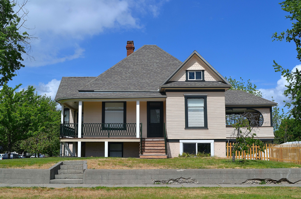
The house at 603 East Cherry Street most closely reflects the restrained Queen Anne style with its steeply pitched central hip roof and projecting gables on the sides. The one on the right is a later addition that provides cover for an open porch partially enclosed with latticework. The house is one and one-half stories. The main floor is elevated considerably, affording natural light to the lower level. One wonders what determined this. It may have been planned to be a deterrent to possible disaster should Butcher Creek and/or the former large pond on the property flood. It is something that likely will never be known for certain. Evidently it did provide space for renters from time to time.
This is an attractive house with its clapoard siding at the first level, fishscale shingles in the gable ends, a modicum of Victorian embellishments remaining (one must assume that more ornamentation likely existed when the house was new). Although a recent addition, the decorative iron railing around the wrap-around front and side porch tends to mimic turn-of-the-last-century wrought iron work quite successfully. Supporting porch posts are square; the original posts doubtless were round.
Resources
- TitleOne Title & Escrow (formerly Pioneer Title)
- Whitman College Archives
- Sanborn Fire Insurance Maps
- Walla Walla City Directories
- Gilbert, Frank T., Historic Sketches of Walla Walla, Whitman, Columbia and Garfield Counties, Washington Territory, also Umatilla County, Oregon, A. G. Walling, Portland, 1882
- Lyman, Prof. William Dennison, Lyman’s History of Old Walla Walla County Embracing Walla Walla, Columbia, Garfield and Asotin Counties, Vol. 1, S. J. Clarke Publishing Company, Chicago, 1918
- The Washington Standard, 4/26/1889


