History of 528 Craig Street, Walla Walla, WA
Legal Description
PARCEL A: Beginning at the Northwest corner of Section 28, Township 7-North, Range 36-East of the Willamette Meridian and running thence South 0° 0’ 0” West, along the West line of Section 28, a distance of 427.50 feet; thence North 89° 49’ 00” East, parallel to the North line of said Section, a distance of 215.00 feet to the true point of beginning for this description; thence South 0° 00’ 00” West parallel to the said West line 97.50 feet; thence North 89° 49’ 00” East, parallel to the aforesaid North line of Section 28, a distance of 30.00 feet; thence North 0° 0” 0’ East, parallel to the said West line of said Section 10.80 feet to a point in a line parallel to and 150.00 feet North of the North line of Pleasant Street in the City of Walla Walla; thence North 89° 49” 00’ East, along said parallel line 97.50 feet; thence North 0° 0” 0’ East, parallel to the West line of said Section 28 a distance of 168.67 feet to a point in the South line of Craig Street in said City; thence South 89° 49” 00’West, along said South line 94.70 feet to a point in a line parallel to and 215.00 feet East of the East line of Howard Street in said City; thence South 0° 0” 0’ West along said parallel line 82.00 feet; thence South 89° 49” 00’ West, parallel to the North line of the aforesaid Section 28, a distance of 30 feet to the true point of beginning.
PARCEL B: Also Tract 8 of Short Plat filed October 3, 1985 in Volume 2, Page 79 of Short Plats, under Auditor’s File no. 8506896, Records of Walla Walla County, Washington.
EXCEPTING THEREFROM the West 44.74 feet thereof.
Situated in the City and County of Walla Walla, State of Washington.
It should be noted that the property currently comprising 528 Craig Street consists of the main parcel and two short plats; however, the Assessor has combined the two short plats.
Title and Occupant History
Washington Territory was created in 1853. In 1854, the new territorial legislature created Walla Walla County, which stretched from the crest of the Cascade Mountains to the crest of the Rocky Mountains in the present states of Washington, Idaho and Montana. In 1855, Isaac Stevens, governor of Washington Territory, held a council on the banks of Mill Creek at the present site of Walla Walla with representatives of regional Native tribes to purchase land from them. The Yakamas, Cayuses and Walla Wallas were dissatisfied with the treaties and the intrusion by whites into their lands before the treaties’ ratification, and war followed. Missionaries, former French-Canadian employees of the Hudson Bay Company trading post at Wallula, and soldiers at the military Fort Walla Walla were the primary European occupants of the area prior to 1859, when the treaties were finally ratified and the land was opened for settlement. The transfer of ownership occurred by virtue of a treaty signed on June 9, 1855 in Walla Walla and ratified on March 8, 1859 by President James Buchanan, in which all of the land in the Walla Walla area was acquired from the Cayuse and Walla Walla tribes.
The town of Walla Walla was originally laid out by County Surveyor Hamet Hubbard Case in 1859, prior to its formal incorporation as a city in 1862, as a one-quarter mile square with its eastern side centered on the point where Main Street crossed Mill Creek (at roughly the point where it does now).The original plat was lost, probably in the fire of 1865. Thus, the earliest plat on file is one made by W. W. Johnson, City Surveyor, in July 1865 that claims to have made corrections to Case’s survey. Johnson’s survey was made the official plat of the City of Walla Walla on September 25, 1866, was filed and recorded July 5, 1867.
528 Craig Street is situated on a portion of 40 acres granted to Thomas Cantrill (sometimes spelled Cantrell) in a United States Patent, as recorded on 4/1/1865 in the Vancouver, W.T. District Land Office.
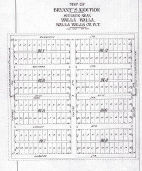
Bryant’s Addition to the City of Walla Walla was filed 9/15/1880. It included the “South ½ of the North West ¼ of Section 28, Township 7-North, Range 30-East of the Willamette Meridian and the North ½ of the South West ¼ of the North West ¼ of the same section”.
3/29/1886, Lease, Mrs. Viretta Bryant, lessor to “Lee Wah and Sam (two Chinamen)”, lessees, beginning at a point on the North side of Pleasant street in Bryant’s Addition to the City of Walla Walla distant 85 feet East from the North East corner of Howard and Pleasant streets running thence North 140 feet; thence East 165 feet; thence North 80 feet; thence West to the East line of said Howard Street; thence Northerly along East line of Howard Street to the stable lot; thence East the length of the stable lot; thence North the width of the stable lot; thence East to the West line of Division Street; thence South along the West line of said Division Street to the North side of said Pleasant Street; thence West along the North line of said Pleasant Street to the place of beginning, for the term commencing March 1, 1886 and expiring March 1, 1891, for the sum of 100 dollars gold coin of the United States per year for the first two years and 110 dollars for the last three years. The lessees were Chinese produce farmers, among many to whom the Bryants leased portions of their land.
5/11/1901, Indenture, John and Viretta Bryant, grantors; J. K. Wilson, grantee, beginning at a point on the West line of Section 28, Township 7-North, Range 36 East of the Willamette Meridian 264 feet South of the South line of Whitman street, running thence South on said section line 130 feet; thence East to a point 105 feet West of the West line of land sold by the parties of the first part hereto to Daniel Stewart January 9th, 1897; thence South 237 and one-half feet to Pleasant Street in Bryant’s Addition of the City of Walla Walla; thence East along the North line of Pleasant Street 105 feet; thence North 370 and one-half feet; thence West to the point of beginning, $1,385 in gold coin.
1/6/1907, Warranty Deed, Viretta Bryant, a widow, grantor; John R. Fitzhugh, grantee, commencing at a point 185 feet at right angles East from a point on the Easterly line of Howard Street 287.5 feet North from the North-west corner of Block no. 1 of Bryant’s Addition to the City of Walla Walla; running thence South 97.5 feet; thence at right angles East 30 feet; thence at right angles North 97.5 feet; thence at right angles West 30 feet to the place of beginning. Also the right of ingress and egress to and from the said described property over that certain tract of land described as follows: commencing at a point 40 feet West of the South West corner of the said described premises running thence East 40 feet; thence at right angles North 40 feet; thence South Westerly in a straight line to the place of beginning, $1.
5/19/1908, Warranty Deed, John R. and Minnie C. Fitzhugh, grantors; Herbert D. G. Cox, grantee, commencing at a point 50 feet North of the North-west corner of Block no. 1 of Bryant’s Addition to the City of Walla Walla, running thence East 155 feet; thence at right angles North 128 feet; thence at right angles East 60 feet; thence at right angles North 12 feet; thence at right angles West 70 feet; thence at right angles South 656 feet; thence at right angles West 145 feet; thence at right angles South 75 feet to the place of beginning. Also commencing at a point 185 feet at right angles East from a point on the Easterly line of Howard street 287.5 feet North from the North-west corner of Block no. 1 of Bryant’s addition to the City of Walla Walla; running thence South 97.5 feet; thence at right angles East 30 feet; thence at right angles North 97.5 feet; thence at right angles West 30 feet to the place of beginning. Also the right of ingress and egress to and from the last above described property over that certain tract of land described as follows: commencing at a point 40 feet West of the South-west corner of the said last above described premises; running thence East 40 feet; thence at right angles North 40 feet; thence South-westerly in a straight line to the place of beginning, $7,000.
9/2/1909, Indenture, J. K. and Amy F. Wilson, grantors; Winnie L. Wilson, grantee, beginning on the East line of Howard Street 264 feet South of the South line of Whitman Street; thence East at right angles 630 feet; thence South at right angles 36 feet; thence East at right angles 379.5 feet; thence South at right angles 184 feet; thence West at right angles 794 feet; thence North at right angles 170 feet; thence West at right angles 215.7 feet to the East line of Howard street; thence North 50 feet to the place of beginning, $1.
12/8/1913, Indenture, Winnie L. Wilson, a spinster and Edna D. Wilson, a spinster, grantors; Amy F. Wilson, grantee, same legal description as Indenture of 9/2/1909, $1.
8/25/1937, Quit Claim Deed, Amy F. Wilson, a widow, grantor; City of Walla Walla, a municipal Corporation, grantee, beginning on the North line of Pleasant Street in the City of Walla Walla, 409.7 feet East of the East line of Howard Street; thence East along said North line of Pleasant Street 55 feet; thence North at right angles 150 feet; thence West at right angles 55 feet; thence South 150 feet to the place of beginning. Also includes the legal description in the Indenture of 9/2/1909, $10.
12/31/1937, Quit Claim Deed, City of Walla Walla, a municipal corporation, by Dorsey M. Hill, Mayor, Ray Appling, City Clerk, grantor; W. E. and Alta Burgner, grantees, beginning at a point in a line drawn parallel to and distant 315.5 feet South of the South line of Whitman Street, said point of beginning being 215 feet Easterly from the East line of Howard Street; running thence Easterly along said parallel line a distance of 249.7 feet; thence Southerly along a line parallel to the East line of Howard Street a distance of 168.59 feet, more or less, to a point in a line parallel to and distant 150 feet North of the North line of Pleasant Street; thence Westerly parallel to the North line of Pleasant Street a distance of 249.7 feet; thence Northerly parallel to the East line of Howard Street, a distance of 168.7 feet, more or less, to the point of beginning. Excepting therefrom the following-described tract: beginning at a point in a line drawn parallel to and distant 315.5 (considerable language is missing from the typed quit claim deed beginning at this point and commencing as followed in abbreviated language): the City of Walla Walla since acquiring said title has paid into Local Improvement District Fund delinquent assessments for which the property was sold including accrued interest; the City holds the title to said property; W. E. and Alta Burgner have offered to pay the sum of $435 in cash; it is in the best interests of the City to sell the property for that amount; be it resolved that the Mayor and the City Clerk are authorized to execute a quit claim deed to W. E. and Alta Burgner, $435.
2/14/1939, Warranty Deed, Herbert D. G. Cox, a widower, grantor; May Lucinger, grantee, beginning at the point of intersection of the East line of Howard Street with the North line of Pleasant Street; running thence East along the said North line of Pleasant Street 155.0 feet; thence North parallel to the East line of Howard Street a distance of 130.15 feet; thence East parallel to the North line of Pleasant Street a distance of 60 feet; thence North parallel to the East line of Howard Street a distance of 109.5 feet; thence West parallel to the North line of Pleasant Street a distance of 30 feet; thence South parallel to the East line of Howard Street a distance of 97.5 feet; thence West parallel to the North line of Pleasant Street a distance of 40 feet; thence South parallel to the East line of Howard Street a distance of 65 feet; thence West parallel to the North line of Pleasant Street a distance of 145.0 feet to a point in the East line of Howard Street; thence South along the East line of Howard Street a distance of 75 feet, more or less, to the point of beginning. Also the right of ingress and egress to and from said lands over the following described tract: commencing at a point 190 feet North and 145 feet East of the Northwest corner of Block 1 of Bryant’s Addition to the City of Walla Walla, Washington, according to the official plat thereof of record in the office of the Auditor of said County of Walla Walla, and running thence East 40 feet; thence at right angles North 40 feet; thence Southwesterly in a straight line to the place of beginning, $10.
12/8/1939, Warranty Deed, Maude Wendel, a spinster, grantor; Mary M. Mills, a widow, grantee, same legal description as in Warranty Deed of 2/14/1939, $10.
7/10/1940, Quit Claim Deed, Earney C. Mills, formerly the husband of the grantee herein, grantor; Mary M. Mills, a widow, grantee, same legal description as in Warranty Deed of 2/14/1939, less the right of ingress and egress, $1.
10/17/1941, Warranty Deed, W. E. and Alta Burgher, grantors; Allen L. and Evelyn J. Reynolds, grantees, same legal description as in quit claim deed of 12/31/1937, $10.
2/23/1943, Warranty Deed, Mary McKinney, formerly Mary M. Mills, grantor; Frances M. Lowden, a single woman, grantee, beginning at the Northwest corner of Section 28 in Township 7-North, of Range 36East of the Willamette Meridian, running thence South on the West line of said Section 28 a distance of 427.5 feet; thence East parallel to the North line of said Section 28 a distance of 215 feet to a point which is the true point of beginning. From that true point of beginning so ascertained, running East 30 feet, thence South per the West line of Section 28 a distance of 97.5 feet; thence West 30 feet; thence North 97.5 feet to the point of beginning. The relevance of this warranty deed to 528 Craig Street may be seen in the next two quit claim deeds and the statutory warranty deed of 10/11/19385.
6/27/1970, Quit Claim Deed, Frances Mattie Lowden Borgens, whose husband is George Borgens, as her separate property, grantors; Lillian and Harold Banks, grantees, beginning at a point in the East line of Howard Street, which point is 427.5 feet South and 30 feet East of the Northwest corner of Section 28 in Township 7-North, of Range 36, East of the Willamette Meridian, running thence East 215 feet; thence North 82 feet; thence West 215 feet to said East line of Howard Street; thence South along said East line 82 feet to the point of beginning. George Borgens joins herein to confirm of record that he never did have any interest in the above property. This quit claim deed is not yet relevant to the property addressed in this report, but the grantee, Lillian Banks, deeded it to Allen and Evelyn Reynolds on 10/11/1985 as a short plat that probably allowed the Reynolds to expand their house (see Construction of Building following).
12/8/1970, Quit Claim Deed, Frances Mattie Borgens, and George Borgens, her husband, grantors; Lillian Banks, whose husband is Harold Banks, grantee, beginning at a point in the East line of Howard Street which point is 427.5 feet South and 30 feet East of the Northwest corner of Section 28 in Township 7-North, of Range 36, East of the Willamette Meridian, and running thence East 215 feet; thence North 82 feet; thence West 215 feet to said East line of Howard Street; thence South along said East line 82 feet to the point of beginning. Also, beginning at the Northwest corner of Section 28 in Township 7-North, of Range 36 East of the Willamette Meridian, running thence South on the West line of said Section 28 a distance of 427.5 feet; thence East parallel to the North line of said Section 28 a distance of 215 feet to a point which is the true point of beginning for this description, so ascertained run West 30 feet; thence South parallel to the West line of said Section 28 a distance of 975 feet; thence East 30 feet; thence North 97.5 feet to the point of beginning. This is a correction deed given to correct deed from Frances Mattie Borgens, et vir, to Lillian Banks, et vir, dated 6/27/1970, $10.
10/11/1985, Statutory Warranty Deed, Lillian and Harold Banks, as her separate property, grantors; Allen L. Reynolds and Evelyn J. Reynolds, grantees, beginning at the Northwest corner of Section 28 in Township 7North, of Range 36 East of the Willamette Meridian, running thence South on the West line of said Section 28 a distance of 427.5 feet; thence East parallel to the North line of said Section 28 a distance of 215 feet to a point which is the true point of beginning for this description, so ascertained run West 30 feet; thence South parallel to the West line of said Section 28 a distance of 975 feet; thence East 30 feet; thence North 97.5 feet to the point of beginning, $10.
11/7/1989, Statutory Warranty Deed, Beverly Ann Steely and Carolyn Miller, co-personal representatives of the Estate of Evelyn J. Reynolds, deceased; grantors; Stephen L. and Michele R. Walters, grantees, reference Legal Description at the beginning of this report, $10 and other valuable consideration.
10/27/1997, Statutory Warranty Deed, Stephen L. and Michele R. Walters, grantors; Gary K. and Terri A. Hanson, grantees, reference Legal Description at the beginning of this report, $10 and other valuable consideration.
5/14/2013, Statutory Warranty Deed, Gary K. and Terri A. Hanson, grantors; Bradley M. and Julia S. McMurchie, reference Legal Description at the beginning of this report, $10 and other good and valuable consideration.
4/22/2024, Statutory Warranty Deed, Bradley M. and Julia S. McMurchie, trustees of the Bradley M. McMurchie Trust dated 4/6/2016, grantors; Ryan David and Anastasia Celeste Baker, grantees, reference Legal Description at the beginning of this report, $10 and other valuable consideration.
Construction of Building
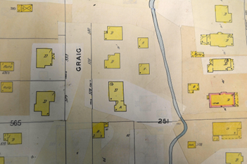
The 1948 update to the 1905 Sanborn Fire Insurance map.
On 1/2/1946, a Permit no. 961 was issued to Allen L. Reynolds to build a dwelling at 528 Craig Street, O. D. Keen was listed as contractor; the architect is unknown. Estimated cost of the house was $7,500. A second parcel was sold to the Reynolds on 10/11/1985, and a survey of the property was made that year. Allen Lynn Reynolds was born 12/29/1911 in Walla Walla and died here 7/6/1988. He and Evelyn June Hancock (1911-1989) were wed 2/16/1932 in Pasco. City Directories listed Reynolds as a teacher at Walla Walla High School; later he became Superintendent of the Walla Walla School District. Mr. and Mrs. Reynolds are buried at Mountain View Cemetery. Note that Allen L. Reynolds should not be mistaken for Allen H. Reynolds, son of Almos and Lettice (Clark) Reynolds, who was married to Fanny Kirkman, daughter of William and Isabella Kirkman.
The current house first appears on the 1948 update of the 1905 Sanborn Fire Insurance map. It is pasted over what appears to be outlines of an earlier dwelling and outbuilding on the site.
The 1948 update to the 1905 Sanborn Fire Insurance map clearly shows the original footprint of the house and its attached single garage. To the rear of the existing house, one can see the outline of an earlier building on the property that appears to have a D for dwelling on it, and a smaller outbuilding directly above the number 251.
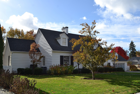
528 Craig Street is a fine example of a Cape Cod Colonial, a style dating to the early 18th century that continued in popularity through the 1950s, placing this house near the end of its run. 528 Craig had a symmetrically focused main façade as built in 1946, and a centrally placed front door displays an overhead fanlight. A single car garage on the right or west side of the house with projecting dormer was an exception to perfect symmetry. 528 Craig is a one and one-half story house with a moderately steeply pitched side gable roof that has two projecting dormers on the front. Later additions include two additional garage bays, also displaying dormers, and the one-story extension to the east side of the house.
Resources
- TitleOne Title & Escrow (formerly Pioneer Title)
- Whitman Archives
- Walla Walla city directories (various years)
- Sanborn Fire Insurance maps, 1905 edition showing 1948 updates 52
- Lyman, Prof. William D., Lyman’s History of Old Walla Walla County, Embracing Walla Walla, Columbia, Garfield and Asotin Counties, Vol. 2, S. J. Clarke Publishing Company, Chicago,1918
- Gilbert, Frank T. Historic Sketches of Walla Walla, Whitman, Columbia and Garfield Counties, Washington Territory, and Umatilla County, Oregon, A. G. Walling Printing and Lithographing House, Portland Oregon, 1882
- United States Bureau of Land Management online website
- Mountain View Cemetery burial records


