History of 355 Reser Road and the London Plane Tree – Walla Walla, WA
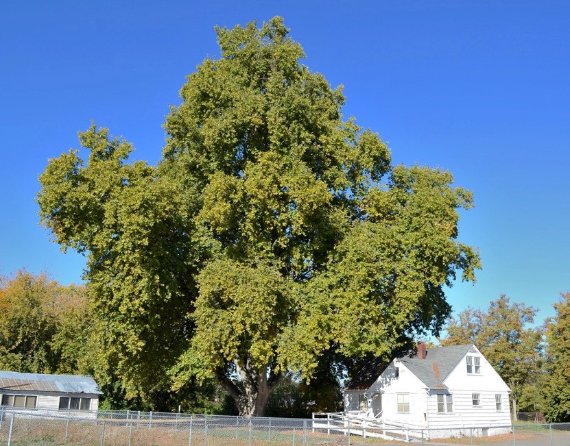
The London Plane tree at 355 Reser Road, photographed October 16, 2018.
Legal Description
33-7-36 Tax 3 less Tax 3A less portion to Walla Walla County for road right of way easement.
Full Legal Description
Beginning at a point 1,090 feet East of the Quarter Section corner on line between Sections 32 and 33 in Township 7 North, of Range 36 East of the Willamette Meridian and running thence East 554.64 feet; thence North 785.34 feet to the intersection of Yellow Hawk Creek; thence down Yellow Hawk Creek to the place of beginning… excepting therefrom, however, that part lying within the right of way of Reser Road. Situated in the County of Walla Walla, State of Washington.
Title and Occupant History
Washington Territory was created in 1853. In 1854, the new territorial legislature created Walla Walla County, which stretched from the crest of the Cascade Mountains to the crest of the Rocky Mountains in the present states of Washington, Idaho and Montana. In 1855, Isaac Stevens, governor of Washington Territory, held a council on the banks of Mill Creek at the present site of Walla Walla with representatives of regional Indian tribes to purchase land from them. The Yakamas, Cayuses and Walla Wallas were dissatisfied with the treaties and the intrusion by whites into their lands before the treaties’ ratification, and war followed. Missionaries, former French-Canadian employees of the Hudson Bay Company trading post at Wallula, and soldiers at the military Fort Walla Walla were the primary European occupants of the area prior to 1859, when the treaties were finally ratified and the land was opened for settlement. The transfer of ownership occurred by virtue of a treaty signed on June 9, 1855 in Walla Walla and ratified on March 8, 1859 by President James Buchanan, in which all of the land in the Walla Walla area was acquired from the Cayuse and Walla Walla Indian tribes.
The town of Walla Walla was originally laid out by County Surveyor Hamet Hubbard Case in 1859, prior to its formal incorporation as a city in 1862, as a one-quarter mile square with its eastern side centered on the point where Main Street crossed Mill Creek (at roughly the point where it does now). Case’s plan was filed and recorded July 5, 1867 in Book A of Plats, Page 1. The City of Walla Walla received a Trustee Town site from the U. S. Government that consisted of 80 acres, issued on July 20, 1869 by the Vancouver, W. T. District Land Office.
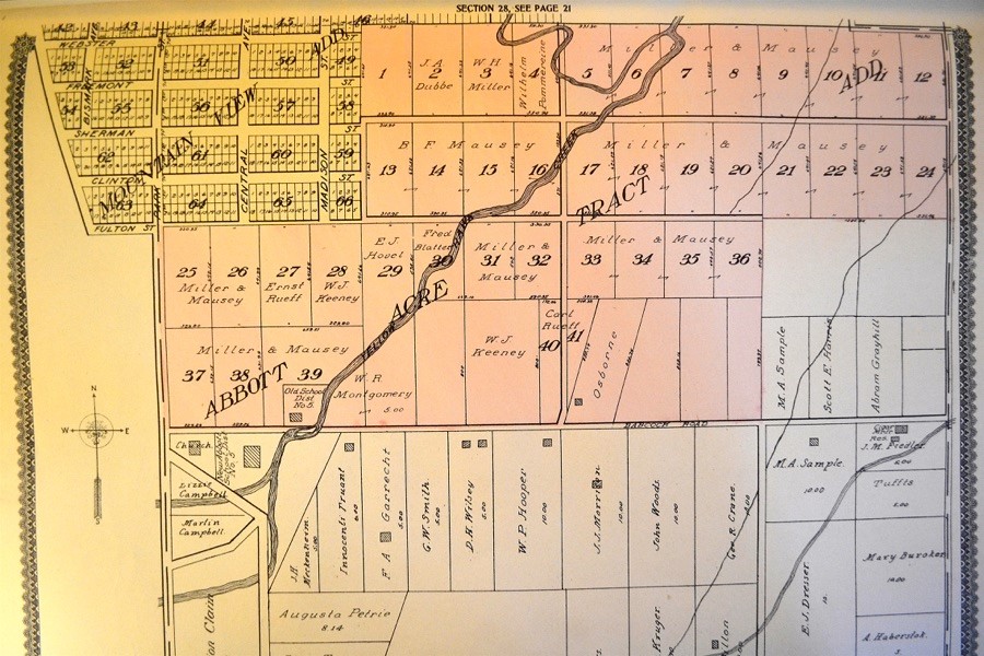
The section of Abbott Acre Tract Addition on which the London Plane tree is planted, from Standard Atlas of Walla Walla County, Washington Including a Plat Book of the Villages, Cities and Townships of the County, George A. Ogle & Co. Chicago, 1909.
Abbott Acre Tract Addition to Walla Walla City was platted for W. H. and Anna Abbott Miller and H. G. and Belle F. Mauzey, owners, and filed on 10/11/1907. Despite the fact that the additions on the south side of Reser Road were annexed by the City of Walla Walla in 2014, the property on the north side of Reser Road where Walla Walla High School is located, which includes 355 Reser Road, is still an Urban Growth Area and part of the County.
1/25/1882, Warranty Deed, John F. and Susan Abbott, grantors; D. F. Rease, grantee, “commencing at a point in the North West quarter of Section numbered 33 Township, numbered 7 North, Range numbered 36 East 1,090 feet east of the South West corner of said North West quarter and running thence East on said line 1,371 66/00th feet thence North 800 feet thence West 806 64/00th feet to the center of the channel of Yellow Hawk Creek; thence Southwesterly along the center of the channel of Yellow Hawk Creek to the place of beginning, containing 20 acres and also the right to take water from Yellow Hawk Creek on said Abbott’s land a sufficient distance above to carry it into the premises above described and in sufficient quantity for irrigating and domestic purposes and to carry on a brick yard,” $1,500.
8/29/1891, Warranty Deed, D. F. and Elizabeth V. Rease, grantors, William C. McAllister, 5 acres of the above-described parcel, $2,000.
9/13/1892, Quit Claim Deed, William C. and Margaret McAllister, grantors; J. K. Edmiston, grantee, 5 acres, $1.
11/30/1892, Warranty Deed Against Grantor, J. K. Edmiston, an unmarried man, grantor; Ralph H. Caldwell, grantee, 5 acres, “together with any water rights which I may no have in connection with this land by reason of a deed to me from Wm. C. McAllister & wife,” $1.
4/22/1893, Indenture, Ralph H. Caldwell, an unmarried man, party of the first part; Laura A. Caldwell, party of the second part, 4 acres with 4/5ths of any water rights. “This Deed is made subject to 4/5ths of the principal and interest due and to become due upon two certain Mortgages, one for $1,750 in favor of Charlotte M. Miller and one for $613.25 in favor of J. K. Edmiston…” $1.
11/14/1898, Certificate of Purchase of Real Estate, William Ellingsworth, Sheriff to Charlotte M. Miller. Charlotte M. Miller, Plaintiff vs. Ralph H. and Mary Caldwell, Laura Caldwell, W. H. Caldwell, J. K. Edmiston, and R. D. Cotton, Defendants; 5 acres sold to Plaintiff on 10/15/1898 for the highest bid of $2,707.51.
3/16/1900, Sheriff’s Deed, A. F. Kees, Sheriff to George Needles, relative to Charlotte M Miller’s transfer of above property to E. L. Houghton on 3/9/1900 and Houghton’s transfer of same to George Needles on 3/14/1900; the 5 acres were officially transferred to George Needles for $2,707.51 and filed on 3/16/1900.
1/9/1903, Warranty Deed, John A. Dubbs, a single man, grantor; Ludwig Bierwagen, grantee, 5 acres, $1.063.80.
6/5/1903, Warranty Deed, George M. and Lizzie P. Needles, grantors; John A. Dubbs, 5 acres, $1,500.
6/16/1903, Quit Claim Deed, E. L. and Susie W. Houghton, grantors; Ludwig J. Bierwagen, grantee, 5 acres, $1.
6/16/1903, Warranty Deed, Ludwig J. and Ida Bierwagen, grantors; Robert H. Johnson and John A. Rifley, grantees, 5 acres, $7,400.
7/13/1903, Quit Claim Deed, Charlotte M. and F. M. Miller, grantors; Ludwig J. Bierwagen, grantee, 5 acres, $1.
4/22/1903, Warranty Deed, John A. and Nora E. Rifley, grantors; Robert H. Johnson, grantee, 5 acres, $2,000.
1/31/1905, Warranty Deed, Robert H. and Kate Johnson, grantors; Mary A. McCool, grantee, 5 acres, $1,800.
2/26/1906, Warranty Deed, George A. McCool, a bachelor, grantor; L. T. and Sidney McCool, grantees, 5 acres more or less, $1,000.
1/16/1909, Deed, Sidney F. McCool et ux, grantor; F. A. Garrecht, grantee, 5 acres more or less.
2/11/1909, Deed, Lee V. McCool et ux, grantor; F. A. Garrecht, grantee, 5 acres.
3/5/1909, Deed, John W. McCool et ux, grantor; F. A. Garrecht, 5 acres.
3/20/1909, Indenture, F. A. and Fanny L. Garrecht, party of the first part; W. R. and Sarah Montgomery, party of the second part, 5 acres.
10/20/1911, Indenture, F. A. and Fanny Gerrecht, party of the first part; W. R. Montgomery, party of the second part, 5 acres, $1.
10/24/1911, Indenture, W. R. and Sarah Montgomery, party of the first part; H. D. May, party of the second part, 5 acres, $1.
7/22/1913, Warranty Deed, H. D. and Ruby E. May, grantors; Martha J. Highley, as her separate property free of all claim of her husband, 5 acres, $1.
5/23/1934, Quit Claim Deed, Liona Highley Castle and William C. Highley, heirs at law of Daniel K. Highley, deceased, grantors; Martha J. Highley, grantee, 5 acres, $1.
6/12/1934, Warranty Deed, Martha J. Highley, a widow and Thelma Highley Willcox, in her own separate right and estate, grantors; Emily L. Kanzler, unmarried, 5 acres, $1,200.
6/12/1934, Warranty Deed, Emily L. Kanzler, unmarried, grantor; Martha J. Highley, a widow, grantee, 5 acres, $1,200.
8/2/1934, Agreement for Deed, Martha J. Highley, a widow, grantor; W. G. Coleman, grantee, 5 acres to be conveyed by the party of the first part to the party of the second part by Warranty Deed if the party of the second part “shall first make the payments and perform the covenants hereinafter…” and pay taxes for 1933, “now a lien against said land,” $1,200.
2/20/1937, Warranty Deed, Martha J. Highley, a widow, grantor; W. G. Coleman, grantee, 5 acres, $10.
3/30/1939, Warranty Deed, W. G. and Margaret S. Coleman, grantors; Chester A. and Ida M Dicus, grantees, 5 acres more or less, $10.
5/28/1951, Certificate of Ground Water Right, State of Washington to Chester A. Dicus, regarding use of a well for domestic supply and irrigation, not to exceed 60 gallons per minute.
6/13/1963, Right of Way Easement, Chester and Ida Mae Dicus to Pacific Power & Light Company, an easement of right of way for electric transmission… including wires, towers, poles, props, guys and other supports…”this easement is for overhang only.”
1/19/1971, Statutory Warranty Deed, Chester A. and Ida M. Dicus, grantors; Walla Walla School District No. 140, a Municipal Corporation.
12/8/1977, Statutory Warranty Deed, Chester A. and Ida M. Dicus, grantors, Walla Walla School District No. 140, a Municipal Corporation, $10 and other valuable considerations.
List of Persons Residing on the 5 Acres Who could have Planted the London Plane Tree
It is the understanding of Walla Walla 2020 that the School District requested this research report to assist in trying to determine who might have planted the large London Plane tree that stands on the property adjacent to the house at 355 Reser Road. Although there is probably little or no interest in the house, for the record it appears to date from sometime between around 1930 to possibly as late as 1940. That leads to a conclusion that it was likely constructed by Martha J. Highley, who owned or had an interest in the acreage from 1913 until 1937. Since it is outside the city limits, no building permit exists.
Andy Asmus, certified arborist, measured the tree following Forest Service regulations for a record tree designation. Without referring to his notes, he recalled the height of the tree as 135 feet 27 feet of girth and 115 feet of spread. Andy did not respond to the question as to his “guesstimate” of the tree’s age, but it was reported in an article in the Union-Bulletin in August 2018 that the age is estimated to be 125 years.
Because Walla Walla city directories from the years dating to when the London Plane tree was probably planted vary significantly from year to year with regard to this property, it is difficult to determine precisely which of the owners of the property might have physically resided on the land. Because the property was and still is outside the city limits, owners were rarely listed along with Walla Walla residents; if they were, their address would have been vague, e.g., “RFD 2” or “21/2 mi s city limits,” etc. Some years the directory included a list of county residents, but many years it did not, and no information concerning specific address, occupation, etc. was ever included with names listed as county residents (although some years a county resident’s net worth was included!).
Following is a list of owners of the property who may have resided somewhere on the five acres during the years that the tree was probably planted, though not necessarily adjacent to the tree, as is the current house at 355 Reser Road. Persons with addresses possibly on the five acres with dates that suggest they could have planted the tree are in boldface Italics. Those owners whose directory addresses suggest they resided elsewhere are not in bold.
It’s also possible it was planted by someone who did not actually reside there.
1883-84 City Directory: John and Susan Abbott, res. “No. 144 2nd st;” D. F. and Elizabeth Rease, brickmaker, res. “yard 2nd st outside city.” Thus, it appears that Rease may have lived on the property, but the dates suggest that this was before the tree was planted.
1892 City Directory: neither Rease nor William and Margaret McAllister are listed. J. K. Edmiston was president of Walla Walla Savings Bank, res. “Poplar cor 1st” so he is not a candidate for the person who planted the tree.
1904 City Directory: John A. Dubbe (spelled Dubbs on the deed), laborer, res “3/4 m s city limits.” This might describe the acreage in question. Ludwig Bierwagen was only listed as a county resident, net worth $2,250. E. L. Houghton was listed as working in real estate, rentals and insurance, res “end of Alder.”
1905 City Directory: the name McCool cannot be found with city or county listings other than Mrs. Agnes McCool.
1907 City Directory: no George McCool listed, but may have been related to Sidney F. McCool, laborer, “h Mountain View add, RFD 3.” This could have been a portion of the 5 acres where the London Plane tree grows.
1910-11 City Directory: F. A. and Fanny Garrecht, “h 375 S Palouse;” no listing for John W. or Lee V. McCool could be found in either the city or county listings. W. R. Montgomery, farmer, “h ½ mile e cemetery, Mountain View add.” Thus, Mr. Montgomery could be a candidate for the person who planted the tree, although this is from a period more recent than the surmised age of the tree.
1911-12 City Directory: H. Delos May, farmer, “h 112 Merriam.”
1914 City Directory: Danl. K. and Martha Highley, farmer, “h RD 3,” net worth $440. This date, however, is probably too recent to consider.
Although subsequent listings could be included, they are all unquestionably too recent to be considered as having planted the London Plane tree.
Resources
- Pioneer/Columbia Title archived lists of deeds
- Whitman Archives
- Walla Walla City Directories, containing lists of county residents, various years
- Standard Atlas of Walla Walla County, Washington Including a Plat Book of the Villages, Cities and Townships of the County, George A. Ogle & Co. Chicago, 1909
- City of Walla Walla Development Service Department
- Andy Asmus, Walla Walla Certified Arborist


