
History of 304 Juniper Street, Walla Walla, WA

Legal Description
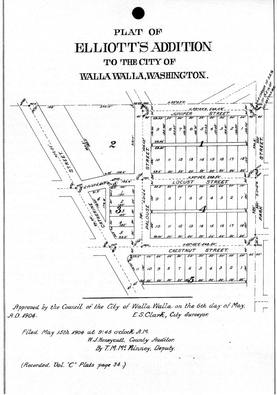
Lot 9 in Block 1 of Elliott’s Addition to the City of Walla Walla, Washington, according to the official plat thereof of record in the Office of the Auditor of Walla Walla County, Washington, in Volume C of Plats at Page 34, excepting therefrom, however, the following described tract, to-wit: Beginning at the Southwest corner of Lot 9 in Block 1 of Elliott’s Addition to the City of Walla Walla as foresaid, and running thence East along the South line of said Lot 9 a distance of 68.5 feet to the Southeast corner thereof; thence North along the East line of said Lot 9 a distance of 50 feet; thence West parallel to the South line of said Lot 9 a distance of 68.5 feet to a point in the West line of Lot 9; thence South along the West line of said Lot 9 a distance of 50 feet to the point of beginning.
Title and Occupant History
Washington Territory was created in 1853. In 1854, the new territorial legislature created Walla Walla County, which stretched from the crest of the Cascade Mountains to the crest of the Rocky Mountains in the present states of Washington, Idaho and Montana. In 1855, Isaac Stevens, governor of Washington Territory, held a council on the banks of Mill Creek at the present site of Walla Walla with representatives of regional Indian tribes to purchase land from them. The Yakamas, Cayuses and Walla Wallas were dissatisfied with the treaties and the intrusion by whites into their lands before the treaties’ ratification, and war followed. Missionaries, former French-Canadian employees of the Hudson Bay Company trading post at Wallula, and soldiers at the military Fort Walla Walla were the primary European occupants of the area prior to 1859, when the treaties were finally ratified, and the land was opened for settlement. The transfer of ownership occurred by virtue of a treaty signed on June 9, 1855, in Walla Walla and ratified on March 8, 1859, by President James Buchanan, in which all of the land in the Walla Walla area was acquired from the Cayuse and Walla Walla Indian tribes.
The town of Walla Walla was originally laid out by County Surveyor Hamet Hubbard Case in 1859, prior to its formal incorporation as a city in 1862, as a one-quarter mile square with its eastern side centered on the point where Main Street crossed Mill Creek (at roughly the point where it does now). The original plat was lost, probably in the fire of 1865. Thus, the earliest plat on file is one made by W. W. Johnson, City Surveyor, in July 1865 that claims to have made corrections to Case’s survey. Johnson’s survey was made the official plat of the City of Walla Walla on September 25, 1866, was filed and recorded July 5, 1867.
 2/29/1904, Warranty Deed, Jane Singleton, widow of John Singleton, deceased, grantor; Anna B. Elliott, grantee, beginning at the established Northeast corner of the Southeast quarter of the Northeast quarter of Section 29 in Township 7-North, of Range 36-East of the Willamette Meridian, and running thence South 0° 16” West along the East line of said Southeast quarter of the Northeast quarter 671 feet more of less, to a point in said line where the center line of Chestnut Street in Singleton’s Second Addition to the City of Walla Walla would if produced in a straight line, intersects said quarter section line; thence West along said produced center line of Chestnut Street to the point of its intersection with the Easterly line of Catherine Street in said Singleton’s Second Addition; thence Northerly along said
Easterly line of Catherine Street to the point of its intersection with the Northerly line of Locust Street in said Singleton’s Second Addition if said Northerly line of Locust Street should be produced in a straight line; thence Easterly along said produced Northerly line of Locust Street 123 and 65/100ths feet to a point; thence Northerly and parallel with the Easterly line of Catherine Street 408 and 33/100ths feet to a point on the North line of the Southeast quarter of the Northeast quarter aforesaid; thence North 89° 28” East along said North line to the point of beginning; subject, however, to the right of way of the Westerly half of Park Street of the City of Walla Walla along the Easterly line of said tract: intending to convey hereby all of that tract containing 11 and 35/100ths acres, more or less, partitioned to the said Jane Singleton by decree of the Superior Court of the State of Washington for Walla Walla County in the partition suit of Jane Singleton versus Catherine Tierney et al; and said party of the first part does hereby covenant to and with the said party of the second part, her heirs and assigns that she is the owner in fee simple of said premises; that the title to said premises is free from all incumbrances [sic] and that she will Warrant and Defend the same from all lawful claims whatsoever, $1,000.
5/14/1909, Deed, Anna B. Elliott, grantor; Gilbert P. Winans, grantee, Lot 9, Block 1…according to the recorded plat…dated April 20, 1904, with all and singular the hereditaments and appurtenances to the same…, $600. Gilbert Winans was employed at Malcolm & McLean Grocery on the southwest corner of East Main and Spokane Streets. At the time of this sale, he and his wife lived nearby on Juniper Street. Gilbert was a son of William P. and Lida Winans. William Winans arrived in Walla Walla in 1874 and with Raymond Rees formed the Rees-Winans Mercantile on the northeast corner of North 2nd and East Main. He was founder and president of the Farmers Savings Bank in the corner of the Rees-Winans Building from 1890 until his death in 1917. A lesser-known fact, perhaps, is that William Winans served briefly as unordained interim minister of First Presbyterian Church. The highly ornate Rees-Winans Building was unsympathetically remodeled in the early 1950s and continues to exist as the Jones Building.
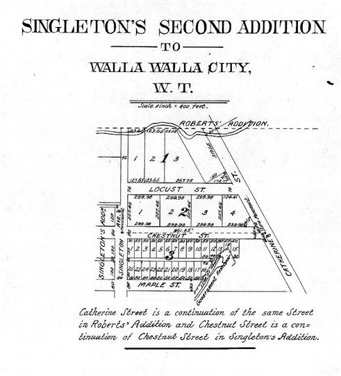
 Elliott’s Addition was formerly Singleton’s Second Addition to the City of Walla Walla, platted by John and Jane Singleton 7/7/1883, filed and recorded 7/13/1883. Singleton had been granted a patent for 160 acres in Section 29, Range 7-North, Township 36-East of the Willamette Meridian in Walla Walla County on 5/2/1870, filed in the Vancouver, W.T. land office.
Elliott’s Addition was platted by T. C. and Anna B. Elliott following the sale in 1904 of Singleton’s Second Addition by Jane Singleton, widow of John Singleton to Anna B. Elliott. It consisted of five blocks, all but Block 2 divided into 53 building lots. Elliott’s Addition runs along the west side of Park Street from Chestnut Street north to the south side of Juniper Street. It also includes 11 lots on the south side of Chestnut Street between Park and Catherine Streets. Its western line follows the east side of Catherine Street from Chestnut Street to slightly north of where Juniper Street would connect with Catherine Street if Juniper Street were extended west from its termination at South Palouse Street west to Catherine Street. The plat was approved by the City Council 5/6/1904 and filed 5/15/1904.
Thompson Coit Elliott (1862-1943) arrived in Walla Walla in 1886. He was employed in finance, operating as an investment broker at 8 South 1st Avenue. T. C. and Anna B. Elliott purchased D. W. Small’s Second Empire house on Birch Street, turned it 180° to face East Poplar Street across from Carnegie Library and greatly enlarged it. Known as the Small-Elliott House, it is on the National Register of Historic Places.
3/27/1939, Warranty Deed, Gilbert P. and Carrie Winans, his wife and who was his wife on April 20, 1904, grantors; Walter and Geneva Maxson, grantees, Lot 9, Block 1, $10
11/25/1975, Quit Claim Deed, Geneva M. Maxson, grantor as a gift to her sons; Theron B. and LaVerne Maxson, grantees, Lot 9, Block 1.
3/17/1989, Quit Claim Deed, L. LaVerne Maxson as his separate property for purposes of placing the property in trust; Marilyn Bowles as Trustee.
9/23/1989, Statutory Warranty Deed, Marilyn Bowles, Trustee and Personal Representative for the estate of Theron B. Maxson, grantor; Gerald W. and Garri A. Taylor, grantees, Lot 9, Block 1, $10 and other valuable consideration.
3/17/2022, Affidavit (Lack of Probate), Garri Ann Taylor, widow of Gerald W. Taylor, deceased, who died intestate, grantor; Robert P. Taylor, Wendy Sue Taylor, Stephen A. Taylor, Patrick R. Taylor, children Gerald and Garri Taylor, grantees, Lot 9, Block 1.
3/17/2022, Statutory Warranty Deed, Garri Ann Taylor, grantor; Christopher N. and Gwyneth L. Wold, grantees, Lot 9, Block 1, $465,000.
5/8/2023, Statutory Warranty Deed, Statutory Warranty Deed, Christopher N. and Gwyneth L. Wold, grantors; Jonathan B. and Wendy S. Braid, grantees, Lot 9, Block 1, Elliott’s Addition, $10 and other valuable consideration.
Construction of Building
Lot 1 of Block 9 in Elliott’s Addition remained undeveloped for a protracted time. The County Assessor dates the construction of 304 Juniper Street to 1939; a search of building permits at Whitman College Archives confirms the date. On 3/8/39, Walter Maxon was granted Permit 8920 to construct a house and garage on Lot 9, estimated to cost $3,500. George F. Glaspey was listed as contractor. Walter and Geneva Maxson owned the Howard Street Grocery and Gas Station at 903 Howard Street. The Walla Walla City Directory for 1939 listed them residing at 304 Juniper Street. The house remained in the Maxon family 36 years.
Stylistically, 304 Juniper Street could be classified as Modern/Traditional, not to be confused with earlier Streamline/Moderne or International style architecture. Modern/Traditional includes ranch homes, simplified Colonial style homes such as were seen on television shows such as “The Adventures of Ozzie and Harriet,” split- and tri-level homes, etc. 304 Juniper is a one and one-half story house with a multi-gable roof, that includes a prominent side gable with a lower projecting front gable extending east beyond the extremity of the house to include a round-arch passage into the side yard. A small, vented gable projects from hear the top of the main side gable, and there is even a pediment gable over the front steps. The entrance is centered, although the street façade is irregular. A sizable porch extends from the front door west and wraps around the Palouse Street side of the house. Siding is clapboard.
Resources
- TitleOne Title & Escrow (formerly Pioneer Title)
- Walla Walla County Auditor’s online property search
- Walla Walla city directories, various years
- Whitman College Archives
- Walla Walla Public Library
- Bureau of Land Management General Land Office Records


