History of 1303 Walla Walla Avenue – Walla Walla, WA
Legal Description
Green’s Annex Tax 6 Lot 3 Block 5
Full Legal Description
Beginning at the Southwest corner of Lot 3 in Block 5 of the Amended Plat of Green’s Annex to the City of Walla Walla, according to the Official Plat thereof of record in the Office of the Auditor of the County of Walla Walla, in Volume C of Plats at Page 32; and running thence North along the West line of said Lot, 88 feet; thence East at right angles 100 feet, thence South at right angles 88 feet, more or less, to the South line of said Lot; thence West along the South line, 100 feet, more or less, to THE POINT OF BEGINNING.
Title and Occupant History
Washington Territory was created in 1853. In 1854, the new territorial legislature created Walla Walla County, which stretched from the crest of the Cascade Mountains to the crest of the Rocky Mountains in the present states of Washington, Idaho and Montana. In 1855, Isaac Stevens, governor of Washington Territory, held a council on the banks of Mill Creek at the present site of Walla Walla with representatives of regional Indian tribes to purchase land from them. The Yakamas, Cayuses and Walla Wallas were dissatisfied with the treaties and the intrusion by whites into their lands before the treaties’ ratification, and war followed. Missionaries, former French-Canadian employees of the Hudson Bay Company trading post at Wallula, and soldiers at the military Fort Walla Walla were the primary European occupants of the area prior to 1859, when the treaties were finally ratified and the land was opened for settlement. The transfer of ownership occurred by virtue of a treaty signed on June 9, 1855 in Walla Walla and ratified on March 8, 1859 by President James Buchanan, in which all of the land in the Walla Walla area was acquired from the Cayuse and Walla Walla Indian tribes.
The town of Walla Walla was originally laid out by County Surveyor Hamet Hubbard Case in 1859, prior to its formal incorporation as a city in 1862, as a one-quarter mile square with its eastern side centered on the point where Main Street crossed Mill Creek (at roughly the point where it does now). The original plat was lost, probably in the fire of 1865. Thus, the earliest plat on file is one made by W. W. Johnson, City Surveyor, in July 1865 that claims to have made corrections to Case’s survey. Johnson’s survey was made the official plat of the City of Walla Walla on September 25, 1866, was filed and recorded July 5, 1867.
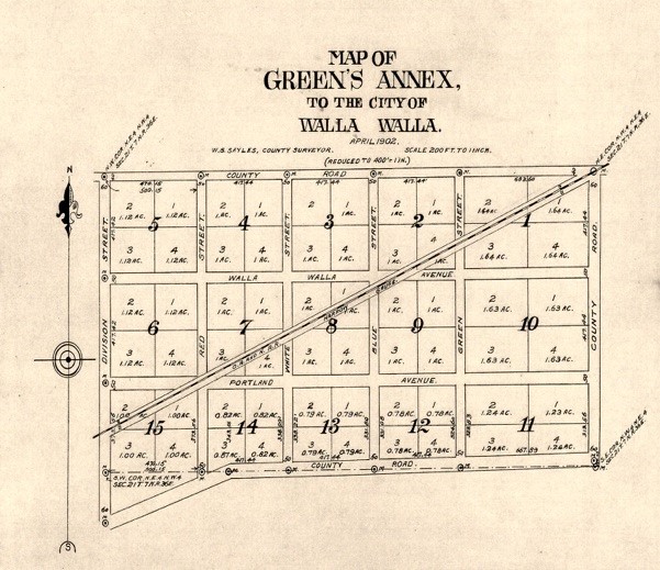
Plat Map of Green’s Annex to the City of Walla Walla. Lot 3, Block 5 is near the upper left.
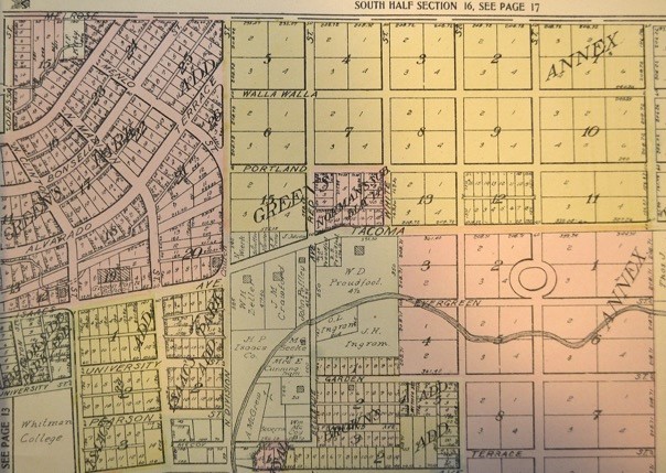
To this original area, additional parcels were annexed from time to time, usually with the name of the landowner of record at the time the additions were made. 1303 Walla Walla Avenue is in Green’s Annex, adjacent to Green’s Park Addition, named for William Orville and Mary Frances Green (Green Park School bears their name). The original parcel, Green’s Park Addition, was purchased from John Haley in 1867 and covered 19½ acres north of Isaacs Street to Melrose Avenue, which was the northern city limit, bordered on the west side by Clinton Street, and on the east by Division Street, which was the eastern city limit.
Green’s Annex to the City of Walla Walla was surveyed in October 1903 by L. W. Loehr, County Surveyor, and recorded on February 5, 1904. At that time it was bisected diagonally in a southwest-northeast direction by the Oregon Railroad & Navigation Company’s narrow gauge line that continued westerly through Green’s Park Addition via what is now Green Lane behind Green Park School; the track is no longer there. The plat map for Green’s Annex indicates that what is now North Bellevue Avenue was then known as Red Street, followed in sequence eastward by White Street and Blue Street– the Red, White & Blue streets. Following the Russian Revolution the term “Red” assumed a troublesome overtone, so Walla Walla struck the name Red Street, changing it to a more democratic sounding North Bellevue Avenue.
Green’s Annex as shown in the 1909 as illustrated in the 1909 Standard Atlas of Walla Walla County Washington (see Resources below). In both of the above illustrations Block 3 had not yet been divided into multiple building lots. As of 1909 it is apparent that only Blocks 12 and 14 had been divided.
Green’s Annex extended east to Wellington Street. Mary F. Green, a widow following the death of her husband in 1878, continued to be very active in real estate with the Green Investment Company, of which she served as president until her death in 1911. Deeds for lots sold in Green’s Park Addition contained a clause that stipulated any house erected had to have a value of at least $2,000, and be constructed within a specified time, in order to discourage land speculators. No such requirements could be found pertaining to lots in Green’s Annex.
Although Lot 3 of Block 5, as noted under Full Legal Description, consists of 100 feet eastward from its west border on North Division Street it was subdivided into two sections: the west 50 feet and the east 50 feet, each of which was sold singly at times. When so done this will be noted.
On 5/10/1870, the Vancouver, W. T. Land Office granted a serial patent for 40 acres of land in Section 21, Township 7 North, Range 36 East of the Willamette Meridian to William O. Green, husband of Mary F. Green.
1/5/1907, Warranty Deed, Mary F. Green, a widow, grantor; Benjamin N. Bessett, grantee, Lot 3, Block 5 “containing 12/100ths acres more or less,” $275. Bessett was a partner in Nagel & Bessett dba Olympic Shoeing Company, 35-37 South Palouse Street. The 1905 city directory listed his residence as 525 East Alder Street. The 1906 directory recorded his residence as “Walla Walla Av cor Division, Green’s Annex,” that either describes the location of the current house at 1303 Walla Walla Avenue or a house on Lot 2, Block 6 on the other corner of Division and Walla Walla Avenue. The transaction between Mary Green and Benjamin Bessett appears not to have been filed until January 1907.
1/5/1907, Warranty Deed, B. N. and Harriett Smith Bessett, grantors; Harry H. Showerman, grantee, listing $10 nominal consideration. Harry Showerman was a reporter for the Bulletin Publishing Company, later the proprietor of Shady Nook Dairy, with various residences in city directories during the years surrounding 1907, but not including Walla Walla Avenue and North Division Street.
8/8/1907, Warranty Deed, Harry H. and Grace D. Showerman, grantors; T. F. Kendall, grantee, $12,000. The huge price increase between January and August reflects considerable other properties being part of this sale. In fact, Kendall apparently did not reside in the house on the corner of Walla Walla and Division, and was no longer included in city directories by 1910.
9/5/1907, Warranty Deed, T. F. and Alice M. Kendall, grantors; J. W. Wolfe, grantee, $1. This sale included only Lot 3, Block 5. J. W. Wolfe was a partner in Wolfe, Valaer & Brooke, Real Estate, Loans & Exchanges, with office in the Paine Building. Wolfe resided at 405 North 7th.
1/21/1908, John W. and Minnie M. Wolfe, grantors; Jennie C. Brooke, grantee, $10 and other valuable considerations.
8/14/1909, Indenture, Jennie C. and Walter B. Brooke, grantors; J. D. McPherson, grantee, $10 and other valuable considerations. This transaction included only the west 50 feet of Lot 3. As can be seen, Jennie Brooke was the wife of Walter Brooke, also a partner in Wolfe, Valaer & Brooke, with residence in Garden City Heights Addition.
11/7/1910, Indenture, Walter B. and Jennie C. Brooke, grantors; William A. Welles, Jr., grantee, $10 and other valuable considerations. This transaction included only the east 50 feet of Lot 3. Welles was involved in real estate, with residence at 448 Chase Avenue.
1/30/1911, Indenture, William A. and Martha J. Welles, grantors; F. A. Youmans, a married man, grantee, $10. This transaction included only the east 50 feet of Lot 3.
12/14/1911, Warranty Deed, F. A. and A. J. Youmans, grantors; J. E. Ransom, grantee, $1. This transaction also included only the east 50 feet of Lot 3, but also included 10 acres in Section 25, Township 7 North, Range 35 East of the Willamette Meridian for the price of $7,500.
Names of non-owners were listed as living at this address during the preceding five years and it is assumed that 1303 Walla Walla Avenue was occupied by renters.
11/11/12, Indenture, F. B. and Jennie Clark, grantors; Chester G. Johnson, grantor, $1. This transaction included only the west 50 feet of Lot 3. Jennie Clark formerly was the wife of Walter B. Brooke. Clark was president of Clark-Kirkman Company with residence at 120 East Birch Street. Chester Johnson was found in a 1914 city directory to be residing at 1303 Walla Walla Avenue on the west 50 feet of Lot 3.
5/9/1914, Quit Claim Deed, Harry H. and Grace D. Showerman, grantors; T. F. Kendall, grantee, $1.
6/1/1914, Indenture, F. B. and Jennie B. Clark, grantors; Chester G. Johnson, grantor, $1. This transaction also included only the west 50 feet of Lot 3.
4/25/1918, Indenture, Chester G. and Cora B. Johnson, grantors; J. K. Rierdan, grantee, $1. This transaction included only the west 50 feet of Lot 3.
10/30/1919, Warranty Deed, J. K. and Louise Riorden (spelling as listed on deed), grantors; Claude and Fannie Mayo, grantees, $2,350. This transaction included only the west 50 feet of Lot 3. Claude Mayo was a rural mail carrier. In the 1918 city directory the Mayos lives at 1740 Isaacs; there was no directory published in 1919, but in 1920 the Mayos were listed at an address of 1303 Walla Walla Avenue on the west 50 feet of Lot 3.
11/11/1921, Quit Claim Deed, Benjamin N. and Harriet Smith Bessett of Columbia County, grantors; Harry H. Showerman, grantee, all of Lot 3, $1.
4/30/1931, Lis Pendens, City of Walla Walla, a Municipal Corporation vs. Plaintiffs Walter B. and Jennie C. Brooke and hundreds of other plaintiffs.
4/30/1931, Treasurer’s Tax Deed, Ren Thompson, Walla Walla Treasurer, “to foreclose tax liens…and order of sale…” of hundreds of parcels including “Tax #2, Lot 3, Block 5 of Green’s Annex.”
6/5/1940, Quit Claim Deed, City of Walla Walla, a Municipal Corporation, grantor; H. Claude Mayo (whose wife is Fannie R. Mayo), $300. This transaction cleared the east 50 feet of Lot 3 to the Mayos, and confirmed the entire 100 feet along Walla Walla Avenue as a single parcel.
10/17/1964, Quit Claim Deed, Claude Mayo, grantor; Ed C. and Bertha Bachthold, grantees, $10 and other valuable considerations. Bertha Bachthold was the wife of Edward C. Bachthold, a farmer who was also involved in timber.
10/17/1964, Quit Claim Deed, Hazelle B. Richards (daughter of Claude and Fannie Mayo), grantor; Ed C. and Bertha Bachthold, grantees, $10 and other valuable considerations.
10/17/1964, Quit Claim Deed, Marvin C. Mayo (son of Claude and Fannie Mayo), grantor; Ed C. and Bertha Bachthold, grantees, $10 and other valuable considerations.
10/17/1964, Affidavit, Marvin C. Mayo to The Public, as the son of H. Claude Mayo and Francis Mayo, deceased, declaring her estate to be free of any debts.
10/20/1964, Quit Claim Deed, Helen C. Anderson (daughter of A. Claude and Fannie Mayo), grantor; Ed C. and Bertha Bachthold, grantees, $10 and other valuable considerations.
10/24/1964, Quit Claim Deed, Frances S. Harter (daughter of Claude and Fannie Mayo), grantor; Ed C. and Bertha Bachthold, grantees, $10 and other valuable considerations.
7/26/1971, Statutory Warranty Deed, Ed C. and Bertha V. Bachthold, grantors; Eastgate Missionary Baptist Church, grantee, $12,500. The house was purchased as the parish house for the minister of the church, who resided there until 1989. The church is located at 1737 Portland Avenue.
8/31/1989, Statutory Warranty Deed, Paul Nixon, U. S. Sterlin, Gene Jenkins, David Spurlock and Leo Freouf, Trustees for Eastgate Missionary Baptist Church, grantors; Mark S. Hoke, a single person, $39,000.
9/22/1999, Statutory Warranty Deed, Mark S. and Jan O. Hoke, grantors; Jackie S. Wood, grantee.
Construction of Building
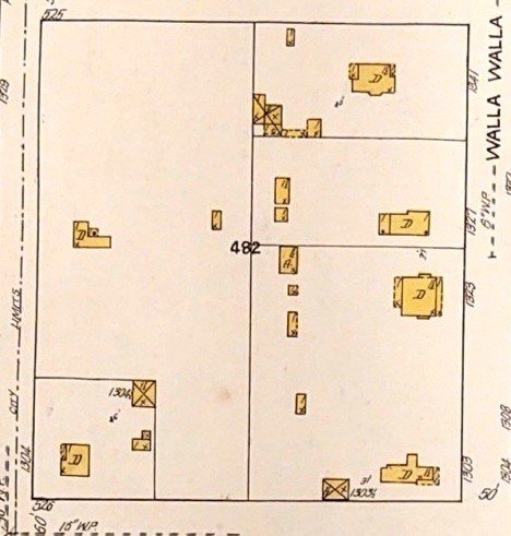
Sanborn Fire Map, 1905, with 1923 updates. 1303 Walla Walla Avenue can be seen at the bottom right corner. Walla Walla Avenue is on the right, Melrose Avenue on the left, North Division Street across the bottom. Notice how different the footprint of the dwelling appears from the footprint of the house that exists today. The primary east/west gable on the north side of the house does not appear, and what is quite apparently a much more recent smaller east/west gable is also missing.
Although it is for certain that there was a house on the northwest corner of Walla Walla Avenue and North Division Street as early as 1906, it is not possible to determine with certainty if the house at 1303 Walla Walla Avenue incorporates portions of the 1906 house, or whether that earlier structure was razed or otherwise destroyed. The property was too far out of the city to be included in the 1905 Sanborn Fire Map. The first revisions to the 1905 Sanborn map were not made until 1923, by which time the current house is evident on the west half of Lot 3, although showing a somewhat different footprint than it now does.
The County Assessor lists several listed build dates for 1303 Walla Walla Avenue. The online Walla Walla County Property Search lists the date of construction as 1935, and the exterior appearance of the house suggests it might well have been built at that time. On 10/30/1919, the west one-half of Lot 3 was purchased by H. Claude and Fannie Mayo. A search of Walla Walla city directories disclosed that the Mayos resided there by 1920 (see Warranty Deed of 10/30/1919 on Page 5). During 2020, all hard copy Walla Walla County Assessment records were digitized and currently are archived in Olympia; however, they may be seen online and the assessment for 1303 Walla Walla Avenue lists 1920 as its date of construction.
City of Walla Walla building permits are only preserved as far back as September 1907. Dana Bronson, Associate Archivist with Northwest and Whitman Archives, graciously agreed to search through City of Walla Walla building permits from 1919 to 1921 and the years surrounding 1935. Following two searches, she reported that no building permit could be found between 1919 and 1921. At that time, Division Street was the east boundary of Walla Walla; that being so, 1303 Walla Walla Avenue on the east side of North Division Street technically was outside the city limits. (Efforts to determine when the east boundary was moved beyond Division Street were inconclusive. An undated GIF [Geographic Information Systems] map shows School Avenue as the farthest east north/west street. Clinton Court Apartments, built in 1922, is shown on this map indicating that the date of the map is more recent than that year. The map does not include the Marcus Whitman Hotel, although someone “smudged” in a notation of it at 2nd and Rose. Thus, it can be ventured that the east city limit was moved beyond Division sometime after 1922, but prior to 1928.
The Archivist located Permit 6977, issued to H. C. Mayo (Claude Mayo) on 9/13/1935, to “re-roof” 1303 Walla Walla Avenue, for which Mr. Mayo was listed as contractor. Estimated cost of the new roof was $100, and cost of the permit 50 cents. There was no mention of remodeling the exterior of the house, but this could explain the Walla Walla County Property Search build date of 1935 and the obvious discrepancy in the 1923 and 2021 footprints of the house. Since the Mayos purchased the property fairly late in 1919, a build date of 1920 is most logical. Lacking a building permit issued to the Mayos to either remodel the house, or raze the original house and construct anew, this discrepancy remains unresolved at this time. It is obvious, though, that the smaller gabled pentatonic addition that extends east of the main gable and opens onto a large deck on the south side is a recent addition and dates to the ownership of Mark Hoke during the 1990s.
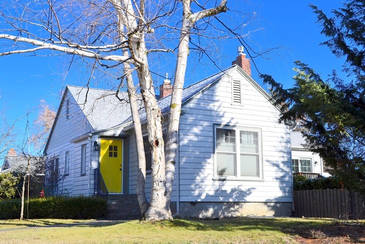
However 1303 Walla Walla Avenue may have appeared upon completion in 1920 – and this cannot be determined from existing records – its current appearance could be described as a one and one-half story cross gabled New England or Cape Cod Colonial Revival style with clapboard siding. The primary gable on the left extends fore and aft with a slightly lower secondary side gable that extends to the right. The entrance is at the west intersection of these two parts of the house, extending slightly from the Division Street exposure, but with the front door facing Walla Walla Avenue. The gabled roof is moderately pitched with no projecting eaves. The house presents a very appealing street appearance.
As to a build date, it appears the original structure was built circa 1906 by Benjamin Bessett, and remodeled or rebuilt circa 1919, with a further addition in the 1990s.
A note about Frances (Fannie) Mayo (1887-1963) is worth noting. She was a daughter of one of a number of Raders who settled in Walla Walla, Daniel O. and Barbara S. Rader. Daniel had fought on the Union side in the Civil War and was a farmer. Fannie married Harry Claudius (Claude) Mayo (1885-1969). Unquestionably, the most famous – or infamous – member of the extended Rader family in was the late University of Washington philosophy professor Melvin Rader, the son of Walla Walla attorney and farmer Cary Melvin Rader. On 3/8/1947, as Communist hysteria was growing throughout the country, the Washington State Legislature established the Joint Legislative Fact-Finding Committee on Un-American Activities, Washington State’s version of the Federal House on Un-American Activities Committee (HUAC). Several professors at the UW were accused by Rep. Albert Canwell of Spokane of being Communists. Prof. Rader fought back against the charge and eventually was cleared, although several professors were terminated. (The history of this period can be read in Prof. Rader’s book, False Witness [University of Washington Press, 1969].) The home of Prof. Rader’s brother, Ralph Rader, and was also raided at this time by members of the Canwell Committee. One wonders if the house at 1303 Walla Walla Avenue, with its nebulous connection to Prof. Rader, might also have been searched.
Resources
- TitleOne (formerly Pioneer Title)
- Walla Walla County Auditor’s Vault Indexes of recorded deeds
- Walla Walla County Assessor
- Whitman Archives, and in particular Dana Bronson, Associate Archivist, for online assistance, as Archives remains closed to the public during the pandemic.
- Walla Walla City Directories, various years
- Kammy Hill, Walla Walla City Clerk
- Jon Maland, Senior Planner, City of Walla Walla Development Services Department
- Standard Atlas of Walla Walla County Washington Including a Plat Book of the Villages Cities and Townships of the County, George A. Ogle & Co., Chicago, 1909
- US Department of the Interior, Bureau of Land Management, General Land Office Records Sanborn Fire Maps, 1905 edition with 1923 updates
- City of Walla Walla Development Services – Permits
- Descendants of William Rader on bmi.net
- www.findagrave.com


