History of 1235 East Isaacs Avenue – Walla Walla, WA

Legal Description
Green’s Park Addition to the City of Walla Walla, Lot 5, Block 20; plus partial alley vacation; less public road easement.
Title and Occupant History
Washington Territory was created in 1853. In 1854, the new territorial legislature created Walla Walla County, which stretched from the crest of the Cascade Mountains to the crest of the Rocky Mountains in the present states of Washington, Idaho and Montana. In 1855, Isaac Stevens, governor of Washington Territory, held a council on the banks of Mill Creek at the present site of Walla Walla with representatives of regional Indian tribes to purchase land from them. The Yakamas, Cayuses and Walla Wallas were dissatisfied with the treaties and the intrusion by whites into their lands before the treaties’ ratification, and war followed. Missionaries, former French-Canadian employees of the Hudson Bay Company trading post at Wallula, and soldiers at the military Fort Walla Walla were the primary European occupants of the area prior to 1859, when the treaties were finally ratified and the land was opened for settlement. The transfer of ownership occurred by virtue of a treaty signed on June 9, 1855 in Walla Walla and ratified on March 8, 1859 by President James Buchanan, in which all of the land in the Walla Walla area was acquired from the Cayuse and Walla Walla Indian tribes.
The town of Walla Walla was originally laid out by County Surveyor Hamet Hubbard Case in 1859, prior to its formal incorporation as a city in 1862, as a one-quarter mile square with its eastern side centered on the point where Main Street crossed Mill Creek (at roughly the point where it does now). Case’s plan was filed and recorded July 5, 1867 in Book A of Plats, Page 1. The City of Walla Walla received a Trustee Town site from the U. S. Government that consisted of 80 acres, issued on July 20, 1869 by the Vancouver, W. T. District Land Office.
Mary Frances Green platted Green’s Park Addition in July 1903, it was approved by the City Council July 21, by the County Council July 22nd, and filed July 23. The addition was in what was then the northeast outskirts of town in a swampy area rented to garden farmers, among them members of the Chinese community. Mary Green had purchased the land with her late husband, William Orville Green from John Haley on October 7, 1867, which was part of Haley’s United States Government patent claim of July 15, 1865. The Greens were early settlers of Walla Walla, coming to the town in 1862 during the gold rush period.
William O. Green was an associate of Dr. Dorsey Singh Baker in the stock business and acquired considerable land in Walla Walla and Franklin Counties. Green died in 1878, leaving his widow to manage their land, businesses and property.
The land that would become Green’s Park Addition was deeded to the Green children who, on December 30, 1895, quitclaimed the property back to Mary F. Green for one dollar. In an effort to control the type of buildings that were erected, the Green family initially stipulated that a single family dwelling house had to be built on the land for a specific cost, usually at least $2,000, in part to discourage land speculators.
Mary F. Green transferred all of her property to the Green Investment Company in 1909, and remained president of the business until her death on November 9, 1911.
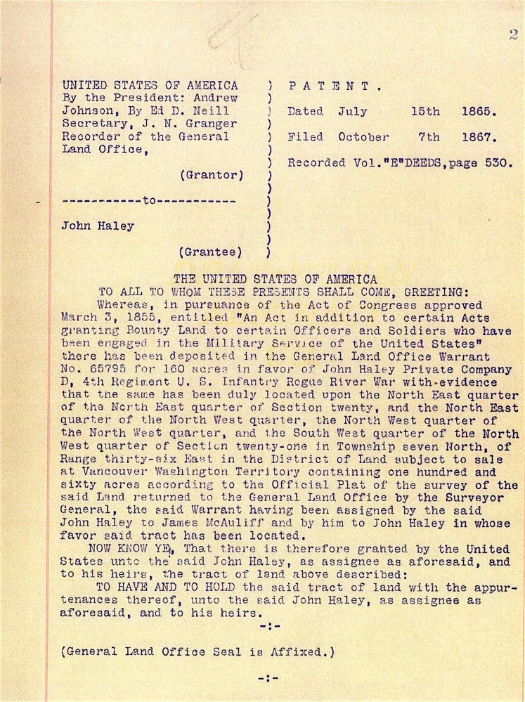
Patent of 10/7/1867 issued to John Haley through the Vancouver, W.T. District Land Office.
10/7/1867, Patent, United States of America, Andrew Johnson, President, grantor; John Haley, grantee, 160 acres (see Addendum). This patent was presumably issued through the Vancouver, W.T. District Land Office. Little information could be located about John Haley (sometimes spelled Hailey) although he was briefly in 1881 co-owner/publisher of the East Oregonian newspaper in Pendleton.
10/8/1867, Warranty Deed against grantor, John Haley, grantor; William O Green, grantee, “…the North East quarter of the North East quarter of Sec. twenty… and also all that parcel of land of the South East quarter of the North East quarter of Section number twenty… containing 19 55/100 acres more or less… “ $1,500.
1/6/1896, Quit Claim Deed, Clarinda J. and Hugh Roland Smith, Anna B. and W. H. Barnett, Philinda Green, Mary O. Green, as children and heirs of the late William O. Green and Mary F. Green, grantors; Mary F. Green, a widow, grantee, the parcel as described in the warranty deed above plus 320 acres and 2 lots at the corner of Alder and 1st Streets, $1.
12/23/1902, Affidavit, H. C. Baer to The Public, to establish that he was well acquainted with the late William O. Green, grantee of the warranty deed of 10/7/1867 [filed 10/8/1867], that William O. Green died in 1878, that he, Baker, is well acquainted with the four daughters of William O. and Mary F. Green, and that Mary F. Green is the widow of William O Green.
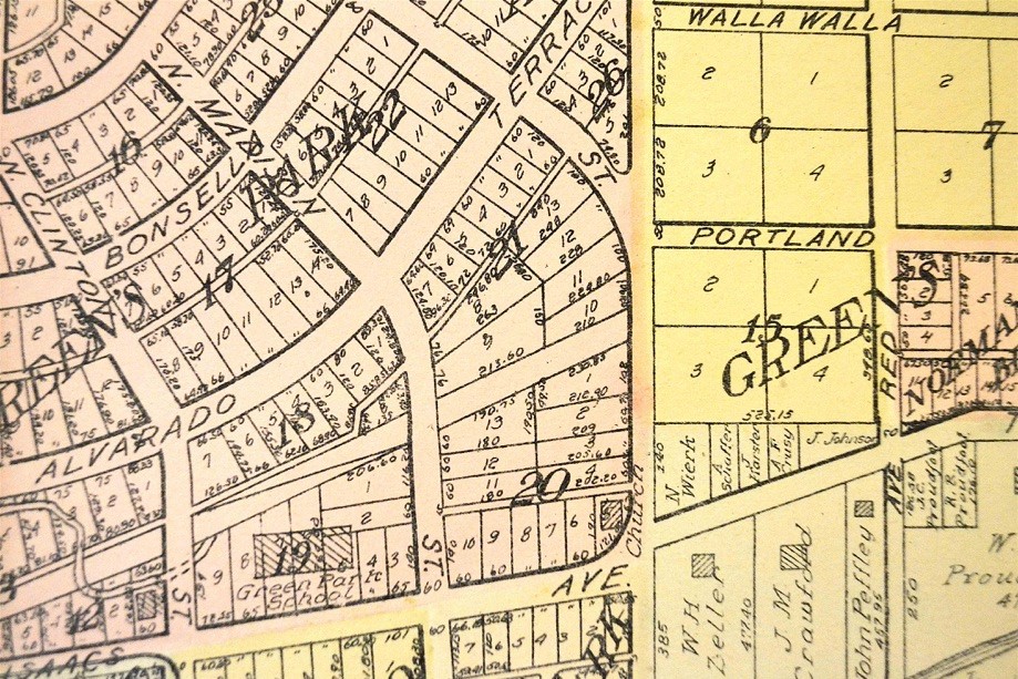
Olivet Congregational Church may be seen at the northwest corner of Isaacs Avenue and Division Street on this map from a 1909 atlas of Walla Walla County.
2/7/1907, Warranty Deed, Mary F. Green, a widow, grantor; The First Congregational Church of Walla Walla, a corporation, grantee. Lot 5, Block 20 of Green’s Addition, $1. This is the first transaction dealing exclusively with Lot 5, Block 20. First Congregational Church’s second church building was located on the south side of Rose Street near the corner of North 2nd Street. That building was vacated in January 1900 when the congregation moved to its new third building on the corner of Palouse and Alder Streets. The old building was rented for a time to the Christian Science Church. It was moved from 2nd and Rose Streets to the northwest corner of Isaacs Avenue and Division Street in 1906, where it was incorporated as Olivet Congregational Church on 12/28/1906. It was reported that most of its congregation consisted of Whitman faculty and students. Indeed, on 6/8/1912 the Walla Walla Union reported that services would cease entirely during the summer break. Eventually, “transportation advances made the church unnecessary,” and members united with First Congregational Church. The “site and the building were sold” in 1914 [sic – see following warranty deed], according to a 1964 First Congregational Church centennial history booklet.
6/1/1916, Warranty Deed, The First Congregational Church of Walla Walla, a corporation, grantor; C. H. Crawford, grantee, $1 and other valuable considerations. Clarence Howard Crawford (1892-1979), who used his middle name commonly, was a son of John M. and Martha C. Crawford of Whitehouse-Crawford Planing Mill & Furniture Company. Members of the Crawford family owned both houses diagonally across the intersection of Isaacs and Division, and prior to his marriage C. Howard Crawford resided in the family home at 1324 Isaacs Avenue, the larger and westerly of the two Crawford homes that to this day remain in the family. In the 1914 and 1915 city directories he was listed as assistant to the general manager of Whitehouse-Crawford. He was later a bookkeeper for Tum-A-Lum Lumber Company. Howard Crawford married Margaret Roup c. 1915-16.
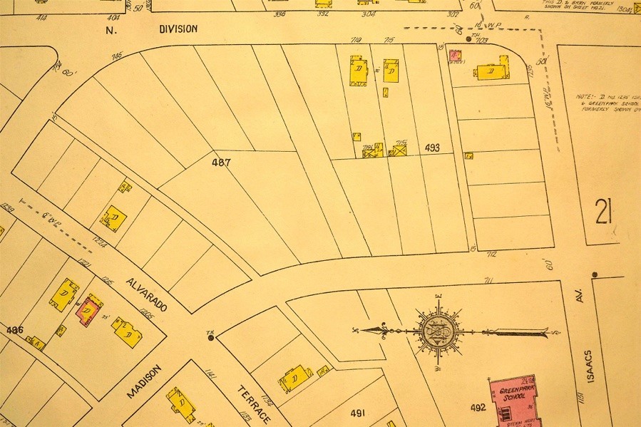
1235 Isaacs Avenue is seen at the upper right corner of this page that comprised an “Additional Index” inserted in 1923 to the 1905 Sanborn Fire Map. The porte cochère and full width front porch are obvious
9/22/1922, Quit Claim Deed, The First Congregational Church of Walla Walla, Washington, grantor: G. W. C. Reynolds, grantee, to clear title to Lot 5, Block 20, as purchased by grantee from C. H. Crawford.
9/22/1922, Warranty Deed, C. H. and Margaret R. Crawford, grantors; G. W. C. Reynolds, grantee, $10. George Reynolds owned Poultry Shipping Company.
1/21/1935, Quit Claim Deed, Mamie A. Reynolds, widow of George W. C. Reynolds, deceased, grantor; Mabel Brents Robb, whose husband is John R. Robb, grantee, $1. John Robb was a teller at Baker-Boyer Bank. The Robbs did not reside at 1235 Isaacs, using it for rental income.
12/15/1937, Quit Claim Deed, Jasper A. Reynolds, grantor; Mabel Brents Robb, whose husband is John R. Robb, grantee, $10.
11/15/1944, Warranty Deed, John R. and Mabel Brents Robb, grantors; Harry M. and Pansy B. Reiff, grantees, $3,633. Harry Reiff was a supervisor at Interior Grocery Company.
12/17/1949, Warranty Deed, Harry M. and Pansy R. Reiff, grantors; Sherwood & Roberts, Inc., grantee, $10.
3/14/1950, Warranty Deed against grantor, Sherwood & Roberts, Inc., grantor; Charles and Mary E. Tramel, grantees, $10. Mr. Tramel was a clerk for Northern Pacific Railway.
2/15/1951, Warranty Deed, Charles and Mary E. Tramel, grantors; Ferdie D. and Mildred L. Nessel, $10. Mr. Nessel was manager of Midstate Amusement Company.
5/29/1969, Quit Claim Deed, Ferdie D. and Mildred L. Nessel to The City of Walla Walla, a municipal corporation, for street purposes, “beginning at the southwesterly corner of Lot 5, Block 20… thence northwesterly… a distance of 3.89 feet; thence northeasterly a distance of 39.83 feet, to the southeasterly line of… Lot 5, thence southwesterly… 42.79 feet to the point of beginning,” $1 and other valuable considerations.
11/28/1977, Statutory Warranty Deed, Ferdie D. and Mildred L. Nessel, grantors; Jonathan H. and Melissa J. Webster, grantees, $10 and other valuable considerations.
9/3/1991, Easement, Jonathan H. and Melissa J. Webster, grantors; US West Communications, Inc., a Colorado corporation, a 5’ x 10’ private easement for 2700 PR interface, $200.
1994 (undated as to month and day), Ordinance vacating “all of that remaining portion of the 15-foot wide alley extending between North Division Street and Portland Avenue in Block 20 of Green’s Park Addition not vacated previously…” Prior to any expansion of the Green Park School property eastward, a 15-foot wide alley existed parallel to Isaacs directly behind 1235 Isaacs between Division and Madison Streets.
In 1990, the Walla Walla School District attempted to acquire all of the existing houses along Isaacs and Portland Avenues and North Division Street in order to expand the Green Park school ground. Madison Street was terminated at Green Lane, no longer extending clear through to Isaacs Avenue. What remained of the alley was reconfigured, making a 90° arc to the north, exiting on Portland Avenue.
Construction of Building
On 12/28/1916, C. Howard Crawford paid $3 for Building Permit 2324 to construct a dwelling on the northwest corner of Isaacs and Bellevue Avenues, estimated to cost $2,900. Noted Walla Walla contractor, J. A. McLean, whose impressive home is at 1049 Alvarado Terrace, was listed as contractor for the job. There is speculation that the lot and house were, or perhaps the lot only was, a wedding gift from the senior Crawfords to their newly-married son and daughter-in-law.
The first evidence of the house on a Sanborn Fire Map is on a page of the 1923 Additional Index at the back of the 1905 edition that includes Bellevue Avenue that, in 1905, was beyond the east city limit of Division Street. The 1916-17 city directory lists C. Howard Crawford still residing in the family home at 1324 Isaacs Avenue. The 1918 directory (copyright January 1918) discloses that C. Howard and Margaret Crawford were both residing at 1324 Isaacs Avenue. Howard Crawford’s net worth at the time was only $400; perhaps he had spent heavily in constructing his house during 1917. There was no city directory published in 1919, and the first documentation of the Crawfords residing at 1235 Isaacs is their listing at that address in the city directory for 1920. However, due to the building permit having been issued at the end of 1916, it is highly probable that the house was constructed in 1917.
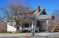
1235 East Isaacs is a one and one-half story craftsman bungalow, whose exterior retains much of its original appearance. It has a gable roof with shed gables at the front and back. Siding of the main floor is clapboards, with shingles covering the exterior of the second floor. While the contractor is established, the architect is unknown, but it is worth speculating that plans may have been prepared by the engineering department of Whitehouse-Crawford. The 1923 Additional Index to the 1905 Sanborn Fire Map gives evidence of a full-width front porch. The east portion of this porch was removed at some point and the west portion was enclosed, with concrete steps leading to an entrance room. The original round supporting columns of the porch and of the attached porte-cochère are intact.
When the current owners purchased the house in 1977, the upstairs was essentially unfinished. During World War II, the military leased this space to house soldiers stationed at the Walla Walla. Army Air Base. As a consequence, there was some rudimentary division of spaces for sleeping and a bathroom, with minimal knob and tube wiring. After living for a couple of years on the first floor of the house, the current owners, with two young children at the time, finished the space, which added three bedrooms and a full bath.
As mentioned, the Walla Walla School Board, in an enlargement of Green Park School and expansion of the school ground, in 1990 attempted to purchase all existing houses along Isaacs and Portland Avenues and North Division Street. The current owners of 1235 East Isaacs and the owners of the house on the southeast corner of Portland Avenue and Madison Street (the Doyles who own Doyle Electric) declined to sell. These are the only two houses that remain of a collection of former houses that were either demolished, or in a few cases moved elsewhere.
Resources
- Pioneer/Columbia Title
- Whitman Archives
- City Directories, various years
- Gilbert, Frank T., Historic Sketches of Walla Walla, Whitman, Columbia and Garfield Co’s, W.T. also Umatilla Co. Or., Portland, Oregon, 1882
- Sanborn Fire Maps (1905 first edition; 1923 Additional Index to 1905 edition, including portions of Walla Walla east of the former city limit of Division Street)
- Standard Atlas of Walla Walla County Washington Including a Plat Book of the Various Cities, Villages and Townships, George A. Ogle & Co., Chicago, 1909
- Mountain View Cemetery records
- U.S. Census records, 1910 and 1920
- Up-To-The-Times, December 1916
- Walla Walla Union, various
- A Brief History of the First Congregational Church, UCC, 1964


