History of 1007 Bonnie Brae Street – Walla Walla, WA
Legal Description
Lot 16 in Block 2 of Green’s First Addition to the City of Walla Walla, Washington, according to the official plat thereof of records in the Office of the Auditor of Walla Walla County, Washington, in Book C of Plats at Page 21.
Title and Occupant History
Washington Territory was created in 1853. In 1854, the new territorial legislature created Walla Walla County, which stretched from the crest of the Cascade Mountains to the crest of the Rocky Mountains in the present states of Washington, Idaho and Montana. In 1855, Isaac Stevens, governor of Washington Territory, held a council on the banks of Mill Creek at the present site of Walla Walla with representatives of regional Indian tribes to purchase land from them. The Yakamas, Cayuses and Walla Wallas were dissatisfied with the treaties and the intrusion by whites into their lands before the treaties’ ratification, and war followed. Missionaries, former French-Canadian employees of the Hudson Bay Company trading post at Wallula, and soldiers at the military Fort Walla Walla were the primary European occupants of the area prior to 1859, when the treaties were finally ratified and the land was opened for settlement. The transfer of ownership occurred by virtue of a treaty signed on June 9, 1855 in Walla Walla and ratified on March 8, 1859 by President James Buchanan, in which all of the land in the Walla Walla area was acquired from the Cayuse and Walla Walla Indian tribes.
The town of Walla Walla was originally laid out by County Surveyor Hamet Hubbard Case in 1859, prior to its formal incorporation as a city in 1862, as a one-quarter mile square with its eastern side centered on the point where Main Street crossed Mill Creek (at roughly the point where it does now). The original plat was lost, probably in the fire of 1865. Thus, the earliest plat on file is one made by W. W. Johnson, City Surveyor, in July 1865 that claims to have made corrections to Case’s survey. Johnson’s survey was made the official plat of the City of Walla Walla on September 25, 1866, was filed and recorded July 5, 1867.
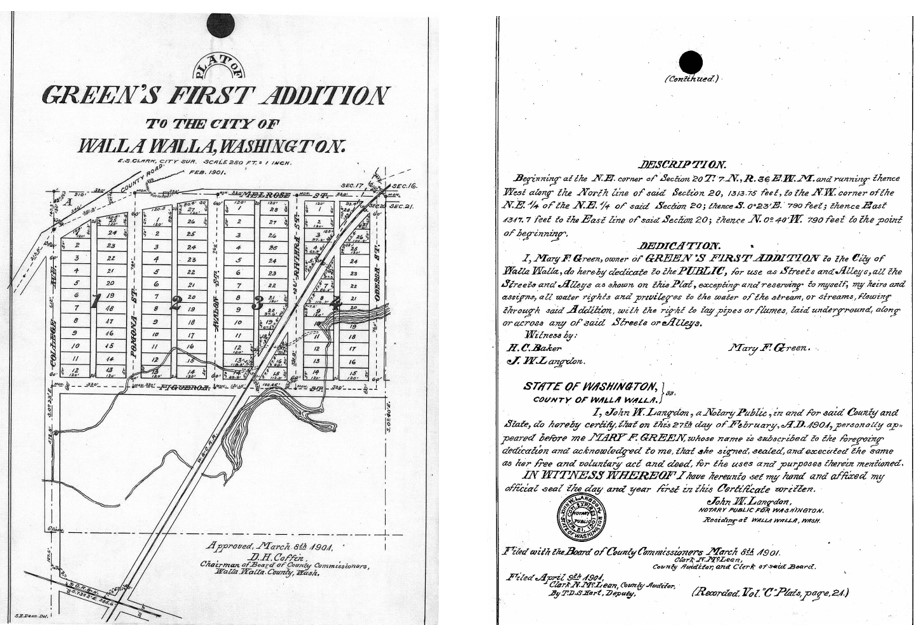
The 1901 Plat Map of Green’s First Addition
To this original area, additional parcels were annexed from time to time, usually with the name of the land owner of record at the time the additions were made. William O. Green was an associate of Dr. Dorsey Singh Baker in the stock business and acquired considerable land in Walla Walla and Franklin Counties. Green died in 1878, leaving his widow to manage their land, businesses and property. His widow, Mary Frances Green, platted Green’s First Addition in February 1901, it was certified February 27, 1901, and filed March 8, 1901. It contained 86 building lots. The addition was in what was then the northeast outskirts of town in a swampy area rented to garden farmers, among them members of the Chinese community. Mary Green had purchased the land with her late husband, William Orville Green from John Haley on October 7, 1867, which was part of United States Government patent claim issued to John Haley. The Greens were early settlers of Walla Walla, coming to the town in 1862 during the gold rush period. On the plat map of Green’s first Addition the western part of the much larger Green’s Park Addition, seen below the broken horizontal line, is blank. It was not platted by Mary Green until 1903, filed on July 3rd of that year.
Bonnie Brae Street did not exist until Green’s Park Addition was platted, when Bonnie Brae was laid out in serpentine fashion from Alvarado Terrace just east of Penrose Avenue on the map to Figueroa Street, where it terminated just west of Avalon Street. The first update to the 1905 Sanborn Fire Insurance Map was on 7/1/1909, by which time Avalon Street had been renamed Bonnie Brae Street, thereby extending Bonnie Brae north to Melrose Street with a dogleg at Figueroa Street.
No patent could be found for the land in Section 20, Range 7-North, Township 36-East. However, on 10/7/1867, John Haley was issued a patent from the United States Government, Bureau of Land Management in the Vancouver, W.T. Land office for 160 acres in Section 21, Range 7-North, Township 36-East, that included what became Green’s Park Addition. As Haley’s name is listed as grantor on the first deed involving the land on which 1007 Bonnie Brae Street is located, and that deed was filed 10/8/1867, one day after the patent for land in Section 20, it is impossible to not consider that he was granted a patent on land that includes 1007 Bonnie Brae Street as well. Little information could be located about John Haley (sometimes spelled Hailey) although he was briefly in 1881 co-owner/publisher of the East Oregonian newspaper in Pendleton.
10/8/1867, Warranty Deed Against Grantor, John Haley, grantor; William O. Green, grantee, “the North East quarter of the North East quarter of Sec. 20 and the North East quarter of the North West quarter and the North West quarter of the North West quarter and the South West quarter of the North West quarter of Section 21 in Township 7-North of Range 36-East. And also all that parcel of land of the South East quarter of the North East quarter of Section number 20 bounded as follows. Commencing at a point 11.95 North of the quarter post on the East side of said Section 20. Thence South 81° West to the west boundary of said South East quarter of North East quarter of Section 20. Thence North to the north boundary of said quarter quarter thence East to the section line between Sections 20 and 21. Thence South to the place of beginning containing 19.55 acres more or less excepting a certain parcel of land sold and conveyed to Wm. H. Patton by deed dated May 23rd 1860 being the south part of the South West quarter of the North West quarter of Section no. 21 containing 26 81/100 acres more or less all in Township no. 7- North Range, 36 East in District of land subject to entry at Vancouver W. Terry,” $1,500.
1/6/1896, Quit Claim Deed, Clarinda J. and Hugh R. Smith; Anna B. and W. H. Barnett; Philinda Green; and Mary O. Green, grantors; Mary F. Green, grantee, considerable land in 20-7-26 plus lots at 1st and Alder Streets, $1. Grantors were all daughters of William O. and Mary F. Green.
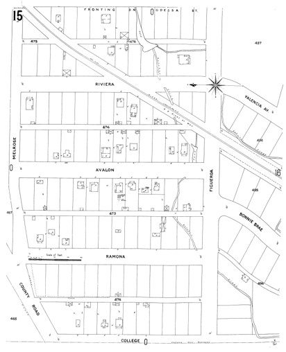
The first edition of the Sanborn Fire Insurance Map shows Butcher Creek running across what became Lot 2 and a small outbuilding in the northwest corner. Lots 17 and 18 can be seen, each marked “D” for dwelling, but Lot 16 is unnumbered.
12/26/1902, Affidavit, H. C. Baker to The Public, to verify the warranty deed of 1867, that William O. Green died in the Spring of 1878, and that all grantors mentioned in the above Quit Claim Deed were the issue of W. O. and Mary F. Green.
10/3/1903, Agreement for Deed, Mary F. Green, grantor; Charles I. Hall, grantee, Lots 14, 15 and 16, Block 2, $600 in gold coin on or before 2 years at 7% interest per annum. The 1898 City Directory listed Charles I. Hall as manager of Western Union Telegraph Company with residence at 33 Chase Avenue. By 1902, Hall was listed as residing in Green’s Addition. In both the 1903 and 04 City Directory he was listed as a farmer with residence in Green’s Addition, but by the 1905 edition his residence was listed as Garden Heights Addition to the east of Green’s First Addition. In the 1906 City Directory he was still listed as a farmer, but with residence at 309 North 2nd. He was not listed in the 1909-10 City Directory.
10/3/1903, Quit Claim Deed, Charles I. and Anna M. Hall, grantors; Mary F. Green, grantee, for the above-mentioned lots, $600. It seems, therefore, that Charles I. Hall never lived in the house on Bonnie Brae Street.
10/3/1903, Agreement for Deed, Mary F. Green, grantor; T. J. Stanfield, grantee. This agreement was for the same three lots listed above, $1 at the time of delivery, $100 on or before 10/3/1904, 1905, 1906 and 1907, and $199 on or before 10/3/1908. The 1889 and 1892 City Directories listed Stanfield residing on Touchet Street at the northwest corner of Cherry Street. In 1902, 03 and 04 he was listed as a teamster living in Green’s Addition. By 1905-07, Stanfield was listed as a clerk still in Green’s Addition.. He was listed in the 1909-10 City Directory as a farmer, residing at 3 Avalon Street which in all likelihood is the first address for what became 1007 Bonnie Brae Street. The 1908 directory lists him as a laborer, and Roy Stanfield, at the same address, then described as Figueroa, was a student at the Fischer School of Music. Eventually T. J. and Roy Stanfield owned and operated Stanfield & Son Cigars at 218½ East Main Street.
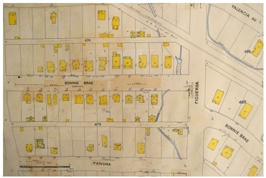
The first addition to the 1905 Sanborn map was made in July 1909. The house at 1007 Bonnie Brae Street can be seen. Note that the street name has been changed to Bonnie Brae with Avalon in parentheses.
6/8/1908, Quit Claim Deed, Mary F. Green, a widow, grantor; The Green Investment Company of Walla Walla, a corporation, regarding the transfer of unsold property in Green’s First Addition to the investment company that she had formed. This transfer excluded Lots 14, 15 and 16 of Block 2.
3/6/1919, Indenture, The Green Investment Company, grantor; T. J. Stanfield, grantee, Lots 14, 15 and 16, Block 2, $600 in gold coin.
6/23/1920, Lien, City of Walla Walla to T. J. Stanfield, $191.45 for sidewalks, Lots 14, 15 and 16.
6/3/1925, Release of Lien.
8/7/1942, Warranty Deed, Anna J. Stanfield, a widow, grantor; Virginia Harris, a spinster, Lot 16, Block 2, $1,000.
6/29/1945, Warranty Deed, Virginia Harris Hendrickson and Paul Hendrickson, grantors; Minnie Harris Van Nattan and V. E. Van Nattan, grantees, Lot 16, Block 2, $1 and other valuable consideration.
6/10/1960, Seller’s Assignment of Real Estate Contract and Deed, Minnie Harris Van Nattan, a widow to First Federal Savings & Loan Association of Walla Walla, a real estate contract dated 3/23/1960 to Donald L. and Helen S. Brooks, $3,945.19.
1/11/2006, Statutory Warranty Deed, Mary K. Brooks, personal representative of the Estate of Helen Shirley Brooks, deceased, grantor; Joshua Roy Redberg, Terry Redberg and Emma Jean Redberg, grantees, Lot 6, Block 2, $10 and other valuable consideration.
8/16/2010, Warranty Deed, Joshua Roy Redberg, grantor; Kamron and Cicely Coleman, grantees, $163,000.
10/14/2014, Quit Claim Deed, Kamron and Cicely Coleman, grantors; Cicely Coleman, grantee.
4/5/2018, Statutory Warranty Deed, Cicely Coleman, grantor; Shayne C. Hollandsworth, grantee.
Construction of Building
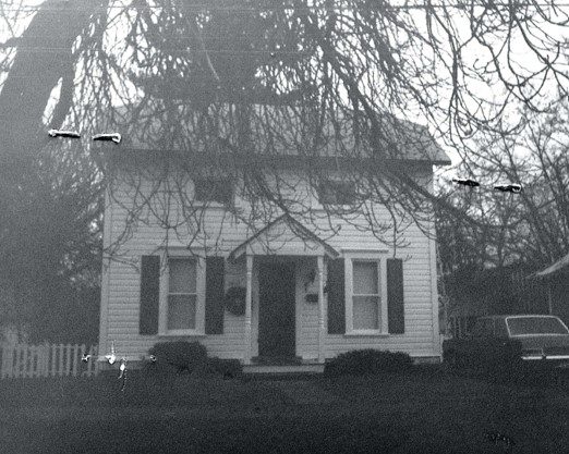
1007 Bonnie Brae Street in December 1997. Walla Walla County Assessor photo.
The Walla Walla County Assessor dates 1007 Bonnie Brae Street to 1900. This is frequently a “default” date for an old house for which there exists no concrete information, but from the appearance of this house it would almost appear to be close except for the fact that in the first edition of the 1905 Sanborn Fire Insurance Map the house is not there, nor is Lot 16 identified. Yet as early as 1902 Thomas J. and Anna Stanfield with their son Roy were listed as living in Green’s Addition. While it does not state Green’s First Addition, it would not have been Green’s Park Addition that was not platted until 1903. Perhaps before Green’s Park was platted Green’s First was simply known as Green’s Addition. There is no clear way of determining if the Stanfields lived somewhere else in Green’s First Addition prior to being listed at 3 Avalon Street, later 1007 Bonnie Brae Street, in 1909. Since the date on the title page of the 1905 Sanborn map does not mention a month, could the house have been built sometime in 1904, but not completed in time to be included in the 1905 map? (The mansion built at 925 Isaacs Avenue for Mary F. Green’s daughter Philinda Green Langdon and son-in-law John Langdon was completed in 1905, but it, too, is not included in the first edition of the 1905 Sanborn map.) City of Walla Walla building permits, housed at Whitman College Archives, do not exist earlier than September 1907. No building permit could be located through 1909; that establishes the house was constructed prior to September 1907. This being the case, a construction date of “circa 1906” is recommended. What also can be established is that it was built by Thomas J. and Anna Stanfield, who clearly lived in Green’s First Addition, although they did not have a street address at 3 Avalon Street until 1909.
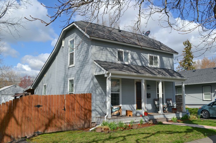
In form and style, the house at 1007 Bonnie Brae Street resembles an early farmhouse, a saltbox of one and one-half stories, a style that originated in the 17th century. It features a hip-on-gable roof (note the canted ends of the main gable). The rear slope of the roof has two angles; a vertical strip on the side of the house delineates this break in the roof’s slope, suggesting that the back portion of the house may have been a later extension. The house was constructed for a family of three, however, which probably overrules that thought, as does its footprint in the 1909 additions to the 1905 Sanborn map.
The house has a centrally-massed façade, with strict symmetry. The low windows at the second level of the street façade clearly indicate limited headroom upstairs. The full-width covered front porch is a recent addition, and provides a pleasant place to sit.
Although no building permit exists for 1007 Bonnie Brae Street, City of Walla Walla Development Services revealed that a permit was issued in 2008 for new siding and windows. The reasonably older photo from December 1997 (below) shows the house was clad in shiplap siding, and that is also the current siding that evidently dates to 2008. Former windows were single pane double hung; current windows are multi pane double hung and may be thermal. What was not included on the 2008 building permit is the full-width front porch. The 1997 photo shows a small gabled front porch, not common for this style of house, with lathe-turned porch posts that likely were original to the house.
References
- TitleOne Title and Escrow (formerly Pioneer Title)
- Whitman Archives
- Walla Walla Public Library
- Walla Walla City Directories, various years
- Walla Walla Auditor online deed search
- Walla Walla Auditor Direct and Reverse Indexes to Deeds
- Bureau of Land Management online patent search
- Standard Atlas of Walla Walla County, Washington, Including a Plat Book of the Villages, Cities and Townships of the County, George A. Ogle & Company, Chicago, 1909
- Sanborn Fire Insurance Maps, various years up to the 1905 edition, including updates to that edition added over various years
- Jonathan Maland, Senior Planner, City of Walla Walla Development Services