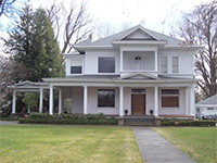
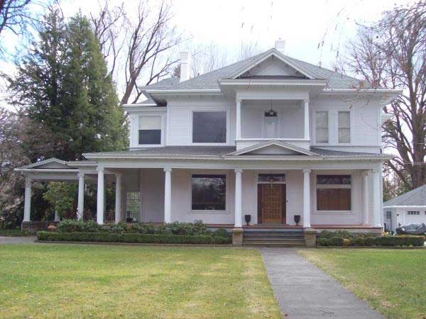
History of 330 Craig Street, Walla Walla, WA
Legal Description (abbreviated):
Parcel A–begin at corner Park and Craig Sts., thence Southerly along west line Park 185 feet, thence Westerly 195 feet. thence Northerly 60 feet, thence Westerly 8 feet, thence Northerly 125 feet. thence Easterly along south line Craig St. 203 feet to the point of beginning. Parcel B–begin at point 185 feet south of corner Park and Craig Sts., thence Southerly 115 feet, thence Westerly 185 feet. thence Northerly 115 feet, thence Easterly along south line of Parcel A 185 feet to the point of beginning
Title and Occupant History:
June 10, 1870-A. B. and Martha E. Roberts, husband and wife, sold the real estate describer below to James W. Law for $1000. Begin at intersection Craig & Ebbie [park] Sts thence S. 68 degrees 30 minutes W. 8 chains & 47 links [590 feet] to center line Warner St., thence Southerly 7 chains & 75 links [560.5 feet] to South line A. B. Roberts claim, thence East along South line of said claim to intersection with Ebbie [Park] St. thence Northerly II chains [726 feet] to place of beginning, being 7 82/100 acres more or less. (Deed Book G, Page 264, hereinafter G/264) January 10. 1872–James W. Law sold the above property to Noah Flickinger for $1000. (I/464) December 4. 1874–Noah Flickinger deeded the property above to Emma H. Flickinger for $500. (N/226) May 16, 1876–an Indenture was made between George F. Thomas, Sheriff of Walla Walla County, Washington Territory. and Benjamin L. Sharpstein regarding the sale at auction, July 31, 1875. of the real estate described below to B. L. Sharpstein for $75. This resulted for a judgement in District Court. May 12. 1874. in favor of the plaintiff Daniel Martin and against Alvin B. Roberts and Martha E. Roberts. defendants. Real Estate: Block F in A. B. Roberts Addition plus begin at point 237 feet west from from S.W. corner of A. B. Roberts Addition on South boundry of said Addition at S.E. corner of piece land sold to James Law by A. B. Roberts, thence on East boundry said land N. 22 degrees W. 726 feet to south line Craig St., thence Easterly on south line Craig St. 100 feet, more or less, to west line Ebbie [Park] St., thence Southerly on west line Effie St. to South boundry of said A. B. Roberts Addition, thence West 210 feet, more or less, to place of beginning, containing 2 & 717/1000ths acres, more or less. (N/223) B. L. Sharpstein was a Mexican War veteran, pioneer, lawyer, and judge. He came west from Wisconsin in 1865 and resided in Walla Walla for 42 years. In 1866 he was elected to the territorial legislature; he was twice re-elected. He was active in advancing standards for schools and improvement of instruction and was a member of the school district board of directors. Sharpstein School was named in his honor. He was one of three Walla Walla members of the Constitutional Convention of Washington Territory which met in Olympia, July 12, 1889, and prepared a constitution for statehood. He died May 3, 1907 at his home at 365 Catherine St. (W. D. Lyman. Lyman’s History of Old Walla Walla County, Chicago: S. J. Clarke Publishing Co., 1918, Vol. I, 288; and Robert A Bennett, Walla Walla: portrait of a Western Town. 1804-1899. Walla Walla: Pioneer Press Books, 1980, 141.) October 5, 1880–Emma A. and Edward Flickinger sold the property described in G/264 to A. Reeves Ayres for $2500. (W/83) The 1880 city directory lists A. Reeves Ayres as clerk of the First Judicial District Court with a residence on First between Birch and Dr. Newell Sts. May 21, 1881–B. L. and Sarah J. Sharpstein quit claimed and conveyed their interest in the real estate described in N/223 to A. Reeves Ayres for the recorded consideration of $1. (W/85) July 13, 1881–A. Reeves and Elvada G. Ayres, husband and wife, deeded the property described’ below to John A. Paddock, Bishop of Washington Territory, for $3500. Commence at the intersection of Park and Craig Sts., thence along south line of Craig St. 170 feet, thence S. 68 degrees 30 minutes W. 310 feet, more or less, to the center line of Roberts St., thence along center line Roberts St. in Southwesterly direction 600 feet, more or less, to south boundry A. B. Roberts Addition, thence East along south line A. B. Roberts Addition 580 feet, more or less, to the west line of Park St., thence along west line Park St. Northwesterly 825 feet, more or less, to the point of beginning. (W/260) January 16, 1882–John A. Paddock, Bishop of Washington Territory, deeded the real estate described above to the Trustees of the Protestant Episcopal Church of Washington Territory, a corporation, for $3500. (Y/30) October 9, 1893–the Board of Trustees of the Protestant Episcopal Church in Washington Territory, a corporation, sold the real estate described above to the Board of Trustees (L. H. Wells, V. Marshall Law, John F. Boyer, E. B. Whitman, and B. L Sharpstein) of St Paul’s School for $1 “and other valuable consideration.” (71/124) July 10, 1899-L. H. Wells, V. Marshall Law, E. B. Whitman. B. L. Sharpstein. John F. Boyer, and Eugene H. Boyer, executors of the will of John F. Boyer, deceased. sold the real estate described below to St. Paul’s School. a corporation, for the recorded consideration of $1. (72/119) Real Estate: begin at the intersection of Park & Craig Sts., thence along south line Craig St. in Southwesterly direction 170 feet to point where south line of Craig crosses the north line of the land conveyed by A. B. Roberts and wife to James Law (G/264), thence along said north line in direction S. 68 degrees 30 minutes W. 310 feet, more or less, to center line Roberts St., thence along Roberts St. in Southeasterly direction 600 feet, more or less. to south boundary Roberts Addition, thence E. along south line Roberts Addition 580 feet, more or less, to W. line Park, thence along W. line Park northwesterly 820 feet to place of beginning. John F. Boyer, brother-in-law of Dorsey S. Baker, was a partner in the firm of Baker and Boyer, a merchandising business, and the first president of the Baker-Boyer National Bank. He died in 1897. November 20, 1899–St. Paul’s School, a corporation. filed the plat of St. Paul’s School Addition to the City of Walla Walla. (Plat Book C, Page 18, Walla Walla County Auditor’s Office, Walla Walla County Courthouse) April 5, 1900–St. Paul’s School, a corporation, sold Mary Esther Baker [first wife of W. W. Baker] all of Block E of St. Paul’s Addition, except lots 7 & 8, for $3890. This is the Block containing the property in the legal description. (73/349) April 17, 1900–Walla Walla City Ordinance No. 701 was passed: an ordinance to vacate the alley in Block E of St. Paul’s Addition to the City of Walla Walla, “the ownership of said Alley to vest in the owners of the abutting property as provided by law.” (113/644) March 4, 1901–Mary Esther Baker deeded her husband W. W. Baker several properties including all of Block E except lots 7 & 8 and a strip off of the North end of lots 9 & 10 for the recorded consideration of $1. (95/111) The city directory for 1900-1901 lists W. W. Baker with a residence 1 1/2 miles S.E. of the city; in 1902 he is listed as the president of Baker Loan & Investment Co., 8 S. 2nd, with a residence near the S.W. comer of Craig and Park Sts. (see articles attached) Construction of the House: The county assessor lists the year built as 1910, but from the purchase dates and the city directory information, the house was probably built in 1901, although 1900 is a possibility also (if it were built too late to get in the 1900-01 directory). W. W. Baker is listed as residing at 330 S. Craig in the city directories for 1902-1948; the directories for 1949-1977 list Emma J. Baker, widow of W. W. Baker, at the address. December 16, 1952–Howard D. Baker, William Baker Ferguson, and D. F. Baker, as trustees of the will of Mildred Baker Ferguson, quit claimed and conveyed the property described below to William Baker Ferguson and Janet Ferguson Campbell.
Parcel I: begin at point on south line Craig St. 100 feet east of intersection Palouse and Craig Sts., thence Easterly along Craig 82 feet, thence Southerly 170 feet, thence Westerly 82 feet, thence Northerly 170 feet to place of beginning.
Parcel 2: begin at point 182 feet east of intersection Palouse and Craig, thence Easterly along Craig 54 feet, thence Southerly 170 feet, thence Westerly 54 feet, thence Northerly 170 feet, more or less, to place of beginning. (Deed # 360109)
May 18, 1978–the Whitman College Board of Trustees turned down the gift of the W. W. Baker house for the Whitman College President’s residence. (Minutes of the Whitman College Board of Trustees, Whitman College Archives) October 17, 1978–James S. Eagleson, as personal representative of the estate of Emma Jones Baker, deceased, and of Howard D. Baker, deceased, the Baker-Boyer National Bank in Trust under the will of Dorsey S. Baker, deceased, William Baker Ferguson, Janet Ferguson Campbell, and Geneva Sims Baker, widow of Howard D. Baker, sold parcels A & B in the legal description to Orrin M. Anderson for $134,000. (#7810552) The 1979 city directory lists Orrin M. Anderson as a farmer, Anderson Corp., with a home at 330 Craig. July 19, 1979–0rrin M. Anderson sold parcels A & B to Laurel Hill Enterprises, Inc. for $155,000. (#7906768) The 1980-1986 directories list Jim Clay and his wife, Rita Clay, as co-owners of a nursing home chain with a residence at 330 Craig. November 3, 1987–Laurel Hill Enterprises, Inc., sold parcels A & B to Douglas E. Breen, a single person, and Malinda S. McKee, a single person, for $180,000. (#8708261)
prepared by Michael W. Smith, 2/96


