Welcome to the History of Luckinbill Crossing Website
Geology
 The bedrock of southeastern Washington and adjacent states is hundreds of lava flows that occurred 17 to 6 million years ago during the Miocene epoch. The magma rose through the Earth’s mantle and crust as a mantle plume or hotspot similar to those
in Hawaii and Yellowstone National Park. The Columbia River basalts, thousands of feet thick, erupted from fissures in eastern Oregon, southeastern Washington, and westernmost Idaho. Some of the lavas were so voluminous that they flowed through
ancestral Columbia River gorges all the way to the Pacific Ocean. Before the eruption of the last basalt, the Touchet River began cutting this meandering valley.
The last of five ice ages occurred during the Pleistocene epoch which began about 2 million years ago. Ice ages are characterized by alternating glaciations and warm periods. During each glaciation ice covered much of North America from British Columbia to Labrador. Part of the ice advanced south into northern Washington, Idaho, and Montana. The lobe in northern Idaho dammed Clarks Fork to create Glacial Lake Missoula, the size of one of our Great Lakes. The rupture of this dam released an enormous flood that rushed through Spokane, across much of eastern Washington, through Wallula Gap and the Columbia River Gorge, and into the Willamette Valley and the Pacific Ocean.
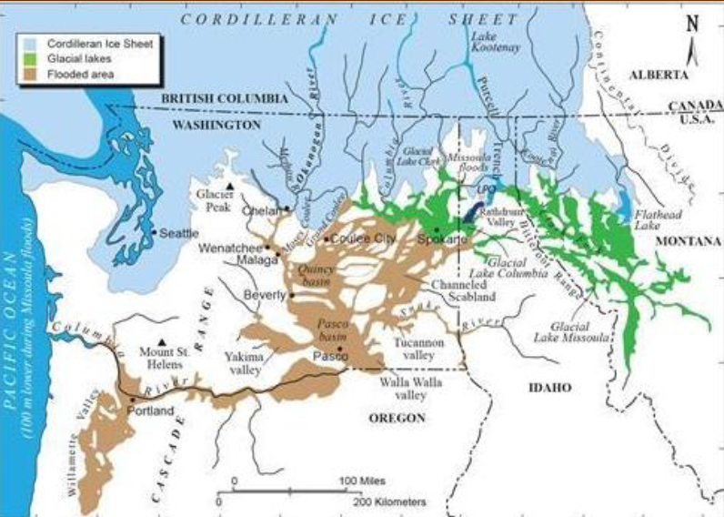 The ice dam reformed and another flood occurred; this was repeated dozens of times from 18,000 to 15,000 years ago. The furious floods eroded the Channeled Scabland of eastern Washington, and deposited giant gravel bars and the Touchet beds. Constricted at Wallula Gap, the floods rushed up the Walla Walla, Touchet, and other rivers. Each Touchet bed consists of a basal layer of sand; as the floodwaters slowed, an upper layer of silt was deposited. In the Walla Walla Valley 40 Touchet beds represent 40 Missoula floods.
For millions of years sediment has been accumulating in the Pasco and Umatilla basins. Sources of the thick sediment include many rivers, glacial meltwater, and the Missoula floods. The prevailing southwesterly winds erode this sediment. The blowing sand travels short distances to become the Juniper Dunes northeast of Pasco and dunes on Eureka Flat north of here. However, the silt gets suspended and travels long distances to make the Palouse Hills. Loess, or wind deposited silt, covers the hilltops near here. Since the last Missoula flood the Touchet River and its tributaries have been eroding the Touchet beds and the loess to deposit this floodplain.
A good exposure of the basalt bedrock is in the quarry just to your west. Follow Luckenbill Road northwest to see Touchet beds (tan, layered) overlain by Palouse Loess (tan, vertical joints). Within 2 miles you will be atop Eureka Flat with its long linear dunes slowly migrating northeast in the prevailing wind. References: Carson, 2008, Where the Great River Bends; Carson, 2015, Many Waters
Wildlife
 The beautiful Touchet River is born high in the northern Blue Mountains. As its clear waters race down, three branches form the Touchet river as it flows onto the flood plain running west across central Walla Walla County. The cold waters host currently endangered native species of fish such as the sea run Steelhead Trout and Bull Trout along with other native and non-native fish species.
There are also many native breeding bird species here, both neo-tropical migrants and resident birds. Some of these spectacular birds are the Western Tanager, Lazuli Bunting, Bulock’s Oriole and the American Goldfinch. Other birds are Bald Eagle, Cooper’s Hawk, Common Nighthawk, and Great Horned Owl to name a few. In addition, several game birds have been introduced to replace two native species that were lost through destruction of habitat and over hunting, the Columbia Sharp-tailed Grouse and the Greater Sage Grouse.
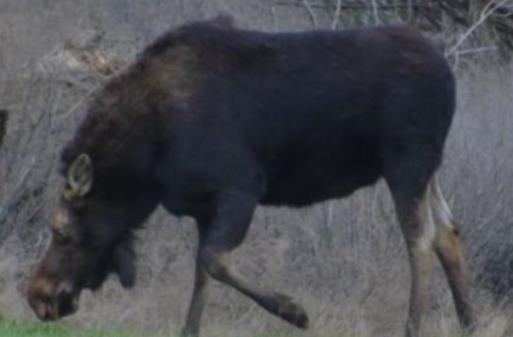
 Other wildlife that live along this river are the Western Skink lizard, Pacific Gopher Snake, Western Rattlesnake, Long-toed Salamander and Woodhouse’s Toad. Small mammals also flourish along this stream. They are long-tailed Voles, Ords Kangaroo Rat, Mink,stream. They are long-tailed Voles, Ords Kangaroo Rat, Mink, American River Otter and American Badger. Larger mammals here are the Coyote, Bobcat, Mule and White-tailed Deer as well as Moose.
The other important part of the story of the Touchet River are the many native plant communities that grow and allow for a great diversity of insects such as pollinators, butterflies and ants, beetles and native bees. The riparian buffers along this river provide 82% of all local animals here around you a place to live at some point in their life cycle. Because a large stretch of this river flows through an arid landscape that provides cover, forage and habitat year around, this tributary of the Walla Walla River is vital for all living creatures along its shores.
Native Peoples
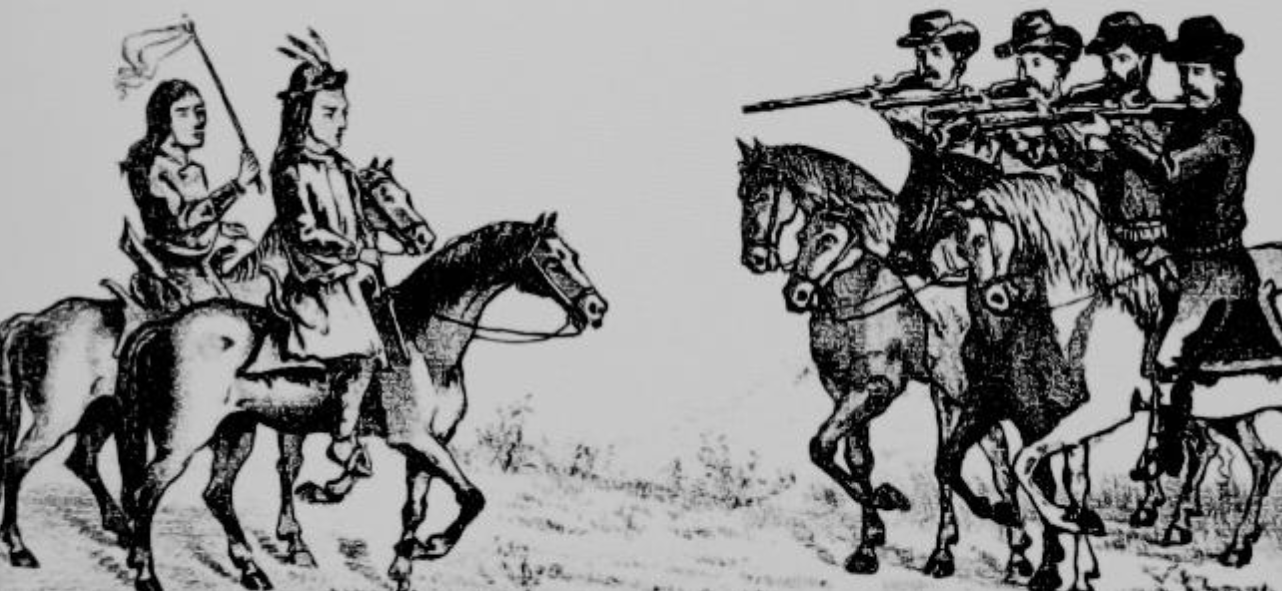
Sketch by Oregon Volunteer Geroge Hunter, 1887
Members of the Walla Walla Tribe were the earliest inhabitants of the area from the lower Touchet River down to the Columbia. Their Chief Peopeomoxmox was known for friendly relations with the employees of the Hudson’s Bay Company trading post at Wallula and other newly arrived Europeans until 1855. After the Walla Walla Treaty Council that year established reservations for many of the inland Indian Tribes, the Yakima Indian War broke out when whites began coming into Indian territory before the treaties were ratified.
In response, Walla Walla Indians sacked and burned a portion of the Wallula trading post, and Oregon Mounted Volunteers marched from the Willamette Valley to punish them. On December 5, 1855, Peopeomoxmox and fifty of his warriors waving a white flag of truce approached approximately 200 Oregon Mounted Volunteers near the Lewis and Clark campsite downstream from here on the Touchet River to delay the soldiers and protect the Walla Walla village just upstream from here.
Peopeomoxmox promised to return the trade goods from the Fort and to provide food for the hungry Volunteers at their village, but the Volunteers insisted that the Walla Walla Chief and five of his followers become their hostages, which they agreed to do.
On their way to the village the Volunteers became fearful of a surprise attack in the narrow gorge of the Touchet just above here, and waited to go to the village the next day, when they found it deserted with campfires still burning. The Volunteers and hostages then rode cross country to their base camp at the confluence of the Touchet and Walla Walla Rivers.
On December 7, 1855, when the Volunteers crossed the Touchet to begin their march up the Walla Walla Valley to establish a permanent camp at the ruins of the Whitman Mission, they became engaged in an eight-mile running fight with members of various Tribes. The fighting continued for four days in what became known as the Battle of Walla Walla, the longest in Washington State history, during which Peopeomoxmox and other hostages were killed by the volunteers before the warriors finally withdrew after Volunteer reinforcements arrived.
Luckenbill Cabin
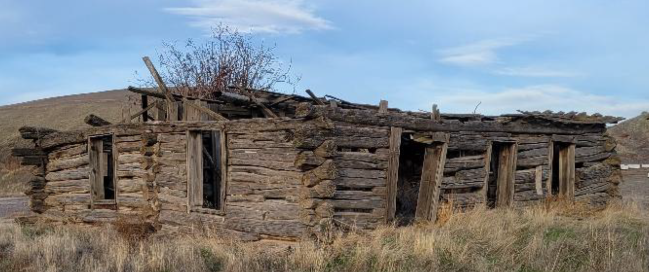 Among the early settlers along the Touchet River was Martin Luckenbill, one of the best-known pioneer farmers of this valley. He was a native of Pennsylvania, and crossed the plains in 1851 to California, where he prospected for several years in the mining district.
In 1863, Luckenbill came to the town of Walla Walla, where he engaged in the merchandising business. In 1874, he began farming and moved his home to the property just northeast of here, where he built the cabin which you can still see standing in the field across the river to your right. He continued to live here until 1907 when he moved back to Walla Walla, where he died in 1910 at the age of 75.
Walla Walla 2020 Historic Sites
This sign was placed by the Walla Walla 2020 Historic Sites and Markers Project in 2026. More information on Luckenbill history and other historic sites in the Walla Walla area is available at www.ww2020.net/history-websites.