
History of 627 Pearson Street, Walla Walla, WA
Legal Description
Lot 12 in Block 2 of the Amended Plat of Isaacs’ Third Addition to the City of Walla Walla, according to the official plat thereof, together with the tenements, hereditaments and appurtenances whatsoever to the same belonging or in any way appertaining.
Title and Occupant History
Washington Territory was created in 1853. In 1854, the new territorial legislature created Walla Walla County, which stretched from the crest of the Cascade Mountains to the crest of the Rocky Mountains in the present states of Washington, Idaho and Montana. In 1855, Isaac Stevens, governor of Washington Territory, held a council on the banks of Mill Creek at the present site of Walla Walla with representatives of regional Native tribes to purchase land from them. The Yakamas, Cayuses and Walla Wallas were dissatisfied with the treaties and the intrusion by whites into their lands before the treaties’ ratification, and war followed. Missionaries, former French-Canadian employees of the Hudson Bay Company trading post at Wallula, and soldiers at the military Fort Walla Walla were the primary European occupants of the area prior to 1859, when the treaties were finally ratified and the land was opened for settlement. The transfer of ownership occurred by virtue of a treaty signed on June 9, 1855 in Walla Walla and ratified on March 8, 1859 by President James Buchanan, in which all of the land in the Walla Walla area was acquired from the Cayuse and Walla Walla tribes.
The town of Walla Walla was originally laid out by County Surveyor Hamet Hubbard Case in 1859, prior to its formal incorporation as a city in 1862, as a one-quarter mile square with its eastern side centered on the point where Main Street crossed Mill Creek (at roughly the point where it does now). The original plat was lost, probably in the fire of 1865. Thus, the earliest plat on file is one made by W. W. Johnson, City Surveyor, in July 1865 that claims to have made corrections to Case’s survey. Johnson’s survey was made the official plat of the City of Walla Walla on September 25, 1866, was filed and recorded July 5, 1867.
The first recorded transaction involving 627 Pearson Street was on July 25, 1863 when John Haley sold “all that portion of the South West 1/4 of section No. 21 in Township No. 7, County of Walla Walla, Washington Territory” which was 26.81 acres “more or less” for “consideration $100.” The buyers were William H. and Elizabeth A. Patten who were early prominent land owners. Shortly thereafter on April 20, 1864 the Pattens sold the parcel to Henry P. Isaacs for
$2000 in gold coin. Isaacs was influential in the development of Walla Walla as a wheat growing area. Prof. W. J. Lyman in his 1918 History of Old Walla Walla County wrote that Isaacs “demonstrated to the farmers that wheat could be produced profitably on the hills and uplands which in those early days had been given over to stock-raising.” He built numerous flour mills throughout the Northwest and “his knowledge of the manufacture and handling of flour became renowned and he was recognized as an authority on all matters pertaining thereto.” He found markets for wheat in the Orient, especially China. The Isaacs and their son J.C Isaacs also founded the Walla Walla Water Company, providing Walla Walla with a reservoir, ditches, conduits and the possibility of irrigation of crops. The right to utilize “subterranean” water pertaining to the properties affected is included in several deeds in the area.
H.P. Isaacs died without a will in 1900. In 1903 the Isaacs heirs, his children, formed the H.P. Isaacs Company. The breaking up of the considerable Isaacs property resulted in the development of Isaacs’ Third Addition to the City of Walla Walla.
7/25/1863, Deed, John Haley, grantor; Wm. H. Patten and wife, all that portion of the South West ¼ of the North West ¼ of Section no. 21 in Township no. 7 North, Range no. 26 East bounded as follows: commencing at the quarter post on the East side of Section no. 20, thence running North 11.95 chains, thence North 81° East to the East boundary of said quarter quarter, thence South to the South East corner of said quarter quarter, thence West to the place of beginning, containing 26 and 81/100ths acres more of less, $100. John Haley was granted a patent on 7/15/1865 for 160 acres that included land located in the North East quarter of the North West quarter, the North West Quarter of the North West quarter and the South West Quarter of the North West quarter of Section 21 in Township 7 North, Range 36 East, as well as land in Section 20. The patent was issued through the Vancouver, W. T. Land Office. Little information could be located about John Haley (sometimes spelled Hailey) although he was briefly in 1881 co-owner/publisher of the East Oregonian newspaper in Pendleton.
4/20/1864, Warranty Deed, Wm. H. and Elizabeth A. Patten, grantors; H. P. Isaacs, grantee, beginning at the South West corner of the North West quarter of the South West quarter of Section 21 in Township 7 North of Range 36 East, thence East 80 rods, thence North 135 and ½ rods, thence West 81° South 118 and 88/100th rods, thence on a straight line to the place of beginning, containing 80 acres, and to be the same as contained in said boundary more or less in Sections 20 and 21 North of Range 36 East, Township 7, $2,000.
4/5/1866, Warranty Deed, William H. and Elizabeth A. Patten, grantors; Henry P. Isaacs, grantee, (same as Warranty Deed of 4/20/1864), $2,000.
9/22/1881, Lease, H. P. and Lucie Isaacs, lessors; J. C. Isaacs, lessee, (same as Warranty Deed of 4/20/1864), including to “take and conduct away the subterranean waters on and in the land hereinafter, described to the extent and in the manner the said right is now exercised and enjoyed by the party of the second part, for the purpose of supplying the City of Walla Walla and the inhabitants thereof with water and to use and employ all necessary means for the accomplishment of said result, and the right to extend the present ditch on the North East corner of the reservoir on said land in a Northeasterly direction as far as may be necessary to develop and increase the supply of water and the right to maintain the ditches and reservoir and building enclosing the same, and to make all necessary and needful repairs and the right to have, hold and occupy so much of said land as is covered by the reservoir now constructed, together with a strip 15 feet wide and surrounding said reservoir for use in connection therewith,” $10,000.
9/11/1886, Deed, H. P. Isaacs, grantor; The Walla Walla Water Company, a corporation, grantee, “The sole and exclusive right to enter upon and take and conduct away all subterranean water upon or in the land hereinafter described in manner as the said right has heretofore been enjoyed and exercised by the party of the second part, and the right and privilege to maintain the reservoir now maintained on said land by the party of the second part, together with all ditches and conduits leading to or from said reservoir, and the right to have, hold and occupy so much of said hereinafter described land as is now covered by the said reservoir and the building enclosing the same, together with a strip of land 15 feet wide extending all around and adjoining said reservoir building, and also the further right and privilege to execute, construct and maintain such other outlet than now maintained for said reservoir as may be necessary or convenient for the party of the second part, its successors or assigns and to extend the present ditch or conduit leading water into said reservoir in a Northeasterly direction so far as may be necessary or convenient to increase the water supply in said reservoir, and in order to use and enjoy said above enumerated rights and privileges to the fullest extent the said party of the second part shall have the right to go upon said land and dig and excavate and make all necessary, needful or convenient repairs, and to use and employ all necessary means thereto at any time or times hereafter. The land above referred to and in which said easement above described are hereby granted and conveyed (see Warranty Deed of 4/20/1864), plus 34 and 25/100ths acres in the same Section, Township and Range, the latter with the following conditions: Any ditch dug, opened or excavated under or by virtue of this conveyance shall be covered in a good and substantial manner and without unnecessary delay, and no buildings, fruit trees or shade trees shall be interfered with in any manner not absolutely necessary, and then at the damage and expense of the party of the second part only, and there shall be no unnecessary interference with or damage to growing crops, $1 and other valuable consideration.
6/27/1894, Quit Claim Deed, Lucie Isaacs, grantor; Henry P. Isaacs, grantee, property described as, “beginning at the South West corner of the North West quarter of the South West Quarter of Section 21, Township 7 North, of Range 36 East, and running thence due East 80 and thence due North 135½ rods to a stake, thence South 81° West 118 88/100ths rods, to a stake, thence on a straight line to the place of beginning, containing about 80 acres, and to be the same as contained in said boundary more or less in Sections 20 and 21 in Township 7 North, of Range 36 East, $1.
3/28/1896, Warranty Deed, H. P. and Lucie Isaacs to Miles C. Moore, H. P Baker and W. W. Baker, Trustees, in which for the sum of $20,000 the parties of the second part and their heirs were assigned numerous real estate in Walla Walla County, too numerous to record here, but lying in Sections 21 and 22, including land on which H. P. Isaacs’ Pacific Mill “A” was located and the Mill Race. Also “the road…passing Easterly from Whitman College is to be dedicated subject to the rights of the parties of the second part or their heirs or assigns, and is to be extended and sufficient land for that purpose is hereby conveyed to extend the same of its present width in an Easterly direction until the same intercepts the Mill Race aforesaid.”
12/2/1899, Warranty Deed Against Grantors, Miles C. Moore, H. C. Baker and W. W. Baker, Trustees, grantors; The City of Walla Walla, a Municipal Corporation, grantee, real estate, too numerous to record here, lying in Sections 21 and 22, Range 7 North, Township 36 East excluding small parcels previously deeded by H. P. Isaacs, including land on which the Pacific Flouring Mill “A” had been erected, including all water rights. Also land in Sections 23 and 14, $1.
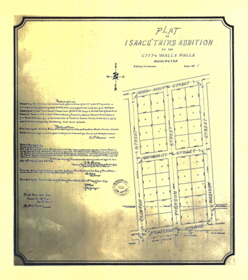
The plat map for the original Isaacs’ Third Addition is dated 1899, a year before an amended plat was filed.
5/17/1900, Ordinance, The City of Walla Walla to The Public. The City of Walla Walla does ordain…that the plot of Isaccs’ Third Adition..be and the same is hereby vacated; and the amended plot…is hereby substituted…and approved by the Common Council of the City of Walla Walla…May 1, 1900.
11/22/1901, Quit Claim Deed, Lucie Isaacs and Bessie Savage (formerly Bessie Isaacs), grantors; Grace G. Isaacs, Charlotte Doheny (formerly Charlotte Isaacs), Edwin Isaacs and J. P. Isaacs, grantees to remise, release and forever quit-claim unto parties of the second part…Lot 9 in Block 13 of Isaacs’ Addition, all of Lot 6 less portion conveyed to Allen H. Reynolds in Block 2, Lots 1 and 2 in Block 3, Lot 1 in Block 1, all in Isaacs’ Second Addition; all of Lots 1, 2, 3, 5, 6, 7, 8, 12, 13 and 14 in Block 1, all of Lots 1, 2, 3, 5, 9, 10, 12, 13 and 14 in Block 2; all of Lots 1, 2, 3, 5, 6, 10 and 12 in Block 3 in Isaacs’ Third Addition, $1.
7/18/1903, Quit Claim Deed, Grace Isaacs, Edward Isaacs, J. P. Isaacs, grantors; Charlotte Doheny, grantee, all lots lying in Isaacs’ Third Addition plus other properties, $1.
10/17/1904, Warranty Deed, Charlotte and J. J. Doheny, grantors; Lora Rees Compton, grantee, Lot 12, Block 2 of Isaacs’ Third Addition, $600. This deed marks the first sale of Lot 12 alone. Lora Rees Compton was a daughter of Raymond and Augusta Rees. With William Winans, Raymond Rees constructed the Rees Winans Building on the northeast corner of 2nd and East Main Streets in 1890, Walla Walla’s most florid Victorian extravaganza. Regrettably, the building was unsympathetically remodeled in 1951 and remains today as the renamed and architecturally spartan Jones Building.
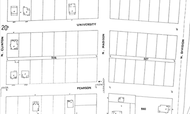
The first edition of the 1905 Sanborn Fire Insurance Map does not include the house at 627 Pearson Street.
2/6/1906, Indenture, Paul and Lora Rees Compton, grantors; Mrs. E. A. Preston, a widow, grantee, Lot 12, Block 2, $850. No information could be located on Mrs. E. A. Preston or an E. A. Preston in Walla Walla city directories.
3/17/1907, Indenture, J. J. Doheny et ux, grantor; Puget Sound National Bank, grantee, Lots 1, 3 and 12 in Block 2, unrecorded amount “in gold coin.”
8/19/1921, Quit Claim Deed, Charlotte and J. J. Doheny, grantors; Mrs. E. A. Preston, a widow, grantee, Lot 12, Block 2.
10/26/1921, Warranty Deed, Mrs. E. A. Preston, a widow, grantor; Arthur F. and Caroline Casper, grantees, Lot 12, Block 2, $10. Arthur Casper was a bookbinder employed by Washington Printing & Book Manufacturing Company at 115 East Alder Street.
1/7/1922, Affidavit, W. W. Baker to The Public, to verify that neither he, H. C. Baker nor Miles C. Moore had any interest in the property and merely acted as Trustees, as per the Deed recorded on 3/28/1896.
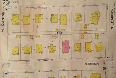
The January 1923 update to the 1905 Sanborn map shows 627 Pearson Street in place. Yellow indicates frame construction; pink denotes brick or masonry construction.
3/17/1922, Warranty Deed, Arthur F. and Caroline Casper, grantors; Susie Vaughan, a widow, grantee, Lot 12, Block 2, $10. Susie Royse Vaughan (1852-1929) was the widow of William M. Vaughan (1838-1918). Mr. Vaughan was a farmer in the Dayton area, where both he and Susie are buried.
4/18/1929, Affidavit, J. C. Thomas to The Public, to verify that he is familiar with all grantors and grantees of Lot 2, Block 12 and that the sole consideration paid to the grantors was property of the grantees.
10/29/1929, Agreement for Deed, William L. Vaughan, a son of William M. and Susie Vaughan, Executor of the Last Will and Testament of Susie Vaughan, deceased, grantor; Horace and Saidee E. Hollenbeck, grantees, Lot 12, Block 2, $7,500 with $1,500 down payment and balance of $6,000 at 7% interest per annum. Horace Hollenbeck was born in Seattle in 1893. Sarah (Saidee) Hollenbeck was born in Spokane. They married in 1918. Horace died in Walla Walla 11/25/1929 shortly after he and Saidee purchased the house on Pearson and eight months before the deed of sale was filed on 8/1/1930. Saidee, who worked as a public school teacher, was last listed at 627 Pearson in the 1931-32 city directory, after which she lived on Boyer Avenue, although she continued to own 627 Pearson for another decade, during which time city directories indicate the house was occupied by a several renters.
8/1/1930, Deed, William L. Vaughan, grantor; Horace and Saidee E. Hollenbeck, Lot 2, Block 12, $7,500.
3/16/1931, Assignment, W. F. Ault to Larison Chevrolet Company of LaGrande, Oregon, the principal of $6,000 plus interest from the estate of Susie Vaughan, $1 and other valuable consideration.
2/16/1943, Warranty Deed, Saidee Hollenbeck, a widow, grantor; Victor H. and Anne Chastain, grantees, Lot 12, Block 2, $10 and other valuable consideration. The 1946 city directory (directories were not published every year during WWII) listed Victor Chastain as employed at Green & Jackson Drug Company on West Main Street.
2/16/1943, Guardian’s Deed, Saidee Hollenbeck as guardian of the estate of Virginia Ann and Horace Hollenbeck, minors, grantor; Victor H and Anne Chastain, grantees, notice is given that the party of the first part did sell at private sale…one-half interest of said minors to the real property sold to the parties of the second part for $2,475.
1/18/1954, Warranty Deed, Elizabeth Anne Chastain, grantor (as of 1953 only Elizabeth was listed as residing at 627 Pearson); Jerry Lee and Ruth J. Cundiff, grantees, Lot 12, Block 2 of the amended plat of Isaacs’ Third Addition, $10 and other valuable consideration. Jerry Cundiff (1927-2022) was listed initially as a clerk at Falkenberg Jewelers, owned by his father. The late Supreme Court Justice William O. Douglas, who worked at Falkenberg Jewelers when he was a student at Whitman College, is reported to have remained a close friend of the Cundiffs throughout his life. In time Jerry Lee Cundiff became owner of the store, which remains in the family to date.
8/30/1979, Statutory Warranty Deed, Jerry Lee and Ruth J. Cundiff, grantors; General Conference of Seventh-Day Adventists, a corporation, grantee, Lot 12, Block 2, $54,900. During the years of Adventist ownership it appears that the house may have been used as rental property. Various persons are listed as living at 627 Pearson including a Walla Walla Community College student and a man listed as retired who lived in the house for years.
Walla Walla city directories ceased publication with the 2000 edition.
10/1/2010, Quit Claim Deed, General Conference of Seventh-Day Adventists, grantor; Jean L. Clarke Life Estate, grantee, Lot 12, Block 2. No information could be found for Jean L. Clarke.
3/18/2011, Quit Claim Deed, Nell C. Davies, grantor; Jean Clarke, grantee, Lot 12, Block 2. A search of Walla Walla telephone directories did not locate Nell C. Davies, nor did a Google search. It may be that she was acting in a legal capacity for the General Conference of the Seventh-Day Adventists.
3/23/2011, Quit Claim Deed, Robert Rittenhouse, grantor; Jean Clarke, grantee, Lot 12, Block 2. Robert Rittenhouse was a professor of chemistry at both Seventh-Day Adventist Walla Walla College (now University) and Central Washington University. He did not occupy 627 Pearson.
3/23/2011, Quit Claim Deed, Louis G. Pecce, grantor, Jean Clarke, grantee, Lot 112, Block 2. Mr. Pecce’s legal claim to this property is not revealed.
1/31/2012, Warranty Deed, Jean L. Clarke Life Estate, grantor; Jon and Dana Martinez, grantees, Lot 12, Block 2, $186,100. No listing in telephone directories could be found for Jon or Dana Martinez, nor was a Google search productive.
12/18/2012, Warranty Deed, Jon and Dana Martinez, grantors; Richard Martinez, grantee, Lot 12, Block 2, $253,000. The 2013 Walla Walla telephone book shows that Richard Martinez resided at 627 Pearson. He was a professor of art at Whitman College and died in 2020.
12/18/2012, Quit Claim Deed, Kim Martinez, grantor; Richard Martinez, grantee, Lot 12, Block 2. A Google search revealed Kim Martinez resided at 627 Pearson as did Leon Rittenhouse and William and Warren Clarke, likely related to Jean Clarke.
11/7/2019, Warranty Deed, Richard Martinez, grantor; Susan Travis, grantee, Lot 12, Block 2.
9/21/2021, Deed, Susan M. Travis, grantor; Susan M. Travis Trust, grantee, Lot 12, Block 2.
Construction of Building
The County Assessor lists 1925 as the build date for 627 Pearson Street. Their dates frequently are estimates based on a building’s appearance. In fact, on 4/1/1922 building permit 3667 was granted to Susie Vaughan, listed as the widow of William M. Vaughan, for which she paid five dollars, to construct a house at this address, estimated to cost $9,000. W. H. Huntington, a leading contractor of the time, was the builder.
627 Pearson Street is a one and one-half story craftsman bungalow with a fore-and-aft gable roof. It is the only house on this side of the block that is not of frame construction. The first floor is clad in brick; the second floor, lacking exposed walls on the sides of the house, is stucco.
It has a large front porch, the roof of which is supported by two brick pillars. The façade is centrally massed, with a centered front door and large windows on each side that feature a row of six small panes across the top. There is a tripartite window centered under the gable at the second level, and low-rise “eyebrow” dormers that project from the roof on each side of the house. The architect remains undocumented. This is an attractive house and a contributing member to the neighborhood.
Resources
- TitleOne Title & Escrow (formerly Pioneer Title)
- Whitman Archives
- Walla Walla city directories (various years)
- Walla Walla telephone directories (for years after 200 when city directories ceased)
- Sanborn Fire Insurance Company maps )1905 and updates)
- Gilbert, Frank T., Historic Sketches of Walla Walla, Whitman, Columbia and Garfield Counties, Washington Territory and Umatilla County, Oregon, Printing and Lithographing House of A. G. Walling, Portland, 1882
- Lyman, Prof. William D., Lyman’s History of Old Walla Walla County, Embracing Walla Walla, Columbia, Garfield and Asotin Counties, Vol. 2, The S. J. Clarke Publishing Company, Chicago, 1918 findagrave.com


