History of 621 Pearson Street, Walla Walla, WA
Legal Description
Lot 11 in Block 2 of the Amended Plat of Isaacs Third Addition to the City of Walla Walla, Washington, according to the official plat thereof of record in the Office of the Auditor of Walla Walla County, Washington, in Volume C of Plats at Page 19. Situated in the City and County of Walla Walla, State of Washington.
Title and Occupant History
Washington Territory was created in 1853. In 1854, the new territorial legislature created Walla Walla County, which stretched from the crest of the Cascade Mountains to the crest of the Rocky Mountains in the present states of Washington, Idaho and Montana. In 1855, Isaac Stevens, governor of Washington Territory, held a council on the banks of Mill Creek at the present site of Walla Walla with representatives of regional Native tribes to purchase land from them. The Yakamas, Cayuses and Walla Wallas were dissatisfied with the treaties and the intrusion by whites into their lands before the treaties’ ratification, and war followed. Missionaries, former French-Canadian employees of the Hudson Bay Company trading post at Wallula, and soldiers at the military Fort Walla Walla were the primary European occupants of the area prior to 1859, when the treaties were finally ratified and the land was opened for settlement. The transfer of ownership occurred by virtue of a treaty signed on June 9, 1855 in Walla Walla and ratified on March 8, 1859 by President James Buchanan, in which all of the land in the Walla Walla area was acquired from the Cayuse and Walla Walla tribes.
![Patent for 160 acres granted 7/15/1865 at the Washington, D. C. Land Office “in favor of John Haly [sic], Private, Company D, 4th Regiment, U. S. Infantry, Rogue River War.](https://ww2020.net/wp-content/uploads/621-pearson-2.png)
Patent for 160 acres granted 7/15/1865 at the Washington, D. C. Land Office “in favor of John Haly [sic], Private, Company D, 4th Regiment, U. S. Infantry, Rogue River War.
The first recorded transaction involving 621 Pearson Street was on July 25, 1863, when John Haley sold “all that portion of the South West 1/4 of Section No. 21 in Township No. 7, County of Walla Walla, Washington Territory” which was 26.81 acres “more or less” for “consideration $100.” The buyers were William H. and Elizabeth A. Patten who were early prominent land owners. Shortly thereafter on April 20, 1864 the Pattens sold the parcel to Henry P. Isaacs for $2000 in gold coin. Isaacs was influential in the development of Walla Walla as a wheat growing area. Prof. W. J. Lyman in his 1918 History of Old Walla Walla County wrote that Isaacs “demonstrated to the farmers that wheat could be produced profitably on the hills and uplands which in those early days had been given over to stock-raising.” He built numerous flour mills throughout the Northwest and “his knowledge of the manufacture and handling of flour became renowned and he was recognized as an authority on all matters pertaining thereto.” He found markets for wheat in the Orient, especially China. The Isaacs and their son J.C Isaacs also founded the Walla Walla Water Company, providing Walla Walla with a reservoir, ditches, conduits and the possibility of irrigation of crops. The right to utilize “subterranean” water pertaining to the properties affected is included in several deeds in the area.
H. P. Isaacs died intestate in 1900. In 1903, the Isaacs heirs, his children, formed the H. P Isaacs Company. The breaking up of the considerable Isaacs property resulted in the development of Isaacs’ Third Addition to the City of Walla Walla.
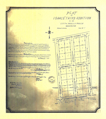
Isaacs’ Third Addition, signed 12/19/1899.
7/25/1863, Deed, John Haley, grantor; Wm. H. Patten and wife, grantees, all that portion of the South West ¼ of the North West ¼ of Section no. 21 in Township no. 7 North, Range no. 26 East bounded as follows: commencing at the quarter post on the East side of Section no. 20, thence running North 11.95 chains, thence North 81° East to the East boundary of said quarter quarter, thence South to the South East corner of said quarter quarter, thence West to the place of beginning, containing 26 and 81/100ths acres more of less, $100. John Haley was granted a patent on 7/15/1865 for 160 acres that included land located in the North East quarter of the North West quarter, the North West Quarter of the North West quarter and the South West Quarter of the North West quarter of Section 21 in Township 7 North, Range 36 East, as well as land in Section 20. The patent was issued through the Vancouver, W. T. Land Office. Little information could be located about John Haley (sometimes spelled Hailey) although he was briefly in 1881 coowner/publisher of the East Oregonian newspaper in Pendleton.
4/20/1864, Warranty Deed, Wm. H. and Elizabeth A. Patten, grantors; H. P. Isaacs, grantee, beginning at the South West corner of the North West quarter of the South West quarter of Section 21 in Township 7 North of Range 36 East, thence East 80 rods, thence North 135 and ½ rods, thence West 81° South 118 and 88/100th rods, thence on a straight line to the place of beginning, containing 80 acres, and to be the same as contained in said boundary more or less in Sections 20 and 21 North of Range 36 East, Township 7, $2,000.
4/5/1866, Warranty Deed, William H. and Elizabeth A. Patten, grantors; Henry P. Isaacs, grantee, (same as Warranty Deed of 4/20/1864), $2,000.
9/22/1881, Lease, H. P. and Lucie Isaacs, lessors; J. C. Isaacs, lessee, (same as Warranty Deed of 4/20/1864), including to “take and conduct away the subterranean waters on and in the land hereinafter, described to the extent and in the manner the said right is now exercised and enjoyed by the party of the second part, for the purpose of supplying the City of Walla Walla and the inhabitants thereof with water and to use and employ all necessary means for the accomplishment of said result, and the right to extend the present ditch on the North East corner of the reservoir on said land in a Northeasterly direction as far as may be necessary to develop and increase the supply of water and the right to maintain the ditches and reservoir and building enclosing the same, and to make all necessary and needful repairs and the right to have, hold and occupy so much of said land as is covered by the reservoir now constructed, together with a strip 15 feet wide and surrounding said reservoir for use in connection therewith,” $10,000.
9/11/1886, Deed, H. P. Isaacs, grantor; The Walla Walla Water Company, a corporation, grantee, “The sole and exclusive right to enter upon and take and conduct away all subterranean water upon or in the land hereinafter described in manner as the said right has heretofore been enjoyed and exercised by the party of the second part, and the right and privilege to maintain the reservoir now maintained on said land by the party of the second part, together with all ditches and conduits leading to or from said reservoir, and the right to have, hold and occupy so much of said hereinafter described land as is now covered by the said reservoir and the building enclosing the same, together with a strip of land 15 feet wide extending all around and adjoining said reservoir building, and also the further right and privilege to execute, construct and maintain such other outlet than now maintained for said reservoir as may be necessary or convenient for the party of the second part, its successors or assigns and to extend the present ditch or conduit leading water into said reservoir in a Northeasterly direction so far as may be necessary or convenient to increase the water supply in said reservoir, and in order to use and enjoy said above enumerated rights and privileges to the fullest extent the said party of the second part shall have the right to go upon said land and dig and excavate and make all necessary, needful or convenient repairs, and to use and employ all necessary means thereto at any time or times hereafter. The land above referred to and in which said easement above described are hereby granted and conveyed (see Warranty Deed of 4/20/1864), plus 34 and 25/100ths acres in the same Section, Township and Range, the latter with the following conditions: Any ditch dug, opened or excavated under or by virtue of this conveyance shall be covered in a good and substantial manner and without unnecessary delay, and no buildings, fruit trees or shade trees shall be interfered with in any manner not absolutely necessary, and then at the damage and expense of the party of the second part only, and there shall be no unnecessary interference with or damage to growing crops, $1 and other valuable consideration.
6/27/1894, Quit Claim Deed, Lucie Isaacs, grantor; Henry P. Isaacs, grantee, property described as, “beginning at the South West corner of the North West quarter of the South West Quarter of Section 21, Township 7 North, of Range 36
East, and running thence due East 80 and thence due North 135½ rods to a stake, thence South 81° West 118 88/100ths rods, to a stake, thence on a straight line to the place of beginning, containing about 80 acres, and to be the same as contained in said boundary more or less in Sections 20 and 21 in Township 7 North, of Range 36 East, $1.
3/28/1896, Warranty Deed, H. P. and Lucie Isaacs to Miles C. Moore, H. P Baker and W. W. Baker, Trustees, in which for the sum of $20,000 the parties of the second part and their heirs were assigned numerous real estate in Walla Walla County, too numerous to record here, but lying in Sections 21 and 22, including land on which H. P. Isaacs’ Pacific Mill “A” was located and the Mill Race. Also “the road…passing Easterly from Whitman College is to be dedicated subject to the rights of the parties of the second part or their heirs or assigns, and is to be extended and sufficient land for that purpose is hereby conveyed to extend the same of its present width in an Easterly direction until the same intercepts the Mill Race aforesaid.”
12/2/1899, Warranty Deed Against Grantors, Miles C. Moore, H. C. Baker and W. W. Baker, Trustees, grantors; The City of Walla Walla, a Municipal Corporation, grantee, real estate, too numerous to record here, lying in Sections 21 and 22, Range 7 North, Township 36 East excluding small parcels previously deeded by H. P. Isaacs, including land on which the Pacific Flouring Mill “A” had been erected, including all water rights. Also land in Sections 23 and 14, $1.
5/17/1900, Ordinance, The City of Walla Walla to The Public. The City of Walla Walla does ordain…that the plot of Isaccs’ Third Addition…be and the same is hereby vacated; and the amended plot…is hereby substituted…and approved by the Common Council of the City of Walla.
11/22/1901, Quit Claim Deed, Lucie Isaacs and Bessie Savage (formerly Bessie Isaacs), grantors; Grace G. Isaacs, Charlotte Doheny (formerly Charlotte Isaacs), Edwin Isaacs and J. P. Isaacs, grantees to remise, release and forever quit-claim unto parties of the second part…Lot 9 in Block 13 of Isaacs’ Addition, all of Lot 6 less portion conveyed to Allen H. Reynolds in Block 2, Lots 1 and 2 in Block 3, Lot 1 in Block 1, all in Isaacs’ Second Addition; all of Lots 1, 2, 3, 5, 6, 7, 8, 12, 13 and 14 in Block 1, all of Lots 1, 2, 3, 5, 9, 10, 12, 13 and 14 in Block 2; all of Lots 1, 2, 3, 5, 6, 10 and 12 in Block 3 in Isaacs’ Third Addition, $1.
9/11/1903, Quit Claim Deed, Lucie Isaacs, Grace G. Isaacs, Charlotte Isaacs Doheny, Edwin S. Isaacs and J. P. Isaacs, grantors; Bessie J. Savage, grantee, several lots in Isaacs Amended Plat of the Third Addition, including Lot 11, Block 2, $1.
10/17/1904, Warranty Deed, Bessie I. and George M. Savage, grantors; Lora Rees Compton, grantee, Lot 2, Block 11, $600. This warranty deed represents the first transaction involving only Lot 2, Block 11.
5/4/1907, Warranty Deed, Paul and Lora Rees Compton, grantors; Bert O. Driver, grantee, Lot 2, Block 11, $1.
6/23/1909, Indenture, Bert O. and Maria Driver, grantors; George Koechig, grantee, Lot 11, Block 2, $4,000.
2/21/1910, Indenture, George A. and Jessie E. Koechig, grantors; Mandana Broughton, grantee, Lot 11, Block 2, $10. 1/20/1911, Indenture, Mandana and M. H. Broughton, grantors; Isabel C. McDonald, grantee, Lot 11, Block 2, “…subject to a certain mortgage to Levi Ankeny (Ankeny was a U. S. Senator at the time, and founder in 1878 and president of First National Bank; Banner Bank now occupies the former and last building of First National Bank on the corner of Alder and 2nd) for a balance of $2,500, dated 6/23/1909, and a mortgage for $500 to George A. Koechig, dated 2/14/1910, which the grantee assumes and promises to pay, also an assessment for sewer, $1.
12/19/1912, Indenture, Isabel C. and John H. McDonald, grantors; John D. Ankeny, grantee, Lot 11, Block 2, subject to the mortgage to Levi Ankeny noted in the above Indenture, $1
10/3/1913, Indenture, John D. and Mary Ridpath Ankeny, grantors; Roscoe W. Smith, grantee, Lot 11, Block 2, $1 and other valuable consideration.
1/7/1927, Affidavit, W. W. Baker to The Public, to verify that neither he, H. C. Baker nor Miles C. Moore had any interest in this property and had only acted previously as trustees.
11/18/1952, Warranty Deed, Roscoe W. and Marjorie B. Smith, grantors; Sherwood & Roberts, Inc., a Washington corporation, grantee, Lot 11, Block 2, $10.
8/31/1959, Warranty Deed (dated 8/1/1959), Sherwood & Roberts, Inc., grantor; John A. and Frankie F. Figgins, grantees, Lot 11, Block 2. The Figgins were living at 621 Pearson per the 1953 city directory, probably through an unrecorded rental agreement with Sherwood & Roberts, During the 1950s, Mrs. Figgins operated Frankie’s Beauty Shop in the house.
8/6/1959, Warranty Deed, John A. and Frankie F. Figgins, grantors; Vernon and Lettice M. Kramlich, grantees, Lot 11, Block 2.
9/22/1972, Statutory Warranty Deed, Vernon R. and Lettice M. Kramlich, grantors; Frank A. and Dalona S. Schuster, grantee, Lot ll, Block 2, $10 and other valuable consideration.
3/25/1999, Statutory Warranty Deed, Frank A. and Dalona S. Schuster, grantors; Richard A. and Karyn J. Hinz, grantees, Lot 11, Block 2, $10 and other valuable consideration.
4/21/2025, Statutory Warranty Deed, Richard A. and Karyn J. Hinz, grantors; Eric Robert and Alisa Mastin, grantees, Lot 11, Block 2.
Construction of Building
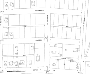
The first edition of the Sanborn Fire Insurance Company map includes only the first two houses on the north side of Pearson Street at the corner of North Clinton Street.
The Walla Walla County Assessor lists the construction date for the house at 621 Pearson Street as 1900. Assessor dates are most often estimates, and 1900 is almost a default date for an old building when more accurate information is unavailable. City of Walla Walla building permits are preserved as far back as mid-September 1907. The Sanborn Fire Insurance Map in its first edition of 1905 does not show any structure at 621 Pearson, the only two houses on that side of Block 2 being the first two lots on the corner of North Clinton Street.
Periodically, updates were made to the Sanborn maps by pasting footprints of new buildings that had been constructed onto the preceding map. The first update to the 1905 map was made in July 1909, by which time the house at 621 Pearson can be seen. An even later pasted-over update to the Sanborn map shows a garage on the alley, marked “Auto” behind 621 Pearson.
As noted above, on 10/19/1904, Bessie and George Savage sold Lot 11 of Block 2 in Isaacs’ Third Addition to Lora
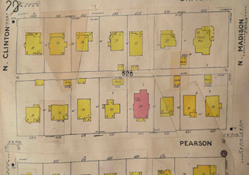
A later update to the Sanborn map shows not only 621 Pearson Street, but also a garage, added later, visible near the number 526.
Rees Compton for $600, the price indicating it was an undeveloped lot. Paul and Lora Rees Compton sold the lot to Bert Driver on 5/4/1907. The city directory for 1908 shows Driver residing at 621 Pearson. The directory for 1907 indicates that Driver resided at 717 Pearson Street and was manager of the Walla Walla Stationery Company. It should be noted that the 1907 directory was filed with the Librarian of Congress in Washington, D.C. in 1906. On 4/3/1909, Bert O. and Maria Driver sold Lot 11 to George Koechig for $4,000, a price that indicates that a house had been built on the lot, and indeed the city directory for 1909-10 indicates that Koechig was residing at 621 Pearson. Koechig was a physician, with an office in the Drumheller Building on Alder Street at 2nd. He was later the County Health Officer. This sale was not filed until 6/23/1919. The sale from Driver to Koechig was listed as Indenture, a legal agreement or a contract, and this may be why it was not filed for ten years, until Koechig had fulfilled the terms of the agreement or contract.
A double-check of building permits by address and by property owner from mid-September 1907, which is as far back as permits are preserved, up to the first revision of the Sanborn map in 1909 that clearly shows a dwelling on Lot 11, reveals no building permit issued to construct 621 Pearson Street. Based on the absence of a permit for 621 Pearson Street, the fact that Bert Driver was listed in the 1908 directory as residing at that address, it is probable that Driver commenced construction of the house prior to mid-September 1907. Thus, a build date of 1907, perhaps overlapping into 1908, is likely for 621 Pearson Street.
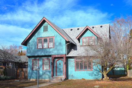
The house, from its copious use of plain shingles, could be described as shingle style or craftsman. It is a two-story house with a prominent side gable and a large projecting front gable on the left side. Windows are double-hung, in some cases with mullioned panes in both sections, others with muntins only in the top half, and in yet others single panes in both top and bottom halves. The house is essentially lacking in ornamentation save for one outstanding feature, the Tudor Gothic front door set off by a heavy timber surround. The house is a contributing member to this block of historic residences.
Resources
- TitleOne, formerly Pioneer Title & Escrow
- Whitman College Archives
- Bureau of Land Management
- Sanborn Fire Insurance maps, 1905 and later updates Walla Walla City Directories, various years
- Lyman, Prof. William D., Lyman’s History of Old Walla Walla County, Embracing Walla Walla, Columbia, Garfield and Asotin Counties, Vol. 2, S. J. Clarke Publishing Company, Chicago,1918


