History of 601 Howard Street, Walla Walla, WA
Legal Description
Tract A of Short Plat filed October 3, 1985, in Volume 2 at page 79 under Auditor’s File No. 8506896, records of Walla Walla County, Washington.
ALSO, the West 44.74 feet of Tract B of Short Plat filed October 3, 1985, in Volume 2 at page 79 under Auditor’s File No. 8506896, records of Walla Walla County, Washington.
Title and Occupant History
Washington Territory was created in 1853. In 1854, the new territorial legislature created Walla Walla County, which stretched from the crest of the Cascade Mountains to the crest of the Rocky Mountains in the present states of Washington, Idaho, and Montana. In 1855, Isaac Stevens, governor of Washington Territory, held a council on the banks of Mill Creek at the present site of Walla Walla with representatives of regional Native tribes to purchase land from them. The Yakama, Cayuse, and Walla Wallas were dissatisfied with the treaties and the intrusion by whites into their lands before the treaties’ ratification, and war followed. Missionaries, former French-Canadian employees of the Hudson’s Bay Company trading post at Wallula, and soldiers at the military Fort Walla Walla were the primary European occupants of the area prior to 1859, when the treaties were finally ratified and the land was opened for settlement. The transfer of ownership occurred by virtue of a treaty signed on June 9, 1855, in Walla Walla and ratified on March 8, 1859, by President James Buchanan, in which all of the land in the Walla Walla area was acquired from the Cayuse and Walla Walla tribes.
The Town of Walla Walla was originally laid out by County Surveyor Hamet Hubbard Case in 1859. In 1862, Walla Walla was formally incorporated as a city one-quarter mile square. Its eastern side was centered on the point where Main Street crossed Mill Creek (at roughly the point it does now). The original plat was lost, probably in the fire of 1865. Thus, the earliest plat on file is one made by W.W. Johnson, City Surveyor, in July, 1865, that claims to have made corrections to Case’s survey. Johnson’s survey was made the Official Plat of the City of Walla Walla on September 25, 1866, and was filed and recorded July 5, 1867.
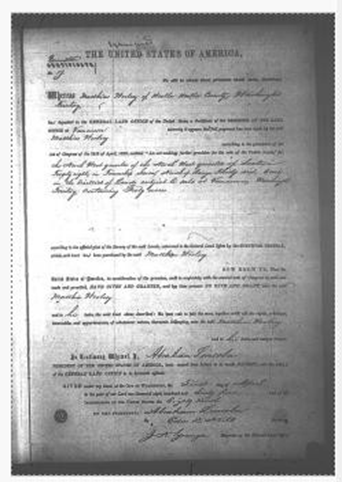
U.S. Land Patent for 40 acres issued to Matthias Woolsey on April 1, 1865.
601 Howard Street is situated on a parcel of 40 acres granted to Matthias Woolsey by U.S. Land Patent on April 1, 1865. A land patent is the original transfer of land from the U.S. Government to a private land owner. Matthias Woolsey’s patent was issued by the Abraham Lincoln administration 14 days before Abraham Lincoln was assassinated. Woolsey’s acquisition was The North West quarter of the North West quarter of Section Twenty-eight, in Township Seven, North of Range Thirty six, East.
John and Viretta Bryant, husband and wife, acquired the land awarded to Matthias Woolsey by patent in 1865. The Bryants held extensive property in the vicinity of what is now Bryant Avenue and Howard Street. Although the chain of title from Woolsey to Bryant is not clearly indexed, Bryants’ property acquisition began before 1880. The Bryants platted Bryant’s Addition south of Pleasant Street in September 1880. The 1881 Walla Walla City Directory lists John Bryant as a street contractor residing in Bryant’s addition.
The first transaction indexed in Walla Walla County real property records relative to 601 Howard Street is the lease that follows.
3/29/1886, Lease, Mrs. Viretta Bryant, Lessor, to “Lee Wah and Sam (two Chinamen),” Lessees. Beginning at a point on the North side of Pleasant Street in Bryant’s addition to the City of Walla Walla distant eighty-five feet East from the North East corner of Howard and Pleasant Streets, running thence North one hundred and forty feet, thence East one hundred and sixty five feet; thence North eighty feet, thence West to the East line of said Howard Street, thence Northerly along East line of Howard Street to the stable lot, thence East the length of the stable lot, thence North the width of the stable lot, thence East to the West line of Division street, thence South along the West line of said Division Street to the North side of said Pleasant Street, thence West along the North line of said Pleasant Street to the place of beginning. The term of the lease was five years. Rent for each of the first two years was One Hundred Dollars gold coin of the United States; and for each of the next three years, One Hundred Ten Dollars. The lessees were Chinese produce farmers, among many to whom the Bryants leased portions of their land holdings.
5/05/1898, Indenture, John Bryant and Viretta Bryant, husband and wife, grant, bargain, sell and convey to J.K. Wilson for $1,385 in gold coin the land that became 601 Howard Street plus other land: Beginning at a point on the West line of Section 28, Township 7 North, Range 36 EWM 264 feet South of the South line of Whitman Street, running thence South on said Section line 133 feet; thence East to a point 105 feet West of the West line of land sold by the parties of the first part hereto to Daniel Stewart January 9, 1897; thence South 237.5 feet to Pleasant Street in Bryants Addition to the City of Walla Walla, thence East along the North line of Pleasant Street 105 feet thence north 370.5 feet; thence West to the point of beginning. Also Blocks or Lots “H” and “J” of Roberts Addition to the City of Walla Walla, Washington.
2/02/1906, Agreement for Deed. J.K. Wilson agrees to sell to Gabriel Sykes a 215-foot x 75-foot parcel including the personal property described in the contract: Commencing at a point 427 5/10 feet South and 30 feet East of the North-west corner of section 28 Township 7 North, Range 36 E.W. Meridian; thence
East 215 feet, more or less; thence North 75 feet, more or less; thence West 215 feet, more or less; thence
South 75 feet more or less to the point of beginning, with all improvements thereon, including a milch [sic] cow and a quantity of house-hold furniture in the City of Walla Walla. This is the parcel containing the 601 Howard residence, configured very closely to today’s lot definition. The contract purchase price was $5,000, payable $500 at the time of signing and $100 quarterly thereafter until paid in full, together with interest at the rate of 7% per annum on the unpaid balance.
Prior to coming to Walla Walla, Gabriel Sykes pastored a Methodist Episcopal Church in Pullman,
Washington. In Walla Walla, he served as District Superintendent of the ME Church. Methodist Episcopal was a vigorous, growing institution in the early 1900s, and by 1910 there were six Methodist Episcopal Churches in Walla Walla. When Sykes left Walla Walla, he continued to pastor ME Churches around the northwest.
1/28/1909, Quit Claim Deed. J.K. Wilson, for $100 and other consideration, sells and quit claims “unto Amy F. Wilson, my wife”, the 215’ x 75’ parcel “with all improvements thereon, including a milch [sic] cow and a quantity of household furniture.” This was a transfer of the seller’s interest in the sale contract to Sykes and appears to be made in consideration of a divorce settlement.
1/04/1911, Indenture. Amy F. Wilson, unmarried, in her own right and as sole owner of the lands therein described grants, bargains, and sells to Gabriel Sykes the 215’ x 75’ parcel, for $5,000. This was a fulfillment deed indicating Sykes had paid off the contract.
4/20/1912, Indenture. In a transaction identical to the above except for date, Amy F. Wilson again conveys to Gabriel Sykes the 215’ x 75’ parcel for $5,000 in what appears to be a fulfillment deed.
Between the 1911 and 1912 Indentures granting land from Amy Wilson to Gabriel Sykes, and the year 1919, the land reverted to Amy F. Wilson. The record is silent as to how or why this reversion or conveyance took place, but the next recorded document in 1919 evidences Amy F. Wilson again selling 601 Howard Street.
8/20/1919, Warranty Deed. Amy F. Wilson, unmarried, in her own right and as sole owner of the lands hereinafter described, to Francis M. Lowden and Elsie Lowden, his wife. Commencing at a point 427.5 feet south and 30 feet east of the Northwest corner of Section twenty-eight (28) in Township Seven (7) North, of Range thirty-six (36) E.W.M.; thence east 215 feet; thence north 82 feet; thence west 215 feet; thence south 82 feet to the point of beginning. Sale price $3,500.
Francis Martin Lowden, Jr., known as Frank, was the son of Francis Martin Lowden, who had come west with a wagon train in 1849 as a teenager. Lowden Sr. engaged in various businesses around the Western U.S., finally purchasing 160 homestead acres on the Walla Walla River in 1869 and establishing a cattle ranch. The small town of Lowden on Highway 12 west of Walla Walla was named for Francis Martin Lowden, Sr. Frank Lowden (Jr.), after working on his father’s ranch, became the manager of the Walla Walla Meat & Cold Storage Company, the oldest firm of its kind in the state. Frank Jr. worked with that firm until his death. The Lowdens had three children while living at 601 Howard Street: John, Lillian, and Frances. Frank Lowden and Elsie Lowden are both buried in Walla Walla at Mountain View Cemetery. 601 Howard is a featured home in Walla Walla – Her Historic Homes, Vol III. See References at the end of this document.
11/13/1969, Inventory and Appraisement, Walla Walla County Superior Court Case 56646. Conveyance of interest in 601 Howard Street from the Estate of Elsie Lowden, the last-surviving spouse of the Francis and Elsie Lowden marriage, to Frances Mattie (Lowden) Borgens, one of the Lowden children. In 1970, Frances Borgens was a teacher at Pioneer Junior High School. George Borgens is listed as an employee of the U.S. Corps of Engineers and a cattle rancher.
7/29/1970, Quit Claim Deed. Frances Mattie Borgens and George Borgens, her husband, to Lillian Banks, whose husband is Harold Banks. The legal description was corrected by a Correction Quit Claim Deed filed 12/22/1970, next entry.
12/22/1970, Correction Quit Claim Deed. Frances Mattie Borgens and George Borgens, her husband, to Lillian Banks, whose husband is Harold Banks, as her sole and separate property. Beginning at a point in the East line of Howard Street in the City of Walla Walla, Washington which point is 427.5 feet South and 30 feet East of the Northwest corner of Section 28 in Township 7 North, Range 36, East of the Willamette Meridian, and running thence East 215 feet; thence North 82 feet; thence West 215 feet to said East line of Howard Street; thence South, along said East line 82 feet to the point of beginning; Also, beginning at the Northwest corner of Section 28 in Township 7 North, of Range 36 East of the Willamette Meridian, and running thence South on the West line of said Section 28 a distance of 427.5 feet; thence East, parallel to the North line of said Section 28, a distance of 215 feet to a point which is the true point of beginning for this description. From the true point of beginning so ascertained run West 30 feet; thence South, parallel to the West line of said Section 28, a distance of 97.5 feet; thence East 30 feet; thence North 97.5 feet to the point of beginning. In 1970, Lillian Banks resided at 601 Howard and is listed as a private secretary at Baker Boyer Bank. No occupation is given for Harold Banks in the 1970 City Directory.
Frances Borgens and Lillian Banks were daughters of Frank and Elsie Lowden. Thus, 601 Howard was held by Lowden family members from the purchase by Francis and Elsie Lowden in 1919 to the sale by Lillian Banks in 1986.
10/03/1985, Short Plat No. 8507138. This Short Plat, performed at the request of Lillian Banks, defines the 140.16-foot by 82-foot parcel as Tract A, and the 74.74-foot by 82-foot parcel as Tract B.
3/27/1986, Statutory Warranty Deed. Lillian Banks, whose husband is Harold Banks, as her sole and separate property, to Michael E. Spring and Ann H. Spring, husband and wife. Beginning at the Northwest corner of section 28, Township 7 North, Range 36 East of the Willamette Meridian, and running thence South 0°00’00” West, 427.50 feet; thence North 89°49’00” East, 30.00 feet to a point in the East line of Howard Street and the true point of beginning for this description; thence continue North 89°49’00” East, 140.26 feet; thence North 0°00’00” East, parallel to the said East line of Howard Street, 82.00 feet to a point in the South line of Craig Street; thence South 89°49’00” West, along said South line, 140.26 feet to a point in the East line of said Howard Street; thence South 0°00’00” West, along said East line, 82.00 feet to the true point of beginning. Michael Spring was a firefighter with the Walla Walla Fire Department.
12/16/1991, Contract for Sale. Stephen L. Walters and Michele R. Walters, husband and wife (owners of adjacent property) agree to sell to Michael E. Spring and Ann H. Spring, husband and wife, the West 44.74 feet of Tract B. Beginning at the northwest corner of Section 28, Township 7 north, Rage 36 east of the Willamette Meridian, and running thence south 0 00’ 00” west, 427.50 feet; thence north 89 49’0” east, 170.26’ to the TURN [sic] POINT OF BEGINNING for this description; thence continuing north 89 49’0” east, 74.74’; thence north 0 0’ 00” east, 82.00’ to a point in the south line of Craig Street; thence south 89 49’00” west, along said south line, 74.74’; thence south 0 0’ 00” west, 82.00’ to the point of beginning. Being Tract B as designated on Short Plat filed October 3rd, 1985 in volume 2, page 79 of Short Plats, under auditor’s file no 8506896, records of Walla Walla County, Washington.
10/18/1995, Statutory Warranty Fulfillment Deed. Stephen L. Walters and Michele R. Walters, husband and wife, to Michael E. Spring and Ann H. Spring, husband and wife. This conveyance indicates that the Springs had fulfilled the terms of the purchase contract for the West 44.74 feet of Tract B. This sale created an informal “lot” of Tract A and the West 44.74 feet of Tract B, which remains the configuration of the property today although each tract is listed as a separate Assessor’s parcel number.
10/30/1997, Statutory Warranty Deed. Michael E. Spring and Ann H. Spring, husband and wife, to David A. Dyer and Loriann R. Dyer, husband and wife. Tract A and the West 44.74 feet of Tract B, Short Plat 8506896 filed 10/03/1985.
3/31/2003, Statutory Warranty Deed. David A. Dyer and Loriann R. Dyer, husband and wife, to Thomas G. Bolduc and Jennifer L. Bolduc, husband and wife. Tract A and the West 44.74 feet of Tract B, Short Plat 8506896 filed 10/03/1985.
6/22/2015, Statutory Warranty Deed. Thomas G. Bolduc and Jennifer L. Bolduc, husband and wife, to Paul Gregory Bowen and Samantha Kate Bowen, husband and wife. Tract A and the West 44.74 feet of Tract B, Short Plat 8506896 filed 10/03/1985.
10/14/2022, Statutory Warranty Deed. Paul Gregory Bowen and Samantha Kate Bowen, husband and wife, to Mark H. Bennett and Charlene R. Bennett. Tract A and the West 44.74 feet of Tract B, Short Plat 8506896 filed 10/03/1985.
Construction of Building
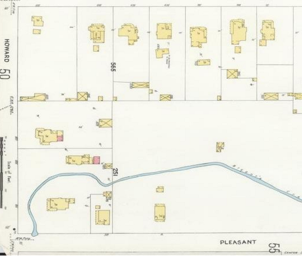
1905 Sanborn Fire Insurance Map showing 601 Howard to the left of center. The wraparound porch is visible in the drawing; the pink portion at the back of the house indicates a small area of brick construction. The outbuilding at the back of the property (yellow with an “x”) may be the abode of the milk cow.
The Walla Walla County Assessor lists a 1910 construction date for the house at 601 Howard Street. Assessor’s construction dates are usually estimates in houses of this age. 601 Howard was clearly constructed earlier than 1910.
City of Walla Walla building permits are preserved only as far back as mid-September, 1907. The 1905
Sanborn Fire Insurance Map depicts the residence at 601 Howard Street. The 1904 City Directory lists John K. Wilson, farmer, residing at 601 Howard Street. No 1903 City Directory is extant; and the 1902 and earlier directories list John K. Wilson at other addresses including 420 Catherine. It is a reasonable estimate that John K. Wilson, who had purchased the larger parcel in 1898, built the home in approximately 1903. He appears to have inhabited the home himself before selling to Gabriel Sykes on contract in 1906.
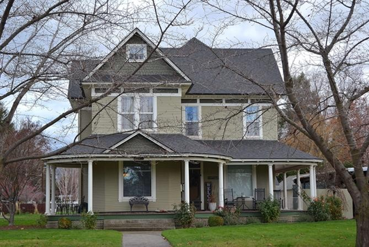
601 Howard Street is best described as a late version of the Queen Anne style that was popular beginning in the 1870s and was still manifesting in buildings in the West after it had declined in the East. This was typical during the 19th century and even early 20th century when the West was typically late in adapting to the latest architectural trends. The house at 601 Howard has many Queen Anne characteristics – irregular massing, steeply pitched gabled roof that includes a front gable, and a spacious, wrap-around porch covered and attached to rather than incorporated into the house. However, by the time this house was built, the abundance of lathe-turned and other types of ornamentation that characterized Queen Anne during the late 19th century had largely diminished. (See for example the Ritz mansion on Plaza Way.) This house, with its clapboard siding and fish scale shingles on the attic gables, is a well-maintained early twentieth-century house and a contributing member of this historic neighborhood.
Resources
- TitleOne, formerly Pioneer Title & Escrow
- Whitman College Archives
- Bureau of Land Management
- Sanborn Fire Insurance map, 1905, Library of Congress
- Walla Walla City Directories, various years
- Pullman Herald Newspaper -October 24, 1903
- Andres, Penny Walla Walla – Her Historic Homes, Volume III, Fort Walla Walla Historical Society, 1998


