History of 341 East Alder Street, Walla Walla, WA
Legal Description
Lot 4 in Block 1 of Boyer Grove Addition to the City of Walla Walla, Washington, according to the official plat thereof of record in the office of the Auditor of of Walla Walla County, in Book C of Plats at Page 13.
Title and Occupant History
Washington Territory was created in 1853. In 1854, the new territorial legislature created Walla Walla County, which stretched from the crest of the Cascade Mountains to the crest of the Rocky Mountains in the present states of Washington, Idaho and Montana. In 1855, Isaac Stevens, governor of Washington Territory, held a council on the banks of Mill Creek at the present site of Walla Walla with representatives of regional Indian tribes to purchase land from them. The Yakamas, Cayuses and Walla Wallas were dissatisfied with the treaties and the intrusion by whites into their lands before the treaties’ ratification, and war followed. Missionaries, former French-Canadian employees of the Hudson Bay Company trading post at Wallula, and soldiers at the military Fort Walla Walla were the primary European occupants of the area prior to 1859, when the treaties were finally ratified and the land was opened for settlement. The transfer of ownership occurred by virtue of a treaty signed on June 9, 1855 in Walla Walla and ratified on March 8, 1859 by President James Buchanan, in which all of the land in the Walla Walla area was acquired from the Cayuse and Walla Walla Indian tribes.
The town of Walla Walla was originally laid out by County Surveyor H. H. Case in 1859, prior to its formal incorporation as a city in 1862, as a one-quarter mile square with its eastern side centered on the point where Main Street crossed Mill Creek (at roughly the point where it does now). Case’s plat was filed and recorded July 5, 1867 in Book A of Plats, Page 1. The City of Walla Walla received a Trustee Town site from the U. S. Government that consisted of 80 acres, issued on July 20, 1869 by the Vancouver, W. T. District Land Office.
To this original area additional parcels were annexed from time to time, often bearing the name of the landowner of record at the time the additions were created. The first recorded transaction for the land where the house at 341 East Alder Street stands was by an Act of Congress, approved March 3, 1855 granting Bounty Land to certain officers and soldiers. A General Land Office Warrant No. 88771 for 160 acres was granted to Cornelius Kelly, sergeant, Company F, 3rd Regiment, United States Artillery, California Indian War. Sgt. Kelly sold the land to Andrew J. Cain on September 10, 1862.
2/21/1865, Deed, including this property, A. J. and Emma R. Cain, grantors; D. S. Baker, grantee, $3,500.
10/17/1871, Deed, including this property, Andrew J. and Emma R. Cain, grantors; Dorsey S. Baker, grantee, $1.
1/29/1885, Quit Claim Deed including this property, John F. and Sarah Boyer, grantors; Dorsey S. Baker, grantee, “the S.W. ¼ of the N.E. ¼ of Section twenty Township seven North, of Range thirty-six East of the Willamette Meridian…excepting riparian rights and privileges…to the waters of Mill Creek…” $1. This deed was part of a settlement between Baker and the Boyers covering several real estate transactions on behalf of Baker and Boyer in which title was taken only by Baker, but regarding which the partners later distributed the property equitably between themselves.
2/10/1899, Plat of Boyer Grove Addition filed by Miles C. Moore, Henry Clay Baker and Walla Walla Willie Baker, Executors of the estate of Dorsey S. Baker, and Eugene H. and John E. Boyer, Executors of the estate of J. F. and Sarah Boyer.
4/13/1900, Warranty Deed against grantor, Miles C. Moore, Henry Clay Baker, Walla Walla Willie Baker, as Executors of the last Will and Testament of Dorsey S. Baker, deceased, grantors; Baker & Baker, a Corporation of the County of Walla Walla, grantee, Lot 4 in Block 1 of Boyer Grove Addition plus numerous other properties, $1.
1/7/1910, Deed, Baker & Baker, grantor; C. P Gammon, grantee, Lot 4, Block 1, $1,100. This represents the first sale limited to this lot. Clarence Gammon (1870-1943), born in Missouri, moved to Walla Walla from Pomeroy in 1902. He was a physician with offices first in the Paine Building and later in the Denny Building. In 1904, he was Health Officer for the City of Walla Walla. He also served on the State Board of Health and Vital Statistics. By 1920 he and Mrs. Gammon had moved to Tacoma (see following Warranty Deed).
7/28/1921, Warranty Deed, Clarence P. and Mary Helm Gamon, grantors; F. E. and Priscilla Aldrich, grantees, $3,250.
9/2/1921, Warranty Deed, F. E. and Priscilla Aldrich, grantors; Edward H. Bradbury (1876-1958), grantee, $3,500. Mr. Bradbury was a farmer with residence in Palouse, Whitman County. Neither Edward Bradbury nor Ella, his wife, had listings in Walla Walla city directories.
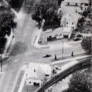
An aerial photo from the 1940s with the added service bay visible on the right facing Park Street.
5/16/1927, Lease, E. H. and Ella Bradbury, lessors; B. F. Owsley, lessee, “for a period of five years beginning 4/15/1925…it is agreed that the dwelling house now thereon is to remain..that second party is to construct a service station on the Southeasterly corner of said premises…of his own design…” Rental to be $40/month for the first year, $50/month for the second, $60/month for the third, $70/month for the fourth, and $80/month for the fifth and final year of the lease. B. F. Owsley had moved from Colfax to Walla Walla in 1912 to assume a position as traveling agent for the Kerr-Gifford Company. In August 1923, his conviction for Theft (State of Washington vs. B. F. Owsley, 1922) was upheld by the Appellate Court; the case involved theft of wheat.
9/12/1927, Lease, Charles O. and Bertha M. Whitney, lessors; The Texas Company, 17 Battery Place, New York City, lessee, 75’ on Alder Street, the entire length of Lot 4, Block 1 on Park Street, 22’ on the alley, a three-year lease @ $35/month to The Texas Company. Charles O. Whitney had been a farmer who, at this point in his life, assumed the position of proprietor/manager of the service station that abutted his house. Bertha Whitney was an active member of Pioneer Methodist Church and the Women’s Christian Temperance Union, hosting WCTU and Pioneer Methodist women’s groups in her home.
11/3/1927, Warranty Deed, Edward H. and Ella Nora Bradbury, grantors; Charles O. Whitney, grantee, all of Lot 4, subject to a mortgage of $2,000 @7% interest per annum, $5,500.
9/25/1930, Extension of Lease, Charles O. and Bertha M. Whitney, grantors; The Texas Company, Inc. under the laws of the State of California, a two-year extension @ $35/month.
9/5/1931, Cancellation of Lease Agreement, The Texas Company to Charles O. Whitney, to terminate the lease as of 7/10/1931.
9/5/1931, Lease, Charles O. and Bertha M. Whitney, lessors; The Texas Company, 929 South Broadway, Los Angeles, to lease for ten years the balance of property comprising Lot 4, Block 1 at a rate of 1¢ for every gallon of gas sold during the month, payable by the 10th of each month.
10/3/1935, Cancellation of Lease, The Texas Company and Charles O. Whitney, et ux, to cancel all of Lot 4 except the “Westerly 40 feet on Alder comprising the residence property.”
11/17/1937, Bill of Sale, Charles O. Whitney et ux to True’s Oil Company, the service station on Lot 4, Block 1 “excepting Westerly 40 feet,” $10.
11/22/1937, Warranty Deed, Charles O. and Bertha M. Whitney, grantors; True’s Oil Company, a Washington Corporation, grantee, Lot 4, Block 1 “excepting the West 40 feet thereof,” $10.
6/18/1954, Statutory Warranty Deed, Charles O. Whitney, a widower, as Executor under the last Will and Testament of Bertha M. Whitney, deceased, grantor; Robert S. and Dorothy H. Thorne, grantees, the “Westerly 40’ of Lot 4,” $13,000.
12/31/1965, Quit Claim Deed, True’s Oil Company, a Corporation existing under the laws of the State of Washington, grantor; The American Oil Company, a Corporation existing under the laws of the State of Maryland, grantee, Lot 4, Block 1…except the West Forty (40) feet thereof, $10.
4/12/1971, Statutory Warranty Deed, Robert S. and Dorothy H. Thorne, grantors; John J. and Joan J. Daniels, grantees, $10 and other valuable consideration.
5/12/1973, Statutory Warranty Deed, John J. and Joan J. Daniels, grantors; Lee Krika, a single woman, grantee, $10 and other valuable consideration.
9/18/1975, Quit Claim Deed, City of Walla Walla, a Municipal Corporation, grantor; Lee A. Krika, a single woman, “Lot 4, in Block 1 of Boyer Grove Addition to the City of Walla Walla, Washington according to the official plat thereof of record in the office of the Auditor of the County of Walla Walla in Book C of Plats at Page 133, EXCEPT the West 40 feet thereof,” $10 and other valuable consideration.
11/18/1975, Surveyor’s Certificate, Ronald A. Munna, surveyor, for Mrs. Lee Krika.
5/22/1992, Real Estate Conract, Lee A. Krika, as her separate estate, seller; Timothy J. and Jeanette G. Richmond, buyers, $105,000.
11/26/1993, Statutory Warranty Deed, Lee A. Krika, as her separate estate, grantor; Timothy J. and Jeanette G. Richmond, grantees, $10 and other valuable consideration.
12/14/2007, Statutory Warranty Deed, Tim and Jeanie Richmond, grantors; Julie A. Carlson-Ovens, a married person as her sole and separate property, $290,000.
3/26/2014, Quit Claim Deed, Bryan Michael Spencer Ovens, grantor; Julie Ann Brown, grantee.
10/26/2016, Statutory Warranty Deed, Julie Ann Brown, grantor; Curtis L. and Lisa D. Esteb, grantees.
Construction of Building
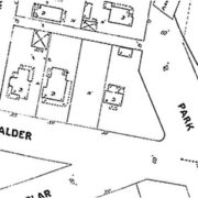
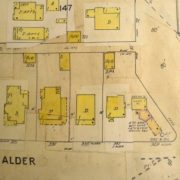
Figure 1. 1905 Sanborn Fire Map without subsequent updates/ alterations.
Determining a precise timeline for the house at 341 East Alder Street has proven challenging. Dr. Clarence Gammon, the first owner who lived there, purchased Lot 4 of Block one of Boyer Grove Addition on 1/7/1910. However, he is first listed as living there in the 1904 City Directory; no directory was published in 1903, and in 1902 he was residing at 417 East Rose Street. The first edition of the 1905 Sanborn Fire Map that bears no later alterations or additions shows clearly a house on the lot with a smaller building at the alley (see Figure 1). Therefore, it is assumed that Dr. and Mrs. Gammon purchased the property by real estate contract from Baker & Baker, probably in 1903, and the deed of 1/7/1910 was conveyed upon satisfaction of the contract.
The first permit issued for any work on this lot is dated 6/19/1928, when then-owner Charles O. Whitney was issued Permit 5189 for a fee of $1.50 to “remodel” the house on the site, estimated cost to be $400. He listed himself as contractor. This was a sizable amount in 1928; nonetheless it would appear to be a modest amount to transform the smaller house into the more substantial house that is currently there. (See Figure 2 that is an update to the original 1905 Sanborn Fire Map and shows a house with a larger footprint than the house depicted on the original 1905 Sanborn map.) Mr. Whitney paid fifty cents on 9/17/1928 for a permit to construct a garage, estimated to cost $150.
Figure 2. 1905 Sanborn Fire Map updated, showing a larger footprint for the house and the service station. Note the later addition of a bay to the east of the service station, probably used for servicing cars.
The County Assessor’s estimated date of construction is 1920. This would appear to be a reasonable guess, but no building permit could be located anywhere around 1920. It is probable, but unfortunately inconclusive, that the permit obtained by Mr. Whitney is 1928 was to enlarge the house already existing on the property and convert it into the Dutch Colonial style it presents to date. The estimated cost of $400 given by Mr. Whitney was just that – an estimate – and the job may well have come in considerably higher.
The best guess for construction of 341 East Alder Street is 1903-04 with alterations and additions in 1928.
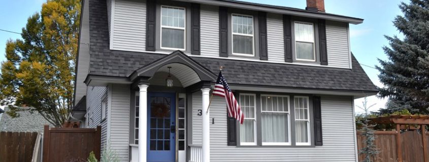
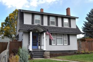
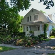
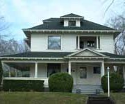
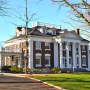
341 East Alder Street can be classified as an Eclectic House: Colonial Revival, subsection Dutch Colonial. What sets it apart, of course, is the distinctive gambrel roof. The gambrels are steeply pitched, and the continuous shed dormers on front and back allow full headroom in the second story. The front door is at the left, giving the façade a more interesting asymmetrical appearance; in Dutch Colonial houses the entrance was more often in the middle. The small porch is capped with a gabled extension supported by two simple round columns. Sidelights on either side of the front door allow additional light to the entryway. Windows in the house are double hung, multi-paned top half, single pane bottom half. The north dining room window is particularly interesting with its rounded corners at the top.
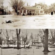
Two views of the Triangle Service station and 341 East Alder Street taken during the Mill Creek flood of March 31, 1931. Top: Jo Winn photo, courtesy Joe Drazan; Bottom: Whitman Archives.
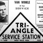
On 4/14/1925, B. F. Owsley was granted Building Permit 4325, for a fee of $1.50, to “construct a gasoline station” on the east portion of Lot 4, Block 1, Boyer Grove Addition, at the time owned by the Bradburys. $1,000 was the estimated cost of construction. W. H. Huntington was listed as contractor. The first listing for a service station at 343 East Alder Street is in the 1926-27 city directory, with the name Owsley’s Service Station. No directory exists for 1928; in the 1929-30 directory it is listed by its more apt name, Triangle Service Station, C. O. Whitney, proprietor. It retained the Triangle name for most of the remaining years of its existence, dispensing Texaco products. No attempt was made to locate a building permit, but by the 1940s a bay, presumably for servicing cars, had been added to the north (Park Street) side of the station.
(On 5/4/1982 a building permit was issued to owner Lee Krika to extend the dining room.)
If it is difficult to determine a precise date of construction for the house, its next-door neighbor of some four decades – a gas station – is easier to date with precision. Although the subject of this report is the house, so interwoven with the house was the gas station – not to mention an abundance of photographs of it that are available, most taken during the flooding of Mill Creek on March 31, 1931 – that it merits inclusion in this report.
A 1947 advertisement for the Triangle Service Station. Courtesy Joe Drazan.
Mr. Whitney appears to have retired as manager of the Triangle Service Station by the late 1930s. In 1938, Alton Thompson assumed the position, a rather quirky career change for one who formerly was a Deputy County Treasurer. By 1946, the name had been changed to Jarvis Service Station, Bernard Jarvis, operator. However, in the 1949-50 city directory the name Triangle Service Station reappears. At some point the address was changed from 434 to 435 East Alder Street. Its last year of operation as a service station appears to have been 1963; it was listed in city directories as “vacant gas station” through 1968. No demolition permit could be found, but it was probably razed shortly after 1968.
References
- Whitman Archives
- Sanborn Fire Maps (various)
- Walla Walla City Directories (various)
- Bygone Walla Walla blog
- Bennett, Robert A., Walla Walla: A Nice Place To Raise A Family, 1920-1949, Pioneer Press Books, 1988
- Official Registry and Directory of Physicians and Surgeons In the States of California, Washington and Oregon, November 1905
- Union Civil War Veterans and Widows – Washington State Senate
- Journal of the 10th Legislature of the State of Washington, Olympia, 1907
- The Colfax Gazette, February 16, 1912
- Public Utilities Report, Rochester, NY, 1921
- City of Walla Walla Development Services
- Walla County Assessor Walla Walla Union-Bulletin, various dates, 1945-47

