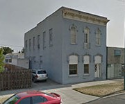
History of 228 East Poplar Street – Walla Walla, WA
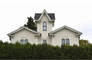
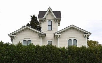
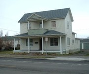
The current peek-a-boo photo of the former Ward residence, currently The Wesley, as seen from the Walla Walla Public Library across Poplar Street.
Abbreviated Legal Description
Unnumbered Block – Roberts’ Tax 12
Full Legal Description
Beginning at a point where the easterly line of Catherine Street, if produced, intersects the southerly line of Poplar Street, in A. B. Roberts’ Block of Roberts’ Addition to the City of Walla Walla, running thence Easterly at right angles to said easterly line of Catherine Street 80 feet; thence at right angles southerly 150 feet; thence at right angles westerly 80 feet; thence at right angles northerly 150 feet, to the point of beginning.
Title and Occupant History
Washington Territory was created in 1853. In 1854, the new territorial legislature created Walla Walla County, which stretched from the crest of the Cascade Mountains to the crest of the Rocky Mountains in the present states of Washington, Idaho and Montana. In 1855, Isaac Stevens, governor of Washington Territory, held a council on the banks of Mill Creek at the present site of Walla Walla with representatives of regional Indian tribes to purchase land from them. The Yakamas, Cayuses and Walla Wallas were dissatisfied with the treaties and the intrusion by whites into their lands before the treaties’ ratification, and war followed. Missionaries, former French-Canadian employees of the Hudson Bay Company trading post at Wallula, and soldiers at the military Fort Walla Walla were the primary European occupants of the area prior to 1859, when the treaties were finally ratified and the land was opened for settlement. The transfer of ownership occurred by virtue of a treaty signed on June 9, 1855 in Walla Walla and ratified on March 8, 1859 by President James Buchanan, in which all of the land in the Walla Walla area was acquired from the Cayuse and Walla Walla Indian tribes.
The town of Walla Walla was originally laid out by County Surveyor Hamet Hubbard Case in 1859, prior to its formal incorporation as a city in 1862, as a one-quarter mile square with its eastern side centered on the point where Main Street crossed Mill Creek (at roughly the point where it does now). The original plat was lost, probably in the fire of 1865. Thus, the earliest plat on file is one made by W. W. Johnson, City Surveyor, in July 1865 that claims to have made corrections to Case’s survey. Johnson’s survey was made the official plat of the City of Walla Walla on September 25, 1866, was filed and recorded July 5, 1867.
A.B. (Alvin Brown) Roberts was born May 17, 1832 in Knox Township, Jefferson County, Ohio. He arrived in Oregon Territory in 1853 and settled in Portland where he established the stone cutting firm of Roberts and Hartle. He served in Company A, Multnomah County, First Regiment from October 13 to December 19, 1855 in what was known as the Yakima War. He fought in what became known as the Battle of Walla Walla from December 7-11, 1855.
After his military service, Roberts went back to marble-cutting in Boise City, Idaho. On September 15, 1858 Roberts married Martha Elizabeth Baxter in Clackamas County, Oregon. (They divorced in 1866.)
A. B. Roberts and Martha left Portland, Oregon in 1859, traveling upriver to The Dalles, and eventually by land on to Wallula, W.T. From there they ventured on to the military Fort Walla Walla, at that time located along what is now East Main Street east of First, where Roberts determined to remain, purchasing property from Tom Hughes near the current northeast corner of South 1st and Alder Street for $250, which amounted to about 160 acres. He constructed a house of canvas and poles about 150 feet south of that corner. He fenced in additional land around his rudimentary house and held it until the small town was surveyed. Roberts was one of 42 men selected to run for city office in 1862 in an effort to curb crime in Walla Walla; it appears he was neither elected nor appointed to office.
Roberts planted what is believed to be the first apple orchard in the valley other than those planted by Marcus and Narcissa Whitman at the Whitman Mission. Roberts sold some of his one-year-old trees for one dollar each and since that proved so profitable, went into the nursery business exclusively. He rose to much prominence in the fruit industry of the territory and state, much of which was centered in Walla Walla at that time. He was also the father of Masonry in Walla Walla and was first the master of the Walla Walla Lodge No.7.
Eventually A. B. and Martha Roberts extended their holdings, including acreage granted by the United States Government under the Homestead Act that ranged from approximately First Street on the west to approximately Howard Street on the east, and from approximately L Street on the south to Alder Street to the north. Platted in 1870, the land was recorded January 20, 1871 as Roberts’ Addition to the City of Walla Walla.
Following legal action against A. B. Roberts, Burrell W. Griffin, Sheriff of Walla Walla County, Washington Territory, gave a Sheriff’s Deed to Amelia E. Ward on 12/17/1873 for the property described below.
All that certain piece or parcel of land marked A. B. Roberts in A. B. Roberts Addition to the City of Walla Walla, the same being bounded as follows: On the Northerly Block No. (2) two, on the Easterly Block No. (3) three, on the South by Park street and the land owned by Lewis McMorris and on the West by the boundary line of said mortgaged premises according to the plat and survey thereof as the same appears of record in the County Auditor’s office, lying and being in the City and County of Walla Walla, Territory of Washington, with all and singular the tenements, hereditaments, rights, privileges and appurtenances to the same belonging or in any way appertaining, $2,400.
6/18/1881, Deed, M. B. and Aurelia [sic] Ward, grantors; William O’Donnell, grantee, the right to lay pipes and take water from a spring for their own family, $3.
1/24/1882, Quit Claim Deed, Sigmund and Rose Schwabacher, grantors; T. R. Tannatt, grantee, numerous parcels in A. B. Roberts’ Addition that are difficult to determine as the block is unnumbered, $250.
2/4/1899, Quit Claim Deed, Amelia E. Ward, a widow, and Augusta Ward Rees, a widow, grantors; The City of Walla Walla, grantee, the same water rights enumerated in the Deed of 6/18/1881, $1.
10/16/1906, Deed, William O’Donnell, et al to Estate of Amelia Ward, deceased, to release to the Estate of Amelia Ward and her daughter, Augusta Ward Rees, all water rights enumerated in the Deed of 6/18/1881.
8/28/1907, Quit Claim Deed, T. R. and Elizabeth Tannant, grantors; Augusta W. Rees, Frank W. Rees, Elma Rees Turner and Lora Rees Compton, grantees, the block marked “A. B. Roberts” in Roberts’ Addition; also Lot 7, Block 2; also that part of Lot 2 not platted into lots, commonly described as the South half of Block 2, $15.
7/2/1920, Quit Claim Deed, Lora Rees Compton, Elma Rees Turner, heirs of Augusta Ward Rees, deceased, grantors; Sarah H. Rees, grantee, all properties in Walla Walla, Grays Harbor and Franklin Counties, WA, $1.
The above deeds and quit claim deeds all pertain to the original parcel that defined Michael B. and Amelia Ward’s initial holdings. Part of the former Ward property on the west eventually included the craftsman house that currently houses the Collection Bureau of Walla Walla at 224 East Poplar Street, and Pioneer United Methodist Church. That to the east includes the stucco house at 238 East Poplar Street that is currently part of The Wesley, and the multiple residence on the southwest corner of East Poplar and South Palouse Streets. At the time the Ward house was constructed Poplar Street did not extend east much beyond the approximate location of what is now South Colville Street. The house as constructed was situated in the middle of what is now East Poplar Street and it faced west toward East Street, a short street that ran south from Poplar and may have connected with Birch Street, but it no longer exists. From old Sanborn Fire Insurance maps, East Street appears to have been slightly east of where South Colville Street is now located. Colville Street formerly terminated at East Main Street; it was not extended south beyond East Main Street until sometime after 1905.
2/3/1922, Warranty Deed, Elma Rees Turner, Lora Rees Compton and Sarah H. Rees, grantors; E. J. Cantonwine, grantee, “Beginning at a point on the Southerly line of Poplar Street in the City of Walla Walla, Washington, as now established, which point is the point of intersection of the Easterly line of Catherine Street in said City with the said Southerly line of Poplar Street, if said Easterly line of Catherine Street were produced in a Northerly direction, and which point is 400 feet Westerly, measured along said Southerly line of Poplar Street from the point of its intersection with the Westerly line of Palouse Street in said City; thence Westerly along the said Southerly line of Poplar Street a distance of 50 feet; thence at right angles Easterly and parallel with said Southerly line of Poplar Street a distance of 80 feet; thence at right angles Northerly a distance of 150 feet to the point of beginning,” $1,800. This deed is the initial sale of the westerly portion of the original Ward property.
7/18/1927, Warranty Deed, Elma Rees Turner, widow of H. H Turner, deceased, and Lora Rees Compton and Paul Compton, her husband, grantors; Sarah H. Rees, a widow, grantee, “Beginning on the South Line of Poplar Street 280 feet West of the West line of Palouse Street in Roberts’ Addition in the City of Walla Walla, and running thence Westerly along said Southerly line of Poplar Street a distance of 40 feet; thence at right angles Southerly 150 feet; thence at right angles Easterly a distance of 40 feet; and thence Northerly to the point of beginning, according to the official plat thereof,” $10.
This deed includes property east of 228 East Poplar Street to South Palouse Street.
11/28/1928, Quit Claim Deed, Ernest J. Cantonwine, grantor, Bessie K. Cantonwine, grantee, same as described in Warranty Deed of 2/3/1922, for love and affection.
5/21/1941, Warrant Deed, P. L. Hawley, Alida Fay Hawley, W. H. Hawley, Catherine Hawley Woodman, Beatrice Hawley Snow, Ta. A. Hawley, Henry H. Hawley and Sara A. Hawley, heirs at law of Sarah Hawley Rees, deceased, grantors; S. D. and Mary M. Truitt, grantees, same as warranty deed of 11/28/1927, $500.
5/21/1941, Quit Claim Deed, Luteola Hawley, a widow, grantor; S. D. and Mary M. Truitt, grantees, same as above warranty deed of 11/28/1927, $1.
12/11/1944, Indenture, Continental Land Company, a Washington corporation, grantor; Frank R. and Nancy Josephine Clifton, grantees, “That certain property known as 228 E. Poplar Street, more particularly described as follows: Beginning
at a point where the easterly line of Catherine Street, if produced, intersects the southerly line of Poplar Street, in A. B. Roberts’ Block of Roberts’ Addition to the City of Walla Walla, running thence Easterly at right angles to said easterly line of Catherine Street 80 feet; thence at right angles southerly 150 feet; thence at right angles westerly 80 feet; thence at right angles northerly 150 feet, to the point of beginning. Together with all and singular tenements, rights, easements, hereditaments, and appurtenances thereunto belonging or in anywise appertaining, excepting, however, taxes, assessments or installments of assessments due or to become due since May 25, 1936.” It is unknown how/when Continental Land Company acquired the land.
1/28/1947, Warranty Deed, Bessie K. Cantonwine, a widow, grantor; Arthur C. and Anna M. Keershaw, grantees, same as described above, $10.
The following documents also relate to 228 East Poplar Street.
3/11/1987, Quit Claim Deed, Joe Lawson Clifton, grantor; Gracie E. Clifton, grantee, for love and affection.
8/11/1989, Deed of Personal Representative, Roger F. Clifton, personal representative of the Estate of Gracie E. Clifton, deceased, grantor; Roger F., Caryl J. and Daryl F. Clifton in their separate rights, 228 East Poplar Street and 1150 West Cherry Street. Caryl Clifton owned Clifton Automotive at 220½ Alder Street. He did not reside at 228 East Poplar, and had a residential address of 123 Reser Road.
3/14/2008, Land Transfer Agreement to Sell Real Estate, Caryl, Daryl and Roger Clifton, grantors; Tammy Clifton Schneider and Darrell Schneider, grantees, 228 East Poplar Street, $100,000.
7/6/2009, Statutory Warranty Deed, Roger Clifton and Caryl Clifton as their separate estates, and Stacey Clifton as personal representative of the estate of Daryl Clifton, grantors; Tammy Clifton Schneider and Darrell Schneider, 228 East Poplar Street, $10 and other valuable consideration.
6/6/2014, Trustee’s Deed, Darrell Schneider, grantor; Richard B. Bryant, grantee, 228 East Poplar Street, $412,000.
10/1/2015, Statutory Warranty Deed, Richard B. Bryant, grantor; Cordial Walla Walla, LLC, grantee. Intensive construction was begun that year and since 2019 it has offered rental suites Airbnb style.
Construction of Building
The Assessor’s Office lists the construction date for 228 East Poplar Street as 1878. That office frequently estimates the date a building was constructed, and that is the case with this house. In her third and final volume of Walla Walla: Her Historic Homes, the late Penny Andres wrote that it was built in 1876; this appears to have been based on information provided by the owners, Frank and Nancy Josephine Clifton who, according to Ms. Andres, acquired the property in 1936. That volume appears to have been published in 1998.
Preserved City of Walla Walla building permits at Whitman College Archives only date to mid-September 1907, so no original permit exists for the construction of 228 East Poplar Street.
In an article under the title Handsome Residence, the Walla Walla Statesman on 8/21/1875 wrote:
“The old Roberts’ place, at the upper end of town, is being ornamented by the construction of a very handsome private residence. The building is frame, filled in with brick, two stories high, and when finished will be the largest and finest residence in this section of [the] country. M. B. Ward, a successful stock operator, is the owner, and certainly the building reflects credit upon his taste and liberality. It would be well if others of our wealthy men would follow his example and provide themselves with pleasant homes.”
Thus, the beginning construction in 1875 with probable completion early in 1876 would be accurate. Sadly, what the article did not reveal was the architect. What can be conjectured with a degree of certainty is that the architect/builder in Walla Walla who was most likely, if not the only likely one to design such a magnificent house, was Freeman Portman Allen, who went by F. P. Allen. A New Hampshire native, Allen arrived in Walla Walla via San Francisco (where he could not help but have been influenced by the ornate architecture of that city) in 1861. He was probably self-taught as an architect, advertising himself in Walla Walla initially as a carpenter. He maintained his architecture practice in the Paine Building, extant on the southeast corner of 2nd and Main. Allen designed the old Walla Walla County Court House that predated the current one, Small’s Opera House, the Barrett Building (extant on the north side of East Main between 2nd and 1st), Small’s ornate Second Empire house, extant but no longer recognizable, the former William Kirkman residence on the southeast corner of Colville and Cherry, now the Kirkman House Museum, and other structures. He was Walla Walla’s most prolific architect in the 1879s and 80s, eventually leaving Walla Walla, succeeded first by architect George Washington Babcock and later by Henry Osterman.
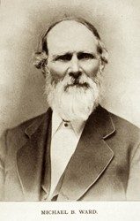
Michael Beem Ward was born in Licking County, Ohio on 6/11/1818. He and Amelia Elizabeth Harmon were married in 1842. The following year their only child, Augusta, was born. Augusta married Raymond R. Rees, co-owner of the Rees-Winans mercantile on the northeast corner of 2nd and Main. Following her husband’s death, Augusta designed largely by herself and built in 1898 the house commonly known as the Rees mansion on the southwest corner of Birch and South Palouse Streets, extant but in a substantially deteriorated condition.
The extent of Ward’s education would seem to have been quite limited. Whitman Achives has a copy of what is catalogued as his diary, but it appears to have been a workbook for letters, all dated in 1851, that he wrote to Amelia in Illinois. One dated 7/19/1851 is worth excerpting:
“Harrison William & my self has got seven hundred dollars by us now & I own eight hundred of it. I have sent two hundred home which I hope you will get & Harrison sent home the same all in Fathers name. I want you to do as you please with the money iff you get it & don’t want for eny thing that you want to eat & ware & take good care of your helth & take good care of Augusta hour baby joy & when you get this I want you to rite soon so as I can send some more money iff that goes safe to you. Your afectionate husband till death this from Michael B. Ward to A. E Ward A. M. Ward.”
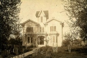
A ca. 1900 photo of the Ward home. The two women on the porch may be Amelia Ward and her daughter Augusta. Whitman Archives.
Ward sold his farm in DeKalb County, Illinois in 1850 and departed solo for California; we can presume he had been bitten by gold fever. After a year, he returned to Illinois, bought and again sold another farm. He then left Illinois once more, this time driving a herd of cattle and taking Amelia with him to Linn County, Oregon where he acquired 320 acres. The Wards left Oregon in 1861, settling in Walla Walla County near the present Prospect Point School where they lived in a log cabin and acquired approximately 700 acres to raise cattle. In 1875 or early 76 they left their log cabin for their new residence on the corner of Poplar and East Streets. The new abode, a far cry from the log cabin, was in the middle of ten acre of orchards and gardens planted by A. B. Roberts. Ward was elected a County Commissioner on 11/5/1878 as a Republican.
In the fall of 1880, Walla Walla was busy planning for a visit from President and Mrs. Rutherford B. Hayes. The Walla Walla Statesman on 10/2/1880 reported:
“Hayes will leave Portland on Monday 10/4 by boat for Walla Walla in a party of 10. He will be taken to the Blue Mountains for a panoramic view of the city. The citizens are requested to decorate their houses appropriately. An arch of welcome is to be constructed over Main at 3rd. The First Cavalry, the Artillery Company, home Guards and Fire Department are to join in the welcome. The street commissioner is to put the streets in ship shape.”
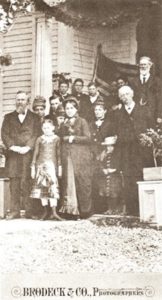
President Rutherford B. Hayes, front left, at the front porch of the Ward home. Mrs. Hayes is front center, and Michael Ward appears on the upper right.
The Ward residence was the only suitable house in Walla Walla to accommodate the Hayes party and the entire party bedded at the Wards’ house. A cot had to be placed in a hallway for the detective assigned to protect the president. Although the presidential party did not dine at the house, Mrs. Hayes offered to assist Mrs. Ward in the kitchen. The Hayes party enjoyed a lavish dinner on October 5th at the Stine House, precursor to the current Dacres Hotel, currently undergoing renovation for an unknown purpose. White satin menus were printed in gold. The courses belied the dusty town and included potages: green turtle a la Anglaise, poissons: salmon a la Cambridge, oysters au coquille, salads, hors d’oeuvres, English plum pudding and Russian Charlotte, a baked pudding with layers of brown cake baked with apples.
Michael Ward died in 1893 at 74 years of age. Amelia died in 1905, at age 86. Both are buried in Mountain View Cemetery. Large garden urns from their home decorate their graves.
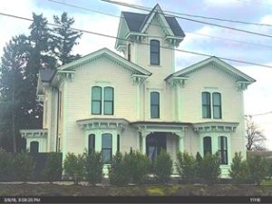
Penny Andres described the Ward house as Italianate. That seems an appropriate appraisal and it may well have been Walla Walla’s only house built essentially in the Italianate style at the time, Italianate having been out of favor for nearly 20 years. Italianate architecture had peaked in the West and Midwest during the 1850s, but architectural styles tended to arrive quite late on the Western frontier. Typically Italianate are the twin low-pitch gables of the main façade with fairly wide eaves embellished by ornamental brackets and bands of modified dentils. The twin one-story bays of the façade are excellent Italianate with their segmented arch windows. The pair of segmented arch windows above the bays are also Italianate, although they would have been more appropriate with each pair embellished by a single heavily hooded round arch. The tower is an anomaly. Italian villas usually had a tower, but this one is jarring because of its steeply pitched cross-gable roof. It’s a beautiful and proud tower, but ill fitted to the Italianate style of the rest of the house. It was removed at some point, but carefully rebuilt in 2008. Consider the symmetry of the Ward house with that of the Kirkman house of 1880 that we know was designed by F. P. Allen; the similarities of the two houses’ façades with their respective bay windows supports the theory that the Ward house was likely a product of Allen’s creation.
As mentioned, the Ward house faced west when built. The 1880 city directory described its location as “head of Poplar e of First.” In 1881 and 1882 city directories it was described as being at 119 East Street. It was listed as “e end of Poplar” in 1889 through 1892. From 1893 through 1905, the last year a Ward lived there, it was listed as owned by “Amelia Ward, widow Michael” at “119 East st.” At some point the house was turned 90 degrees to face north, or Poplar Street. No permit could be located for this move. The first edition of the 1905 Sanborn Fire Map before any updates were pasted onto the various maps shows the house still faced west. Author Penny Andres wrote in her book that the house “was turned to face Poplar Street when that street was built in the early 1900s” and that the move was accomplished by a 13-mule team. Correctly stated, it should have said when Poplar Street was extended east…” Since it is difficult to determine for certain when alterations and corrections were pasted onto the Sanborn maps, it can only be said that the turn occurred after 1905.
W. A. Willcock listed at 228 East Poplar was issued a building permit on 9/6/1928 to build a garage estimated to cost $60. His connection to this property could not be determined.
No evidence of any kind could be located to confirm when Frank and Nancy Josephine Clifton took possession of the parcel on which the house sits. Penny Andres reported this as having occurred in 1936, presumably related to her by Clifton family members. A search of Reverse Indexes to Deeds was checked and double-checked between January 1919 and January 1941; neither Frank nor N. Josephine Clifton’s names appeared as grantees during those years.
In the 1931-32 city directory 228 East Poplar had 12 apartments. The first listing for the Cliftons occupying 228 East Poplar was in the 1939 directory. Josephine (she was usually listed as N. Josephine) operated the Farm Market Cafe on West Main Street. 1941 to 1952 city directories showed the Cliftons living in Apartment 6, and the building was called Beck Apartments. In 1953 the Cliftons moved to Apartment 10. The 1954-55 directory indicated that 228 East Poplar now had 15 apartments with Frank Clifton as manager, living in Apartment 5. By 1955, Frank Clifton was retired and N. Josephine was listed as manager; this arrangement continued through 1962. In the 1963 city directory only N. Josephine was listed living on premises, so Frank may have died in 1962. A death record could not be located.
By 1964, 228 East Poplar had 16 apartments. In the 1967 directory, Joe and Gracie Clifton were listed as owners, living in Apartment 5.. Joe was a farmer. By 1978 only G. E. (presumably Gracie) was listed there, still in Apartment 5; this remained the case until 1990. 1991 contained the last listing for G. E. Clifton at 228 East Poplar. In 1994, J. Clifton was listed as residing in Apartment 6. Although still apartments in 1996, J. Clifton had departed and the city directory for that year only listed 3 apartments as occupied. This remained the same in 2000, the last year city directories were published.
F. R. Clifton was issued a building permit on 1/20/1938 to remodel 228 East Poplar, a job that was estimated to cost $50.
A building permit was issued to F. R. Clifton on 7/10/1956 to remodel apartments. The contractor was listed as R. Pritz, and the estimated cost was $3,000.
Another permit was issued to F. R. Clifton on 9/8/1950 to “add to apartment building.” He listed himself as contractor and estimated the cost to be $12,000.
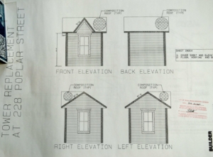
No building permit could be found to remove the tower. However, on 1/18/2008 a permit was granted to reconstruct the tower; it was listed as having 90 square feet. That permit also included conversion of the front portion of the attic to a living unit. The tower was designed by Aaron Hoeft, an engineer and owner of ACH Engineering of Walla Walla. The contractor for rebuilding the tower was Meticulous Touch of College Place. If the recreation was done solely from the one old photo of the house in this report, it was a commendable recreation, very faithful to the original.
In 2011, a permit was granted to consolidate some of the former apartment units.
References
- TitleOne Escrow & Title (formerly Pioneer Title)
- Whitman College Archives
- Gilbert, Frank T., Historic Sketches of Walla Walla, Whitman, Columbia and Garfield Co’s & Umatilla County, OR, Printing and Lithographing House of A. G. Walling, Portland, 1882
- Lyman, Prof. W. D., Lyman’s History of Old Walla Walla County, V. 2, S. J. Clarke Publishing Company, Chicago, 1918
- Diary of Michael B. Ward, 1851 (although catalogued as a diary, this photostat document appears to have been Ward’s first draft of letters he probably later copied in letter form and mailed home to his wife)
- Sanborn Fire Insurance Maps, various years
- Cindy Fazio, Cadastral GIS Technician, Walla Walla County Assessor’s Office
- Andres, Penny, Walla Walla: Her Historic Homes, Vol. 3, 1998
- Mitchell, Claire, Walla Walla Remembers, 1969
- Walla Walla City Directories, various years
- Pam Rangier, City of Walla Walla Development Services Department
Addendum Illustrations
Following are additional illustrations for this report.
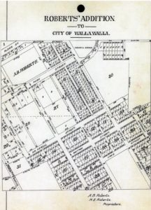
The plat map of Roberts’ Addition to the City of Walla Walla. There have been numerous street name changes since this map. Roberts Street is now South Palouse Street. Ebbie Street is now Park Street. What is labeled Park Street to the immediate west of A. B. Roberts’ unnumbered block is now East Birch Street. The Ward home was located somewhat south of the marker 673 2/3rds feet.
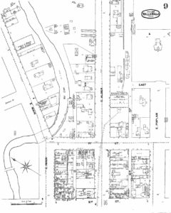
The 1894 Sanborn Fire Insurance Map. The Ward residence is located near the upper right under the oval that dates the map to April 1895.
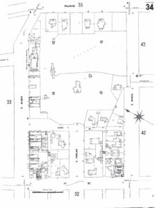
The first edition of the 1905 Sanborn Map shows the residence still faced west. It can be seen near the center of the map.




![77-Wainwright[1]](https://ww2020.net/wp-content/uploads/77_Wainwright1-180x115.jpg)
