History of 215 North Madison Street, Walla Walla, WA
Legal Description
Beginning at the Southeast corner of Lot 1 in Block 1 of the Amended Plat of Isaacs’ Third Addition to the City of Walla Walla, according to the official plat thereof of record in Volume C of Plats at Page 19, records of Walla Walla County, Washington, and run thence Westerly, along the Southerly line of said Lot 1 and Lot 2 in said Block, a distance of 108.5 feet; thence Northerly at right angles 36.4 feet; thence Easterly, parallel to the Southerly line of said Lots 1 and 2, a distance of 110.25 feet to a point in the East line of Lot 1; thence South along the East line of said Lot 1, a distance of 36.4 feet to the point of beginning.
Title and Occupant History
Washington Territory was created in 1853. In 1854, the new territorial legislature created Walla Walla County, which stretched from the crest of the Cascade Mountains to the crest of the Rocky Mountains in the present states of Washington, Idaho and Montana. In 1855, Isaac Stevens, governor of Washington Territory, held a council on the banks of Mill Creek at the present site of Walla Walla with representatives of regional Indian tribes to purchase land from them. The Yakamas, Cayuses and Walla Wallas were dissatisfied with the treaties and the intrusion by whites into their lands before the treaties’ ratification, and war followed. Missionaries, former French-Canadian employees of the Hudson Bay Company trading post at Wallula, and soldiers at the military Fort Walla Walla were the primary European occupants of the area prior to 1859, when the treaties were finally ratified and the land was opened for settlement. The transfer of ownership occurred by virtue of a treaty signed on June 9, 1855 in Walla Walla and ratified on March 8, 1859 by President James Buchanan, in which all of the land in the Walla Walla area was acquired from the Cayuse and Walla Walla Indian tribes.
The town of Walla Walla was originally laid out by County Surveyor Hamet Hubbard Case in 1859, prior to its formal incorporation as a city in 1862, as a one-quarter mile square with its eastern side centered on the point where Main Street crossed Mill Creek (at roughly the point where it does now). The original plat was lost, probably in the fire of 1865. Thus, the earliest plat on file is one made by W. W. Johnson, City Surveyor, in July 1865 that claims to have made corrections to Case’s survey. Johnson’s survey was made the official plat of the City of Walla Walla on September 25, 1866, and was filed and recorded July 5, 1867.
2215 North Madison Street is located in Isaacs Third Addition, named for Henry P. Isaacs and Lucie Isaacs, who played an important role in the city, and for whom Isaacs Avenue is named. Isaacs was influential in the development of Walla Walla as a wheat growing area. Whitman Professor W. D. Lyman in his 1918 History of Old Walla Walla County states that Isaacs “demonstrated to the farmers that wheat could be produced profitably on the hills and uplands which in those early days had been given over to stock-raising.” He built numerous flour mills throughout the Northwest. According to Lyman, Isaacs’s “knowledge of the manufacture and handling of flour became proverbial and he was recognized as an authority on all matters pertaining thereto.” He found markets for wheat in the Orient, especially China. The Isaacses and their son J. C. Isaacs also founded the Walla Walla Water Company, providing Walla Walla with a reservoir, ditches, conduits and the possibility of irrigation for crops. The right to utilize subterranean water pertaining to the properties affected is included in several deeds in the area.
H. P. Isaacs died intestate in 1900. In 1903, the Isaacs heirs, his children, formed the H. P. Isaacs Company. The breaking up of an 80-acre piece resulted in the development of Isaacs Third Addition to the City of Walla Walla, the plat for which was filed 12/20/1899. An Amended Plat of Isaacs Third Addition was filed 5/2/1900.
The first recorded transaction involving land that includes the present address 215 North Madison Street was a deed filed on 7/25/1863 in which John Haley sold 26 and 81/100th acres to William H. Patten and wife for $100. No patent to John Haley in Walla Walla County could be found on the online search website of the Bureau of Land Management. William and Elizabeth Patten owned several other parcels on University and Pearson Streets that later became part of Isaacs Third Addition, as well as land in Green’s Park Addition along Alvarado Terrace. In 1863, Patten was a Walla Walla County Commissioner.
7/25/1863, Deed, John Haley, grantor; Wm. H. Patten and wife, grantees, All that portion of the S.W. ¼ of the N.W. ¼ of Section 21 in Township 7 North in Range 36 East bounded as follows: commencing at the quarter post on the East side of Section no. 20, thence running North 11.95 chains, thence North 81° East to the East boundary of said quarter, quarter, thence South to the South East corner of said quarter, quarter, thence West to the place of beginning, containing 26 81/100 acres more or less, $100.
4/20/1864, Warranty Deed, Wm. H. and Elizabeth A. Patten, grantors; H. P. Isaacs, grantee, the following described tract of land lying in said County and Territory, to wit: beginning at the S.W. corner of the N.W. quarter of the S.W. quarter of Section 21 in Township 7 North of the Range 36 East, run thence East 80 rods, thence North 135 1/2 rods, thence West 118 88/100 rods, thence on a straight line to the place of beginning, containing 80 acres, and to be the same as contained in said boundary more or less in Section 20 and 21 North of Range 36, Township 7. $2,000.
4/5/1866, Warranty Deed, William H. and Elizabeth A. Patten, grantors; Henry P. Isaacs, grantee, beginning at the S.W. corner of the N.W. quarter of the S.W. quarter of Section 21 in Township 7 North of Range 36 East and running thence East 80 rods, thence North 135½ rods, thence South 81° West 118 88/100 rods, thence on a straight line to the place of beginning, containing 80 acres and to be same as contained in said boundary more or less in Section 20 and 21, Township 7 North of Range 36 East, $200.
9/22/1881, Lease, H. P. and Lucie Isaacs, lessors to J. C. Isaacs, lessee, extensive property in Section 21, Township 7 North, Range 36 East, for 25 years, $10,000.
9/11/1886, Deed, H. P. Isaacs, grantor; The Walla Walla Water Company, a Corporation, grantee, at the request of J. C. Isaacs, to maintain the reservoir now on the property and all ditches, conduits to and from the reservoir and the building covering the reservoir, and a strip of land 15 feet wide around the building, plus numerous other stipulations and limitations, $1 and other valuable consideration.
6/27/1894, Quit Claim Deed, Lucie Isaacs, grantor; Henry P. Isaacs, grantee, all the right, title and interest and estate of said party of first part in all land… described as follows: beginning at the S.W. corner of the N.W. quarter of the S.W. quarter of Section 21, Township 7 North of Range 36 East, and running thence due East 80 [rods], and thence due North 13 1/2 rods to a stake; thence South 81° West 118 88/100 rods to a stake, thence on a straight line to the place of beginning, containing about 80 acres, and to be the same as contained in said boundary more or less in Sections 20 and 21 in Township 7 North of Range 36 East, $1.
3/28/1896, Warranty Deed, Henry P. and Lucie Isaacs, grantors; Miles C. Moore, W. W. Baker and H. C. Baker, trustees, grantees, 3 multigraph pages of properties in Section 21, Township 7 North, Range 36 East, including the roadway on the east side of Whitman College as far east as Mill Race (later Isaacs Avenue), $20,000.
12/2/1899, Warranty Deed Against Grantors, W. W. Baker, H. C. Baker and Miles Moore, grantors; The City of Walla Walla, a Corporation, grantee, parcels in 21-7-36 (including what is now 215 North Madison Street), 22-7-36 and 14-7-36. All land owned by Henry and Lucie Isaacs, including Isaacs’ North Pacific Mill “A”.
3/22/1901, Deed, A. J. Patten et al, grantor; heirs of H. P. Isaacs, all children of William H. and Elizabeth A. Patten, grantees, to clarify a “fatal defect” in the deed of 4/5/1866, $1 paid by heirs of H. C. Isaacs.
11/22/1901, Quit Claim Deed, Lucie Isaacs and Bessie J. Savage (formerly Isaacs), grantors;
Grace G. Isaacs, Charlotte M. Doheny (formerly Isaacs), Edwin S. Isaacs, J. P. Isaacs, grantees, Lots 1, 2, 3, 5, 6, 7, 8, 12, 13, 14 in Block 1, Isaacs’ Third Addition plus numerous others in Isaacs’ Addition, Isaacs’ First Addition and Isaacs’ Second Addition, $1.
3/20/1903, Warranty Deed, Lucie Isaacs and Bessie J. Savage (formerly Isaacs), Edwin S. Isaacs as attorney in fact, grantors; Ella A. Metzger, grantee, Lot 1, Block 1, Isaacs’ Third Addition, $600. This transaction is the first transaction solely transferring the lot where 215 North Madison is situated.
10/24/1905, Warranty Deed, Ella A. and C. E. Metzger, grantors; A. M. Cation, grantee, Lot 1, Block 1, Isaacs’ Third Addition, excepting the westerly 10 feet, $4,300. C. E. Metzger was a building contractor whose residence is listed in the 1904 Walla Walla city directory as 588 Isaacs Avenue. A. M. Cation was the secretary/manager of Walla Walla Lumber Company. The 1905 city directory lists his residence as 547 Washington Street. The 1906 directory lists him at 588 Isaacs Avenue. The 1909-10 directory lists his home address as 504 Catherine Street.
7/3/1907, Quit Claim Deed, A. M. and Nannie E. Cation, grantors; The H. P. Isaacs Company, a corporation, grantee, to quit claim the following: beginning at the N.E. corner of Lot 1, Block 1 of Isaacs’ Third Addition, thence Southerly 17.8 feet to the Southerly line of Isaacs Avenue, thence Westerly along the Southerly line of Isaacs Avenue 101 feet to the Westerly line of said Lot 1, thence Northerly 16.3 feet to the N.W. corner of said Lot 1, thence Easterly in a straight line to the point of beginning, containing 1,717 square feet of land more or less, being that part of said lot now used for street purposes by the City of Walla Walla, $1.
3/11/1908, Warranty Deed, A. M. and Nannie E. Cation, grantors; Harry Gilbert, grantee, beginning at the S.E. corner of Lot 1, Block 1 of Isaacs’ Third Addition, thence Northerly along the West line of Madison Street a distance of 60 feet, thence Westerly in a straight line to a point 10 feet Easterly of a point in the West line of Lot 1, thence Southerly in a straight line to a point in the South line of Lot 1 10 feet Easterly from the S.W. corner of Lot 1, thence Easterly along the South line of Lot 1 to the place of beginning, $10. Although the Gilbert family owned this property for 30 years, they did not occupy 215 North Madison Street, evidently renting it to a variety of others. Walla Walla city directories did not begin to include reverse listings of occupants by street until 1931, when the directory for 1931-32 listed Arnott Woodroofe living at 215 North Madison. Mr. Woodroofe was the architect who designed the current church building for First Congregational Church on South Palouse Street. Woodroofe was born in England, migrated to Vancouver, B.C. where he designed a number of buildings, later located in and formed a partnership with another architect in Tacoma for a few years, designing a number of craftsman houses in that city, before moving to Walla Walla. He did not remain here long, moving to Spokane where he died.
2/18/1938, Warranty Deed Subject to Life, Harry G. and Cara Y. Gilbert, grantors; Marjorie Gilbert Gunderson, daughter of grantors, grantee, Lots 1 and 2, Block 1, for love and affection.
8/7/1972, Statutory Warranty Deed, Marjorie Gilbert Gunderson, grantor; Lester A.and Thelma Jean Downing, Lot 1, Block 1, $10.
8/17/1972, Deed and Seller’s Assignment of Real Estate Contract, Marjorie Gilbert Gunderson, grantor; quit claims Lot 1, Block 1 to Janet Marie Headley and Richard Gilbert Gunderson, grantees, for love and affection. Lester A. and Thelma Jean Downing to assume the real estate contract. The Downings occupied 215 North Madison. He was a corrections officer at Washington State Penitentiary; she was in charge of payroll at Rogers Walla Walla Cannery. The Gundersons resided at 217 North Madison.
5/18/1977, Statutory Warranty Deed, Lester A. and Thelma Jean Downing, grantors; Jon N. and Kristin I. Gerde, grantees, Lot 1, Block 1, $15,000. The Gerdes are not included in Walla Walla city directories.
9/13/1978, Statutory Warranty Deed, same as deed of 8/7/1972, in fulfillment of the real estate contract.
9/22/1978, Statutory Warranty Deed, Richard Gilbert Gunderson, grantor, Lester A. and Thelma Jean Downing, grantees, same as deed of 9/13/78.
9/24/1978, Statutory Warranty Deed, Jon N. and Kristin I. Gerde, grantors; Russell W. and Susan L. Davidson, grantees, Lot 1, Block 1, $10 and other valuable consideration. The Davidsons resided in Prescott, so presumably 215 North Madison continued as rental property.
5/19/1983, Quit Claim Deed, Russell W. and Susan L. Davidson, grantors; Rudolph E. and Bernice V. Meiners, grantees, deed in lieu of foreclosure. The Meiners are not listed in city directories; the 1983 issue lists 215 North Madison as vacant.
11/1/1983, Real Estate Contract, Rudolph E. and Bernice V. Meiners, grantors; Dorothy Anderson, grantee, an undivided one-half interest in the property, for love and affection. Dorothy Anderson is listed in the city directory as retired. In view of the fact that the Meiners bequeathed one-half interest in the house to her, she appears to have been a relation. Perhaps she was Bernice Meiners’ mother.
12/6/1984, Quick Claim Deed, Marjorie Gunderson, grantor; Janet M. Headley and Richard G. Gunderson, grantees, an undivided one-half interest in the property, for love and affection.
7/31/1989, Statutory Warranty Deed, Rudolph E. and Bernice V. Meiners, grantors; Estate of Dorothy Anderson, deceased, Beginning at the Southeast corner of Lot 1, Block 1 of the Amended Plat of Isaacs’ Third Addition… and run thence Westerly along the Southerly line of said Lot 1 and Lot 2… a distance of 108.5 feet; thence Northerly at right angles 36.4 feet; thence Easterly parallel to the Southerly line of said Lots 1 and 2 a distance of 110.25 feet to a point in the East line of Lot 1 thence South along the East line of said Lot 1 a distance of 36.4 feet to the point of beginning. $40,000.
3/6/1990, Special Warranty Deed, Estate of Dorothy F. Anderson, deceased, grantor; Sandra L. Price and Donna M. Hogenson, grantees. Same legal description as the deed of 7/31/1989. The 1991 city directory lists the house occupied by a renter.
3/6/1992, Sellers’ Assignment of Real Estate Contract and Deed, Rudolph E. and Bernice V. Meiners, grantors; Rudolph E. and Bernice V. Meiners Living Trust, grantee, to transfer the real estate contact between the Meiners and Dorothy Anderson.
7/25/1994, Statutory Warranty Deed, Sandra L. Price and Donna M. Hogenson, grantors; Vicki L. and Charles R. Brock, $65,900. Same description as 3/6/1990. In 1994, Charles Brock was a student at Walla Walla Community College, and Vicki Brock was employed at Strauser Manufacturing.
5/29/1996, Statutory Warranty Deed, Janet M. Headley and Richard G. Gunderson, grantors; John B. and Sharon L. Zachary, grantees, $10 and other valuable consideration.
There is no listing for the Zacharys in the 1996 city directory. Note that Headley and Gunderson, who lived at 217 North Madison were the grantors in the above transaction. The last Walla Walla city directory was published in 2000, thus it is not possible to learn if the owners between 2006 and 2011 occupied 215 North Madison Street.
11/8/2006, Statutory Warranty Deed, Vicki L. and Charles R. Brock, grantors; Casey T. and Susan E. McGrath, grantees, the south 36.4 feet of Lot 1, Block 1, $125,000.
11/27/2006, Special Warranty Deed, Sharon L. Watts as representative of the estate of John B. Zachary, deceased, grantor, and Sharon L. Watts, a married person, grantee, the deceased’d interest in Lot 1, Block 1.
6/26/2008, Statutory Warranty Deed, Casey T. and Susan G. McGrath, grantors; James M. and Susan A. Johnson, grantees, $187,500.
8/31/2011, James M. and Susan A. Johnson, grantors; Julia A. Ireland, grantee, Lot 1, Block 1, as above.
Construction of Building
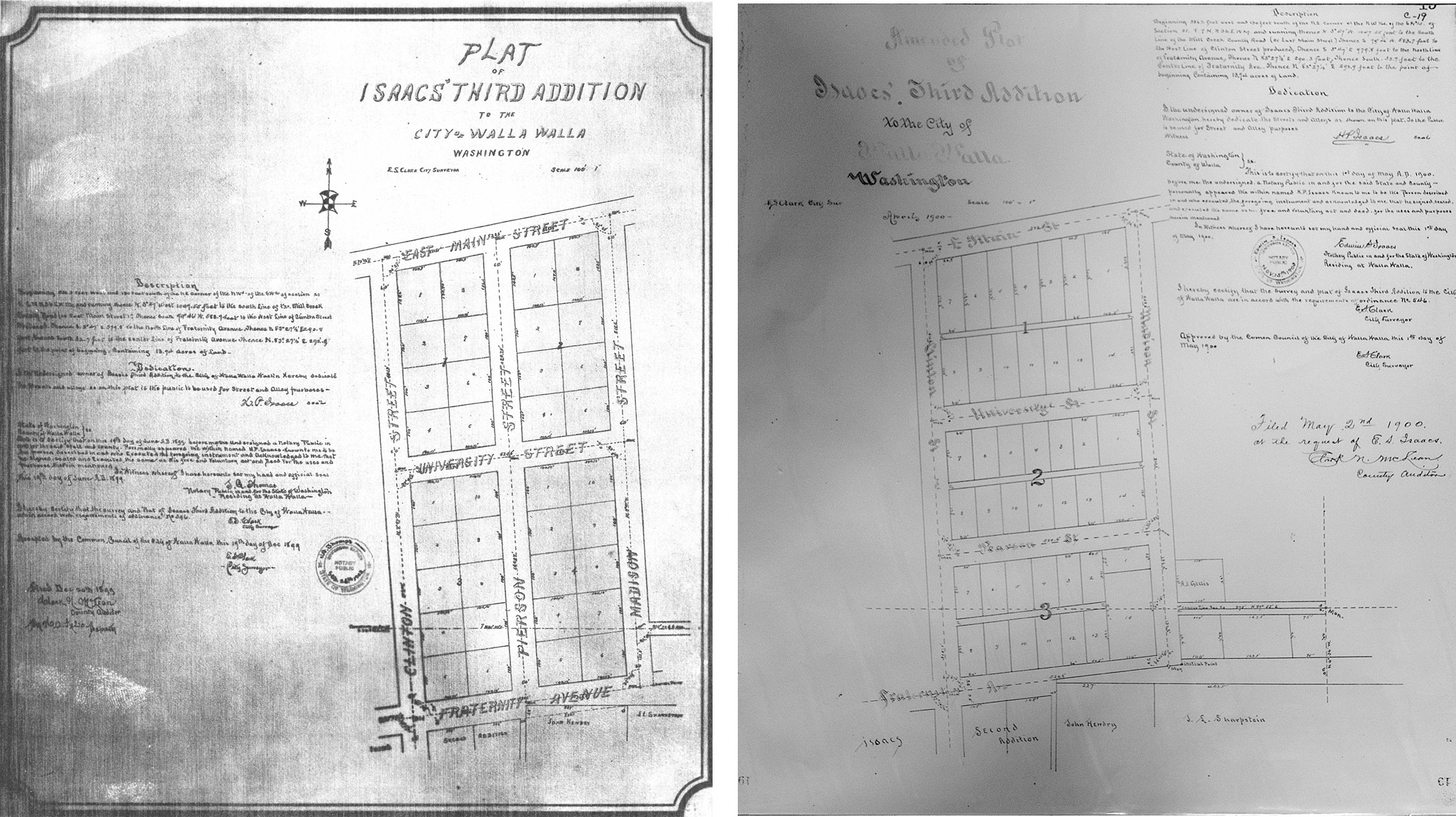
Left: the 1899 original plat of Isaacs’ Third Addition. Note that what is now Block 1 was two blocks at that time. Also observe Pearson Street running north and south between the two blocks.
Probably because of unrecorded probate transfer, this has been a confusing property in terms of which listed owners were involved, in what capacity they were involved and what was their mutual connection in view of the fact that while they did not occupy 215 North Madison they did occupy both 217 North Madison Street and 1142 East Isaacs Avenue on the corner and 588 Isaacs. Former researcher Kathy Weingart, who researched 1142 East Isaacs in 2008, encountered the same problem. She wrote, “the building date was dependent upon the resources listed below, which show that Charles and Ella Metzger built the home to be used as a boarding house in 1903. It continued to be a rental for many years, divided between the first and second floors. This lovely home is now a single-family dwelling and is 105 years old.”
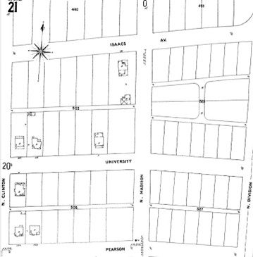
The first edition of the 1905 Sanborn Fire Insurance map shows the replatted Isaacs’ Third Addition as it is configured today. 1142 East Isaacs and 215 North Madison are clearly seen; 217 North Madison has not yet been constructed.
The County Assessor dates this house to 1910 which is probably incorrect. Assessor dates are often estimates. City building permits are not preserved beyond mid-September 1907, so no permit exists for this house. Charles and Ella Metzger acquired Lot 1 of Block 1 in March 1903 for $600. The Metzgers sold Lot 1 of Block 1 in October 1905 for $4,300. Charles Metzger was a building contractor who constructed the large house at 1142 East Isaacs Street. Having purchased the property in early 1903 and having sold it in late 1905, Mr. Metzger could have built 215 North Madison Street in 1903, 1904 or 1905. Metzgers did not live in the house and, like the house they built at 1142 East Isaacs, used it for rental income.
To add to the confusion regarding this property, Isaacs’ Third Addition was initially platted in 1899 and filed 12/20/1899. What currently is Block 1 was really two blocks bounded by Clinton Street on the west and Madison Street on the east. On the north the boundary was Main Street (now East Isaacs Street) and to the south University Street. Pearson Street is shown running north and south between the two blocks.
Within five months, Isaacs’ Third Addition had been replatted and filed 5/2/1900. Pearson Street that bisected the two earlier blocks was removed and shows on the amended plat precisely where it remains today running east and west one block south of University Street. The earlier Blocks 1 and 2 were combined as Block 1, with Block 2 now lying south of Block 1.
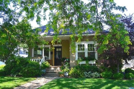
215 North Madison Street is a one and one-half story moderately small Craftsman with a delightful street appearance. It features a hip roof with a small projecting gable. Siding is clapboards. Windows were probably all double-hung originally. The large window to the left of the front door that opens on the inset front porch is now single paned. The porch balustrade is definitely Craftsman-derived. The house is a contributing member to this historic neighborhood.
Resources
- TitleOne Title & Escrow (formerly Pioneer Title)
- Walla Walla County Auditor
- Whitman College Archives
- Walla Walla City Directories (various years)
- Sanborn Fire Insurance Maps
- Walla Walla Public Library
- Report on 1142 East Isaacs Avenue by Katherine Weingart, April 2008


