Welcome to the Wallula History Website
![Nez Perce camp outside walls of Old Fort Walla Walla on the Columbia River, Washington. Engraving by John M. Stanley, 1853. [University of Washington Library Archives #NA4169]](https://ww2020.net/wp-content/uploads/uw-archives_walla_walla_1853.jpg)
Nez Perce camp outside walls of Old Fort Walla Walla on the Columbia River, Washington. Engraving by John M. Stanley, 1853. University of Washington Library Archives #NA4169
Wallula has many fascinating stories to tell.
These include the early geologic history of the region displaying the effects of the Missoula Floods 15,000-18,000 years ago, and its role as a traditional village and gathering site for Native Americans. It was also a Lewis & Clark camp site, and the site of the first fur trading post in the region.
In the 1860s Wallula became a major steamship port which brought thousands of miners to the Idaho gold fields, as well as agricultural products to market. In the 1870s, it was the terminus of the Walla Walla and Columbia River Railroad, the Northwest’s first rail line of any length; in the 1880s it became a link in transcontinental rail lines.
Three successive towns called Wallula were built there, the first in 1860 on the ruins of Old Fort Walla Walla, the second along the new transcontinental line in the 1880s, and the third in 1953 when backwaters of the new McNary Dam flooded the area and the town was moved to higher ground.
Geology at Wallula
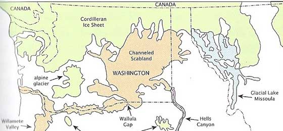
Wallula Gap, 15,000 Years Ago. From “Where the River Bends” Robert J. Carson, et al.
From 15,000-18,000 years ago what many geologists believe were the Earth’s largest floods raced through Wallula Gap. Some of these floods were as many as twenty times as large as the combined discharge of all the world’s current rivers
The Gap was only large enough to accommodate about half the discharge from ice-dammed Glacial Lake Missoula, which caused the water to surge at speeds of up to 60 miles per hour through the opening at Wallula. These floodwaters created channeled scablands, surged up the Walla Walla, Yakima and other valleys, roared through the Columbia River Gorge and inundated the Willamette Valley on their way to the ocean.
Glacial Lake Missoula, comparable in size to Lake Erie, was formed during the glaciations of the Pleistocene ice age, which began about two million years ago, when a tongue of ice flowed south from British Columbia’s Cordilleran ice sheet and blocked the Clark Fork of the Columbia River. When a series of approximately 2000-foot-thick ice dams broke, Lake Missoula emptied in massive floods, each lasting a few days. In these Missoula Floods, icebergs rode the waves, depositing at Wallula a variety of exotic rocks. The Two Sisters monument there is an example of some of the flood-created scablands at Wallula.
–From Where the Great River Bends, Robert J. Carson, editor
Native Peoples
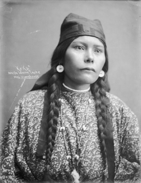
Keka, WW Tribe, Lee Moorhouse photo. Photo courtesy of Confederated Tribes of Umatilla Indian Reservation.
Wallula was a permanent village site for Wallulapum (Walla Walla) Indians as well as a place of intertribal encampments of Walla Wallas, Cayuses, and Nez Perces numbering several thousands in late summer. Here they traded, celebrated, discussed political concerns, renewed friendships, courted, raced horses, and gambled.
Those who lived in the Wallula area between about 11,000 and 8,000 years ago lived in temporary shelters in small mobile groups, foraging a wide variety of plant and animal resources, including fish, river mussels, deer, elk, antelope, birds, rabbits, and hares. Later, the people became more sedentary and small villages appeared, including longhouses.
Around 1720 the horse reached the Wallula area, greatly increasing mobility and the range of trade and resource gathering. However, the underlying culture continued to rely on a seasonal round centered on salmon fishing, root gathering, and deer and elk hunting.
–From Chiefs and Chief Traders, Theodore Stern, and “Pre-history: The Waluulapam at Wallula Gap,” Catherine E. Dickson, in Where the Great River Bends.
Lewis and Clark
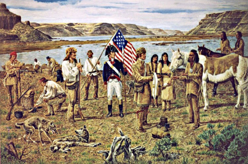
Lewis & Clark meeting Yellepit at Wallula, painting by Norman Adams, 2000. Courtesy of Fort Walla Walla Museum
The Corps of Discovery camped just south of Wallula on October 15, 1805 on their way to the Pacific Ocean. On their return in April of 1806, they camped for two nights at the Walla Walla village on the north side of the river, where Chief Yellepit gave Captain Clark a white horse, and Clark gave Yellepit his sword. The explorers then swam their horses and ferried their baggage across the river in two canoes provided by the Walla Wallas, after which the party camped for the night just north of the mouth of the Walla Walla River.
In his journal, Lewis described the Walla Wallas as “the most hospitable, honest, and sincere people that we have met with in our voyage….This village consists of 15 large mat lodges. A little before sunset the Chymnahpos (Yakamas) arrived. They joined the Wallahwollahs and waited very patiently to see our party dance. The fiddle was played and the men amused themselves with dancing about an hour. We then requested the Indians to dance which they very cheerfully complied with.”
Fur Traders
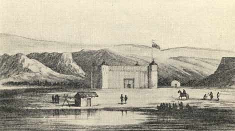
Fort Nez Perces, 1818, from A.Ross, Fur Hunters of the Far West.
In 1818, the North West Company built Fort Nez Percés at the mouth of the Walla Walla River. In 1821 this was rebuilt by the Hudson’s Bay Company as its Fort Walla Walla trading post, a center for outfitting and supplying the inland empire fur brigades, as well as for trade with local tribes.
Fort Nez Perces was heavily fortified, and became known as the Gibraltar of the Columbia. Beaver pelts from the vast inland region were shipped through Wallula to Vancouver, and from there were loaded onto ships for England. The authority of the Hudson’s Bay Company was respected by local tribes, and many of their mostly French-Canadian Métis employees settled in the Walla Walla Valley in an area that became known as Frenchtown, often marrying local Indian wives.
Steamboats
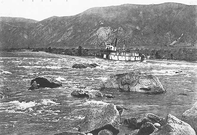
The OSN’s Tenino avoided large boulders as it steamed from the Deschutes River to Wallula. Oregon Historical Society negative, OrHi 9029
In territorial days, Wallula served as a major steamship port for the inland areas of Washington, Oregon, and Idaho. The first steamboat, the Colonel Wright, arrived at Wallula in April 1859 carrying military supplies for the new US Army Fort Walla Walla at the new town of Walla Walla to the east. After that, regular steamship service could be relied upon for carrying cattle, sheep and wheat to coastal markets and for bringing settlers to the interior. Miners also used the route to travel to British Columbia, Idaho, and Montana.
The steamboats on the Columbia River were eventually replaced by the major railroads which they arrived at Wallula in the 1880s.
Railroads
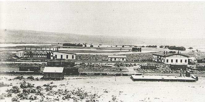
The NP facilities included an eight-stall roundhouse and car repair sheds. The rail cars are on sidings. Columbia River islands are in the background. Whitman College and Northwest Archives
In 1871, construction of the first Pacific Northwest railroad of any length began at Wallula. The Walla Walla and Columbia River Railroad was completed in 1875 connecting the town of Walla Walla with the steamship dock at Wallula. The only prior tracks in the region were the short portage lines at the Cascades and between the Dalles and Celilo Falls. In 1880, the Oregon Railroad and Navigation Company began a line from Wallula to Portland, which by 1883 was linked at Wallula to the Northern Pacific’s transcontinental railroad. In 1888, five railroads brought as many as 15 to 30 trains a day to Wallula.
Despite a town having been established around the ruins of Old Fort Walla Walla where the steamship dock and the WW&CR railroad depots were located, the OR&N built its track and depot a mile inland because its freight business no longer relied on river traffic. A new town of Wallula was then built around these tracks to capitalize on the railroad and its workers and customers, after which the first town was abandoned.
Though Wallula aspired to be “The Railroad Center of the Northwest,” in 1884 the NP built the new town of Pasco, and in 1887 the Union Pacific bought the OR&N and extended its line to Umatilla, where most of the trainmen relocated in 1889. When Lake Wallula inundated the Wallula depot facilities in 1953, the tracks were moved east to their present location, and the town of Wallula was again relocated, this time to a hill to the northeast.
The Towns and Lake Wallula
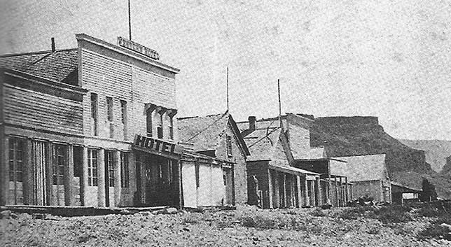
In the 1860s miners arriving by steamboat in Wallula could purchase supplies and arrange for transportation to Walla Walla or distant mining districts. Many travelers praised James Vansyckle for building a well-located port in a sandy, treeless environment. Oregon Historical Society negative, CND1 6015
The first town of Wallula was established in 1860 by James Vansyckle, primarily as a depot for the gold rush into the eastern mountains of Washington Territory. It also served travelers on the Mullan Road linking Fort Benton on the Missouri River with Fort Walla Walla on the Columbia. The original town thrived during the gold rush,but declined by the late 1860s.
In the 1880s the railroads created a temporary boom for the second town built a mile east along the new mainline. With the construction of McNary Dam and the 1953 inundation of both town sites by Lake Wallula, the location of most of Wallula’s human history is now under water. The third town of Wallula looks down from a low hill to the northeast.
The Wallula Historic Site
There has long been recognition of the need to create an interpretive site to honor Wallula’s significant history. After several unsuccessful attempts along US 12, the Walla Walla 2020 citizens group has obtained permission from the Washington State Department of Transportation for an interpretive site at the eastern entrance to the Wallula Gap at a turnout on US 730 just downstream from Milepost 5, where interpretive signage has now been installed. This site is the closest point of land to many of the events that took place at the mouth of the Walla Walla River in the 1800’s and early 1900’s, which is now underwater from the backwaters of McNary Dam.
The site also provides access to the spectacular open space on the bluffs overlooking the Columbia River and along the river bank itself, which is a popular fishing spot. Click here for information on hikes from the Wallula Historic Site.
Much information provided is from the book Where the Great River Bends edited by Robert J. Carson, with chapters by Michael E. Denny, Catherine E. Dickson, Lawrence L. Dodd, and G. Thomas Edwards. Thanks to Wildhorse Foundation and UP Foundation.
Historic Sites & Markers Project
To help honor and maintain this and other Walla Walla area historic sites, tax-deductible contributions can be sent to Walla Walla 2020, PO Box 1222, Walla Walla WA 99362.
Information on the Walla Walla 2020 Historic Research & Plaque Project is available here.