History of 641 Bryant Avenue, Walla Walla, WA
Abbreviated Legal Description
Bryant’s Acre Tracts, Tax Lot 20 Lot 1
Full Legal Description
Beginning at the Southeast corner of Lot 1 of Bryant’s Acre Tracts, according to the official plat thereof of record in the office of the Auditor of Walla Walla County, Washington, and running thence North 89°53’ West, along the South line of Lots 1 and 2 of said Bryant’s Acre Tracts, a distance of 228.0 feet; thence North 00°07’ East, parallel to the West line of said Lot 2, a distance of 141.3 feet to a point in the center of the channel of Garrison Creek; thence along the center of the channel of Garrison Creek by the following courses and distances; North 72°22’ East 10.5 feet; thence South 89°02’ East 34.0 feet; thence North 86°18’ East 45.07 feet; thence South 75°12’ East 43.4 feet; thence North 86°18’ East 45.07 feet; thence South 75°12’ East 43.3 feet; thence North 80°39’ East 30.4 feet; thence North 47°36’ East 16.28 feet; thence South 89°53’ East 55.0 feet to a point in the East line of said Lot 1; thence South along the East line of said Lot 1, a distance of 151.0 feet, more or less, to the point of beginning.
Title and Occupant History
Washington Territory was created in 1853. In 1854, the new territorial legislature created Walla Walla County, which stretched from the crest of the Cascade Mountains to the crest of the Rocky Mountains in the present states of Washington, Idaho and Montana. In 1855, Isaac Stevens, governor of Washington Territory, held a council on the banks of Mill Creek at the present site of Walla Walla with representatives of regional Indian tribes to purchase land from them. The Yakamas, Cayuses and Walla Wallas were dissatisfied with the treaties and the intrusion by whites into their lands before the treaties’ ratification, and war followed. Missionaries, former French-Canadian employees of the Hudson Bay Company trading post at Wallula, and soldiers at the military Fort Walla Walla were the primary European occupants of the area prior to 1859, when the treaties were finally ratified and the land was opened for settlement. The transfer of ownership occurred by virtue of a treaty signed on June 9, 1855 in Walla Walla and ratified on March 8, 1859 by President James Buchanan, in which all of the land in the Walla Walla area was acquired from the Cayuse and Walla Walla Indian tribes.
The town of Walla Walla was originally laid out by County Surveyor H. H. Case in 1859, prior to its formal incorporation as a city in 1862, as a one-quarter mile square with its eastern side centered on the point where Main Street crossed Mill Creek (at roughly the point where it does now). Case’s plan was filed and recorded July 5, 1867 in Book A of Plats, Page 1. The City of Walla Walla received a Trustee Town site from the U. S. Government that consisted of 80 acres, issued on July 20, 1869 by the Vancouver, W. T. District Land Office.
On April 1, 1865, part of a U.S. Patent consisting of 40 acres was granted to Thomas Cantrill, as recorded in the Vancouver, W.T. District Land Office. The first entry in the local land records was when this area of town was platted as Bryant’s Addition and filed September 15, 1880. Bryant’s Addition is described on the plat map as the “South ½ of the Northwest ¼ of Section 28, Township 7. N.R. 30 East of the Willamette Meridian and the North ½ of the Southwest ¼ of the Northwest ¼ of the same section.” The boundaries were Howard, Pleasant, Division and what was then called Nursery Street and is now Chestnut Street.
The plat of 1880 did not include all of the land John and Viretta Bryant owned. In 1905, Viretta Bryant, by then a widow, platted additional land adjacent to Bryant’s Addition, extending it south to Bryant Avenue. The plat was filed as Bryant’s Acre Tracts on May 31, 1905. The east and west boundaries remained Division and Howard Streets. Following is the legal description: “Beginning at the West line of Division Street 670 feet South of the center line of Locust Street in Bryant’s Addition to the City of Walla Walla; thence West parallel with the said center line of Locust Street 1,251 feet, more or less, to the East line of Park Street (now Howard Street); thence South along the East line of Park Street 302 feet; thence East parallel with the said center line of Locust Street to the West line of Division Street; thence North along the West line of Division Street 302 feet to the point of beginning.”
The 1905 plat map reveals that the only portion of Bryant’s Acre Tracts partitioned into lots for development at that time was along the north side of Bryant Avenue. 641 Bryant Avenue occupies Lot 1 of Bryant’s Acre Tracts.
3/9/1881, Warranty Deed, John and Viretta Bryant, grantors; John F. Boyer, grantee, “the Southwest quarter of the Northwest quarter of Section 28 in Township 7 of Range 36…”, $1,000, apparently a mortgage.
12/3/1881, Warranty Deed, John F. and Sarah E. Boyer, grantors; Viretta Bryant, grantee, as described in Warranty Deed of 3/9/1881, $1 and trust imposed upon the parties of the first part, indicating satisfaction of the mortgage.
12/15/1886, Lease/Indenture, John and Viretta Bryant, grantors; John T. Mills, grantee, “…land bounded on the North by the alley running through Blocks 7 and 8 in Bryant’s Addition…and on the East by Division Street, on the West by Park Avenue, and on the South by a road leading from Park Avenue to the Ice Pond of Jacob Betz and a fence leading from the Ice Pond Northeasterly to Division Street, for a term of five years, 3/1/1886 to 3/1/1891, at $300 for the first two years and $325 for the remaining years, payable in gold coin…”
1/23/1888, Lease, John and Viretta Bryant to Lee Yune (or Yunc [illegible]; Chinese laborers were not permitted to hold title to land and their recorded names frequently were imprecise interpretations of their Chinese name), “…bounded on the West by Park Avenue, on the North by the alley running East-West through Blocks 7 and 8 of Bryant’s Addition, on the East by Division Street, on the South by a ditch leading from Division to the Ice Pond of Jake Betz and the wagon road leading from the Ice Pond Westerly to Park Avenue, containing about 16 acres more or less at $250 for the first 2 years, and $300 for the last 5 years…” This was the first of a series of leases between 1888 and 1900 to Chinese covering a larger tract containing this property.
4/18/1905, Quit Claim Deed, John P. Bryant, a single man; Mandana and Milford H. Broughton; Cyrus M. and Emma E. Bryant, grantors; Viretta Bryant, a widow, grantee, “…the North half of the tract of land being laid off into town lots in Bryant’s Addition, excluding lots 1 and 2 of Block 6…”, $1.
4/20/1905, Affidavit, Viretta Bryant to The Public, to establish herself as the widow of John Bryant, deceased in 1898, and that the grantors in the Quit Claim Deed of 4/18/1905 were of more than 21 years of age as of 4/7/1905.
10/21/1905, Warranty Deed, Viretta Bryant, a widow, grantor; Katie L. Paul, grantee, Lot 2 of Bryant’s Acre Tract, $10. What is most interesting about this Warranty Deed is what was not included. The following Warranty Deed that does not appear in the ARB file for 641 Bryant Avenue discloses that Viretta Bryant granted to William D. Paul Lot 1 on the same date for $10; Lot 1 is where 641 Bryant Avenue was built.
5/4/1908, Warranty Deed, William D. and Katie L. Paul, grantors; Andreas Bard, grantee, Lots 1 and 2, Bryant’s Acre Tract, $3,000.
5/19/1908, Warranty Deed, Andreas and Christine Bard, grantors; Enid Smitten, grantee, Lots 1 and 2, $3,500.
1/8/1945, Quit Claim Deed, Lester L. Hobbs, surviving spouse of Mrs. Lester L. Hobbs, neé Enid Padmore Smitten, deceased, grantor; William L. Stirling as the Administrator of the estate of the deceased, grantee, the entire interest in Lot 1 of Bryant’s’ Acre Tracts and a portion of Lot 2 to the surviving spouse, $1.
1/8/1945, Quit Claim Deed, Freeman Cornwall Smitten, a bachelor and brother of Mrs. Lester L. Hobbs, neé Enid Padmore Smitten, deceased, grantor; William L. Stirling as the Administrator of the estate of the deceased, grantee, that he quits claim for the above 2 lots, $1.
1/23/1945. Administrator’s Deed, William L. Stirling, as the Administrator of the estate of Mrs. Lester L. Hobbs, neé Enid Padmore Smitten, deceased, grantor; Roland E. Miller and Ivar E. Highberg, grantees, Lot 1 and a portion of Lot 2, Bryant’s Acre Tract, $1,500.
2/6/1945, Quit Claim Deed, Ivar E. and Mary B. Highberg, grantors; Roland E. and Emma Jane Miller, grantees, Lot 1 and a portion of Lot 2, $10 and other valuable considerations.
4/10/1947, Warranty Deed, Roland E. and Emma Jane Miller, grantors; Daniel M. and Beatrice Hill MacDonald, grantees, Lot 1, Bryant’s Acre Tract, $10.
12/8/1948, Warranty Deed, Daniel M. and Beatrice Hill MacDonald, grantors; Conrad and Haidee Tucker, grantees, $10. Conrad Tucker (1914–1999) was a wheat farmer, born in Weston, OR. He and Mrs. Tucker were married in 1937.
5/31/1971, Statutory Warranty Deed, Conrad and Haidee Tucker, grantors; Abbas A. and Stephanie J. Sameh, grantees, $10.
6/11/1993, Quit Claim Deed, Stephanie J. Sameh, grantor; Abbas A. Sameh, grantee.
Construction of Building
The Assessor’s build date for 641 Bryant Avenue is 1948. However, Building Permit 1213 for the house was not issued until 4/12/1949, for which Conrad Tucker paid a fee of $37 to build a house estimated to cost $20,000. He listed himself as contractor. Mrs. Conrad (Haidee) Tucker informed this writer that her late husband’s brother, Stanley Tucker, who lived just over the border in Milton-Freewater, was the architect of the house. Stanley Tucker was a member of the Umatilla County Planning Commission Zoning Advisory Committee, and served as chair of the Umatilla Democratic party.
Conrad Tucker was elected in 1961 to a two-year term on the Board of Directors of the Walla Walla Grain Growers Cooperative. He was commodore of the Walla Walla Yacht Club in 1958.
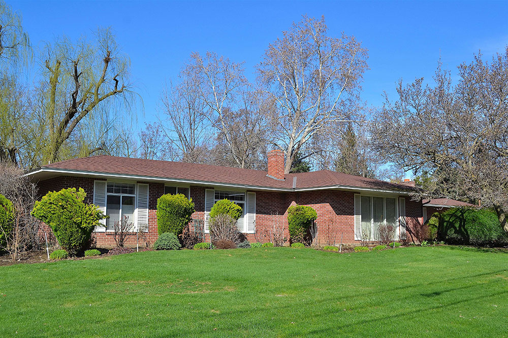
Built at a time when the threat of communism gripped America, the concrete foundation walls of 641 Bryant are nine inches thick, in compliance with bomb shelter standards. Garrison Creek that runs through the property is channeled in pipes under the driveway to the twin garages. During winter freezes, the water, warmer than 32°, prevents snow and ice from building up on that portion of the driveway.
Conrad and Haidee Tucker had been living at 516 Catherine Street and were listed at that address in the 1949-1950 City Directory. It was not until the 1951-1952 edition of the City Directory that their address was given as 641 Bryant Avenue. However, Mrs. Tucker confirmed that they moved into their new home during August 1950, following completion of construction that year.
641 Division Street is a beautiful example of a mid-century Ranch house, although in the sophistication of its design it stands a notch or two above the more ubiquitous Ranch houses. The house reflects to a marked degree what brought about this type of home. As Americans became more reliant on the automobile they built homes farther away from the local center of commerce because they no longer were exclusively dependent on public transportation. Lots became larger. Two garages that were attached to the house frequently replaced the small, single detached garage. Ranch houses were almost without exception one story with either gabled or hipped roofs (641 has a hipped roof) with wide overhangs. Brick was often used for siding, as in this house, and so-called picture windows brought the suburban outdoors “indoors.” 641 Bryant Avenue reflects all of these attributes in an elegant manner and is certainly a most valuable addition to Walla Walla’s cityscape.
References
- Whitman Archives
- Walla Walla City Directories
- Mary Meeker, Lead Researcher, Walla Walla 2020
- Mrs. Conrad (Haidee) Tucker
- Tracy Williams (Tucker granddaughter)
- City of Walla Walla Public Works
- www.geni.com
- www.ancestry.com
- www.findagrave.com
- The Pendleton Record, March 16, 1972
- Federal Register, Notice of National Park Service, Interior, 8/13/2008


