
History of 605 South Division Street, Walla Walla, WA
Legal Description:
Beginning at a point in the east line of Division St. 500.75 feet south and 30 feet east of the N.W. comer of the N.E. quarter of the N.W. quarter of Section 28 in Township 7 North, of Range 36 East of the Willamette Meridian, and running thence E. 160 feet, thence S. 75 feet, thence W. 160 feet, thence N. along said east line of Division St. 75 feet to the point of beginning. Also, that part of the vacated portion of County Road No. 441, now known as Edgewood St., abutting upon the north line of the tract above described.
Title and Occupant History:
August 6, 1888 – Joshua C. Isaacs sold the property described below to Daniel Stewart for $1800: beginning at a point 276.5 feet S. of the N.W. corner of the N.E. quarter of the N.W. quarter of 28-7-36 and running thence. due east 940 1/7 feet, thence due south 278 feet, thence due west 940 1/7 feet, thence due north 278 feet along center of the county road to place of beginning (6 acres). (Deed Book 41, Page 29; hereinafter 41/29) Joshua C. Isaacs was listed in the 1889 city directory as boarding with H. P Isaacs. Henry P. Isaacs started several flour mills in eastern Washington, Idaho. and Oregon–the 1862 Walla Walla mill was sited where Wildwood Park is today. W. D. Lyman referred to him as “the foremost miller on the Pacific coast.” in his History of Walla Walla County CN. H. Lever, 1901, p. 313). H. P. Isaacs was an entrepreneur with many interests: he successfully experimented with almost every variety of fruit and vegetable grown in the northern temperate zone (he planted one of the first orchards in this area). he was a “booster” of Walla WalIa– encouraging raid lines in the valley and introducing the bill that established the state penitentiary in Walla Walla–and he owned large tracts of land that his wife, Lucie, and their offspring managed after his death. Daniel Stewart is listed in the 1892-1901 city directories as a farmer with a residence at 334 Whitman St.
February 17, 1890 – Daniel and Margaret Stewart. husband and wife. sold the property described below to Irene S. Goodman for $1000: Beginning at a point 500.75 feet south of the N.W corner of the N.E. quarter of the N.W. quarter in 28-7-36, run thence east 440 feet, thence south 152 feet, thence west 440 feet. thence north 152 feet to the point of beginning.
March I5, 1890 – Joshua Isaacs, a single man, quit claimed and conveyed all interest in the property described below to Daniel Stewart for the recorded consideration of $1: begin at a point 278.5 feet south of the N.W. corner of the N.E. quarter of the N.W. quarter in 28-7-36, run thence east 940 feet, thence south 371 feet, thence west 940 feet, thence north 371 feet to the point of beginning. (45/449)
March 14, 1901 – Daniel Stewart quit claimed and conveyed all interest in the property described above to Irene S. Goodman for the recorded consideration of $1 to correct error in the description. This document also stated that Daniel Stewart had acquired all interest in the land from the heirs of Margaret Stewart. (77/209) Mrs. Irene S. Goodman is not listed in the 1892-94 city directories; in 1898-1902 she is listed as residing at 334 Whitman St.
March 15, 1901 – Crassus Stewart, Thales D. Stewart, Robert L. Stewart, C. B. Stewart, Kate Stewart Nixon, Ida S. Winans, and Ella S. Cameron quit claimed and conveyed all interest in the property to Irene S. Goodman for the consideration of $1.
April 21, 1902 – lrene S. and William S. Goodman, wife and husband, sold the property described below to Otto Labudde for $1400: same as property except dimensions are listed as 440 feet by 148.75 feet. in 82/552, the same parties recorded a quit claim deed signed April 24, 1902 which described the property dimensions as 4401 x 1521.
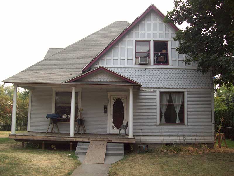
Construction of the House:
Although the county assessor lists the year built as 1892, I found no evidence supporting this claim. The April 1902 selling price of $1400 for the 4401 x 1521 parcel suggests no substantial building on the site. The first listing I found in the city directories is for Otto Labudde in 1904 (there is no 1903 directory) as a farmer with a residence on the east side of Division three lots south of Whitman; that directory also lists Ida Labudde as boarding at 605 Division. The foregoing suggests a building date of 1902 or 1903. (The house is drawn on the Sanborn Insurance Map of 1905. p. 56 and on microfilm. Whitman College Archives.)
May 29. 1911 – Otto and Caroline Labudde sold the property described below to H. H. McLean for the recorded consideration of $10: same as the legal description with the exception that the dimensions are listed as 180 x 75. The 1912-13 city directory list H. H. McLean as the manager of the McLean Grain Agency with a home on Rural Delivery route 5. The directories for 1904-1910 list Otto Labudde at 605 S. Division; the 1911-12 directory lists him at 609 S. Division.
April 14, 1913 – H. H. and Maggie McLean, husband and wife, sold the property (which carried a mortgage from the Alliance Trust Co. Ltd.) to S. H. Hough for the recorded consideration of $1. S. H. Hough is listed in the 1914 directory as having a home on Rural Delivery route 2.
July 9, 1914 – S. H. and Grace M. Hough, husband and wife, sold the property to Sophie L. Yoder for the recorded consideration of $1. Sophie L. Yoder is not listed in the city directories for 1914 and 1915.
November 7, 1914 – Sophie L. and Francis M. Yoder, wife and husband, sold the property to Frances E. Parker, a spinster, for the recorded consideration of $1. Frances E. Parker is not listed in the city directory for 1915.
September 26, 1917 – The Sheriff of Walla Walla County filed an indenture recording the sale of the 180′ x 75′ property at public auction on September 23, 1916 to the Alliance Trust Co., Ltd., a corporation, for $3132.81. This sale arose out of a Superior Court case, Alliance Trust Co., Ltd, plaintiff, against H. H. and Maggie McLean, Frances E. Parker, Soloman P. and Mary I. Wright, and H. D. May, defendants.
September 30, 1920 – The Alliance Trust Co., Ltd., a British corporation. sold the 180′ x 75′ property to Chas. J. and Ella Springer, husband and wife, for $3300. (Deed #11I665) The 1921 city directory lists Charles J. Springer as the county sheriff with a home at 605 S. Division.
December 5, 1937 – Charles J. Springer died and left the property in his will to his wife, Ella Springer, and $100 to his daughter Zora May Springer. (Superior Court Case #27435. on microfilm in Walla Walla County Clerk’s Office, Walla Walla County Courthouse, Walla Walla, Washington)
November 10, 1943 – Ella Springer died and left the property in her will to her daughter, Zora May Cornwell. (Superior Court Case #31089, on microfilm in County Clerk’s Office, Courthouse)
July 25, 1952 – James R. Cornwell and Charles E. Cornwell quit claimed their interest in the property in the legal description to Zora May Cornwell, whose husband is Edward R. Cornwell, in consideration of the “Love and Affection which the Grantors have for the Grantee, who is their mother.” (#356498) The 1921 directory lists Zora May Springer as a teacher with a residence at 605 S. Division; the 1951-52 directory list Edward and Zora May Cornwell with a home at. 605 S. Division and Charles E. and June E. Cornwell, husband and wife, residing at 605 S. Division and Jas. R. Cornwell, U.S.A.F. as having a residence at 605 S. Division.
March I5, 1971 – Zora May Cornwell quit claimed the property in the legal description to Charles Edward Cornwell and James Richard Cornwell in consideration of “Love and Affection.” (#513194) The 1972 directory lists James Richard Cornwell as retired and living with his wife, Karen L., at 605 S. Division, but does not list Charles Edward Cornwell.
May 4, 1973 – a Certificate of Payment of Inheritance Tax was filed with the State Department of Revenue in the matter of the estate of James R. Cornwell. It listed the inheritance of the property know as 605 S. Division, with an assessed value of $3100, by Charles Cornwell. (#529102)
December 26, 1973 – Charles E. and Donna D. Cornwell, husband and wife, sold the property in the legal description to Richard W. and Rose Marie Baldwin, husband and wife, for $8,900. (#9304066) The 1974 directory lists Richard W. Baldwin as retired and Rose· Marie Baldwin as an employee of the U. S. Corps of Engineers, both with a residence at 605 S. Division.
August I5, 1978 – in a Deed and Purchaser’s Assignment of Real Estate Contract, Richard W. and Rose Marie Baldwin conveyed and quit claimed the property, and assigned the real estate contract above (#9304066), to Joseph C. and Iris L. Hardy, husband and wife for the consideration of $27,000. (#7807248) The 1985 directory lists Joseph C. Hardy as president of Hardy & Son, 410 Chase $100, with a residence on Rural Delivery route 5.
April 29, 1986 – an Agreement for Deed was signed in which Joseph C. Hardy, as trustee of the Joseph C. and Iris L Hardy Trust, agreed to sell the property to Naomi Helton, a single person, for $45,000. (#9305231, see also #9310606 and #8603005) The 1987 directory list Naomi Helton at 605 S. Division; the 1992 directory lists her at the same address and as the owner of the Trouble Shooter Accounting Service.
October 12, 1993 – Naomi Helton. a single person, sold the property to Meribeth Dahlberg, a single person [Whitman College Registrar], for $55.000. (#9310607)
February 29, 1996 – Meribeth Dahlberg, a single person, sold 15’ of the property to Steven E. and Joanna L. Henry, husband and wife, for $10 “and other good and valuable consideration.” (#9601954)
prepared by Michael W. Smith, 3/96