History of 507 Bryant Avenue, Walla Walla, WA
Abbreviated Legal Description
Lot 8 of Bryant’s Acre Tracts
Full Legal Description
Beginning at a point on the Northerly side of Bryant Avenue, which is 150 feet Westerly, measured along the Northerly line of said Bryant Avenue, from the Southeast corner of Block 8 of Bryant’s Acre Tracts, according to the Official Plat thereof on file in the Office of the Auditor of Walla Walla County, Washington; and running thence at right angles, Northerly 115 feet; thence at right angles, Westerly 50 feet; thence at right angles, Southerly 115 feet; thence at right angles, Easterly 50 feet, to THE PLACE OF BEGINNING.
Also, Commencing on the South line of Block 8 of Bryant’s Acre Tracts, according to the Official Plat thereof on file in the Office of the Auditor of Walla Walla County, at a point 200 feet West of the Southeast corner of said Block; and running thence at right angles, North 115 feet, to a point; thence in a straight line Southwesterly, a distance of 127.5 feet, more or less, to a point in the South line of said Block which is 55 feet West of THE POINT OF BEGINNING; thence East on the South line of said Block, a distance of 55 feet, to THE PLACE OF BEGINNING.
Also, Commencing at a point 200 feet West and 115 feet North of the Southeast corner of Block 8 of Bryant’s Acre Tracts, according to the Official Plat thereof on file in the Office of the Auditor of Walla Walla County; and running thence East and parallel with the South line of said Block 100 feet; thence at right angles, North 87 feet; thence in a straight line Southwesterly, a distance of 122.1 feet, more or less, to THE POINT OF BEGINNING.
Also, Commencing at the Southeast corner of Block 8 of Bryant’s Acre Tracts, according to the Official Plat thereof on file in the Office of the Auditor of Walla Walla County; and running thence in a Westerly direction, along the North line of Bryant Avenue, a distance of 100 feet, to THE PLACE OF BEGINNING; thence at right angles, Northerly 115 feet; thence West 50 feet; thence South 115 feet; thence East 50 feet, to THE PLACE OF BEGINNING.
EXCEPTING THEREFROM the following tract, to-wit:
Beginning at a point in the South line of Tract 8 of Bryant’s Acre Tracts in the City of Walla Walla, according to the Official Plat thereof recorded in Volume C of Plats at Page 39, records of Walla Walla County, which point is 75 feet West, measured along said South line, from the Southeast corner of said Lot; and running thence North, parallel to the East line of said Lot, 185 feet to the center line of Garrison Creek; thence South 73 degrees 18 feet West 41.7 feet; thence South 64 degrees 59 feet West 16.6 feet; thence South, parallel to said East line, 166 feet to a point in the South line of said Lot; thence East, parallel to said South, line 55 feet to THE POINT OF BEGINNING.
All situated in Walla Walla County, State of Washington.
Title History
Washington Territory was created in 1853. The new legislature created Walla Walla County in 1854, which stretched from the crest of the Cascade Mountains to the crest of the Rocky Mountains in the present states of Washington, Idaho and Montana. In 1855, a treaty council was held on the banks of Mill Creek at the present site of Walla Walla to purchase land from the Indians. The Yakamas, Cayuse and Walla Wallas were dissatisfied with the treaties and war followed. Missionaries, former French-Canadian employees of the Hudson Bay Company trading post at Wallula, and soldiers at the military Fort Walla Walla were the primary European occupants of the area prior to 1859, when it was opened for settlement. The U.S. Government, in a treaty signed on June 9, 1855 in Walla Walla and ratified on March 8, 1859 by President James Buchanan, acquired all of the land in this area from the Cayuse and Walla Walla Indian tribes.
Walla Walla was originally laid out by County Surveyor H. H. Case in 1859, before its formal incorporation as a city in 1862, as a one-quarter mile square with its eastern side centered on the point where Main Street crossed Mill Creek (at roughly the point where it does now). The City of Walla Walla received a Trustee Town site from the U.S. Government that consisted of 80 acres, issued on July 20, 1869 by the Vancouver, W.T. District Land Office. Main Street originally followed the old Nez Perce Indian Trail. Consequently, the streets leading off of it were at right angles to it and were not in a north-south orientation. This was corrected as the city moved eastward which gave Walla Walla its peculiar street pattern with the three-street intersection at Palouse, Boyer and Main Streets. To the original plat, additional parcels were annexed from time to time, usually bearing the name of the landowner of record at the time the additions were made.
The property at 507 Bryant Avenue is part of a U.S. Patent on 40 acres granted to Thomas Cantrill on April 1, 1865, as recorded in the Vancouver, W.T. District Land Office. The first entry in the local land records was when this area of town was platted as Bryant’s Addition and filed September 15, 1880. Bryant’s Addition is described on the plat map as the “South ½ of the Northwest ¼ of Section 28, Township 7. N.R. 30 East of the Willamette Meridian and the North ½ of the Southwest ¼ of the Northwest ¼ of the same section.” The boundaries were Howard, Pleasant, Division and what was then called Nursery Street and is now where Chestnut Street is located.
The plat of 1880 did not include all of the land John and Viretta Bryant owned. In 1905, Viretta Bryant, by then a widow, platted additional land adjacent to Bryant’s Addition, extending it south to Bryant Street. The plat was filed on May 31, 1905 at 2:00 PM. The east and west boundaries remained Division and Howard Streets. Following is the legal description: “Beginning at the West line of Division Street 670 feet South of the center line of Locust Street in Bryant’s Addition to the City of Walla Walla; thence West parallel with the said center line of Locust Street 1,251 feet, more or less, to the East line of Park Street (now Howard Street); thence South along the East line of Park Street 302 feet; thence East parallel with the said centre line of Locust Street to the West line of Division Street; thence North along the West line of Division Street 302 feet to THE POINT OF BEGINNING.”
The 1905 plat map reveals that the only portion of Bryant’s Acre Tracts partitioned into lots for development was along the north side of Bryant Avenue. 507 Bryant Avenue occupies Lot 8 of Bryant’s Acre Tracts.
Property and Occupant History
3/9/1881 – Warranty Deed (which appears to be a mortgage), John & Veretta Bryant (a multiplicity of spellings of names appears on documents and will be included as found in this report), grantors; John F. Boyer, grantee, $1,000. John Bryant was born in Virginia on March 29, 1839 and died October 16, 1898. Viretta Bryant (Viretta is the most common spelling found on documents pertaining to this property) was born in 1884 and died December 21, 1926. Both are buried in the IOOF section of Mountain View Cemetery. Lyman’s History of Old Walla Walla County states that John Bryant was a State Representative in 1872. The 1881 Walla Walla City Directory lists John Bryant as a street contractor. The 1888 Walla Walla City Directory lists “John Bryant with Jacob Betz, residence South end Chandler, Bryant’s Addition.” Jacob Betz was the owner of Star Brewery.
12/2/1881 – Warranty Deed by grantors, John F. & Sarah E. Boyer; to Viretta Bryant, grantee, $1 and “trust imposed upon the parties of the first part. Sell convey remise release and confirm unto the said party of the second part, her said heirs and assigns forever.”
12/15/1886 – Lease, by John& Viretta Bryant to John T. Miles.
1/23/1888 – Lease, by John& Viretta Bryant to Lee Yune, $250 each first 2 years, $300 each year last 5 years. This portion is described on the Lease document as “West by Park St., North by alley running east and west through Blocks 7 and 8, East by Division, South by the ditch from Division West to the ice pond of Jake Betz and Wagon Road leading from the ice pond West to Park, containing ca. 16 acres.”
3/9/1892 – Assignment of Lease, by Lee Yune, a Chinaman (this term, pejorative by current standards, is incorporated in this chronology as it appears on the original documents) to Jake Hock, a Chinaman.
1/6/1894 – Lease, by Verita& John Bryant to Yick Hack, a Chinaman, and his wife, name unknown, $300 for the year 1894, $500 for 1/1/1895 through 1/1/1898. The legal description for this lease remains essentially the same as that on 1/23/1888 with the following difference: “West by Park St., North by alley running east and west through Fricks 7th and 8th Sts…”
10/19/1897 – Indenture, Viretta& John Bryant to Sim Sing (Chinaman), for same tract formerly rented to Yick Hock, for 10 years, $400 for 1898, $500/year for last 9 years.
8/21/1900 – Agreement, Viretta Bryant to Chung Lon and Gin Wing who will assume rental formerly assigned to Sim Sing.
4/18/1905 – Quit Claim Deed, John P. Bryant (a single man [son of John & Viretta Bryant]), grantor; Viretta Bryant, a widow, grantee, $1.
4/21/1905 – Affidavit, Viretta Bryant to The Public, to establish rightful progeny of Viretta Bryant and the late John Bryant.
3/15/1907 – Deed, Viretta Bryant, a widow, grantor; Jessie Rankin, unmarried, grantee, $1,090.60. (No listing could be found for Jessie Rankin as a resident of the city of Walla Walla or of Walla Walla County.) This Deed appears to contain the first significant reduction in the property that currently defines 507 Bryant Avenue, as noted: “East on the North side of Bryant Avenue 200 feet, thence at right angles Northerly 115 feet, thence at right angles East 200 feet to the Eastern boundary of Block 8, thence Southerly along the Eastern line of Block 8 115 feet to THE PLACE OF BEGINNING.”
3/15/1907 – Warranty Deed, Jessie Rankin, unmarried, grantor; Henry J. Kaseberg, grantee, $1,300. (Mr. Kaseberg lived at 154 East Chestnut.)
3/15/1907 – Deed, H. J. & Annie Kaseberg, grantors; Riley Sexton, grantee, $1,300. (Mr. Sexton, a thresher, lived at 560 Pleasant.)
4/18/1908 – Deed – Riley& Jennie Sexton, grantors; Frank Blake, grantee, $1. (Frank Blake resided in Walla Walla County.)
5/25/1910 – Deed, Frank & Julia Blake, grantors; Phoebe Gore, grantee, $350. (The Gores will be discussed in greater detail under Construction of Building.) The legal description of the land acquired by Phoebe Gore is as follows: “Beginning at a point on the North side of Bryant Avenue 150 feet West measured along the Northerly side of Bryant Avenue from the Southeast corner of Block 8 of Bryant’s Acre Tracts, according to the official plat thereof, and running at right angles Northerly 115 feet, thence at right angles Westerly 50 feet, thence at right angles Southerly 115 feet, thence at Right angles Easterly 50 feet to THE PLACE OF BEGINNING.”
12/30/1921 – Lien, City of Walla Walla against Ross Ellis Gore, $31.19, and Phoebe Gore, $58.26 (Simeon T. Gore, husband of Phoebe Gore, does not appear on any document pertaining to 507 Bryant Avenue, other than the building permit for construction of the house at 507 Bryant Avenue. Ross Ellis Gore was the younger of two sons born to Simeon and Phoebe Gore.)
7/14/1927 – Release of Lien, City of Walla Walla to Ross Ellis Gore, $31.19, and Phoebe Gore, $58.26.
10/4/1929 – Quit Claim Deed, Phoebe Gore, a widow, grantor; Ross Gore, grantee, $1.
3/19/1931 – Lis Pendens, Ross Ellis & Vergie A. Gore vs. William H. & Jane Doe Bryant and unknown heirs of each defendant and unknown heirs of John Bryant, deceased, to obtain a decree of the Court settling the title of the plaintiffs to the land as described.
3/19/1942 – Warranty Deed, Ross E. & Vergie A. Gore, grantors; William A. & Florence R. Woods, grantees, $1 and other valuable consideration. This Warranty Deed was dated 2/20/1931, but not filed until 3/19/1942. It is worth noting that the legal description of the property on this Deed included Lot 8 (507 Bryant Avenue) and Lot 9 (that became 511 Bryant Avenue following construction of the house on that property in 1970-71).
Mr. and Mrs. William A. Woods are first listed at 507 Bryant Avenue in the 1931 Walla Walla City Directory. William Woods resided here until his death on 11/1/1978. It was at some point during their long ownership of the house at 507 Bryant Avenue that the upstairs was converted into a separate apartment served by an exterior staircase (extant). The 1937 and 1939 City Directories list a Mrs. Amanda E. Ray as residing at 507 Bryant Avenue along with the Woods’s. City directories between 1946 and 1953 list only Mr. and Mrs. Woods at 507 Bryant Avenue. Beginning with the city directory for 1955, occupants in addition to Mr. and Mrs. Woods were designated as living at “507 Bryant, #1.”
1/16/1946 – Quit Claim Deed, William A. Woods, grantor; Florence R. Woods, grantee, as her separate property, $10.
8/26/1970 – Statutory Warranty Deed, Florence R. Woods, grantor; Joseph O. & Lila M. Emmerson and Thomas J. & Linda R. Emmerson, $10 and other valuable consideration. This is the first legal transaction in which Lot 9 would seem to have been split off from Lot 8, which does not appear to have been part of the sale. (The City Directory for 1971 lists Thomas J. Emmerson as a student at Walla Walla College [now University] and Linda R. Emmerson as the secretary to the Dean of Admissions for Whitman College, and in the 1971 City Directory their address is listed as 511 Bryant Avenue. Joseph O. and Lila M. Emmerson do not appear is city directories and presumably financed the purchase of the property for their son and daughter-in-law. It was during 1970-71 that the house at 511 Bryant Avenue was constructed.)
Undated (probably 1970 or 1971) – Agreement and Covenant for Payment of Charges for Installation of Sanitary Sewer, City of Walla Walla and Thomas J. Emmerson, $145.95.
6/2/1972 – Statutory Warranty Deed, Joseph O. & Lila M. Emmerson and Thomas J. & Linda R. Emmerson, grantors; Roberta H. Bisbee, grantee, $10 and other valuable consideration.
(The 1973 City Directory contains the first listing for Charles L. [Capt., U.S. Navy, ret.] and Roberta Bisbee at 511 Bryant Avenue.)
6/7/1972 – Quit Claim Deed, C. L. Bisbee, grantor; Roberta H. Bisbee, his wife, grantee, $10 and other valuable consideration.
6/12/1972 – Satisfaction of Lien, City of Walla Walla to Joseph O. & Lila M. Emmerson and Thomas J.& Linda R. Emmerson, $145.95.
10/27/1975 – Warranty Deed, Roberta H. Bisbee, as her separate property, grantor; Clarence F. & Lois F. Davis, grantees, $10 and other valuable consideration.
The first city directory listing for Clarence F. and Lois F. Davis is in 1979, and lists their residence as 511 Bryant Avenue. For that year, Florence Woods is the only listed occupant of the house at 507 Bryant Avenue.
3/21/1979 – Statutory Warranty Deed, Clarence F. & Lois F. Davis, grantors; James P. & Marcia H. Tomlin, grantees, $10 and other valuable considerations. (The City Directory for 1980 reveals that James, but not Lois Davis, resided at 511 Bryant Avenue.)
1/6/1987 – Statutory Warranty Deed, James P. & Marcia H. Tomlin, grantors; Robert L. & Christine L. Zagelow, grantees, $10 and other valuable consideration.
9/3/1987 – Quit Claim Deed, Robert L. Zagelow, grantor; Christine L. Zagelow, grantee, in consideration of dissolution of marriage. (Christine Zagelow was the owner of Fit or Fat, and was listed as residing in the house at 511 Bryant, next door to 507 Bryant. Robert Zagelow was never listed in city directories as residing at either 507 or 511 Bryant Avenue.)
2/13/1989 – Quit Claim Deed, Christine L. Patterson, formerly Zagelow, grantor; John L. Patterson, grantee, for purpose of creating common property, ½ interest.
10/20/1994 – Statutory Warranty Deed, Dorothy A. Stemmer, personal representative of the estate of Florence R. Woods (deceased 12/2/1993) grantor; Richard E. and LouAnn C. McKinley, $10 and other valuable consideration. Real estate transactions frequently raise questions that are difficult to unravel. This particular transaction may have involved a small mortgage held by Florence Woods. The legal description of the property transferred to the McKinleys is the same as the current legal description.
1/14/98 – Quit Claim Deed, John F. Patterson, grantor; Christine L. Patterson, grantee, to create separate property. 507 Bryant Avenue is unlisted in city directories from 1995 through 2000. (Christine Zagelow-Berg, formerly Zagelow, formerly Patterson, who owned the house during these years, was listed as residing at 511 Bryant Avenue with John Patterson in 1989. The McKinleys could not be found in city directories.)
10/7/2000 – Statutory Warranty Deed, Christine L. Zagelow-Berg, formerly Patterson, grantor; Raymond R. Rickelman & Susan Stewart-Rickelman, $10 and other valuable considerations. Mr. Rickelman was an employee of the Veterans Administration. The city telephone directory for 2003 (2000 was the last year a city directory for Walla Walla was published) shows the Rickelmans at 511 Bryant Avenue. Raymond and Susan Rickelman sold Lot 9 (511 Bryant Avenue), said sale filed April 8, 2005; Lot 8 (507 Bryant Avenue) is not reflected in this transaction.
9/28/2004 – Statutory Warranty Deed, Richard E. & LouAnn C. McKinley, grantors; Levant L. Woolfe& William E. Fiegenbaum, unmarried men, grantees. The city telephone directories for 2005 – 2008 list Levant Woolfe as residing at 507 Bryant Avenue; there is no listing for Mr. Fiegenbaum.
4/4/2008 – Statutory Warranty Deed, Lavant L. Woolfe & William E. Fiegenbaum, grantors; Stephen H. & Maureen G. Henderson, grantees, $10 and other valuable consideration.
Construction of Building
Simeon Thomas Gore was born March 4, 1849 in Richview, Illinois. He received a B.S. in Architecture from the University of Illinois in 1876. He married Phoebe O. Farmer, also born in Illinois in 1857, in Ashley, Illinois in 1880. The Gores had two children, Dwight Clifford, born in 1883, and Ross Elliott, born in 1889. University of Illinois alumni records for 1882 and 1892 disclose that Simeon Gore had an architectural practice in Chicago.
In or around 1900, the Gores became residents of Weston, Oregon. There are no Gores listed in the 1910-11 Walla Walla City Directory; in the 1911-12 Directory, Simeon and Phoebe Gore are listed as residing at 507 Bryant Avenue, so it is likely that they moved from Weston to Walla Walla in 1910.
Simeon Gore initially listed his occupation in Walla Walla City Directories as architect; in 1921, he changed his occupational listing to contractor. As stated above, his name does not appear on any documents pertaining to the property on Bryant Avenue.
On October 20, 1910, “S. T. Gore” was granted a permit by the City of Walla Walla to construct a dwelling at 507 Bryant Avenue, Permit #904. Mr. Gore was listed as owner and builder. The cost of the dwelling was to be $3,000, and he paid $3 for the permit. While during his residency in Walla Walla he did not affiliate with any architectural firm, instead maintaining whatever practice he enjoyed from his home, he did have a degree in architecture and he listed himself on the building permit as contractor for construction of his home. Thus, it can be said with a reasonable degree of certainty that he also designed the house. Based on city directory listings, it appears that Simeon Gore died in 1928. In the above chronology of the property, Phoebe Gore was listed as a widow on a Quit Claim Deed filed in 1929, and the city directory for that year shows no Gores residing in Walla Walla.
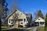
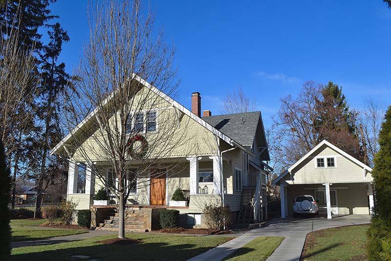
The house, completed in 1911, is a one and one-half story craftsman-style bungalow with a cross gabled roof. The main gable is fore- and aft-oriented. It encompasses the entire breadth of the house and, despite dissimilar windows on either side of the centered front door, the house presents a central massing of the street façade. The side gable rises from a point slightly above the main gable. A deeply recessed front porch traverses the full width of the house. The front door displays faithful arts and crafts detailing. Four hefty, square posts, with simple rounded corbels on each side, support the projecting second floor of the house. Siding on the main floor is clapboard. The second level is sided with attractive fishscale shingles; above the windows of this level vertical shiplap boards with decorative notching are used, giving this part of the house an engaging visual appearance. Upper portions of the double-hung windows, most in pairs or groups of three, are segmented into nine small panes over a single large pane in the lower half. The original concrete front steps were resurfaced with slate tiles by a former owner. An exterior staircase on the east side of the house leads to a door halfway between the first and second levels. The current owners were informed that this was built when the house was divided into two units and a back bedroom upstairs was converted to a kitchen. The double garage – in actuality a carport – was constructed by the current owners to replace an older single garage. It faithfully reproduces all of the architectural detailing of the house, with cars parked in what replicates the recessed front porch of the house. Behind the car-park is a studio. The windows in the gable, saved from the old garage, are purely decorative.
References
Walla Walla city directories
Whitman College Archives
Walla Walla County Auditor Vault (Index To Deeds, 1/1/1902 to 1/1/1970)
Walla Walla Assessor Vault (Assessor’s cards)
Sanborn Fire Maps
Federal Census Records
W. D. Lyman’s History of Old Walla Walla County
ancestry.com (courtesy Mary Meeker)
findagrave.com
Mountain View Cemetery death records
ancientfaces.com
The Alumni Record of the University of Illinois, 1882, 1892 and 1913
Stephen Wilen, Researcher Walla Walla 2020 Research Service P.O. Box 1222, Walla Walla, WA 99362 January, 2014


