History of 339 South Second Avenue, Walla Walla, WA

Property Description:
Beginning at a point in the Easterly line of Second Street in the City of Walla Walla, Washington, which point is 350 feet Southerly, measured along said Easterly line, from the point of intersection of same with the Southerly line of Birch Street in said city; thence Southerly along said Easterly line of Second Avenue South a distance of 82.4 feet; thence North 62º50’ East 20 feet; thence North 62º23’ East 25 feet; thence North 57º50’ East 28 feet; thence North 60º55’ East 47 feet to the Easterly limit of the land formerly owned by Catherine E. Stahl; thence South 29º50’ East to the North line of the land of W. P. Winans; thence North 60º10’ East along the Northerly line of the land of said Winans, to a point therein which is 150 feet Westerly of the Westerly line of First Avenue South in said city, measured along a line drawn parallel to said Southerly line of Birch Street; thence North 29º50’ West 85 feet to a point where a line drawn North 60º10’ East and through the point of beginning would intersect the same; thence South 60º10’ West 150 feet to the point of beginning.
ALSO, beginning at a point in the Easterly line of Second Avenue South in the City of Walla Walla, Washington which point is 266 feet southerly, measured along said Easterly line of Second Avenue South from the point of intersection thereof with the Southerly line of Birch Street; thence South 29º50’ East, along said Easterly line of Second Avenue a distance of 84.00 feet; thence North 60º10’ East 150.0 feet; thence North 29º50’ West 84.0 feet; thence South 60º10’ West 150.0 feet to the point of beginning.
ALSO, beginning at a point in the Easterly line of Second Avenue South in the City of Walla Walla, Washington which point is 485.5 feet Southerly, measured along said Easterly line of Second Avenue South, from the point of intersection thereof with the Southerly line of Birch Street in said city; thence North 29º50’ West, along said Easterly line of Second Avenue South, a distance of 53.10 feet; thence North 62º50’ East 20 feet; thence North 62º23’ East 25 feet, thence North 57º50’ East 28 feet; thence North 60º55’ East 47 feet; thence South 29º50’ East 51.0 feet, more or less, to a point which is North 59º51’ East 120 feet from the point of beginning; thence South 59.51’ West 120 feet to the point of beginning.
ALSO, beginning at a point in the Easterly line of Second Avenue South in the City of Walla Walla, Washington which point is 485.5 feet Southerly from the point of intersection of the said Easterly line of Second Street with the Southerly line of Birch Street in said City; thence North 59º51’ East 120 feet; thence South 29º50’ East 46.41 feet; thence South 60º10’ West 120 feet to the said Easterly line of Second Street; thence North 29º50’ West 45.75 feet to the point of beginning; situate in the City and County of Walla Walla, Washington.
ALSO, beginning at a point in the Easterly line of Second Avenue South in the City of Walla Walla, which point is 608 feet Southerly, measured along said Easterly line of Second Street from the point of intersection thereof with the Southerly line of Birch Street in said City; thence at right angles Easterly 120 feet; thence at right angles Southerly 38 feet; thence at right angles Westerly 120 feet to the Easterly line of Second Avenue South; thence Northerly on said Easterly line of Second Avenue South to the point of beginning; together with a right of way over ad across a strip of land adjoining to the South, said strip being 3.5 feet in width.
Title History:
Washington Territory was created in 1853. The new legislature created Walla Walla County in 1854 which stretched from the crest of the Cascade Mountains to the crest of the Rocky Mountains in the present states of Washington, Idaho and Montana. In 1855 an Indian council was held on the banks of Mill Creek at the present site of Walla Walla to purchase land from the Indians. The Yakima, Cayuse and Walla Walla tribes were dissatisfied with the treaties and war followed. Missionaries, former French-Canadian employees of the Hudson’s Bay Company trading post at Wallula, and soldiers at the military Fort Walla Walla were the primary European occupants of the area prior to 1859 when it was opened for settlement. All of the land in this area was acquired from the Cayuse and Walla Walla Indian tribes by the U.S. Government in a treaty signed on June 9, 1855 in Walla Walla, and ratified on March 8, 1859 by President James Buchanan.
Walla Walla was originally laid out by County Surveyor H. H. Case in 1859, before its formal incorporation as a city in 1862, as a one-quarter mile square with its eastern side centered on the point where Main Street crossed Mill Creek (at roughly the point where it does now). The City of Walla Walla received a Trustee Townsite from the U. S. Government which consisted of 80 acres issued on July 20, 1869 by the Vancouver, W.T. District Land Office. Main Street originally followed the old Nez Perce Indian Trail. Consequently the streets leading off of it were at right angles to it, and were not in a north-south orientation. This was corrected as the city moved eastward which gave Walla Walla its peculiar street pattern with the three street intersection at Palouse, Boyer and Main Streets. To the original plat, additional parcels were annexed from time to time, usually with the name of the land owner of record at the time the additions were made.
A 120 acre homestead claim that included this property was filed by John and Margaret Sparks and Frederik Saddler which was not recorded until September 6, 1872. However John Sparks sold 2.32 acres of his claim on October 18, 1864 to Ludwell J. Rector, including this property. On June 24, 1865 Mr. Rector signed an agreement with Emil Meyer for the right to construct a mash mill on this property and use water from Robert’s Creek (now called Lincoln Creek) for the next 5 years. This property is just south of the original 1869 plat of the City of Walla Walla. It is also at the corner of section and quarter section lines that do not align with either Second Street or Birch Street. This explains the complex legal descriptions that sometimes define property lines in this block by the long-ago adjacent land owners. There were also a significant number of court cases involving this property which were not investigated and may not be reflected in this chain of title.
Ludwell J. and Jane Rector sold this property to R. R. and Augusta Rees on July 10, 1865 for $600. Rees had launched the first issue of the Washington Statesman newspaper on November 29, 1861. On October 8, 1869 Rees sold this and more property to John N. Foster for $1000. On November 20, 1886 Albert Foster signed a quit claim deed for $1000 to his father for his portion of this property which he inherited from his mother Margaret J. Foster, who died prior to 1880. John Henry Foster died on September 27, 1907. His heirs continued to own (and file several law suits, including one in 1924 filed by a granddaughter of John Foster.) this property until Alvin A. King, guardian for Lewis Foster, signed a party wall agreement with A. K and Flora Dice and I. W. and Adelia B. Sims on February 15, 1911, forty-two years after Foster’s purchase of this triangle of early Walla Walla. This party wall was to be 16 inches wide along the north property line, brick with concrete foundations and two-stories tall starting at the street and extending back 120 feet.
Dice was the manager of the Walla Walla Safety Deposit and Trust Company and an insurance agent in 1911. Sims ran a retail grocery at 130 West Main. Dice and Sims also signed a lease with an agreement to build the two-story building at #339 for The T. S. Steel Machine Company. In 1922 Sims sold his interest in the property to Fred Glafke, who was treasurer and manager of Interior Wholesale Grocery Company. On July 30, 1925 Dice and Glafke sold to Douglas V. and Laura Woods for $16,000. Woods operated the Auburn Car Agency at Second and Poplar until he moved it to First and Poplar in 1913. On February 6, 1928 Woods sold to Cyrus B. and Frances Lane for a stated amount of $10. On March 1, 1944 Lane sold to United Union Breweries who brewed and bottled Pioneer Beer in Walla Walla. On April 23, 1947 Pioneer Brewing Company sold this property to Howard J. and Elmer G. Williams of Tacoma. On May 29, 1947 Howard J. and Maud Williams and Elmer G. and Hazel Williams sold this property to W. R. O’Rourke, Sr., whose wife was Jean, for “$10,” including the party wall agreement signed in 1911 between A. K. Dice and John Foster. On December 21, 1956 W. R. O’Rourke, Sr. gave undivided interests in this property to W. R. O’Rourke, Jr. and Winifred Lane for “love and affection. W. R. O’Rourke Sr. died in 1959. Winifred Meissner gave her undivided interest to Bernice and W. R. O’Rourke, Jr. on October 6, 1970. W. R. O’Rourke, Jr. died in 1984 and his widow, Bernice A. O’Rourke, transferred this property to the O’Rourke Family LLC on December 15, 1999.
Occupant History:
The first entry for the two-story brick building at 339 South Second was the T. S. Steel Company garage and shop in 1911 until 1920 when the company moved to 5-11 E. Alder. Prior to having his own business Thomas Steel was superintendent of the Gilbert Hunt Manufacturing Co. and lived at 346 South Palouse. In 1925 D. V. Woods opened a garage and work shop for his Auburn car dealership in this building. His dealership was located at First and Poplar Streets. In 1931 this building became the Union Pacific Stages Garage. From 1933 to 1940 it was the home of Walla Walla-Pendleton Auto Freight, Inland Motor Freight and Old Oregon Trail Freighting. Sometime prior to 1946 its use was described on a fire map as sugar storage plus bottle and carton storage. In 1949 O’Rourke Plumbing and Heating was located here, after moving from their 109 South Second Street location. The business continued to operate here until 1979 when it became Walla Walla Mechanical and Sheet Metal. The building was again vacant from 1983-1985. After that, Custom Auto was located here at least through 1997 when city directories ceased to be published.
Construction of the Building:
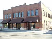
The Whitman College archives records of building permits includes a permit on March 23, 1911 to Dice & Sims for “Improvement: brick garage and machine shop for $12,000.” The builder was S. Henderson. On November 9, 1911 Dice and Sims took out another permit for Improvement: “Add to machine shop, $150.” This indicates a construction date of 1911 for the two story brick building at #339.
References:
Bennett, Robert A., Walla Walla Portrait of a Western Town 1804-1899, Pioneer Press, Walla Walla, 1980.
Bennett, Robert A., Walla Walla A Town Built to be a City 1900-1919, Pioneer Press, Walla Walla, 1982.
Building Permits: Whitman College Penrose Library Archives.
Lyman, Professor W.D., An Illustrated History of Walla Walla County 1901.
H.S. Rich, Co. Author, One Hundred Years of Brewing – A Complete History of Progress Made in Art Science & Industry of Brewing in the World…, 1903.
Ogle’s Standard Atlas of Walla Walla County, 1909
Sanborn Fire Maps: 1884-1905 (with updates until 1950).
Walla Walla City Directories: 1880-present (various publishers–not all years).
Whitman College Archives.
Mary E. Meeker ; Walla Walla 2020 Research Service PO Box 1222, Walla Walla WA 99362 October, 2011


