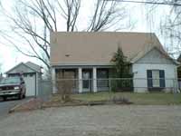
History of 1219 Hobson Street, Walla Walla, WA
Legal Description:
Lot 3 and the West half of Lot 4 in Block 1 of Eastlawn Addition to the City of Walla Walla, as per plat thereof recorded in Volume D of Plats at page 86, records of Walla Walla County; situate in the City and County of Walla Walla, State of Washington.
Title History:
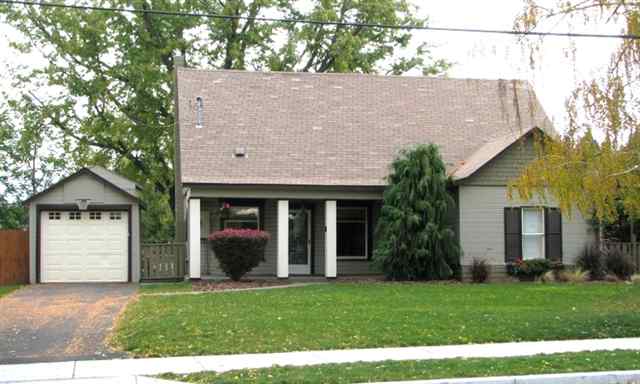
The land that comprises the City of Walla Walla was acquired from the Cayuse and Walla Walla Indian tribes by the U.S. Government in a treaty signed on June 9, 1855 in Walla Walla and ratified on March 8, 1859 by President James Buchanan. Walla Walla was originally laid out by surveyor H.H. Case in 1859, even before its formal incorporation as a city in 1862, as a one-quarter mile square oriented N-S, E-W with its eastern side centered on the point where Main Street crossed Mill Creek (at roughly the point where it does now). To this original area, additional parcels were annexed from time to time. 1219 Hobson is located in Eastlawn Addition which was outside the city limits until the early 1900’s. It was developed largely by George Barber and Hattie E. Barber, who play an important role in the history of this home. The first recorded transaction for 1219 Hobson occurred on December 30, 1878 when George S. Castle and his wife E. C. Castle bought a seven acre parcel, upon which the current house sits, from William and Abegail Matzger for $500. Several transactions dealing separately with the division of the seven acres into a one acre parcel and a six acre parcel occurred from 1879 until 1885. On November 17, 1880 the Castles deeded one acre of that parcel to Morgan P. Castle, a single man, for $100. Morgan Castle then sold the one acre parcel to John R. Tallman and Ella Tallman on July 25, 1881 for $350. On March 10, 1882 the six acre parcel was sold by Daniel and Margaret Stewart to Herbert E. Johnson and Cynthia Johnson for $850. In a Sheriff’s Deed George Castle’s six acre plot had been sold to Daniel and Margaret Stewart for an unstated amount. The one acre parcel was sold on March 8, 1883 by the Tallmans to Thomas Twyman for $500. On March 12, 1883 Twyman purchased the six acre parcel from the Johnsons for $2000. Although the price of that purchase is large enough to include a house, none is shown on the 1894 Fire Map. On December 10, 1885 Thomas Twyman sold the now seven acre parcel to George Barber and Hattie Elizabeth Barber for $1050. George Barber is listed in the 1883 City Directory as a brick mason, in the1892 City Directory as a mason contractor and in the 1893 directory as a contractor and builder located at 20 E. Poplar, “residence same.” George Barber gave a Quit Claim Deed to his wife, Hattie E. Barber on March 23, 1889 for the seven acres and also “other properties” that he owned.The 1909 Walla Walla County plat map shows that George Barber owned 12.82 acres along what is now Hobson St. beyond Hattie Barber’s 7 acres, extending to what is now Wilbur St. A “Deed of Water Rights” filed by the Barbers in 1899 conveyed ownership of the waters of Mill Creek to the Walla Walla Water Company. The 1905 Firemap shows a concrete retaining wall on the south side of Mill Creek long before the Corps of Engineers construction of the current channel. On December 6, 1901 the Barbers negotiated a ten year lease for 2-3 acres to Lee Chung and Lee Dinn for growing fruit trees, berry patches, plants and vines “being the home place of said Lessers.” The exact location of the acreage was not given in the lease documents. The annual fee was to be $340 and the agreement included water rights for irrigation. It was not uncommon at this time for the Chinese population to lease property to do “truck farming” in the Walla Walla/College Place areas. George Barber died in 1914. The Grantor/Grantee records at the Walla Walla County Courthouse show that from 1920-1923 Hattie Barber sold several lots that were part of the Barber parcel . In the 1929-30 City Directory the address of the house is listed as “corner of Roosevelt and Barber Ave.” This is an example of the change in street names and addresses for what is now Hobson St. On September 19, 1938 Mrs. Barber filed a Declaration of Homestead for Lots 2,3,4, & 5 in Block 1 of Eastland Addition, stating “prior to the time of the death of my husband, he and I, and our family were occupying and residing upon and using said premises as a family home, and since his death and in the future”she hoped to continue to live there. The actual value of the property was stated as $2000. On April 2, 1940 Hattie Barber sold Lots 3,4, & 5 in Block 1 to Clark R. Abel, a bachelor. That sale included $116 in unpaid taxes. The address at that time had become 1221 Hobson. On March 4, 1943 Lester Hardin, who worked at a grocery store and was a carpenter, purchased the property from Abel for an unstated amount. Hardin’s address was changed to 1211 Hobson. On December 19, 1947 Hardin, a widower, sold the current property for $2500 to Nell M. Parker and D.M. Parker, who ran Parker Nursing Home located at their 309 Boyer Ave. residence. The Parkers had numerous Walla Walla properties and continued to reside at the Boyer Ave. address. This sale is the first time that the current legal description was used: Lot 3 and the west _ of Lot 4 in Block 1. On August 24, 1949 D.M. Parker, “owner in his own separate right” sold this property for an unstated amount to Harry L. Agrell and Ethel F. Agrell. Agrell was listed as a building contractor residing at 999 Hobson. Like the Parkers, the Agrells did not reside in this home. The1951-52 City Directory uses the current address of 1219 Hobson for the first time after the Agrells sold the home to Robert Wild and Opal Wild on February 16, 1951. Robert Wild was listed as a driver for the Walla Walla Dairyman’s Association in the 1951-52 City Directory. The Wilds took out a $7400 mortgage in 1955, apparently for extensive remodeling of the home, which may explain the mistaken date of construction as 1953-54 in the Walla Walla County Assessor’s records. This is a house that has been extensively remodeled and this was the first time any building permit had been issued for it, since none were required before 1907. On February 17, 1959 Opal Wild, a widow, sold the house to Louis and May Silva. In the 1960 City Directory Louis Silva is listed as a Walla Walla City Patrolman and May Silva is listed as an R.N. At that time, car ownership was listed in City Directories. The Silvas owned a 1950 Chevrolet. On February 28, 1962, the Silvas sold the house to William Thonney and Sharron R. Thonney. William Thonney was listed as a draftsman at the Corps of Engineers. County Assessor office records give the price of the house as $7810. On September 15, 1965 the Thonneys sold the house to Leonard Mayfield and Betty Mayfield for $9250. Leonard Mayfield was listed as an engineer at the Corps of Engineers in the 1966 City Directory. On January 31, 1978 the Mayfields sold to Frank E. Mauro and Roxie D. Mauro for $31,900. On March 14, 1979 the Mauros sold the house to Michael D. Leonetti and Kathy Leonetti for $36,900. Michael Leonetti was employed at Continental Can Co. and Kathy Leonetti was a Clerk in the Walla Walla County Assessor’s Office. The Leonettis later divorced and on May 31, 1996, Michael D. Leonetti, as his separate property, sold the house to Dominic S. Cortinas and Andrea Cortinas for $83,500. The 2003 assessed value of the property was $88,700. Dominic (Dondi) Cortinas is employed by Walla Walla County.
Construction Date:
A house with an address of 223 _ Roosevelt is shown alone on a large piece of land on the 1905 Sanborn Fire Map, near the northeast corner of Hobson and Roosevelt. The Fire Map sketch matches the shape of today’s house. The original lot extended from close to 223 Roosevelt (no connection was found between the two houses) on the west, from Mill Creek on the north,and Alder St on the south. Hobson St. extended from the west only to Roosevelt, and was first named Alice St. and then Barber St. before it became Hobson. The Barbers’ address of “north side E. Alder, beyond City Limits” in the 1902 and 1904 City Directories are the first listings for them at this address. The Barbers acquired the land in 1885 from Thomas Twyman. In the 1893-94 City Directory the Barbers are listed as residing at 20 E. Poplar. No house exists on the 1894 Fire Map. The water rights negotiation in 1899 seems to indicate an intention to build a house, and the 1901 farm lease suggests they were living here. The Walla Walla County Assessor’s office records for 1219 Hobson give 1953-54 as the construction date. This date is off by more than 50 years and seems to refer to the first building permit issued for this property which was used to do extensive remodeling by Robert and Opal Wild. The Wilds took out a $7400 mortgage that year, after buying the home in 1951. There are several interior details which indicate that this is indeed a turn of the century house. The upstairs walls and ceiling are comprised of wide boards. The hardware on interior doors and the door styles are only found in homes of that era. Dondi and Andrea Cortinas have made this a very attractive home which proves to be much older than it may appear from the exterior. Although there is no listing for the Barbers in the 1900-01 City Directory, the 1902 and 1904 city directory listings and the application for water rights point to a construction date of “circa 1900.” Hattie Barber lived in the house from the time it was built until 1940.
Resources used for this research:
Penrose Library Northwest Archives, Whitman College Pioneer Title Company documents for this property Sanborn Fire Maps Walla Walla County Assessor’s Office Walla Walla County Courthouse vault grantor/grantee records Walla Walla City Directories Walla Walla Public Library Northwest History room
Katherine Weingart Walla Walla 2020 Historical Research Service P.O. Box 1222 Walla Walla WA 99362 August, 2006


