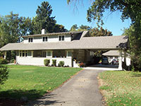
History of 1106 Woodlawn Street, Walla Walla, WA

Property Description:
Commencing at a point which is 175 feet South of the Northeast corner of Block 6 in Spring Creek Addition No. 1 to the City of Walla Walla, according to the official plat thereof of record in the office of the Auditor of said County of Walla Walla, and running thence South 150 feet along the West line of Woodlawn Avenue; thence West 205 feet, parallel to the North line of said Block 6; thence North, 150 feet parallel to the West line of Woodlawn Avenue; thence East 205 feet to the place of beginning.
ALSO, commencing at a point which is 175 feet South of the Northeast corner of Lot 6 (sic.) in Spring Grove Addition No. 1 to the City of Walla Walla, according to the official plat thereof of record in the office of the Auditor of said County of Walla Walla, and running thence North to the West line of Woodlawn Avenue 20 feet; thence West parallel to the North line of said Block 6, 265 feet; thence South parallel to the West line of Woodlawn Avenue 170 feet; thence East parallel to the North line of Block 6, 60 feet, more or less, to the Southwest corner of the lands last above described; thence North parallel to the West line of Woodlawn Avenue and along the West line of said lands last above described, 150 feet to the Northwest corner of said lands; thence East 205 feet along the North line of the said lands last above described, to the point of beginning.
ALSO, beginning at the southwest corner of Block 6 of Spring Grove Addition No. 1 to the City of Walla Walla, according to the official plat thereof of record in the office of the Auditor of said County of Walla Walla, and running thence North 89º 57’ East, along the South line said Block 6, a distance of 395 feet; thence North 00º04’ East 267.0 feet to a point which is the TRU POINT OF BEGINNING of the tract to be described. From the true point of beginning so ascertained run North 00º04’ East 8.0 feet to a point in the South line of the tract in Spring Grove Addition No. 1 first above described; thence South 89º57’ West 60.0 feet to the Southwest corner of said tract first above described; thence South 00º04’ West 36.2 feet to the center of Stone Creek; thence North 68º55’ East 36.0 feet; thence North 59º27’ East 30.5 feet to the point of beginning.
ALSO, beginning at the Northeast corner of Block 6 of Spring Grove Addition No. 1 to the City of Walla Walla, according to the official plat thereof of record in the office of the Auditor of said County of Walla Walla, and running thence South along the East line of said Block, a distance of 155.0 feet; thence West and parallel to the North line of said Block 6, a distance of 265.0 feet to a point in the North line of said Block; thence East on said North line 265.0 feet to the point of beginning.
Together with all ground an surface water rights appurtenant thereto.
Title History:
Washington Territory was created in 1853. In 1884 the new legislature created Walla Walla County which stretched from the crest of the Cascade Mountains to the crest of the Rocky Mountains in the present states of Washington, Idaho and Montana. In 1855 Isaac Stevens held a council on the banks of Mill Creek at the present site of Walla Walla with representatives of regional Indian tribes to purchase land from them. The Yakimas, Cayuses and Walla Wallas were dissatisfied with the treaties and war followed. Missionaries, former French-Canadian employees of the Hudson Bay Company trading post at Wallula, and soldiers at the military Fort Walla Walla were the primary European occupants of the area prior to 1859 when it was opened for settlement. All of the land in the Walla Walla area was acquired from the Cayuse and Walla Walla Indian tribes by the U.S. Government in a treaty signed on June 9, 1855 in Walla Walla, and ratified on March 8, 1859 by President James Buchanan.
Walla Walla was originally laid out by County Surveyor H.H. Case in 1859, even before its formal incorporation as a city in 1862, as a one-quarter mile square with its eastern side centered on the point where Main Street crossed Mill Creek (at roughly the point where it does now). The City of Walla Walla received a Trustee Townsite from the U. S. government which consisted of 80 acres issued on July 20, 1869 by the Vancouver, W.T. District Land Office.
The first patent holders of this southwest quarter of the northwest quarter of Section 28, Township 7N, Range 36E were Thomas Cantrill who purchased 40 acres for cash, with a patent issued by the Vancouver Land Office on April 1, 1865. The first Walla Walla Land Office entry in the legal title to this property was when Joshua Isaacs platted it as Spring Grove Addition No. 1 (recorded on June 14, 1890). His father, Henry P. Isaacs, was instrumental in developing the city water system, growing wheat in this area and establishing flour mills throughout the Northwest and Asian countries. On March 30, 1889 J. C. Isaacs, Bessie J. Isaacs, Grace Isaacs and Charlotte Isaacs, children of H.P. Isaacs, signed a Warranty Deed to Mrs. Sarah Goodman and A. McDonald for Blocks 5 and 6 of Spring Grove Addition plus “a small portion” ( .25 acre) to Walla Walla County for a bridge to be built across Garrison Creek. This deed excluded a water right which had been leased by the Isaacs’s Walla Walla Water Company from John Bryant. On December 1, 1899 the Walla Walla Water Company was sold to the City of Walla Walla for $60,000. On April 16, 1904 Thomas R. Eastman, administrator for the estate of Alexander McDonald conveyed an undivided half interest in Blocks 5 and 6 to Sarah Goodman, who now solely owned this property. Mrs. Goodman lived in San Francisco when her agent, J. P. Kent, signed an agreement to sell the “Goodman and McDonald Tract” (around 20 acres) to M. C. Moore and Sons for $10,000. E. L. and M. S. Goodman signed a Quit Claim Deed on December 30, 1905. On this date Sarah Goodman, widow, signed a Warranty Deed for Blocks 5 and 6 to M. C. Moore and Sons.
In 1863, as an 18 year old, Miles Conway Moore came west from Wisconsin over the newly constructed Mullan Road, from Fort Benton (on the Missouri River in Montana) to Fort Walla Walla, the first wagon road to cross the Rocky Mountains to the inland Northwest. He married Mary Baker, daughter of Dorsey Syng Baker, in 1873 and joined his father-in-law in the wheat, shipping, trading and banking businesses. He built a large home at the south end of Division on Bryant Avenue in 1884. In 1897 President Benjamin appointed M. C. Moore the governor of Washington Territory. He served for 9 months until Washington became a state. He became president of Baker Boyer Bank in 1897 and died on December 18, 1919.
On January 8, 1924 Frank A. Moore, President of M. C. Moore and Sons, declared his father’s corporation dissolved. At that time the owners of the corporation were to receive the assets (including this property) in kind, without liquidation. On October 11, 1924 the will of Frank A. Moore’s brother, Walter Baker Moore, was admitted to probate in Multnomah County, Oregon. He was one of multiple owners of this property. Frank A. Moore died on January 6, 1936. On April 15, 1940 Robert L. and Elsie P. Moore, brother and trustees for Frank A. Moore, signed a Warranty Deed on Block 6 conveying the title to this property to Arthur C. Thompson, whose wife was Lelah Thompson. Mr. Thompson had been a stenographer at Whitehouse Crawford Company and the manager of Samuel Loney lumber yard before he started his own business as the A. C. Thompson Fuel at 804 East Sumach. He sold “Rock Springs and Utah coal, wood, oil and posts.” On July 31, 1947 Lelah M. Thompson received a Certificate of Ground Water Rights from the State Supervisor of Hydraulics of Washington (Certificate #1, Page 372-D, Declaration of Claim #437).
On August 10, 1978 Baker Boyer Bank, as trustees for Lelah Thompson, signed a deed to this property to George and Bernadine Converse. George was a retired Lt. Col. with the Walla Walla Corps of Engineers. They had lived at 350 South First starting in 1969 and subsequently at The Maples at 364 Catherine Street until they moved to 1106 Woodlawn in 1979. On October 12, 1989, Bernadine Converse, as Personal Representative for the Estate of George Converse, conveyed full title to this property to herself. On November 27, 2001, Mrs. Converse transferred title to this property to her Revocable Living Trust. Following her death, this property was transferred to the Washington State University Foundation on May 9, 2008. On October 20, 2008 WSU signed a deed to this property for Erik and Nicole Gryler.
Occupant History:
The construction and residents of this property are obscured by the ownership by M. C. Moore and Sons from 1905 to 1940. There may have been an unrecorded contract on this property much earlier because the Walla Walla City Directories list A. C. and Lelah M. Thompson as living on Woodlawn Avenue starting in 1909-1910. From 1948 to 1953 Lelah was listed at this location as a widow. In 1956 David and Helen Taylor lived here. Helen Taylor and Lelah Thompson (nee Offner) were sisters. Elsie Moore (widow of Robert L. Moore) was a good friend, benefactor, neighbor at 1111 Woodlawn and possible relative. David Taylor was a brick mason and owner of Taylor Brothers masonry/construction business located at 841 6th Avenue North. He relocated the front door of this house, from the south to the north side. David Taylor died in 1963 but his widow continued to live here until 1978. They were apparently never legal owners of the property. Lt. Col. (ret.) and Mrs. Converse lived in this house from 1979 until his death in 1989. Mrs. Converse lived here until her death in 2008. She often spoke of the beautiful gardens on this property during the Thompson-Taylor years. Dr. and Mrs. Gryler undertook an extensive remodel of this grand old home, moving into it in 2010.
Construction of the Home:
The Walla Walla County Assessor’s Office lists a construction date of 1909. This is confirmed by the city directory listing A. C. and Lehla Thompson living on Woodlawn (there were no house numbers at that time) in 1909-1910. No building permit or fire map was found, given this property’s rural location.
References:
Andres, Penny, Walla Walla Her Historic Homes, Vol. I, 1991
Andres, Penny, Walla Walla Her Historic Homes, Vol. II, 1993
Archive, Whitman College Penrose Library
Bennett, Robert A., Walla Walla Portrait of a Western Town 1804-1899, Pioneer Press, Walla Walla, 1980.
BLM Land Patent Records
Building Permits: Whitman College Penrose Library Archives.
Gilbert, Frank T.; Historic Sketches of Walla Walla, Whitman and Garfield Counties, Washington Territory, and Umatilla County, Oregon, 1882
Lyman, Professor W.I., An Illustrated History of Walla Walla County 1901.
Mountain View Cemetery records
Taylor, Doug, personal communication.
U.S. Census records
Walla Walla City Directories: 1880-present (various publishers–not all years).
Mary E. Meeker ; Walla Walla 2020 Research Service December, 2010


