History of 1104 East Alder Street, Walla Walla, WA
Legal Description
The west sixty-two and one-half (62.5) feet of Lot Nine (9) and Ten (10) in Block Five (5) of Watertown Addition to the City of Walla Walla, according to the Official Plat recorded May 14, 1906 in Volume C at Page 56, Records of Walla Walla County, Washington
Title and Occupant History
Washington Territory was created in 1853. In 1854, the new territorial legislature created Walla Walla County, which stretched from the crest of the Cascade Mountains to the crest of the Rocky Mountains in the present states of Washington, Idaho and Montana. In 1855, Isaac Stevens, governor of Washington Territory, held a council on the banks of Mill Creek at the present site of Walla Walla with representatives of regional Indian tribes to purchase land from them. The Yakamas, Cayuses and Walla Wallas were dissatisfied with the treaties and the intrusion by whites into their lands before the treaties’ ratification, and war followed. Missionaries, former French-Canadian employees of the Hudson Bay Company trading post at Wallula, and soldiers at the military Fort Walla Walla were the primary European occupants of the area prior to 1859, when the treaties were finally ratified and the land was opened for settlement. The transfer of ownership occurred by virtue of a treaty signed on June 9, 1855 in Walla Walla and ratified on March 8, 1859 by President James Buchanan, in which all of the land in the Walla Walla area was acquired from the Cayuse and Walla Walla Indian tribes.
The town of Walla Walla was originally laid out by County Surveyor H. H. Case in 1859, prior to its formal incorporation as a city in 1862, as a one-quarter mile square with its eastern side centered on the point where Main Street crossed Mill Creek (at roughly the point where it does now). Case’s plan was filed and recorded July 5, 1867 in Book A of Plats, Page 1. The City of Walla Walla received a Trustee Town site from the U. S. Government that consisted of 80 acres, issued on July 20, 1869 by the Vancouver, W. T. District Land Office.
The first patent holder of the southwest quarter of the southeast quarter of Section 21, Township 7N, Range 36E, in what is now the city of Walla Walla, was Samuel Phinney. He purchased 160 acres from the United States Government in April 1, 1865. It was registered in the Vancouver, W. T. Land Office.
1/9/1878, Warranty Deed for 12 acres of the above property including the land where this home is now located, C. S. and Nancy Bush, grantors; Thomas Collins, grantee, $8,000 in gold coin. Thomas Collins was proprietor of The Walla Walla Driving Park that appears to have been located on the site that became Walla Walla’s early fairgrounds.
1/1/1882, Lease, Thomas and Laura Collins, obligors; James A. Messenger, obligee; 12 acres @ $80/month in gold coin beginning 1/1/1882, filed 4/27/1883. Messenger was a constable.
5/11/1883, Assignment of Lease, James A. Messenger, obligor; Charles Russell, obligee, $975 to transfer and assign forever Messenger’s rights in the above property. Russell, a farmer, lived “3 mi. se” of the city.
6/5/1883, Warranty Deed Against Grantors (a form of mortgage) for the above property, Thomas and Laura Collins, grantors; Charles Russell, grantee, $13,200 to be paid to Charles Russell and his heirs.
3/12/1886, Warranty Deed, Charles and Annie Russell, grantors; Walla Walla Driving Park and Agricultural Association, a corporation, grantee, $8,000 for “12 acres more or less.” This appears to have been to release the above mortgage and leasehold on the above property.
9/2/1886, Warranty Deed for the above property, Walla Walla Driving Park and Agricultural Association, a corporation, grantor; Walla Walla Consolidated Agricultural Association, a corporation, grantee, $10,000.
6/23/1897, Sheriff’s Deed, William Ellingsworth, Sheriff to W. P. Reser, Trustee for various creditors of Walla Walla Valley Consolidated Agricultural Society, including W. P. Reser, Alex Cameron, Chris Ennis, Harvey Shaw, Milton Aldrich, Mike Toner, F. M. Lowden, Phillip Yenney, Hiram Nelson, W. O’Donnell, James McInroe, Thomas Quinn, John Dooly, John Alheit, B. Ferrel and John G. Paine, to confirm the Sheriff’s Sale of said property on 5/29/1895 for $20,795.85 in gold coin, “the highest and best bid,” in an action against the Agricultural Society in Walla Walla County Superior Court.
Following multiple additional lawsuits, various parties represented by W. P. Reser quit claimed a total of 58 acres, including this property, to The Garden City Land Company, a corporation.
4/25/1903, Sheriff’s Deed, Charles S. Painter, Sheriff to W. P. Reser, Trustee, 3 parcels, including this property, containing “44 acres more or less,” 12 acres and 2 acres, $20,795.85.
11/3/1903, Warranty Deed, The Garden City Land Company, a corporation, grantor; Joseph McCabe, grantee, the three parcels in the Sheriff’s Deed of 4/25/1903, $17,500. Joseph McCabe was Vice President and General Manager of the Washington and Columbia River Railway with offices and depot on the northwest corner of East Main and South Palouse Streets. McCabe platted the town of Watertown in 1903.
On 5/11/1904, 14 of the owners of the three parcels listed in the Certificate of Purchase on 5/29/1895 quit claimed the three parcels of “44 acres more or less,” 12 and two acres.
10/2/1905, Quit Claim Deed, Joseph and Ella L. McCabe, grantors; Thomas Mosgrove, grantee, Lots 9 and 10, Block 5 (plus 94 other lots) in the Watertown Addition, $1. Thomas Mosgrove, a realtor, was President of The Watertown Company with residence at 104 Park Street.
6/7/1906, Deed, Thomas Mosgrove, grantor; Kittie Mosgrove, his wife, grantee; the 96 lots listed in the Quit Claim Deed of 10/2/1905.
6/9/1906, Warranty Deed, Kittie Mosgrove, grantor; The Watertown Company, a corporation, grantee, $1.
2/6/1911, Indenture, The Watertown Company, a corporation, grantor; James Hanley, grantee, Lots 9 and 10, Block 5, $1 in gold coin. This is the first transaction involving the two lots that currently define 1104 East Alder Street. James Hanley was a clerk at W. P. McKean, men’s furnishings, 127 West Main. (While city directories indicate the Hanleys resided at 1104 East Alder until selling the property in 1920, city directories also indicate three other married couples residing at the address in 1915, 1916 and 1920 respectively for whom no deeds of ownership exist. It would appear that perhaps the Hanleys rented out a portion of their home.)
1/7/1920, Statutory Warranty Deed, James and Lizzie Hanley, grantors; Henry and Mary Jane Gantenbein, grantees, $10 and other valuable considerations. No occupation was listed in the city directory for Gantenbein, but it does state he paid $1,350 for the house, not a subject normally found in directories.
3/27/1922, Statutory Warranty Deed, Henry and Mary Jane Gantenbein, grantors; Daisy B. Hall, grantee, $4,000.
1/27/1927, Quit Claim Deed, James H. Hall, grantor; Daisy B. Hall, wife of the said party of the first part, grantee, $1. James Hall was listed as a brakeman. Following his death, she married George Montgomery and continued to reside at 1104 East Alder. The Walla Walla Union-Bulletin on August 22, 1946 reported the death of Mr. Montgomery, noting that he had retired as superintendent of Pioneer Park, directly across McKinley Street from 1104 East Alder, on April 24th due to ill health.
3/25/1947, Warranty Deed, Daisy B. Montgomery, formerly Daisy B. Hall, dealing with her own separate property, grantor; Daniel P. and Ava A. Henderson, grantees, $10. Mr. Henderson was a laborer with the State Department of Highways.
1/17/1973, Statutory Warranty Deed, Daniel P. Henderson, Jr., as his separate estate, grantor; Walter F. and Minnie M. Bundy, grantees, $10 and other valuable considerations. Mr. Bundy was a custodian with Blue Mountain Action Council.
9/1/1989, Real Estate Contract, Walter F. and Minnie M. Bundy, sellers; Dean M. and Lupe I. Binney, buyers, $19,950.
6/12/1990, Purchaser’s Assignment of Contract and Deed, Dean M. and Lupe I. Binney, grantors; Frederick C. and Marie Collins, grantees. Dean Binney was employed at Family Medical Center.
9/30/1998, Real Estate Contract, Frederick C. and Marie Collins, sellers; Roberto and Patricia Garcia, buyers, $62,000.
6/19/2017, Warranty Deed, Roberto Garcia, grantor; Curtis L. and Lisa D. Esteb, grantees.
Construction of Building
The location for 1104 East Alder Street does not appear on the original 1905 Sanborn Fire Map, as the maps for that issue terminated at Division Street, the east boundary of Walla Walla at the time. However, the footprint of the house may be viewed clearly on the first update to the 1905 map in July 1909.
Building permits at Whitman Archives reveal that on January 8, 1908 Permit #56 was issued to James Hanley for a “one story frame cottage” to be built at “Alder and McKinley” for a projected cost of $1,950. Mr. Hanley paid one dollar for the permit. The contractor was listed as W. Stalker. Walter R. Stalker was listed, both alphabetically and in the business section of the 1908 City Directory, as an architect, with office and residence at 116 North 5th. Thus, it can be concluded that the house dates to 1908, probably designed by and certainly constructed by Mr. Stalker. There is no listing for James or Lizzie Hanley in the 1908 Walla Walla City Directory. The 1909-1910 edition of the directory lists the Hanleys as residing at 1104 East Alder Street.
Walla Walla County Assessor records indicate a build date of 1906. The Title History indicates the property was not transferred to James Hanley until 2/6/1911. Hanley apparently purchased the property by real estate contract in late 1907 prior to issuance of the building permit in early 1908, and the deed was conveyed in 1911 upon satisfaction of the contract.
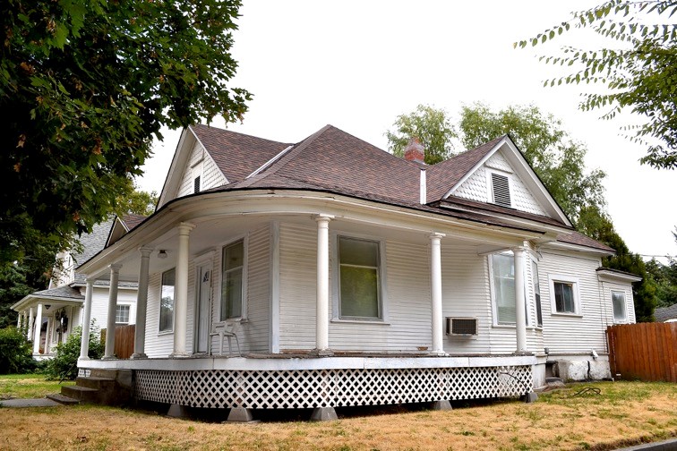
From an architectural perspective, 1104 East Alder Street presents an early 20th-century workingman’s bungalow with limited craftsman embellishments. It is a one-story house with an unfinished attic. Its hipped roof is punctuated by three dormers, one on the front and one on each side; an additional small dormer or faux pediment projects from the porch roof at the front entrance. These are clad in fishscale shingles; the balance of the siding is clapboard. A generous wraparound porch extends across the front of the house, curving around the west side where it terminates at a projecting bay window. The porch is supported by seven round columns, lacking capitols and resting on simple square plinths; this type of column is prevalent on Walla Walla houses of this type and period, and were likely manufactured locally. What was originally a back porch has been enclosed.
References
- Whitman Archives
- Walla Walla City Directories
- Sanborn Fire Maps
- Lyman, W. D., Lyman’s History of Old Walla Walla County, Vol. II, Chicago, 1918
- Susan Monahan, Walla Walla Historian, Vice President Kirkman House Museum


